Bank Wood

Wood, Forest in Radnorshire

Wales

Bank Wood

Overtaking lane on the A470 On the hill entering Newbridge-on-Wye from the north
Overtaking lane on the A470 Credit: Eirian Evans

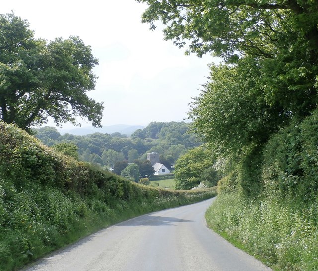
Bank Wood is a picturesque forest located in the county of Radnorshire, Wales. Covering an area of approximately 50 acres, it is a popular destination for nature enthusiasts and visitors seeking tranquility amidst the stunning natural surroundings.

The woodland is characterized by a diverse range of tree species, including oak, beech, birch, and ash. This rich variety of trees creates a vibrant and ever-changing landscape throughout the seasons. The forest floor is covered in a thick carpet of moss, ferns, and wildflowers, further enhancing the beauty of the woodland.

Bank Wood boasts a network of well-marked trails, allowing visitors to explore the forest at their own pace. These paths wind through the forest, leading to hidden glades, babbling brooks, and enchanting clearings. The peaceful ambiance of the woodland provides an ideal setting for hiking, birdwatching, and photography.

The forest is also home to a diverse array of wildlife. Bird species such as woodpeckers, jays, and thrushes can be spotted among the treetops, while smaller creatures like squirrels and rabbits scurry through the undergrowth. In the spring and summer months, the air is filled with the gentle hum of bees and butterflies fluttering from flower to flower.

Bank Wood is a true haven for nature lovers, offering a serene escape from the hustle and bustle of everyday life. Its idyllic setting, diverse flora and fauna, and well-maintained trails make it a must-visit destination for anyone seeking a peaceful and immersive woodland experience in Radnorshire.

If you have any feedback on the listing, please let us know in the comments section below.

Bank Wood Images

Images are sourced within 2km of 52.213601/-3.4151027 or Grid Reference SO0358. Thanks to Geograph Open Source API. All images are credited.

Overtaking lane on the A470 On the hill entering Newbridge-on-Wye from the north
Overtaking lane on the A470
On the hill entering Newbridge-on-Wye from the north
Cutting for A470 near Brookfield
The church in Wyvern, Newbridge-on-Wye
Old Milestone by the A470, Newbridge on Wye, Llanyre Parish By the A470, in parish of Llanyre (Powys District), Newbridge-on-Wye, 30m North of New Inn on verge, East side of road.

Inscription reads:- 
TO / RHAYADER / 8 MILES / BUILTH / 5 

Milestone Society National ID: RAD_RYBU08.
Old Milestone by the A470, Newbridge on Wye, Llanyre Parish
By the A470, in parish of Llanyre (Powys District), Newbridge-on-Wye, 30m North of New Inn on verge, East side of road. Inscription reads:- TO / RHAYADER / 8 MILES / BUILTH / 5 Milestone Society National ID: RAD_RYBU08.
The Golden Lion, Newbridge-on-Wye
Ordnance Survey Cut Mark This OS cut mark can be found on the east face of the Old Lion Cottage. It marks a point 165.517m above mean sea level.
Ordnance Survey Cut Mark
This OS cut mark can be found on the east face of the Old Lion Cottage. It marks a point 165.517m above mean sea level.
Ordnance Survey Cut Mark This OS cut mark can be found on the west face of Ridgemount House. It marks a point 174.473m above mean sea level.
Ordnance Survey Cut Mark
This OS cut mark can be found on the west face of Ridgemount House. It marks a point 174.473m above mean sea level.
View of the Church at Disserth
Lane at Newcastle
Lane at Newcastle
Quackers Play Barn
Quackers Play Barn
All Saints Church - Newbridge on Wye
Newbridge-on-Wye, The New Inn Hotel The New Inn is one of the oldest buildings in Newbridge. Dating from the sixteenth century, it was originally a row of stone cottages, which have since been considerably extended.
Newbridge-on-Wye, The New Inn Hotel
The New Inn is one of the oldest buildings in Newbridge. Dating from the sixteenth century, it was originally a row of stone cottages, which have since been considerably extended.
All Saints Church Builth Wells
Wellington Road (A483) The A483 is a major north-south trunk road in Wales, running for 149 miles between Chester and Junction 42 of the M4 motorway just east of Swansea.
<span class="nowrap"><a title="http://www.sabre-roads.org.uk/wiki/index.php?title=A483" rel="nofollow ugc noopener" href="http://www.sabre-roads.org.uk/wiki/index.php?title=A483">Link</a><img style="margin-left:2px;" alt="External link" title="External link - shift click to open in new window" src="https://s1.geograph.org.uk/img/external.png" width="10" height="10"/></span>  SABRE
<span class="nowrap"><a title="https://en.wikipedia.org/wiki/A483_road" rel="nofollow ugc noopener" href="https://en.wikipedia.org/wiki/A483_road">Link</a><img style="margin-left:2px;" alt="External link" title="External link - shift click to open in new window" src="https://s1.geograph.org.uk/img/external.png" width="10" height="10"/></span>  Wikipedia
Wellington Road (A483)
The A483 is a major north-south trunk road in Wales, running for 149 miles between Chester and Junction 42 of the M4 motorway just east of Swansea. LinkExternal link SABRE LinkExternal link Wikipedia
A483 near to Howey The A483 is a major north-south trunk road in Wales, running for 149 miles between Chester and Junction 42 of the M4 motorway just east of Swansea.
<span class="nowrap"><a title="http://www.sabre-roads.org.uk/wiki/index.php?title=A483" rel="nofollow ugc noopener" href="http://www.sabre-roads.org.uk/wiki/index.php?title=A483">Link</a><img style="margin-left:2px;" alt="External link" title="External link - shift click to open in new window" src="https://s1.geograph.org.uk/img/external.png" width="10" height="10"/></span>  SABRE
<span class="nowrap"><a title="https://en.wikipedia.org/wiki/A483_road" rel="nofollow ugc noopener" href="https://en.wikipedia.org/wiki/A483_road">Link</a><img style="margin-left:2px;" alt="External link" title="External link - shift click to open in new window" src="https://s1.geograph.org.uk/img/external.png" width="10" height="10"/></span>  Wikipedia
A483 near to Howey
The A483 is a major north-south trunk road in Wales, running for 149 miles between Chester and Junction 42 of the M4 motorway just east of Swansea. LinkExternal link SABRE LinkExternal link Wikipedia
Howey, A483 The A483 is a major north-south trunk road in Wales, running for 149 miles between Chester and Junction 42 of the M4 motorway just east of Swansea.
<span class="nowrap"><a title="http://www.sabre-roads.org.uk/wiki/index.php?title=A483" rel="nofollow ugc noopener" href="http://www.sabre-roads.org.uk/wiki/index.php?title=A483">Link</a><img style="margin-left:2px;" alt="External link" title="External link - shift click to open in new window" src="https://s1.geograph.org.uk/img/external.png" width="10" height="10"/></span>  SABRE
<span class="nowrap"><a title="https://en.wikipedia.org/wiki/A483_road" rel="nofollow ugc noopener" href="https://en.wikipedia.org/wiki/A483_road">Link</a><img style="margin-left:2px;" alt="External link" title="External link - shift click to open in new window" src="https://s1.geograph.org.uk/img/external.png" width="10" height="10"/></span>  Wikipedia
Howey, A483
The A483 is a major north-south trunk road in Wales, running for 149 miles between Chester and Junction 42 of the M4 motorway just east of Swansea. LinkExternal link SABRE LinkExternal link Wikipedia
A483, Howey The A483 is a major north-south trunk road in Wales, running for 149 miles between Chester and Junction 42 of the M4 motorway just east of Swansea.
<span class="nowrap"><a title="http://www.sabre-roads.org.uk/wiki/index.php?title=A483" rel="nofollow ugc noopener" href="http://www.sabre-roads.org.uk/wiki/index.php?title=A483">Link</a><img style="margin-left:2px;" alt="External link" title="External link - shift click to open in new window" src="https://s1.geograph.org.uk/img/external.png" width="10" height="10"/></span>  SABRE
<span class="nowrap"><a title="https://en.wikipedia.org/wiki/A483_road" rel="nofollow ugc noopener" href="https://en.wikipedia.org/wiki/A483_road">Link</a><img style="margin-left:2px;" alt="External link" title="External link - shift click to open in new window" src="https://s1.geograph.org.uk/img/external.png" width="10" height="10"/></span>  Wikipedia
A483, Howey
The A483 is a major north-south trunk road in Wales, running for 149 miles between Chester and Junction 42 of the M4 motorway just east of Swansea. LinkExternal link SABRE LinkExternal link Wikipedia
A483, Crossway The A483 is a major north-south trunk road in Wales, running for 149 miles between Chester and Junction 42 of the M4 motorway just east of Swansea.
<span class="nowrap"><a title="http://www.sabre-roads.org.uk/wiki/index.php?title=A483" rel="nofollow ugc noopener" href="http://www.sabre-roads.org.uk/wiki/index.php?title=A483">Link</a><img style="margin-left:2px;" alt="External link" title="External link - shift click to open in new window" src="https://s1.geograph.org.uk/img/external.png" width="10" height="10"/></span>  SABRE
<span class="nowrap"><a title="https://en.wikipedia.org/wiki/A483_road" rel="nofollow ugc noopener" href="https://en.wikipedia.org/wiki/A483_road">Link</a><img style="margin-left:2px;" alt="External link" title="External link - shift click to open in new window" src="https://s1.geograph.org.uk/img/external.png" width="10" height="10"/></span>  Wikipedia
A483, Crossway
The A483 is a major north-south trunk road in Wales, running for 149 miles between Chester and Junction 42 of the M4 motorway just east of Swansea. LinkExternal link SABRE LinkExternal link Wikipedia
Show me another place!

Bank Wood is located at Grid Ref: SO0358 (Lat: 52.213601, Lng: -3.4151027)

Unitary Authority: Powys

Police Authority: Dyfed Powys

What 3 Words

///clouds.shortens.mystified. Near Llandrindod Wells, Powys

Related Wikis

Disserth and Trecoed

Disserth and Trecoed is an electoral ward and community in central Powys, Wales (the historic county of Radnorshire). It has a population of 1,239 according...

Newbridge-on-Wye

Newbridge-on-Wye (Welsh: Y Bontnewydd-ar-Wy) is a small village in Powys, Wales. It lies, as its name suggests, on the River Wye, just downstream from...

Newbridge on Wye railway station

Newbridge on Wye railway station stood on the single-tracked Mid Wales Railway between Builth Wells and Rhayader. It was closed on 31 December 1962 and...

River Ithon

The River Ithon (Welsh: Afon Ieithon) is a major left-bank tributary of the River Wye in Powys, mid Wales. It rises in the broad saddle between the western...

Nearby Amenities

Located within 500m of 52.213601,-3.4151027
Disserth
Is In: Powys,Wales,UK
Name Cy: Diserth
Name En: Disserth
Place: village
Source: npe
Wikidata: Q20590733
Lat/Long: 52.2154337/-3.4134389
The data included in this document is from www.openstreetmap.org. The data is made available under ODbL.

Have you been to Bank Wood?

Leave your review of Bank Wood below (or comments, questions and feedback).