Allt Goch

Wood, Forest in Brecknockshire

Wales

Allt Goch

B4519 heading down the hill The B4519 has a dramatic descent off the Mynydd Epynt into the Irfon valley below. The view is north of west across that valley towards the big hills on the eastern fringe of the Cambrian Mountains. The red flag is flying, so there will be no pedestrian excursions across the military ranges.
B4519 heading down the hill Credit: Gordon Hatton

Allt Goch is a charming woodland nestled in the heart of Brecknockshire, Wales. Located in the Brecon Beacons National Park, this captivating forest covers an area of approximately 500 acres. The name Allt Goch translates to "red hillside," which is derived from the vibrant hues that adorn the landscape during autumn.

The woodland boasts a diverse range of flora and fauna, making it a haven for nature enthusiasts. Towering oak, beech, and ash trees dominate the forest, creating a dense canopy that provides shelter for a host of wildlife. Visitors can expect to encounter various bird species, including woodpeckers, owls, and songbirds. Additionally, red squirrels, foxes, and badgers are often spotted among the undergrowth.

Tranquil streams meander through the forest, adding to the enchanting atmosphere. These waterways are home to a variety of aquatic creatures, such as trout and freshwater crayfish. Explorers can follow the network of walking trails that wind through the woodland, allowing them to appreciate the natural beauty of Allt Goch up close.

The forest is particularly popular during the autumn months when the changing leaves paint the landscape in a stunning array of reds, oranges, and golds. Many visitors flock to Allt Goch to witness this breathtaking display of colors and capture the beauty through photography.

Allt Goch, Brecknockshire, offers a tranquil escape from the bustle of everyday life. Whether you are a nature enthusiast or simply seeking solace in nature, this woodland is a must-visit destination within the Brecon Beacons National Park.

If you have any feedback on the listing, please let us know in the comments section below.

Allt Goch Images

Images are sourced within 2km of 52.118331/-3.5400004 or Grid Reference SN9447. Thanks to Geograph Open Source API. All images are credited.

B4519 heading down the hill The B4519 has a dramatic descent off the Mynydd Epynt into the Irfon valley below. The view is north of west across that valley towards the big hills on the eastern fringe of the Cambrian Mountains. The red flag is flying, so there will be no pedestrian excursions across the military ranges.
B4519 heading down the hill
The B4519 has a dramatic descent off the Mynydd Epynt into the Irfon valley below. The view is north of west across that valley towards the big hills on the eastern fringe of the Cambrian Mountains. The red flag is flying, so there will be no pedestrian excursions across the military ranges.
Cammarch Hotel, Llangammarch
The lake at The Lake Hotel, Llangammarch
Coprinus comatus Shaggy ink cap or lawyer’s wig.

See <span class="nowrap"><a title="https://en.wikipedia.org/wiki/Coprinus_comatus" rel="nofollow ugc noopener" href="https://en.wikipedia.org/wiki/Coprinus_comatus">Link</a><img style="margin-left:2px;" alt="External link" title="External link - shift click to open in new window" src="https://s1.geograph.org.uk/img/external.png" width="10" height="10"/></span>.
Coprinus comatus
Shaggy ink cap or lawyer’s wig. See LinkExternal link.
Shaggy ink cap Coprinus comatus in a later, decaying stage of its life cycle.

See also <a href="https://www.geograph.org.uk/photo/7313928">SN9447 : Coprinus comatus</a>.
Shaggy ink cap
Coprinus comatus in a later, decaying stage of its life cycle. See also SN9447 : Coprinus comatus.
Boletus edulis Commonly known as a ‘penny bun’, I believe.

See <span class="nowrap"><a title="https://en.wikipedia.org/wiki/Boletus_edulis" rel="nofollow ugc noopener" href="https://en.wikipedia.org/wiki/Boletus_edulis">Link</a><img style="margin-left:2px;" alt="External link" title="External link - shift click to open in new window" src="https://s1.geograph.org.uk/img/external.png" width="10" height="10"/></span>
Boletus edulis
Commonly known as a ‘penny bun’, I believe. See LinkExternal link
St Cadmarch’s Church, Llangammarch
Grounds of the Lake Country House Hotel
Part of the River Irfon at Llangammarch Wells The river flows busily around an oval island or eyot in midstream, possibly the result of deposits from the Afon Cammarch which joins the Irfon a short way upstream.
Part of the River Irfon at Llangammarch Wells
The river flows busily around an oval island or eyot in midstream, possibly the result of deposits from the Afon Cammarch which joins the Irfon a short way upstream.
The Cammarch Hotel in Llangammarch Wells Built beside the railway and serving the spa period in the village's history. The Heart of Wales railway line passes immediately to the left and the station is adjacent.
The Cammarch Hotel in Llangammarch Wells
Built beside the railway and serving the spa period in the village's history. The Heart of Wales railway line passes immediately to the left and the station is adjacent.
The Post Office and village store, Llangammarch Wells A hub of the village.
The Post Office and village store, Llangammarch Wells
A hub of the village.
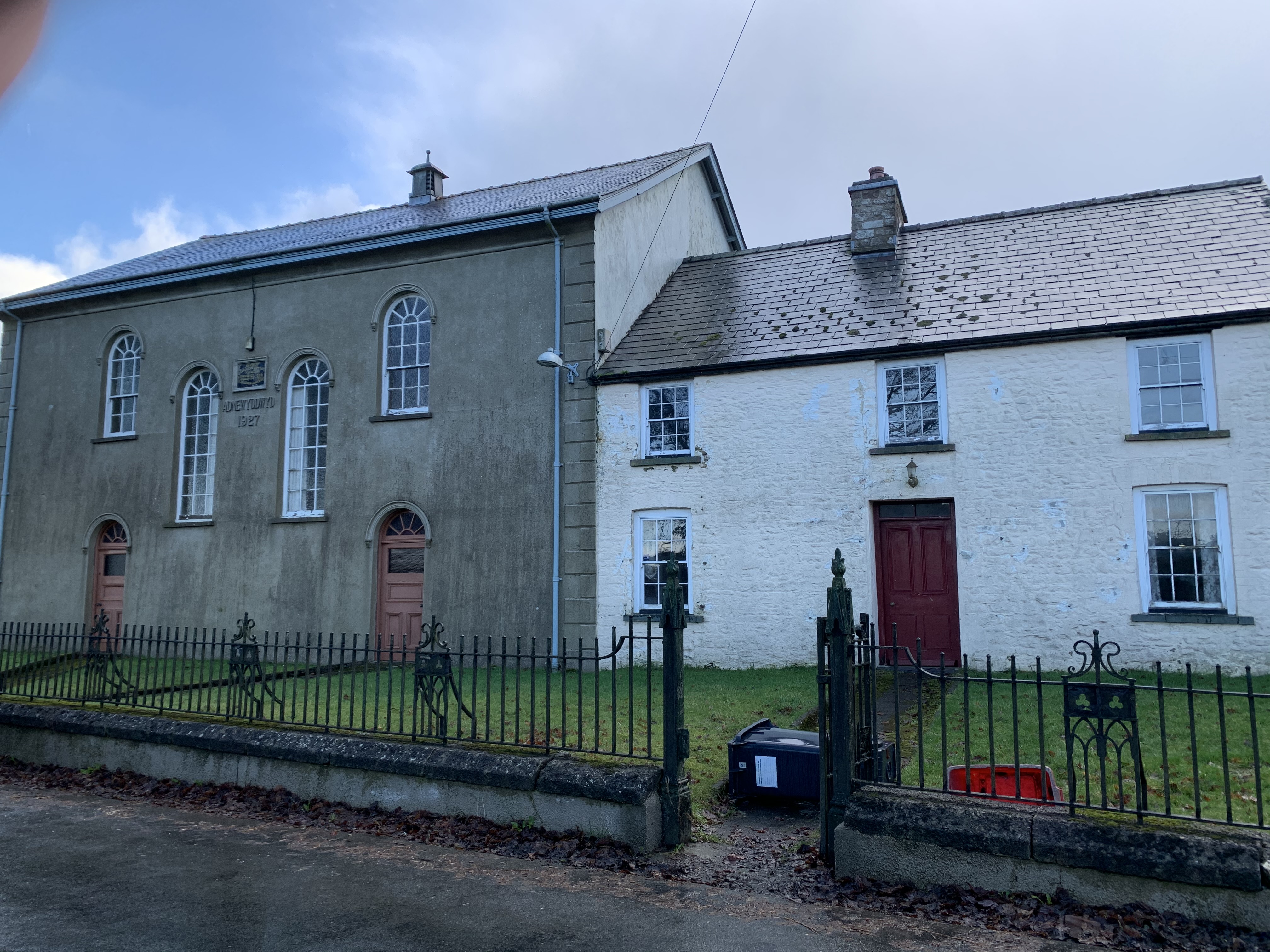
Nazareth chapel in Llangammarch Wells The attached property would have been the original manse I assume. The hall next door was also owned by the chapel and called the Alexandra Hall acting as a community centre, theatre, function room etc etc.

Like most chapels of all denominations (this one is Presbyterian) it looks under used, neglected and unloved as congregations diminish, officials age and attendances drop to zero, along with funds.
Nazareth chapel in Llangammarch Wells
The attached property would have been the original manse I assume. The hall next door was also owned by the chapel and called the Alexandra Hall acting as a community centre, theatre, function room etc etc. Like most chapels of all denominations (this one is Presbyterian) it looks under used, neglected and unloved as congregations diminish, officials age and attendances drop to zero, along with funds.
Presbyterian chapel board, Llangammarch Wells I wonder what the deacons of a century or so ago would say?
Presbyterian chapel board, Llangammarch Wells
I wonder what the deacons of a century or so ago would say?
Part of the B4519 road above Cwm Graig-ddu A steep uphill pull for a cyclist ahead of me. Cars are skylined at the viewpoint far above.
Part of the B4519 road above Cwm Graig-ddu
A steep uphill pull for a cyclist ahead of me. Cars are skylined at the viewpoint far above.
Picnic table at the viewpoint car park above Cwm Graig-ddu I'm no expert but I would have thought that the table should face the view, rather than facing a bank, some boulders and a car park. Why turn your back on a view like this?
Picnic table at the viewpoint car park above Cwm Graig-ddu
I'm no expert but I would have thought that the table should face the view, rather than facing a bank, some boulders and a car park. Why turn your back on a view like this?
View over Cwm Graig-ddu An expansive view over the dramatic cwm and the valley of the River Irfon.
View over Cwm Graig-ddu
An expansive view over the dramatic cwm and the valley of the River Irfon.
Part of the viewpoint car park above Cwm Graig-ddu The distant views take in high ground like Drygarn Fawr, the twin summit cairns can be detected on the skyline.
Part of the viewpoint car park above Cwm Graig-ddu
The distant views take in high ground like Drygarn Fawr, the twin summit cairns can be detected on the skyline.
Drygarn Fawr from the viewpoint above Cwm Graig-ddu on Epynt A good view to the area's higher ground.
Drygarn Fawr from the viewpoint above Cwm Graig-ddu on Epynt
A good view to the area's higher ground.
Show me another place!

Allt Goch is located at Grid Ref: SN9447 (Lat: 52.118331, Lng: -3.5400004)

Unitary Authority: Powys

Police Authority: Dyfed Powys

What 3 Words

///arching.apartment.jeeps. Near Llwyn-Madoc, Powys

Nearby Locations

Allt Goch Coed Pen-lan

Related Wikis

Llangammarch railway station

Llangammarch railway station serves the village of Llangammarch Wells in Powys, Wales. Situated near the centre of the village, the station is on the Heart...

Llangammarch (parish)

Llangammarch was a rural ecclesiastical parish in Powys, mid-Wales, through which flow the rivers Irfon and Cammarch. The main centre of population is...

Llangammarch Wells

Llangammarch Wells or simply Llangammarch (Welsh: Llangamarch) is a village in the community of Llangamarch in Powys, Wales, lying on the Afon Irfon, and...

Dulas, Irfon

Dulas is a left-bank tributary of the Afon Irfon, itself a tributary of the River Wye. It rises on the southeastern slopes of the Elenydd and runs southeast...

Garth railway station (Powys)

Garth railway station (Powys) serves the village of Garth, Powys, Wales. The railway station is located at street level at the end of the Llais yr Afon...

Garth, Powys

Garth is a village in Powys, mid Wales, in the community of Treflys. It lies on the A483 road between Builth Wells and Beulah at the point where the B4519...

Mynydd Epynt

Mynydd Epynt (Welsh: [ˈmənɨð ˈɛpɨnt]) is a former community and upland area in Powys, Wales. The Ministry of Defence controversially evicted the community...

Epynt Way

The Epynt Way is a long-distance path created by the Ministry of Defence in 2004 around the perimeter of its 'Sennybridge Training Area (SENTA)' and artillery...

Nearby Amenities

Located within 500m of 52.118331,-3.5400004
Building: yes
Lat/Long: 52.1186372/-3.5430536
Post Box
Post Box Type: lamp
Ref: LD4 169
Royal Cypher: EIIR
Royal Cypher Wikidata: Q33102113
Lat/Long: 52.1167474/-3.5390114
Power: pole
Lat/Long: 52.1187684/-3.5444239
Power: pole
Lat/Long: 52.1192172/-3.5455155
Power: pole
Lat/Long: 52.1196808/-3.5466072
Power: pole
Lat/Long: 52.117329/-3.5329628
Power: pole
Lat/Long: 52.1170028/-3.5339579
Power: pole
Lat/Long: 52.1166734/-3.5350174
Power: pole
Lat/Long: 52.1163374/-3.5360983
Power: pole
Lat/Long: 52.1159949/-3.5370854
Power: pole
Lat/Long: 52.1157247/-3.5378847
Power: pole
Lat/Long: 52.1150247/-3.5386625
Power: pole
Transformer: distribution
Lat/Long: 52.1148139/-3.5395369
Power: pole
Lat/Long: 52.1145652/-3.5408431
Power: pole
Lat/Long: 52.1143222/-3.5421936
Power: pole
Lat/Long: 52.1150033/-3.5445285
Power: pole
Lat/Long: 52.1155814/-3.5443863
Power: pole
Lat/Long: 52.1158318/-3.5443327
Power: pole
Lat/Long: 52.1165927/-3.5441181
Power: pole
Lat/Long: 52.1174228/-3.5438848
Power: pole
Lat/Long: 52.1184324/-3.5436313
Power: pole
Transformer: distribution
Lat/Long: 52.11416/-3.5389227
The data included in this document is from www.openstreetmap.org. The data is made available under ODbL.

Have you been to Allt Goch?

Leave your review of Allt Goch below (or comments, questions and feedback).