Coed y Foel

Wood, Forest in Radnorshire

Wales

Coed y Foel

Forest path in snow A signed path with small gate links the top edge of the forest with the track above Cwm Coel.  Larch trees bare of needles, snow on the ground, and afternoon light penetrating from the edge of the forest.
Forest path in snow Credit: Andrew Hill

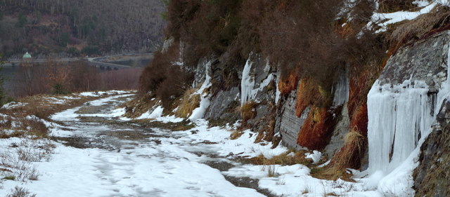
Coed y Foel is a picturesque woodland located in Radnorshire, a historic county in Wales. Spanning an area of approximately 200 acres, the forest is renowned for its natural beauty and rich biodiversity. The name "Coed y Foel" translates to "Wood of the Hill" in English, reflecting its hilly terrain and elevated location.

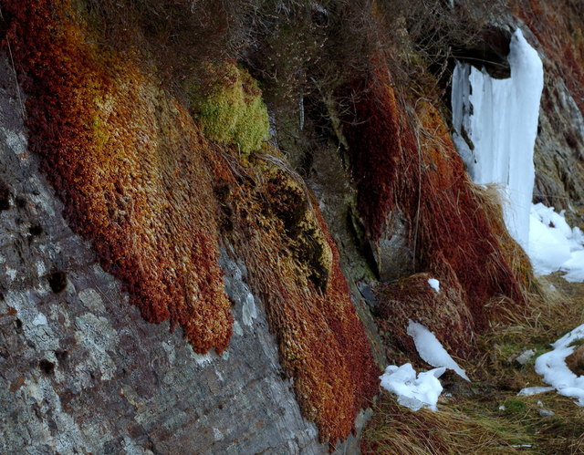
The woodland is predominantly composed of native broadleaf trees, including oak, beech, and birch, which create a dense canopy that filters the sunlight and provides a cool and tranquil atmosphere. The forest floor is adorned with a vibrant carpet of wildflowers, ferns, and mosses, adding to the enchanting ambience of the area.

Coed y Foel is a haven for wildlife, serving as a habitat for numerous species. It is home to a diverse range of birds, including the melodious song thrush, elusive tawny owl, and vibrant woodpeckers. Mammals such as badgers, foxes, and squirrels can also be spotted within the woodland. Additionally, the forest is inhabited by a variety of insect species, contributing to the intricate ecosystem.

The forest offers a network of well-maintained walking trails, allowing visitors to explore its natural wonders. The paths meander through the woodland, offering breathtaking views of the surrounding countryside and glimpses of wildlife. Coed y Foel is a popular destination for nature enthusiasts, hikers, and photographers seeking a peaceful retreat into nature.

In conclusion, Coed y Foel is a captivating woodland in Radnorshire, celebrated for its diverse flora and fauna, scenic beauty, and tranquil atmosphere. It offers a delightful escape from the hustle and bustle of modern life, providing visitors with a chance to reconnect with nature and enjoy the serene surroundings.

If you have any feedback on the listing, please let us know in the comments section below.

Coed y Foel Images

Images are sourced within 2km of 52.265566/-3.5925052 or Grid Reference SN9164. Thanks to Geograph Open Source API. All images are credited.

Forest path in snow A signed path with small gate links the top edge of the forest with the track above Cwm Coel.  Larch trees bare of needles, snow on the ground, and afternoon light penetrating from the edge of the forest.
Forest path in snow
A signed path with small gate links the top edge of the forest with the track above Cwm Coel. Larch trees bare of needles, snow on the ground, and afternoon light penetrating from the edge of the forest.
Cwm Coel forest track Looking down to the reservoirs.  The low rock face to the right was covered with colourful mosses and also icicles as the cold weather was lifting.
Cwm Coel forest track
Looking down to the reservoirs. The low rock face to the right was covered with colourful mosses and also icicles as the cold weather was lifting.
Low rock face with colourful moss and icicles By the Llanerchi Wood forest track to Cwm Coel.  Many overhanging mossy or rocky corners had icicles which were melting in the thaw.
Low rock face with colourful moss and icicles
By the Llanerchi Wood forest track to Cwm Coel. Many overhanging mossy or rocky corners had icicles which were melting in the thaw.
Engine shaft, Cwm Elan Mine This is the partially collapsed main engine shaft at Cwm Elan, used for pumping and winding.  The pump rod remains in the shaft, which was 40 fathoms (240') deep, while an adit level associated with the shaft is visible behind the shaft collar.  The mine operated from the late 18th century to 1877.
Engine shaft, Cwm Elan Mine
This is the partially collapsed main engine shaft at Cwm Elan, used for pumping and winding. The pump rod remains in the shaft, which was 40 fathoms (240') deep, while an adit level associated with the shaft is visible behind the shaft collar. The mine operated from the late 18th century to 1877.
Cwm Elan lead mine This is the masonry waterwheel pit, or wheelcase, for the waterwheel that powered the pumps in the main engine shaft at the Cwm Elan lead mine, which closed in 1877.  The arched opening is the outflow - after turning this wheel, the water was channelled to two further waterwheels lower down the site.
Cwm Elan lead mine
This is the masonry waterwheel pit, or wheelcase, for the waterwheel that powered the pumps in the main engine shaft at the Cwm Elan lead mine, which closed in 1877. The arched opening is the outflow - after turning this wheel, the water was channelled to two further waterwheels lower down the site.
Radio mast at Cefn Llanerchi
Green radio mast with solar panel and wind generator
Masts at Cefn Llanerchi I don't know what these masts do but they are interesting and impressive.
Masts at Cefn Llanerchi
I don't know what these masts do but they are interesting and impressive.
Moorland above Garreg-ddu reservoir
Nantgwyllt Church The Victorian replacement for the Church flooded with the building of the Elan Valley Dams.
Nantgwyllt Church
The Victorian replacement for the Church flooded with the building of the Elan Valley Dams.
Elan River Dam One of the huge dams in the Elan Valley that serves the people of Birmingham with its water supply
Elan River Dam
One of the huge dams in the Elan Valley that serves the people of Birmingham with its water supply
Caban Coch Dam
Caban Coch Dam
Water Treatment Works, Elan
River Elan (Afon Elan) at Elan Valley Visitor Centre Looking upstream from the visitor centre towards the Caban Coch Dam.

The Elan Valley (Welsh: Cwm Elan) is a river valley situated to the west of Rhayader, famous for its picturesque scenery and sometimes known as the "Welsh Lake District". It covers 70 square miles (180 km2) of lake and countryside. Over 80% of the valley is designated as Sites of Special Scientific Interest, and a popular cycle trail, the Elan Valley Trail, makes a loop from Rhayader around the reservoirs. Part of the trail overlaps with a spur of National Cycle Route 81 (Lon Cambria). A visitor centre is located below Caban Coch dam.
River Elan (Afon Elan) at Elan Valley Visitor Centre
Looking upstream from the visitor centre towards the Caban Coch Dam. The Elan Valley (Welsh: Cwm Elan) is a river valley situated to the west of Rhayader, famous for its picturesque scenery and sometimes known as the "Welsh Lake District". It covers 70 square miles (180 km2) of lake and countryside. Over 80% of the valley is designated as Sites of Special Scientific Interest, and a popular cycle trail, the Elan Valley Trail, makes a loop from Rhayader around the reservoirs. Part of the trail overlaps with a spur of National Cycle Route 81 (Lon Cambria). A visitor centre is located below Caban Coch dam.
River Elan (Afon Elan) Bridge and Caban Coch Dam Caban Coch dam is the lowest of a sequence of four the dams in built in the valley of the Elan River built by the Birmingham Corporation Water Department in the late 1890s to provide clean drinking water for the population of Birmingham. It is the simplest and most functional in appearance of all the dams, resembling a natural waterfall when the reservoir is full and the dam is in full spate with water pouring over the dam wall.

The footbridge just below the dam wall connects two identical stone buildings on either side of the river which house electricity generating turbines and valves and sluices to adjust the amount of compensation water released downstream (<span class="nowrap"><a title="http://www.elanvalley.org.uk/discover/reservoirs-dams/6-dams" rel="nofollow ugc noopener" href="http://www.elanvalley.org.uk/discover/reservoirs-dams/6-dams">Link</a><img style="margin-left:2px;" alt="External link" title="External link - shift click to open in new window" src="https://s1.geograph.org.uk/img/external.png" width="10" height="10"/></span>  Visit Elan Valley).
River Elan (Afon Elan) Bridge and Caban Coch Dam
Caban Coch dam is the lowest of a sequence of four the dams in built in the valley of the Elan River built by the Birmingham Corporation Water Department in the late 1890s to provide clean drinking water for the population of Birmingham. It is the simplest and most functional in appearance of all the dams, resembling a natural waterfall when the reservoir is full and the dam is in full spate with water pouring over the dam wall. The footbridge just below the dam wall connects two identical stone buildings on either side of the river which house electricity generating turbines and valves and sluices to adjust the amount of compensation water released downstream (LinkExternal link Visit Elan Valley).
Afon Elan (River Elan) The Afon Elan (River Elan) is a tributary of the River Wye which runs through the wide expanse of upland moors, traditionally known as Elenydd, in central Wales. Its valley is the Elan Valley (<span class="nowrap"><a title="http://www.elanvalley.org.uk/visit" rel="nofollow ugc noopener" href="http://www.elanvalley.org.uk/visit">Link</a><img style="margin-left:2px;" alt="External link" title="External link - shift click to open in new window" src="https://s1.geograph.org.uk/img/external.png" width="10" height="10"/></span>  Visit Elan Valley). It rises  in the wet moorland on the eastern flank of Pen y Deunant and enters the top of the Elan Valley Reservoirs at Craig Goch Reservoir which in turn discharges to Garreg-ddu Reservoir and then Caban-coch Reservoir. It emerges from this chain of reservoirs in a north-easterly direction and passes through Elan Village before turning south-east and making its confluence with the River Wye.
Afon Elan (River Elan)
The Afon Elan (River Elan) is a tributary of the River Wye which runs through the wide expanse of upland moors, traditionally known as Elenydd, in central Wales. Its valley is the Elan Valley (LinkExternal link Visit Elan Valley). It rises in the wet moorland on the eastern flank of Pen y Deunant and enters the top of the Elan Valley Reservoirs at Craig Goch Reservoir which in turn discharges to Garreg-ddu Reservoir and then Caban-coch Reservoir. It emerges from this chain of reservoirs in a north-easterly direction and passes through Elan Village before turning south-east and making its confluence with the River Wye.
River Elan The Afon Elan (River Elan) is a tributary of the River Wye which runs through the wide expanse of upland moors, traditionally known as Elenydd, in central Wales. Its valley is the Elan Valley (<span class="nowrap"><a title="http://www.elanvalley.org.uk/visit" rel="nofollow ugc noopener" href="http://www.elanvalley.org.uk/visit">Link</a><img style="margin-left:2px;" alt="External link" title="External link - shift click to open in new window" src="https://s1.geograph.org.uk/img/external.png" width="10" height="10"/></span>  Visit Elan Valley). It rises  in the wet moorland on the eastern flank of Pen y Deunant and enters the top of the Elan Valley Reservoirs at Craig Goch Reservoir which in turn discharges to Garreg-ddu Reservoir and then Caban-coch Reservoir. It emerges from this chain of reservoirs in a north-easterly direction and passes through Elan Village before turning south-east and making its confluence with the River Wye.
River Elan
The Afon Elan (River Elan) is a tributary of the River Wye which runs through the wide expanse of upland moors, traditionally known as Elenydd, in central Wales. Its valley is the Elan Valley (LinkExternal link Visit Elan Valley). It rises in the wet moorland on the eastern flank of Pen y Deunant and enters the top of the Elan Valley Reservoirs at Craig Goch Reservoir which in turn discharges to Garreg-ddu Reservoir and then Caban-coch Reservoir. It emerges from this chain of reservoirs in a north-easterly direction and passes through Elan Village before turning south-east and making its confluence with the River Wye.
Elan Valley, Caban Coch Dam and Visitor Centre The Elan Valley (Welsh: Cwm Elan) is a river valley situated to the west of Rhayader, famous for its picturesque scenery and sometimes known as the "Welsh Lake District". It covers 70 square miles (180 km2) of lake and countryside. Over 80% of the valley is designated as Sites of Special Scientific Interest, and a popular cycle trail, the Elan Valley Trail, makes a loop from Rhayader around the reservoirs. Part of the trail overlaps with a spur of National Cycle Route 81 (Lon Cambria). The visitor centre is located below Caban Coch dam and can be seen in this photograph.
Elan Valley, Caban Coch Dam and Visitor Centre
The Elan Valley (Welsh: Cwm Elan) is a river valley situated to the west of Rhayader, famous for its picturesque scenery and sometimes known as the "Welsh Lake District". It covers 70 square miles (180 km2) of lake and countryside. Over 80% of the valley is designated as Sites of Special Scientific Interest, and a popular cycle trail, the Elan Valley Trail, makes a loop from Rhayader around the reservoirs. Part of the trail overlaps with a spur of National Cycle Route 81 (Lon Cambria). The visitor centre is located below Caban Coch dam and can be seen in this photograph.
Show me another place!

Coed y Foel is located at Grid Ref: SN9164 (Lat: 52.265566, Lng: -3.5925052)

Unitary Authority: Powys

Police Authority: Dyfed Powys

What 3 Words

///mule.orbited.exact. Near Rhayader, Powys

Nearby Locations

Elan Valley Coed y Foel

Related Wikis

Elan Valley

The Elan Valley (Welsh: Cwm Elan) is a river valley situated to the west of Rhayader, in Powys, Wales, sometimes known as the "Welsh Lake District". It...

Caeau Cnwch a Ty'n-y-graig

Caeau Cnwch a Ty'n-y-graig is a Site of Special Scientific Interest in Brecknock, Powys, Wales. It occupies sloping ground on the south west side of Pen...

Elan Village

Elan Village (Welsh: Pentre Elan) is a small purpose-built community in Powys, Wales. It was designed by architect Herbert Tudor Buckland as part of Birmingham...

Carn Gafallt

Carn Gafallt is a Site of Special Scientific Interest in Breconshire, Powys, Wales, and a hill of 466 metres (1529 feet) which is a Marilyn. == See... ==

Principality of Wales

The Principality of Wales (Welsh: Tywysogaeth Cymru) was originally the territory of the native Welsh princes of the House of Aberffraw from 1216 to 1283...

Claerwen Fault

The Claerwen Fault is a major SW-NE trending fault in central Wales. It was active as a normal fault during deposition of Late Ordovician to mid-Silurian...

Craig Goch Dam

The Craig Goch Dam, often called the Top dam, is a masonry dam in the Elan Valley of Wales and creates the upper-most of the Elan Valley Reservoirs. Construction...

Afon Elan

The Afon Elan (English: River Elan) is a tributary of the River Wye which runs through the wide expanse of upland moors, traditionally known as Elenydd...

Nearby Amenities

Located within 500m of 52.265566,-3.5925052
Source: npe
Lat/Long: 52.269365/-3.5934833
Source: npe
Lat/Long: 52.2670661/-3.5959516
Source: npe
Lat/Long: 52.2657031/-3.5973344
Source: npe
Lat/Long: 52.2635409/-3.5969984
Created By: POI Editor
Source: npe
Lat/Long: 52.2622419/-3.5948848
Source: npe
Lat/Long: 52.2614851/-3.5916348
Created By: POI Editor
Source: npe
Lat/Long: 52.262452/-3.5886079
Bus Stop
Bus: yes
Public Transport: platform
Shelter: no
Source: GPS Survey
Lat/Long: 52.2633723/-3.5961845
Foel Tower
Man Made: tower
Source: survey
Wikidata: Q17742499
Lat/Long: 52.2639992/-3.5976951
WW2 Pillbox
Building: bunker
Bunker Type: pillbox
Military: bunker
Lat/Long: 52.2642976/-3.5969758
WW2 Pill Box
Building: bunker
Bunker Type: pillbox
Military: bunker
Lat/Long: 52.2651896/-3.5968799
WW2 Pill Box
Building: bunker
Bunker Type: pillbox
Military: bunker
Lat/Long: 52.2646497/-3.5970871
Defibrillator
Access: yes
Defibrillator Location: On the dam abutments
Emergency: defibrillator
Indoor: no
Ref GB The Circuit: 453E275F-E65D-43AE-878C-AE1501046DC6
Lat/Long: 52.2635472/-3.5968959
The data included in this document is from www.openstreetmap.org. The data is made available under ODbL.

Have you been to Coed y Foel?

Leave your review of Coed y Foel below (or comments, questions and feedback).