Coed Brwynog

Wood, Forest in Merionethshire

Wales

Coed Brwynog

Maid Marian, Bala Lake Railway Narrow gauge locomotive 'Maid Marian' running onto its train at Llanuwchllyn. Maid Marian was built by Hunslet in 1903 and worked at Dinorwic until 1964. Though narrow gauge, the Bala Lake Railway uses the former trackbed of the Ruabon - Barmouth line between Llanuwchllyn and Bala.
Maid Marian, Bala Lake Railway Credit: David Robinson

The requested URL returned error: 429 Too Many Requests

If you have any feedback on the listing, please let us know in the comments section below.

Coed Brwynog Images

Images are sourced within 2km of 52.870491/-3.6715122 or Grid Reference SH8731. Thanks to Geograph Open Source API. All images are credited.

Maid Marian, Bala Lake Railway Narrow gauge locomotive 'Maid Marian' running onto its train at Llanuwchllyn. Maid Marian was built by Hunslet in 1903 and worked at Dinorwic until 1964. Though narrow gauge, the Bala Lake Railway uses the former trackbed of the Ruabon - Barmouth line between Llanuwchllyn and Bala.
Maid Marian, Bala Lake Railway
Narrow gauge locomotive 'Maid Marian' running onto its train at Llanuwchllyn. Maid Marian was built by Hunslet in 1903 and worked at Dinorwic until 1964. Though narrow gauge, the Bala Lake Railway uses the former trackbed of the Ruabon - Barmouth line between Llanuwchllyn and Bala.
Bala Lake Near Glanllyn Flag Halt The lake viewed from the Bala Lake railway.
Bala Lake Near Glanllyn Flag Halt
The lake viewed from the Bala Lake railway.
Llanuwchllyn village pump Llanuwchllyn village pump sits just off Church Street.
Llanuwchllyn village pump
Llanuwchllyn village pump sits just off Church Street.
The A494 north at Llanuwchllyn village sign
The A494 north at turning for campsite
New use for a Telephone Box The old Telephone Box on Llanuwchylln Station platform has been transformed into a small greenhouse for hanging baskets.
New use for a Telephone Box
The old Telephone Box on Llanuwchylln Station platform has been transformed into a small greenhouse for hanging baskets.
Study of a Gasoline Station Essay, Llanuwchllyn.

 This photograph is part of a series taken in homage to the American artist Ed Ruscha's 1963 publication of 'Twentysix Gasoline Stations'.
 More properly known as filling stations in the UK, I am attempting to photograph as many as possible to mark the sixty year anniversary.
Study of a Gasoline Station
Essay, Llanuwchllyn. This photograph is part of a series taken in homage to the American artist Ed Ruscha's 1963 publication of 'Twentysix Gasoline Stations'. More properly known as filling stations in the UK, I am attempting to photograph as many as possible to mark the sixty year anniversary.
Afon Twrch in high summer Viewed from Pont y Pandy.
Afon Twrch in high summer
Viewed from Pont y Pandy.
Approaching junction with B4403
The B4403 road through Llanuwchllyn The road runs along the south-east side of Bala Lake towards Bala.
The B4403 road through Llanuwchllyn
The road runs along the south-east side of Bala Lake towards Bala.
In Llanuwchllyn With the Bala Lake Railway signposted to the right.
In Llanuwchllyn
With the Bala Lake Railway signposted to the right.
Afon Twrch at Llanuwchllyn One of the main feeders of Llyn Tegid, but before it reaches the lake it has a confluence with Afon Dyfrdwy.
Afon Twrch at Llanuwchllyn
One of the main feeders of Llyn Tegid, but before it reaches the lake it has a confluence with Afon Dyfrdwy.
Afon Twrch at Llanuwchllyn Looking upstream. The bridge carrying the B4403 road is in view.
Afon Twrch at Llanuwchllyn
Looking upstream. The bridge carrying the B4403 road is in view.
The start of the Yr Aran ridge path It ain't so benign further on!
The start of the Yr Aran ridge path
It ain't so benign further on!
The road through Llanuwchllyn With the snow covered Arenigs beyond.
The road through Llanuwchllyn
With the snow covered Arenigs beyond.
Afon Twrch flows down to Llanuwchllyn Viewed from the B4403 bridge.
Afon Twrch flows down to Llanuwchllyn
Viewed from the B4403 bridge.
Afon Twrch looking downstream
Leaving Llanuwchllyn On the B4403 the 'back road' to Bala.
Leaving Llanuwchllyn
On the B4403 the 'back road' to Bala.
Show me another place!

Coed Brwynog is located at Grid Ref: SH8731 (Lat: 52.870491, Lng: -3.6715122)

Unitary Authority: Gwynedd

Police Authority: North Wales

What 3 Words

///monks.concluded.asterisk. Near Llanuwchllyn, Gwynedd

Nearby Locations

Coed Brwynog

Related Wikis

Caer Gai

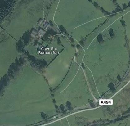
Caer Gai (also Caer-gai) is a Grade II listed Roman fort in the district of Penllyn, Gwynedd, Wales, UK. It is located about 1 mile or 1.6 km north of...

Afon Llafar (Dee)

For the river which flows into the River Ogwen see Afon Llafar.The Afon Llafar is a small river in North Wales which, rising on the eastern slopes of Arenig...

Llanuwchllyn railway station

Llanuwchllyn railway station (Welsh: [ɬaˈnɨuχɬɨn] (listen)) in the village of Llanuwchllyn, Gwynedd, Wales, was formerly a station on the Ruabon to Barmouth...

Llanuwchllyn

Llanuwchllyn (Welsh: [ɬaˈnɨ̞u̯χɬɨn] ) is a village and community in Gwynedd, Wales, near the southern end of Bala Lake (Llyn Tegid). It is one of the most...

Nearby Amenities

Located within 500m of 52.870491,-3.6715122
ROMAN FORT CAER GAI
Place: locality
Lat/Long: 52.8685768/-3.6681511
Power: pole
Lat/Long: 52.8674304/-3.6765318
Power: pole
Lat/Long: 52.8675098/-3.6749434
Power: pole
Lat/Long: 52.8675265/-3.675829
Power: pole
Lat/Long: 52.8677462/-3.6752542
Power: pole
Lat/Long: 52.8678927/-3.6741216
Power: pole
Lat/Long: 52.8722069/-3.676181
Power: pole
Lat/Long: 52.8719113/-3.6766791
Power: pole
Lat/Long: 52.8714847/-3.6770623
Power: pole
Lat/Long: 52.8709835/-3.6769303
Power: pole
Lat/Long: 52.8700815/-3.6768239
Power: pole
Lat/Long: 52.8693181/-3.6759809
Power: pole
Lat/Long: 52.8688812/-3.6758957
Power: pole
Lat/Long: 52.8685754/-3.6753592
Power: pole
Lat/Long: 52.8695205/-3.678249
Power: pole
Lat/Long: 52.868834/-3.6771198
Power: pole
Lat/Long: 52.867895/-3.6752247
Power: pole
Lat/Long: 52.8683548/-3.6761621
The data included in this document is from www.openstreetmap.org. The data is made available under ODbL.

Have you been to Coed Brwynog?

Leave your review of Coed Brwynog below (or comments, questions and feedback).