Allt Gell-fain

Wood, Forest in Brecknockshire

Wales

Allt Gell-fain

Capel Horeb Chapel, Cwmdwr Adfeilion trist Capel Hermon, addoldy'r Bedyddwyr, Cwmdwr ger Llywel. Adeiladwyd y ty cwrdd cyntaf yn 1820 ac fe'i hailgodwyd bron yn gyfan gwbl yn 1905. Daeth yr achos i ben yn Horeb yng nghanol yr ugeinfed ganrif ac mae e wedi bod yn adfail ers degawdau. Er yn Eglwyswr brwd ymwelydd cyson â'r capel oedd Daniel Owen (Butus, 1795-1886), y dychanwr enwog o bentref Halfway gerllaw. Trist iawn yw meddwl nad oes neb yn dod bellach i ddodi blodau ar feddau anwyliaid. 

The sad remains of Horeb Baptist Chapel, Cwmdwr near Llywel. Built in 1820 it was practically rebuilt in 1905. Closed by the mid 20th century it has been in ruins for many decades. Despite being a staunch Anglican a frequent visitor to the chapel was David Owen (Brutus, 1795-1886), the well known satirist of nearby Halfway. It is sad to think that nobody comes any more to Horeb to put flowers on the graves of loved ones.
Capel Horeb Chapel, Cwmdwr Credit: Alan Richards

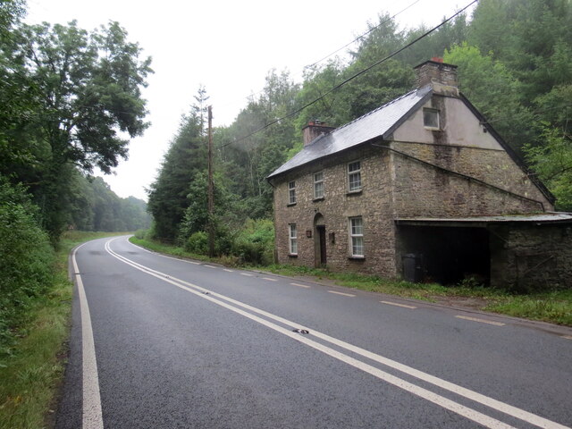
Allt Gell-fain is a picturesque woodland located in the county of Brecknockshire, Wales. Spanning over a vast area, this forested region is renowned for its natural beauty and abundant wildlife.

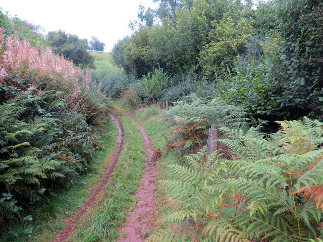
Situated in the southern part of Brecknockshire, Allt Gell-fain is nestled amidst rolling hills and valleys, providing visitors with breathtaking views of the surrounding landscape. The forest is predominantly composed of native tree species, including oak, beech, and birch, which form a dense canopy overhead, creating a serene and tranquil atmosphere.

The woodland is a haven for wildlife enthusiasts, as it is home to a diverse range of fauna. Deer, foxes, and badgers can often be spotted roaming the forest floor, while a variety of bird species, such as woodpeckers and owls, can be observed flitting through the treetops.

Allt Gell-fain offers a number of recreational activities for visitors to enjoy. There are several well-maintained walking trails that wind through the forest, allowing visitors to explore its beauty at their own pace. These trails provide opportunities for nature walks, birdwatching, and photography, making it a popular destination for outdoor enthusiasts.

In addition, the forest is equipped with picnic areas and benches, providing visitors with the perfect spot to relax and enjoy a picnic amidst the natural surroundings. The tranquil atmosphere and stunning scenery make Allt Gell-fain an ideal location for those seeking a peaceful retreat or a day out in nature.

Overall, Allt Gell-fain in Brecknockshire is a captivating woodland destination, offering a unique blend of natural beauty, wildlife, and recreational opportunities for visitors of all ages to enjoy.

If you have any feedback on the listing, please let us know in the comments section below.

Allt Gell-fain Images

Images are sourced within 2km of 51.976342/-3.6784959 or Grid Reference SN8432. Thanks to Geograph Open Source API. All images are credited.

Capel Horeb Chapel, Cwmdwr Adfeilion trist Capel Hermon, addoldy'r Bedyddwyr, Cwmdwr ger Llywel. Adeiladwyd y ty cwrdd cyntaf yn 1820 ac fe'i hailgodwyd bron yn gyfan gwbl yn 1905. Daeth yr achos i ben yn Horeb yng nghanol yr ugeinfed ganrif ac mae e wedi bod yn adfail ers degawdau. Er yn Eglwyswr brwd ymwelydd cyson â'r capel oedd Daniel Owen (Butus, 1795-1886), y dychanwr enwog o bentref Halfway gerllaw. Trist iawn yw meddwl nad oes neb yn dod bellach i ddodi blodau ar feddau anwyliaid. 

The sad remains of Horeb Baptist Chapel, Cwmdwr near Llywel. Built in 1820 it was practically rebuilt in 1905. Closed by the mid 20th century it has been in ruins for many decades. Despite being a staunch Anglican a frequent visitor to the chapel was David Owen (Brutus, 1795-1886), the well known satirist of nearby Halfway. It is sad to think that nobody comes any more to Horeb to put flowers on the graves of loved ones.
Capel Horeb Chapel, Cwmdwr
Adfeilion trist Capel Hermon, addoldy'r Bedyddwyr, Cwmdwr ger Llywel. Adeiladwyd y ty cwrdd cyntaf yn 1820 ac fe'i hailgodwyd bron yn gyfan gwbl yn 1905. Daeth yr achos i ben yn Horeb yng nghanol yr ugeinfed ganrif ac mae e wedi bod yn adfail ers degawdau. Er yn Eglwyswr brwd ymwelydd cyson â'r capel oedd Daniel Owen (Butus, 1795-1886), y dychanwr enwog o bentref Halfway gerllaw. Trist iawn yw meddwl nad oes neb yn dod bellach i ddodi blodau ar feddau anwyliaid. The sad remains of Horeb Baptist Chapel, Cwmdwr near Llywel. Built in 1820 it was practically rebuilt in 1905. Closed by the mid 20th century it has been in ruins for many decades. Despite being a staunch Anglican a frequent visitor to the chapel was David Owen (Brutus, 1795-1886), the well known satirist of nearby Halfway. It is sad to think that nobody comes any more to Horeb to put flowers on the graves of loved ones.
Mynydd Bach Trecastell Cerddwyr o fewn cylch o gerrig o'r Oes Efydd (2000 CC) ar Fynydd Bach Trecastell. Mae dau ddeg saith o gerrig wedi goroesi mas o dri deg. Mae'r cylch yn un o bar. Mae'r un i'r de yn llai o faint. Gerllaw mae Y Pigwn, lleoliad dau wersyll Rhufeinig dros dro cynnar.

Walkers within a Bronze Age (2,000 BC) stone circle on Mynydd Bach Trecastell. Twenty-seven stones have survived from a possible thirty. The circle is one of a pair; the one to the south being substantially smaller. Nearby is Y Pigwn - the site of two early Roman temporary marching camps
Mynydd Bach Trecastell
Cerddwyr o fewn cylch o gerrig o'r Oes Efydd (2000 CC) ar Fynydd Bach Trecastell. Mae dau ddeg saith o gerrig wedi goroesi mas o dri deg. Mae'r cylch yn un o bar. Mae'r un i'r de yn llai o faint. Gerllaw mae Y Pigwn, lleoliad dau wersyll Rhufeinig dros dro cynnar. Walkers within a Bronze Age (2,000 BC) stone circle on Mynydd Bach Trecastell. Twenty-seven stones have survived from a possible thirty. The circle is one of a pair; the one to the south being substantially smaller. Nearby is Y Pigwn - the site of two early Roman temporary marching camps
A 40 at Halfway But from where to where? I have a very vague memory of discussing this nearly 60 years ago while heading west with my parents from Sennybridge to Pembrokeshire. This is the A40 heading up the valley of the Afon Gwydderig.
A 40 at Halfway
But from where to where? I have a very vague memory of discussing this nearly 60 years ago while heading west with my parents from Sennybridge to Pembrokeshire. This is the A40 heading up the valley of the Afon Gwydderig.
Milestone - Brecon 15 There is an Ordnance Survey cut mark on the front of this milestone.
Milestone - Brecon 15
There is an Ordnance Survey cut mark on the front of this milestone.
Capel Horeb / Horeb Chapel Adfeilion trist Capel Hermon, addoldy'r Bedyddwyr, Cwmdwr ger Llywel. Adeiladwyd y ty cwrdd cyntaf yn 1820 ac fe'i hailgodwyd bron yn gyfan gwbl yn 1905. Daeth yr achos i ben yn Horeb yng nghanol yr ugeinfed ganrif ac mae e wedi bod yn adfail ers degawdau. Er yn Eglwyswr brwd ymwelydd cyson â'r capel oedd Daniel Owen (Butus, 1795-1886), y dychanwr enwog o bentref Halfway gerllaw. Trist iawn yw meddwl nad oes neb yn dod bellach i ddodi blodau ar feddau anwyliaid.

The sad remains of Horeb Baptist Chapel, Cwmdwr near Llywel. Built in 1820 it was practically rebuilt in 1905. Closed by the mid 20th century it has been in ruins for many decades. Despite being a staunch Anglican a frequent visitor to the chapel was David Owen (Brutus, 1795-1886), the well known satirist of nearby Halfway. It is sad to think that nobody comes any more to Horeb to put flowers on the graves of loved ones.
Capel Horeb / Horeb Chapel
Adfeilion trist Capel Hermon, addoldy'r Bedyddwyr, Cwmdwr ger Llywel. Adeiladwyd y ty cwrdd cyntaf yn 1820 ac fe'i hailgodwyd bron yn gyfan gwbl yn 1905. Daeth yr achos i ben yn Horeb yng nghanol yr ugeinfed ganrif ac mae e wedi bod yn adfail ers degawdau. Er yn Eglwyswr brwd ymwelydd cyson â'r capel oedd Daniel Owen (Butus, 1795-1886), y dychanwr enwog o bentref Halfway gerllaw. Trist iawn yw meddwl nad oes neb yn dod bellach i ddodi blodau ar feddau anwyliaid. The sad remains of Horeb Baptist Chapel, Cwmdwr near Llywel. Built in 1820 it was practically rebuilt in 1905. Closed by the mid 20th century it has been in ruins for many decades. Despite being a staunch Anglican a frequent visitor to the chapel was David Owen (Brutus, 1795-1886), the well known satirist of nearby Halfway. It is sad to think that nobody comes any more to Horeb to put flowers on the graves of loved ones.
Llwybr ceffyl ger yr A40 / A bridleway near the A40 Llwybr ceffyl yn agosau at yr A40.

A bridleway approaches the A40.
Llwybr ceffyl ger yr A40 / A bridleway near the A40
Llwybr ceffyl yn agosau at yr A40. A bridleway approaches the A40.
Ffordd yr Epynt / Epynt Way Arwyddbost ar Ffordd yr Epynt.

A marker post on the Epynt Way
Ffordd yr Epynt / Epynt Way
Arwyddbost ar Ffordd yr Epynt. A marker post on the Epynt Way
Heol i Dir Abad / Road to Tir Abad Heol yn croesi Mynydd Bwlch y Groes i gyfeiriad Tir Abad.

A road crossing Mynydd Bwlch y Groes (trans. mountain pass of the cross / crossroads) in the direction of Tir Abad (trans. abbot's land).
Heol i Dir Abad / Road to Tir Abad
Heol yn croesi Mynydd Bwlch y Groes i gyfeiriad Tir Abad. A road crossing Mynydd Bwlch y Groes (trans. mountain pass of the cross / crossroads) in the direction of Tir Abad (trans. abbot's land).
Llwybr Ceffyl i lawr o Epynt / Bridleway down from Epynt Llwybr ceffyl yn mynd i lawr i'r cwm o Fynydd Epynt.

A bridleway heading down into the valley from Mynydd Epynt (trans. mountain where horses roam).
Llwybr Ceffyl i lawr o Epynt / Bridleway down from Epynt
Llwybr ceffyl yn mynd i lawr i'r cwm o Fynydd Epynt. A bridleway heading down into the valley from Mynydd Epynt (trans. mountain where horses roam).
Llwybr ceffyl i Ffarm y Bwllfa / Path to Bwllfa Farm Llwybr ceffyl yn mynd i lawr i'r cwm o Fynydd Epynt.

A bridleway heading down to the valley from Mynydd Epynt (trans. mountain where horses roam).
Llwybr ceffyl i Ffarm y Bwllfa / Path to Bwllfa Farm
Llwybr ceffyl yn mynd i lawr i'r cwm o Fynydd Epynt. A bridleway heading down to the valley from Mynydd Epynt (trans. mountain where horses roam).
Llwybr ceffyl ger Bwllfa / Bridleway near Bwllfa Llwybr ceffyl yn agosau at weddillion Ffarm y Bwllfa.

A bridleway approaching the remains of Bwllfa Farm (trans. ditch / hollow).
Llwybr ceffyl ger Bwllfa / Bridleway near Bwllfa
Llwybr ceffyl yn agosau at weddillion Ffarm y Bwllfa. A bridleway approaching the remains of Bwllfa Farm (trans. ditch / hollow).
Ffarm y Bwllfa / Bwllfa Farm Gweddillion un o dai mas Ffarm y Bwllfa.

The remains of an outhouse at Bwllfa Farm (trans. ditch / hollow).
Ffarm y Bwllfa / Bwllfa Farm
Gweddillion un o dai mas Ffarm y Bwllfa. The remains of an outhouse at Bwllfa Farm (trans. ditch / hollow).
Ffarm y Bwllfa / Bwllfa Farm Gweddillion ty ffarm y Bwllfa.

The remains of Bwllfa Farmhouse (trans. ditch / hollow).
Ffarm y Bwllfa / Bwllfa Farm
Gweddillion ty ffarm y Bwllfa. The remains of Bwllfa Farmhouse (trans. ditch / hollow).
Llwybr i'r mynydd / Path to the mountain Llwybr ceffyl yn gadael heol fach ac sy'n mynd i gyfeiriad Mynydd Epynt.

A bridleway exiting a minor road and heading towards Mynydd Epynt (trans. mountain where horses roam).
Llwybr i'r mynydd / Path to the mountain
Llwybr ceffyl yn gadael heol fach ac sy'n mynd i gyfeiriad Mynydd Epynt. A bridleway exiting a minor road and heading towards Mynydd Epynt (trans. mountain where horses roam).
Llwybr ceffyl yng Nghwmdwr / Bridleway at Cwmdwr Llwybr ceffyl yn mynd i lawr y waered tuag at yr A40.

A bridleway descending towards the A40.
Llwybr ceffyl yng Nghwmdwr / Bridleway at Cwmdwr
Llwybr ceffyl yn mynd i lawr y waered tuag at yr A40. A bridleway descending towards the A40.
Hen dafarn y Red Cow / The former Red Cow public house Hen dafarn y Red Cow ar yr A40.

The former Red Cow public house on the A40
Hen dafarn y Red Cow / The former Red Cow public house
Hen dafarn y Red Cow ar yr A40. The former Red Cow public house on the A40
Heol las yng Nghwmdwr / Green lane at Cwmdwr Heol las yn mynd i lawr y waered tuag at yr A40.

A green lane descending towards the A40.
Heol las yng Nghwmdwr / Green lane at Cwmdwr
Heol las yn mynd i lawr y waered tuag at yr A40. A green lane descending towards the A40.
Heol las yng Nghwmdwr / Green lane at Cwmdwr Heol las uwchben yr A40 yng Nghwmdwr.

A green lane above the A40 at Cwmdwr (trans. valley of water).
Heol las yng Nghwmdwr / Green lane at Cwmdwr
Heol las uwchben yr A40 yng Nghwmdwr. A green lane above the A40 at Cwmdwr (trans. valley of water).
Show me another place!

Allt Gell-fain is located at Grid Ref: SN8432 (Lat: 51.976342, Lng: -3.6784959)

Unitary Authority: Powys

Police Authority: Dyfed Powys

What 3 Words

///tender.greeting.kickbacks. Near Llandovery, Carmarthenshire

Related Wikis

Mynydd Bach Trecastell

Mynydd Bach Trecastell is a hill on the border between the counties of Carmarthenshire and Powys in southwest Wales. It lies within the Black Mountain...

Babel, Carmarthenshire

Babel is a village in Carmarthenshire, Wales.

Llywel

Llywel () is a small village located on the A40, about 4 miles (6.4 km) west of Sennybridge in Brecknockshire (currently administered as part of the unitary...

Waun-Ddu

Waun-Ddu is a part of the Mynydd Bach that is a Site of Special Scientific Interest in Carmarthen & Dinefwr, Wales. == See also == List of Sites of Special...

Cwmwysg

Cwmwysg (Welsh for "Usk valley") is a small rural community southwest of Trecastle in the valley of the Usk river, Powys, Wales. It includes the Saron...

Caeau Bronydd-mawr

Caeau Bronydd-mawr is a Site of Special Scientific Interest in Brecknock, Powys, Wales. It is a fen meadow, notable for its contrasting neutral and acid...

Usk Reservoir

The Usk Reservoir (Welsh: Cronfa Wysg) is located in the upper Usk Valley, at 1,006 feet (307 m) above sea level, in the western part of the Brecon Beacons...

Trecastle

Trecastle (Welsh: Trecastell) ("the town of the castle") is a village in Powys, Wales, situated on the edge of the Brecon Beacons National Park (Welsh...

Nearby Amenities

Located within 500m of 51.976342,-3.6784959
Place: farm
Lat/Long: 51.978313/-3.6783235
Ford: yes
Lat/Long: 51.9788637/-3.6735613
Barrier: cattle_grid
Lat/Long: 51.9760381/-3.677226
The data included in this document is from www.openstreetmap.org. The data is made available under ODbL.

Have you been to Allt Gell-fain?

Leave your review of Allt Gell-fain below (or comments, questions and feedback).