Allt Gam-rhiw

Wood, Forest in Brecknockshire

Wales

Allt Gam-rhiw

Babel village hall A new building it seems in this rural area.
Babel village hall Credit: Neil Owen

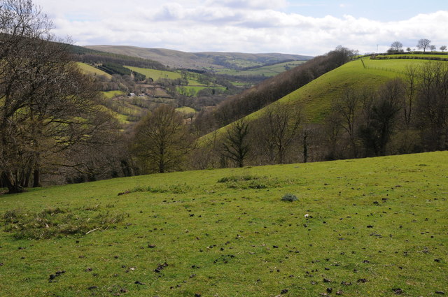
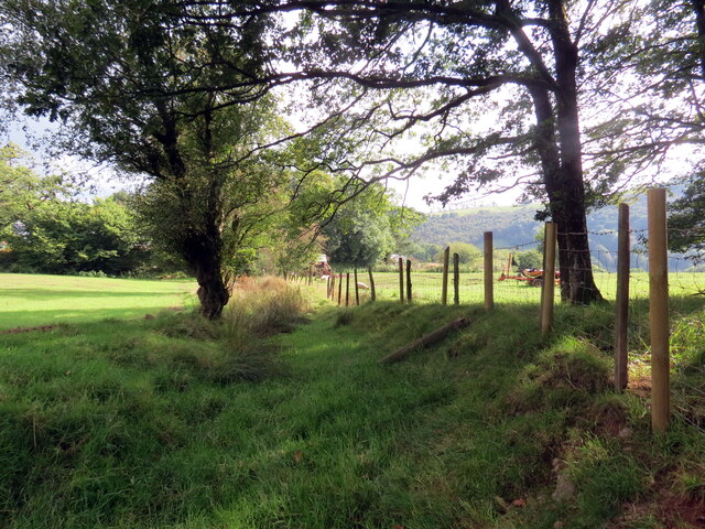
Allt Gam-rhiw is a small forest located in the county of Brecknockshire, Wales. Situated near the village of Sennybridge, the forest covers an area of approximately 100 acres. It is known for its diverse range of flora and fauna, making it a popular destination for nature enthusiasts and hikers.

The forest is predominantly composed of deciduous trees, with species such as oak, beech, and ash being the most prevalent. These trees provide a dense canopy that creates a shaded and cool environment, even during the summer months. The forest floor is covered in a thick layer of leaf litter, which supports a variety of plant life, including ferns, bluebells, and wild mushrooms.

Allt Gam-rhiw is also home to a wide range of wildlife. It is a known habitat for various bird species, such as woodpeckers, nuthatches, and thrushes. Additionally, it is not uncommon to spot mammals like deer, badgers, and foxes within the forest. The presence of these animals adds to the natural beauty and charm of the area.

The forest is crisscrossed with a network of footpaths and trails, making it a popular destination for outdoor activities. Hikers and nature lovers can explore the forest at their own pace, enjoying the peaceful surroundings and breathtaking views. Allt Gam-rhiw offers a tranquil escape from the hustle and bustle of daily life, providing visitors with an opportunity to connect with nature in a serene and serene setting.

If you have any feedback on the listing, please let us know in the comments section below.

Allt Gam-rhiw Images

Images are sourced within 2km of 51.996491/-3.6805169 or Grid Reference SN8434. Thanks to Geograph Open Source API. All images are credited.

Babel village hall A new building it seems in this rural area.
Babel village hall
A new building it seems in this rural area.
Cwm Gwennol View across Cwm Gwennol above Halfway, viewed from a country road near Babel.
Cwm Gwennol
View across Cwm Gwennol above Halfway, viewed from a country road near Babel.
Farmland around Babel View across farmland at Babel with farms of Glyntywarch and Penrhiw in the middle distance.
Farmland around Babel
View across farmland at Babel with farms of Glyntywarch and Penrhiw in the middle distance.
Farm track at Babel Farm track at Babel providing access to farmland at Babel.
Farm track at Babel
Farm track at Babel providing access to farmland at Babel.
Village Hall at Babel
Field above Maes-y-gwaelod Field above Maes-y-gwaelod to the east of Babel.
Field above Maes-y-gwaelod
Field above Maes-y-gwaelod to the east of Babel.
Trees near Maes-y-gwaelod Tree tops beyond a field near Maes-y-gwaelod to the east of Babel.
Trees near Maes-y-gwaelod
Tree tops beyond a field near Maes-y-gwaelod to the east of Babel.
Country road at Babel Country road in a wooded valley at Babel.
Country road at Babel
Country road in a wooded valley at Babel.
View to Troed-y-rhiw View across the valley to Troed-y-rhiw which is just visible through the bare trees.
View to Troed-y-rhiw
View across the valley to Troed-y-rhiw which is just visible through the bare trees.
Llwybr ceffyl ar Fynydd Epynt / Bridleway on Mynydd Epynt Llwybr ceffyl yn agosau at gât ar Fynydd Epynt.

A bridleway approaching a gate on Mynydd Epynt (trans. mountain where horses roam).
Llwybr ceffyl ar Fynydd Epynt / Bridleway on Mynydd Epynt
Llwybr ceffyl yn agosau at gât ar Fynydd Epynt. A bridleway approaching a gate on Mynydd Epynt (trans. mountain where horses roam).
Llwybr ceffyl ar Fynydd Epynt / Bridleway on Mynydd Epynt Llwybr ceffyl yn arwain i lawr o Fynydd Epynt.

A bridleway descending from Mynydd Epynt (trans. mountain where horses roam).
Llwybr ceffyl ar Fynydd Epynt / Bridleway on Mynydd Epynt
Llwybr ceffyl yn arwain i lawr o Fynydd Epynt. A bridleway descending from Mynydd Epynt (trans. mountain where horses roam).
Llwybr ceffyl i Flaen y Cwm / Path to Blaen y Cwm Llwybr ceffyl yn mynd i lawr y waered i gyfeiriad Blaen y Cwm (adfail).

Bridleway descending towards the ruined Blaen y Cwm (trans. head of the valley).
Llwybr ceffyl i Flaen y Cwm / Path to Blaen y Cwm
Llwybr ceffyl yn mynd i lawr y waered i gyfeiriad Blaen y Cwm (adfail). Bridleway descending towards the ruined Blaen y Cwm (trans. head of the valley).
Llwybr ceffyl i Flaen y Cwm / Bridleway to Blaen y Cwm Llwybr ceffyl yn mynd i lawr y waered i gyfeiriad Blaen y Cwm (adfail).

Bridleway descending towards the ruined Blaen y Cwm Farm (trans. head of the valley).
Llwybr ceffyl i Flaen y Cwm / Bridleway to Blaen y Cwm
Llwybr ceffyl yn mynd i lawr y waered i gyfeiriad Blaen y Cwm (adfail). Bridleway descending towards the ruined Blaen y Cwm Farm (trans. head of the valley).
Llwybr ceffyl i Flaen y Cwm / Bridleway to Blaen y Cwm Llwybr ceffyl yn arwain at Flaen y Cwm (adfail).

A bridleway heading towards the ruined Blaen y Cwm Farm (trans. head of the valley).
Llwybr ceffyl i Flaen y Cwm / Bridleway to Blaen y Cwm
Llwybr ceffyl yn arwain at Flaen y Cwm (adfail). A bridleway heading towards the ruined Blaen y Cwm Farm (trans. head of the valley).
Blaen y Cwm Gweddillion Ffarm Blaen y Cwm.

The remains of Blaen y Cwm Farm (trans. head of the valley).
Blaen y Cwm
Gweddillion Ffarm Blaen y Cwm. The remains of Blaen y Cwm Farm (trans. head of the valley).
Llwybr ceffyl Crug-y-Bwbach /  Crug-y-Bwbach bridleway Llwybr ceffyl yn arwain at Ffarm Crug-y-Bwbach.

A bridleway heading towards Crug y Bwbach Farm (trans. mound of the phantom / scarecrow).
Llwybr ceffyl Crug-y-Bwbach / Crug-y-Bwbach bridleway
Llwybr ceffyl yn arwain at Ffarm Crug-y-Bwbach. A bridleway heading towards Crug y Bwbach Farm (trans. mound of the phantom / scarecrow).
Llwybr Crug y Bwbach / Crug y Bwbach path Llwybr ger Ffarm Crug y Bwbach. Hen heol yw hon ond mae hi eisioes wedi ei hisraddio i lwybr troed. Yn anffodus wrth ysgrifennu hwn mae'r ffordd wedi ei rwystro.

A footpath near Crug y Bwbach Farm (trans. mound of the bogy / scarecrow). An old road but it has long been downgraded to a footpath. At the time of writing the path is obstructed.
Llwybr Crug y Bwbach / Crug y Bwbach path
Llwybr ger Ffarm Crug y Bwbach. Hen heol yw hon ond mae hi eisioes wedi ei hisraddio i lwybr troed. Yn anffodus wrth ysgrifennu hwn mae'r ffordd wedi ei rwystro. A footpath near Crug y Bwbach Farm (trans. mound of the bogy / scarecrow). An old road but it has long been downgraded to a footpath. At the time of writing the path is obstructed.
Old track alongside military road
Show me another place!

Allt Gam-rhiw is located at Grid Ref: SN8434 (Lat: 51.996491, Lng: -3.6805169)

Unitary Authority: Powys

Police Authority: Dyfed Powys

What 3 Words

///managers.charts.bats. Near Llandovery, Carmarthenshire

Nearby Locations

Allt Gam-rhiw

Related Wikis

Babel, Carmarthenshire

Babel is a village in Carmarthenshire, Wales.

Mynydd Bach Trecastell

Mynydd Bach Trecastell is a hill on the border between the counties of Carmarthenshire and Powys in southwest Wales. It lies within the Black Mountain...

Crychan Forest Tracks

Crychan Forest Tracks is a Site of Special Scientific Interest in Carmarthen & Dinefwr, Wales. It was chosen as a special stage in the British Rally from...

Waun-Ddu

Waun-Ddu is a part of the Mynydd Bach that is a Site of Special Scientific Interest in Carmarthen & Dinefwr, Wales. == See also == List of Sites of Special...

Nearby Amenities

Located within 500m of 51.996491,-3.6805169
Place: farm
Lat/Long: 52.0001819/-3.6811559
The data included in this document is from www.openstreetmap.org. The data is made available under ODbL.

Have you been to Allt Gam-rhiw?

Leave your review of Allt Gam-rhiw below (or comments, questions and feedback).