Coed Cwmbrân

Wood, Forest in Carmarthenshire

Wales

Coed Cwmbrân

Bwlch Bran, Myddfai Cerddwyr yn gadael llethrau'r mynydd ac yn anelu at Ffarm Bwlch Bran

Walkers leaving the open mountainside and aiming for Bwlch Bran Farm (trans. crow river gap)
Bwlch Bran, Myddfai Credit: Alan Richards

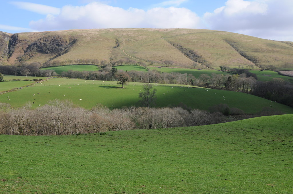
Coed Cwmbrân, located in Carmarthenshire, Wales, is a picturesque woodland that spans over an area of approximately 200 hectares. Situated within the Brechfa Forest, this ancient woodland is renowned for its natural beauty and diverse ecosystem.

The forest is predominantly composed of broadleaf trees, including oak, beech, and ash, which provide a lush canopy overhead. The woodland floor is adorned with a rich carpet of ferns, bluebells, and wildflowers, creating a vibrant and enchanting atmosphere. This natural habitat supports a wide range of wildlife, including various species of birds, small mammals, and insects. Coed Cwmbrân is particularly known for being home to a healthy population of red kites, a majestic bird of prey.

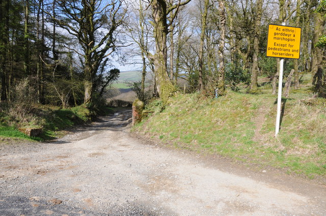
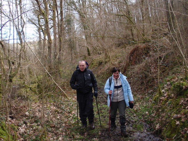
The woodland offers various trails and paths, allowing visitors to explore its beauty on foot or by bicycle. These routes cater to different levels of difficulty, making it accessible for all ages and fitness levels. Additionally, there are picnic areas and benches scattered throughout the forest, providing opportunities for visitors to relax and enjoy the tranquil surroundings.

Coed Cwmbrân is not only a haven for nature enthusiasts but also serves as an important educational and conservation site. The forestry management team ensures sustainable practices are followed, promoting the growth and preservation of the woodland for future generations.

Overall, Coed Cwmbrân is a captivating destination for those seeking to immerse themselves in the natural wonders of Carmarthenshire. With its breathtaking scenery, diverse wildlife, and well-maintained trails, it offers an unforgettable experience for both locals and tourists alike.

If you have any feedback on the listing, please let us know in the comments section below.

Coed Cwmbrân Images

Images are sourced within 2km of 51.968783/-3.7408544 or Grid Reference SN8031. Thanks to Geograph Open Source API. All images are credited.

Bwlch Bran, Myddfai Cerddwyr yn gadael llethrau'r mynydd ac yn anelu at Ffarm Bwlch Bran

Walkers leaving the open mountainside and aiming for Bwlch Bran Farm (trans. crow river gap)
Bwlch Bran, Myddfai
Cerddwyr yn gadael llethrau'r mynydd ac yn anelu at Ffarm Bwlch Bran Walkers leaving the open mountainside and aiming for Bwlch Bran Farm (trans. crow river gap)
Road to Cwm Nant-y-Beudy No through road to Cwm Nant-y-Beudy.
Road to Cwm Nant-y-Beudy
No through road to Cwm Nant-y-Beudy.
Bwlchyrhiw Chapel Bwlchyrhiw Chapel is situation on a quiet country road
Bwlchyrhiw Chapel
Bwlchyrhiw Chapel is situation on a quiet country road
Farmland to the south of Llandovery View across fields to what resemble a motte however it is not marked on the map and I assume it to be spil from quarrying work.
Farmland to the south of Llandovery
View across fields to what resemble a motte however it is not marked on the map and I assume it to be spil from quarrying work.
Except for pedestrians and horses Road closed except for pedestrians and horses.  I assume this right of way which descends into the valley at Pentrebach used to be a passable road for traffic.
Except for pedestrians and horses
Road closed except for pedestrians and horses. I assume this right of way which descends into the valley at Pentrebach used to be a passable road for traffic.
Cwm y Gribin Field and farmland in Cwm y Gribin.
Cwm y Gribin
Field and farmland in Cwm y Gribin.
Farmland above Cwm y Meirch Farmland above Cwm y Meirch with Y Pigwn the high ground beyond.
Farmland above Cwm y Meirch
Farmland above Cwm y Meirch with Y Pigwn the high ground beyond.
Country road above Cwm y Meirch
Road above Halfway Country road above Halfway.
Road above Halfway
Country road above Halfway.
Farmland near Dagfa Farmland near Dagfa and above Halfway.
Farmland near Dagfa
Farmland near Dagfa and above Halfway.
Cwm Esgair Feithgen Cerddwyr yn dilyn llwybr cyhoeddus yng Nghwm Esgair Feithgen.
Walkers following a public footpath in Cwm Esgair Feithgen (grief ridge valley).
Cwm Esgair Feithgen
Cerddwyr yn dilyn llwybr cyhoeddus yng Nghwm Esgair Feithgen. Walkers following a public footpath in Cwm Esgair Feithgen (grief ridge valley).
Sticil ger Ffarm Cwmglyd / Stile near Cwmclyd Farm Llwybr ceffyl yn croesi cae gyda Chraig Cwmclyd yn y pellter.

A bridleway crossing a field with Craig Cwmclyd (trans. sheltered valley crag) in the distance.
Sticil ger Ffarm Cwmglyd / Stile near Cwmclyd Farm
Llwybr ceffyl yn croesi cae gyda Chraig Cwmclyd yn y pellter. A bridleway crossing a field with Craig Cwmclyd (trans. sheltered valley crag) in the distance.
Llwybr Cwmclyd / Cwmclyd path Llwybr ceffyl yn mynd i gyfeiriad Ffarm Cwmclyd.

A bridleway heading towards Cwmclyd Farm (trans. sheltered valley).
Llwybr Cwmclyd / Cwmclyd path
Llwybr ceffyl yn mynd i gyfeiriad Ffarm Cwmclyd. A bridleway heading towards Cwmclyd Farm (trans. sheltered valley).
Heol Rufeinig  / Roman Road Heol hynafol Rufeinig yn mynd i gyfeiriad Mynydd Trecastell lle mae dau gwersyll cyrch yno.

An ancient Roman road heading towards moorland known as Mynydd Trecastell (trans. castle town mountain) and the site of two Roman marching camps.
Heol Rufeinig / Roman Road
Heol hynafol Rufeinig yn mynd i gyfeiriad Mynydd Trecastell lle mae dau gwersyll cyrch yno. An ancient Roman road heading towards moorland known as Mynydd Trecastell (trans. castle town mountain) and the site of two Roman marching camps.
Hen heol las / Old green road Hen heol las yn mynd i gyfeiriad yr A40.

Old green road heading in the direction of the A40
Hen heol las / Old green road
Hen heol las yn mynd i gyfeiriad yr A40. Old green road heading in the direction of the A40
Hen heol ger Allt y Fergwm / Old road near Allt y Fergwm Hen heol ddiwyneb yn mynd i lawr y waered ger Allt y Fergwm. Ar adeg ysgrifennu hwn mae'r ffordd wedi ei rwystro.

Old unsurfaced road descending near Allt y Fergwm (trans. wooded slope of the ?short valley). At the time of writing the road is obstructed.
Hen heol ger Allt y Fergwm / Old road near Allt y Fergwm
Hen heol ddiwyneb yn mynd i lawr y waered ger Allt y Fergwm. Ar adeg ysgrifennu hwn mae'r ffordd wedi ei rwystro. Old unsurfaced road descending near Allt y Fergwm (trans. wooded slope of the ?short valley). At the time of writing the road is obstructed.
Hen heol las / Old green road Hen heol ddiwyneb yn Allt y Dafga. Ar adeg ysgrifennu hwn mae'r ffordd wedi ei rhwystro mewn sawl man.

Old unsurfaced road at Allt y Dagfa. At the time of writing the road is obstructed in several places.
Hen heol las / Old green road
Hen heol ddiwyneb yn Allt y Dafga. Ar adeg ysgrifennu hwn mae'r ffordd wedi ei rhwystro mewn sawl man. Old unsurfaced road at Allt y Dagfa. At the time of writing the road is obstructed in several places.
Terfyn trac coedwigaeth / Limit of forestry track Trac o fewn ffin coedwigaeth ond nid oes modd mynd yn bellach na'r gât yn y pellter gan fod arwydd arni yn gweud tir preifat.

A track just within the boundary of a conifer plantation but there is no access beyond the gate as a sign on it states private land.
Terfyn trac coedwigaeth / Limit of forestry track
Trac o fewn ffin coedwigaeth ond nid oes modd mynd yn bellach na'r gât yn y pellter gan fod arwydd arni yn gweud tir preifat. A track just within the boundary of a conifer plantation but there is no access beyond the gate as a sign on it states private land.
Show me another place!

Coed Cwmbrân is located at Grid Ref: SN8031 (Lat: 51.968783, Lng: -3.7408544)

Unitary Authority: Carmarthenshire

Police Authority: Dyfed Powys

What 3 Words

///plot.blip.conclude. Near Llandovery, Carmarthenshire

Related Wikis

Mynydd Myddfai

Mynydd Myddfai is a hill 4.5 miles southeast of Llandovery in the county of Carmarthenshire, southwest Wales. It lies within the Brecon Beacons National...

Waun-Ddu

Waun-Ddu is a part of the Mynydd Bach that is a Site of Special Scientific Interest in Carmarthen & Dinefwr, Wales. == See also == List of Sites of Special...

Mynydd Bach Trecastell

Mynydd Bach Trecastell is a hill on the border between the counties of Carmarthenshire and Powys in southwest Wales. It lies within the Black Mountain...

Cefn-cerig road

The Cefn-cerig road, a road near Cefn-cerig Farm, Llandovery, Wales, is the location of the Global Boundary Stratotype Section and Point (GSSP) which marks...

Usk Reservoir

The Usk Reservoir (Welsh: Cronfa Wysg) is located in the upper Usk Valley, at 1,006 feet (307 m) above sea level, in the western part of the Brecon Beacons...

Llwynywermod

Llwynywermod (Welsh: Llwynywermwd; Welsh pronunciation: [ɬʊi̯n.ə.wɛr.mʊd]), also known as Llwynywormwood, is an estate owned by the Duchy of Cornwall,...

St Michael's Church, Myddfai

St Michael's Church is the Anglican parish church for the parish of Myddfai, south of Llandovery, in Carmarthenshire, Wales. The present building dates...

Myddfai

Myddfai () is a small village and community in Carmarthenshire, Wales. It is situated south of Llandovery in the Brecon Beacons, and has a population...

Have you been to Coed Cwmbrân?

Leave your review of Coed Cwmbrân below (or comments, questions and feedback).