Gallt y Fron

Wood, Forest in Carmarthenshire

Wales

Gallt y Fron

A40 at Llandovery boundary
A40 at Llandovery boundary Credit: Colin Pyle

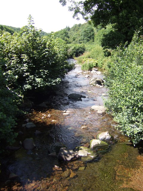
Gallt y Fron is a picturesque woodland located in Carmarthenshire, Wales. Covering an area of approximately 100 acres, the forest is nestled within the rolling hills and valleys of the surrounding countryside. The name "Gallt y Fron" translates to "Wood of the Slope," which accurately describes its location on a gentle slope.

The woodland is predominantly made up of native tree species, including oak, beech, and birch, which provide a diverse and vibrant ecosystem. The dense canopy created by these trees allows little sunlight to penetrate to the forest floor, resulting in a lush understory of ferns, mosses, and wildflowers.

Gallt y Fron is home to a variety of wildlife, offering a haven for birdwatchers and nature enthusiasts. Visitors may spot woodpeckers, red kites, and buzzards soaring above the treetops, while smaller creatures such as squirrels and foxes scurry through the underbrush. The forest also supports a rich diversity of insect life, including butterflies, bees, and beetles.

Several walking trails wind their way through Gallt y Fron, providing visitors with the opportunity to explore the woodland's natural beauty. These paths offer peaceful and tranquil surroundings, allowing visitors to immerse themselves in the sights and sounds of nature. Additionally, there are picnic areas and benches strategically placed throughout the forest, providing a perfect spot to rest and enjoy the serene surroundings.

Overall, Gallt y Fron is a hidden gem in Carmarthenshire, offering a peaceful retreat for those seeking to connect with nature. Its lush woodland, diverse wildlife, and well-maintained trails make it a must-visit destination for outdoor enthusiasts and nature lovers alike.

If you have any feedback on the listing, please let us know in the comments section below.

Gallt y Fron Images

Images are sourced within 2km of 51.982797/-3.7825943 or Grid Reference SN7733. Thanks to Geograph Open Source API. All images are credited.

A40 at Llandovery boundary
Llandovery Castle and Car Park
A4069 at Pont Rhyd-ceir
Erwlon Campsite The setting sun is casting long shadows over Erwlon Campsite just to the east of Llandovery.
Erwlon Campsite
The setting sun is casting long shadows over Erwlon Campsite just to the east of Llandovery.
Camping at Erwlon Campsite A September morning and a heavy dew.
Camping at Erwlon Campsite
A September morning and a heavy dew.
The A40 entering Llandovery The A40, Brecon Road entering Llandovery.
The A40 entering Llandovery
The A40, Brecon Road entering Llandovery.
Houses on Brecon Road Houses on Brecon Road, the A40, the first houses passed when entering Llandovery from the east.
Houses on Brecon Road
Houses on Brecon Road, the A40, the first houses passed when entering Llandovery from the east.
The A40, Brecon Road The A40, Brecon Road leaving Llandovery to the east of the town.
The A40, Brecon Road
The A40, Brecon Road leaving Llandovery to the east of the town.
Footpath and track Track and footpath leading to Maesllydon Hall.
Footpath and track
Track and footpath leading to Maesllydon Hall.
Track and field entrance Track and footpath leading to a Maesllydon Hall.
Track and field entrance
Track and footpath leading to a Maesllydon Hall.
Field on the edge of Llandovery I photographed this field on the eastern edge of Llandovery because there is planning permission for 61 houses on this land.  Next time I am here it may be under under bricks and mortar.
Field on the edge of Llandovery
I photographed this field on the eastern edge of Llandovery because there is planning permission for 61 houses on this land. Next time I am here it may be under under bricks and mortar.
Field beside the A40, Llandovery I photographed this field on the eastern edge of Llandovery because there is planning permission for 61 houses on this land.  Next time I am here it may be under under bricks and mortar.
Field beside the A40, Llandovery
I photographed this field on the eastern edge of Llandovery because there is planning permission for 61 houses on this land. Next time I am here it may be under under bricks and mortar.
Ordnance Survey Flush Bracket 913 This can be found on the parapet wall of Ydw Bridge.
For more detail see : <span class="nowrap"><a title="http://www.bench-marks.org.uk/bm10028" rel="nofollow ugc noopener" href="http://www.bench-marks.org.uk/bm10028">Link</a><img style="margin-left:2px;" alt="External link" title="External link - shift click to open in new window" src="https://s1.geograph.org.uk/img/external.png" width="10" height="10"/></span>
Ordnance Survey Flush Bracket 913
This can be found on the parapet wall of Ydw Bridge. For more detail see : LinkExternal link
Ordnance Survey Flush Bracket 914 This can be found on the wall of a building at Cefn-cerrig.
For more detail see : <span class="nowrap"><a title="http://www.bench-marks.org.uk/bm10029" rel="nofollow ugc noopener" href="http://www.bench-marks.org.uk/bm10029">Link</a><img style="margin-left:2px;" alt="External link" title="External link - shift click to open in new window" src="https://s1.geograph.org.uk/img/external.png" width="10" height="10"/></span>
Ordnance Survey Flush Bracket 914
This can be found on the wall of a building at Cefn-cerrig. For more detail see : LinkExternal link
Broad St Llandovery Broad St runs along one side of the town's war memorial on a small bit of grass and Castle St on the right, runs along the other. Castle Garage forms the third side of a triangle with these streets.
Broad St Llandovery
Broad St runs along one side of the town's war memorial on a small bit of grass and Castle St on the right, runs along the other. Castle Garage forms the third side of a triangle with these streets.
Coloured Houses of West Wales (16) This bright red three-dormer house with what appears to be a plant shop at street level, is at the town centre end of Stone St. in Llandovery.
Coloured Houses of West Wales (16)
This bright red three-dormer house with what appears to be a plant shop at street level, is at the town centre end of Stone St. in Llandovery.
The A40 at Pont Gwydderig Looking west to Llandovery/Llanymddyfri from the lay-by near the bridge.
The A40 at Pont Gwydderig
Looking west to Llandovery/Llanymddyfri from the lay-by near the bridge.
Afon Bran south of Llandovery Castle Taken from the castle early in the morning, looking towards the woods of Allt Dingat
Afon Bran south of Llandovery Castle
Taken from the castle early in the morning, looking towards the woods of Allt Dingat
Show me another place!

Gallt y Fron is located at Grid Ref: SN7733 (Lat: 51.982797, Lng: -3.7825943)

Unitary Authority: Carmarthenshire

Police Authority: Dyfed Powys

What 3 Words

///jots.charts.neatly. Near Llandovery, Carmarthenshire

Nearby Locations

Gallt y Fron

Related Wikis

Cefn-cerig road

The Cefn-cerig road, a road near Cefn-cerig Farm, Llandovery, Wales, is the location of the Global Boundary Stratotype Section and Point (GSSP) which marks...

Afon Gwydderig

The Afon Gwydderig is a tributary of the Afon BrĂ¢n. It rises as the Nant Gwydderig on the southern slopes of Mynydd Bwlch-y-groes, about 3 miles (4.8 km...

Williams Pantycelyn Memorial Chapel, Llandovery

The Williams Pantycelyn Memorial Chapel is a Calvinistic Methodist chapel in the town of Llandovery, Carmarthenshire, Wales. The building was constructed...

Ebenezer Baptist Chapel, Llandovery

Ebenezer Baptist Chapel is a place of worship in the town of Llandovery, Carmarthenshire, Wales. The building was constructed in 1844 and is located at...

Salem Independent Chapel, Llandovery

Salem Independent Chapel is an Independent chapel in the town of Llandovery, Carmarthenshire, Wales. The present building dates from between 1829 and 1830...

Tabernacle Chapel, Llandovery

Tabernacle Chapel is a Calvinistic Methodist chapel in the town of Llandovery, Carmarthenshire, Wales. The present building dates from 1836 and is located...

Llandovery Town Hall

Llandovery Town Hall (Welsh: Neuadd y Dref Llanymddyfri) is a municipal building in Market Street, Llandovery in Carmarthenshire, Wales. The structure...

Llandingat House

Llandingat House is a late Georgian detached town house in the town of Llandovery, Carmarthenshire, Wales. The house was built in the early nineteenth...

Nearby Amenities

Located within 500m of 51.982797,-3.7825943
Power: pole
Transformer: distribution
Lat/Long: 51.9826038/-3.7851414
Power: pole
Lat/Long: 51.9816985/-3.7852809
Power: pole
Lat/Long: 51.980329/-3.7855116
Power: pole
Transformer: distribution
Lat/Long: 51.9794484/-3.7855491
Power: pole
Transformer: distribution
Lat/Long: 51.9856747/-3.7867186
Power: pole
Lat/Long: 51.9852502/-3.784259
Power: pole
Transformer: distribution
Lat/Long: 51.9850899/-3.7831029
Power: pole
Lat/Long: 51.9854319/-3.7824297
Power: pole
Lat/Long: 51.9837833/-3.7850797
Power: pole
Lat/Long: 51.9841566/-3.782486
Power: pole
Transformer: distribution
Lat/Long: 51.984335/-3.7814909
Power: pole
Lat/Long: 51.9852997/-3.7816465
Power: pole
Lat/Long: 51.9858019/-3.7817323
Power: pole
Lat/Long: 51.9869251/-3.7818557
The data included in this document is from www.openstreetmap.org. The data is made available under ODbL.

Have you been to Gallt y Fron?

Leave your review of Gallt y Fron below (or comments, questions and feedback).