Coed Cae-saer

Wood, Forest in Montgomeryshire

Wales

Coed Cae-saer

Gelli-gau, Glaspwll The house of Gelli-gau seen in late afternoon sunlight from the bridleway approaching it.
Gelli-gau, Glaspwll Credit: Mike Parker

Coed Cae-saer, located in Montgomeryshire, is a stunning woodland area known for its natural beauty and rich history. Covering an expansive area, this forest is a popular destination for nature enthusiasts and history buffs alike.

The woodland is abundant with a diverse range of tree species, including oak, ash, beech, and birch. The lush greenery and vibrant foliage make it a picturesque sight throughout the year. The forest floor is adorned with an array of wildflowers and mosses, creating a colorful and serene atmosphere.

Coed Cae-saer is home to a variety of wildlife, providing a habitat for numerous species. Visitors can spot birds such as woodpeckers, owls, and songbirds, as well as mammals like foxes, badgers, and deer. The forest also houses a range of smaller creatures, including squirrels, rabbits, and hedgehogs.

Steeped in history, Coed Cae-saer holds archaeological significance. The area contains ancient burial mounds and remnants of an Iron Age hillfort, highlighting its historical importance. Visitors can explore these remnants and gain insight into the lives of past civilizations.

The forest offers a range of recreational activities for visitors. Hiking and walking trails wind through the woodland, allowing individuals to immerse themselves in the tranquil surroundings. Picnic areas are available for those who wish to enjoy a meal amidst nature.

Overall, Coed Cae-saer in Montgomeryshire is a breathtaking woodland destination, offering a combination of natural beauty, wildlife, and historical significance. Whether seeking relaxation or a chance to delve into the past, this forest provides an unforgettable experience for all who visit.

If you have any feedback on the listing, please let us know in the comments section below.

Coed Cae-saer Images

Images are sourced within 2km of 52.562012/-3.8665405 or Grid Reference SN7397. Thanks to Geograph Open Source API. All images are credited.

Gelli-gau, Glaspwll The house of Gelli-gau seen in late afternoon sunlight from the bridleway approaching it.
Gelli-gau, Glaspwll
The house of Gelli-gau seen in late afternoon sunlight from the bridleway approaching it.
Underneath the larches From the bridleway above the Afon Llyfnant, the colour of the autumnal larch woods seems almost to stain the air.
Underneath the larches
From the bridleway above the Afon Llyfnant, the colour of the autumnal larch woods seems almost to stain the air.
Pompren Llyfnant The footbridge spans not just the lovely Afon Llyfnant, but the counties of Powys (far side) and Ceredigion (near).
Pompren Llyfnant
The footbridge spans not just the lovely Afon Llyfnant, but the counties of Powys (far side) and Ceredigion (near).
Lôn olaf yng Ngheredigion, Glaspwll The Afon Llyfnant is the northernmost border of Ceredigion, so this lane is the last in the county. It was closed to through traffic a decade ago, as it is extremely narrow and the rock face to the right - dripping with ferns and mosses - was considered too risky.
Lôn olaf yng Ngheredigion, Glaspwll
The Afon Llyfnant is the northernmost border of Ceredigion, so this lane is the last in the county. It was closed to through traffic a decade ago, as it is extremely narrow and the rock face to the right - dripping with ferns and mosses - was considered too risky.
Dyffryn Llyfnant Sign at the Glaspwll junction, with the autumn afternoon sun catching the forested peak of Cefn Coch behind. Cwmyrhaiadr farm, down the lane to the left, is now home to the Dyfi Falls pheasant shoot.
Dyffryn Llyfnant
Sign at the Glaspwll junction, with the autumn afternoon sun catching the forested peak of Cefn Coch behind. Cwmyrhaiadr farm, down the lane to the left, is now home to the Dyfi Falls pheasant shoot.
Cwm Rhaiadr The 'rhaiadr' (waterfall) in question is Pistyll y Llyn, which lies a few further miles upstream on the infant Afon Llyfnant. Late autumn afternoon sunshine is being carved into blocks by the slopes and contours of this beautiful, dead-end valley.
Cwm Rhaiadr
The 'rhaiadr' (waterfall) in question is Pistyll y Llyn, which lies a few further miles upstream on the infant Afon Llyfnant. Late autumn afternoon sunshine is being carved into blocks by the slopes and contours of this beautiful, dead-end valley.
Cwm Rhaiadr Taken at the same time and place as <a href="https://www.geograph.org.uk/photo/7340524">SN7496 : Cwm Rhaiadr</a>, looking slightly to the left.
Cwm Rhaiadr
Taken at the same time and place as SN7496 : Cwm Rhaiadr, looking slightly to the left.
Old milestone by Hen Gapel, Derwenlas This classic old Welsh slate milestone stands in front of Hen Gapel, Derwenlas alongside the A487. The top is damaged and it appears to have two lots of inscriptions both apparently indicating 2 miles to Machynlleth. The milestone isn't marked on any maps I've seen, but does appear to be equidistant between milestones 'Mach 1', which is now in a cut off section of the A487 (if the MS exists), and 'Mach 3' further west, which may have been lost to an RTC, where there is a hole in the hedge. 
For a wider view of this milestone see <a href="https://www.geograph.org.uk/photo/7519195">SN7299 : Derwenlas by the A487, and a milestone</a>

Inscription reads:-
         2 M
MA(CH)
2 M.

Surveyed

Milestone Society National ID: MOT_AYMC15
Old milestone by Hen Gapel, Derwenlas
This classic old Welsh slate milestone stands in front of Hen Gapel, Derwenlas alongside the A487. The top is damaged and it appears to have two lots of inscriptions both apparently indicating 2 miles to Machynlleth. The milestone isn't marked on any maps I've seen, but does appear to be equidistant between milestones 'Mach 1', which is now in a cut off section of the A487 (if the MS exists), and 'Mach 3' further west, which may have been lost to an RTC, where there is a hole in the hedge. For a wider view of this milestone see SN7299 : Derwenlas by the A487, and a milestone Inscription reads:- 2 M MA(CH) 2 M. Surveyed Milestone Society National ID: MOT_AYMC15
Derwenlas by the A487, and a milestone Looking west along the A487 in Derwenlas. On the right there is a slate milestone in front of Hen Gapel <a href="https://www.geograph.org.uk/photo/7519171">SN7299 : Old milestone by Hen Gapel, Derwenlas</a>
Derwenlas by the A487, and a milestone
Looking west along the A487 in Derwenlas. On the right there is a slate milestone in front of Hen Gapel SN7299 : Old milestone by Hen Gapel, Derwenlas
A plaque marking the centenary of a death In 2021 it was the centenary of the death of local man Harold Owen Owen in the Abermule train disaster, which is still Britain's worst rail accident. See: <span class="nowrap"><a title="https://en.wikipedia.org/wiki/Abermule_train_collision" rel="nofollow ugc noopener" href="https://en.wikipedia.org/wiki/Abermule_train_collision">Link</a><img style="margin-left:2px;" alt="External link" title="External link - shift click to open in new window" src="https://s1.geograph.org.uk/img/external.png" width="10" height="10"/></span>
A plaque marking the centenary of a death
In 2021 it was the centenary of the death of local man Harold Owen Owen in the Abermule train disaster, which is still Britain's worst rail accident. See: LinkExternal link
The road junction near Glaspwll
An avenue in the trees in Coed Cae'rbobian The name of the wood on the map seems to be an OS typo, as the nearby farm is called Cae'r-bobian.
An avenue in the trees in Coed Cae'rbobian
The name of the wood on the map seems to be an OS typo, as the nearby farm is called Cae'r-bobian.
The road through the trees next to Coed Cae'rbobian The name of the wood on the map seems to be an OS typo, as the nearby farm is called Cae'r-bobian.
The road through the trees next to Coed Cae'rbobian
The name of the wood on the map seems to be an OS typo, as the nearby farm is called Cae'r-bobian.
Luxuriant vegetation on the roadside
Taking the road most travelled The track to the left is a bridleway, but not on today's route plan, which follows the minor road.
Taking the road most travelled
The track to the left is a bridleway, but not on today's route plan, which follows the minor road.
Steep rock, moss and ferns on the road bank It seems that the restricted byway has been carved from the hillside in this area.
Steep rock, moss and ferns on the road bank
It seems that the restricted byway has been carved from the hillside in this area.
A deep trench by the trackside Possibly an old mine working.
A deep trench by the trackside
Possibly an old mine working.
The road below Coed Mynydd Eithaf
Show me another place!

Coed Cae-saer is located at Grid Ref: SN7397 (Lat: 52.562012, Lng: -3.8665405)

Unitary Authority: Powys

Police Authority: Dyfed Powys

What 3 Words

///repaying.distorts.tutored. Near Machynlleth, Powys

Related Wikis

Derwenlas

Derwenlas is a hamlet in northern Powys, Wales. It is part of the community of Cadfarch. Part of the historic county of Montgomeryshire (Sir Drefaldwyn...

Machynlleth transmitting station

The Machynlleth transmitting station is a broadcasting and telecommunications facility located on a hill about 2.5 kilometres (1.6 mi) west of the town...

Morben

Morben is a hamlet in northern Powys, Wales. Part of the historic county of Montgomeryshire (Sir Drefaldwyn) from 1536 to 1974, it lies on the Afon Dyfi...

Plas Machynlleth

Plas Machynlleth is the former Welsh residence of the Marquesses of Londonderry. It is situated in the market town of Machynlleth in Powys (formerly Montgomeryshire...

Machynlleth F.C.

Machynlleth Football Club (Welsh: Clwb Pêl Droed Machynlleth) is a Welsh football team based in Machynlleth, Powys, Wales. They played in the Ardal Leagues...

Celtica (visitor centre)

Celtica was an educational guest centre located in Machynlleth, Wales. Formed in 1995, Celtica provided domestic and foreign tourists with information...

Ysgol Bro Hyddgen

Ysgol Bro Hyddgen is a bilingual, all-age (4-19) school situated in Machynlleth, Powys. The school is a combination of two previous schools, namely Machynlleth...

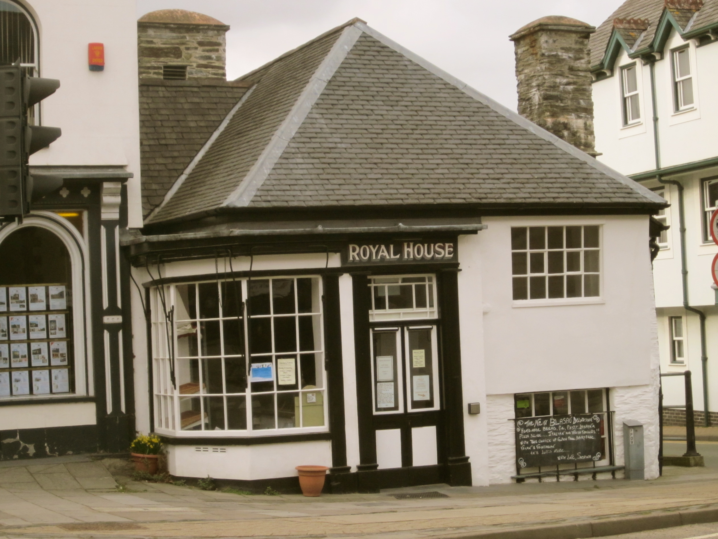
Royal House, Machynlleth

The Royal House in Machynlleth is a 16th-century merchant’s house with extensive interior timber framing, clad in stone on the outside, with two massive...

Nearby Amenities

Located within 500m of 52.562012,-3.8665405
Place: farm
Lat/Long: 52.5619827/-3.862595
Place: farm
Lat/Long: 52.5634045/-3.870706
The data included in this document is from www.openstreetmap.org. The data is made available under ODbL.

Have you been to Coed Cae-saer?

Leave your review of Coed Cae-saer below (or comments, questions and feedback).