Allt Tan-caebanal

Wood, Forest in Cardiganshire

Wales

Allt Tan-caebanal

Roadside figures near Penuwch Not really sure what these are, they have been photographed <a href="https://www.geograph.org.uk/photo/2583385">SN6063 : Roadside figures near Penuwch</a>.
Roadside figures near Penuwch Credit: Philip Halling

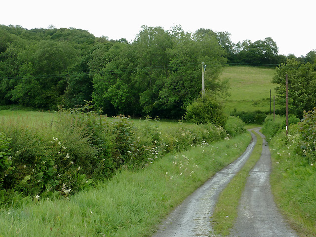
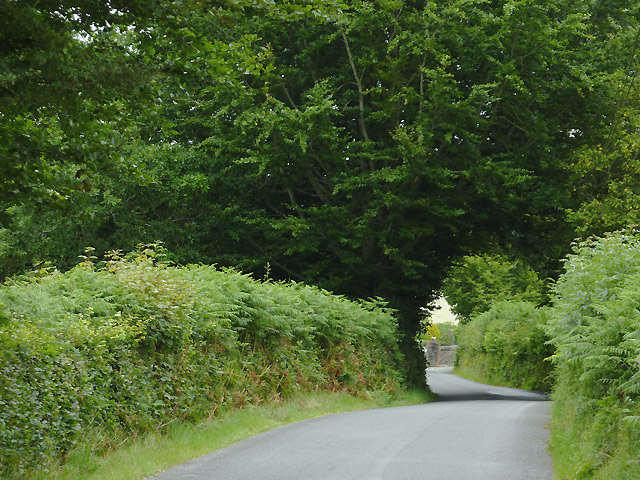
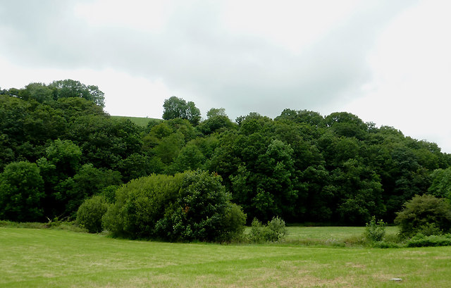
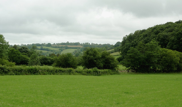
Allt Tan-caebanal is a wooded area located in Cardiganshire, Wales. It is known for its lush and diverse forest, which covers a vast expanse of land. The woodland is situated on a steep slope, offering stunning views of the surrounding landscape.

The forest is primarily composed of deciduous trees such as oak, beech, and ash, but it also contains coniferous trees like pine and spruce. This mix of tree species creates a rich and varied ecosystem, providing habitat for a wide range of wildlife. Visitors to Allt Tan-caebanal may spot various bird species, including woodpeckers and owls, as well as mammals like deer and foxes.

The woodland is traversed by a network of walking trails, allowing visitors to explore its beauty at their own pace. These paths wind through the forest, leading to hidden clearings and babbling streams. The peaceful atmosphere and the sound of birdsong make it a perfect destination for nature enthusiasts and those seeking a tranquil escape from the hustle and bustle of everyday life.

Allt Tan-caebanal is also an important site for conservation efforts, with ongoing initiatives to protect and preserve its natural beauty. Local authorities work closely with environmental organizations to maintain the delicate balance of the ecosystem and ensure the long-term sustainability of this woodland.

In conclusion, Allt Tan-caebanal in Cardiganshire is a picturesque and ecologically significant forest. With its diverse tree species, abundant wildlife, and well-maintained trails, it offers a delightful experience for nature lovers and a valuable resource for conservation.

If you have any feedback on the listing, please let us know in the comments section below.

Allt Tan-caebanal Images

Images are sourced within 2km of 52.231449/-4.0334314 or Grid Reference SN6161. Thanks to Geograph Open Source API. All images are credited.

Roadside figures near Penuwch Not really sure what these are, they have been photographed <a href="https://www.geograph.org.uk/photo/2583385">SN6063 : Roadside figures near Penuwch</a>.
Roadside figures near Penuwch
Not really sure what these are, they have been photographed SN6063 : Roadside figures near Penuwch.
Farm track north-east of Llangeitho, Ceredigion The bridleway along this track leads up Cwm Coch to the Llanbadarn Odwyn church on the hill, and onward to Sarn Helen (B4578) at Deri Odwen farm.
Farm track north-east of Llangeitho, Ceredigion
The bridleway along this track leads up Cwm Coch to the Llanbadarn Odwyn church on the hill, and onward to Sarn Helen (B4578) at Deri Odwen farm.
Lane north-east of Llangeitho, Ceredigion The lane leads towards the head of the Aeron Valley, and the B4578 near Tyncelyn.
Lane north-east of Llangeitho, Ceredigion
The lane leads towards the head of the Aeron Valley, and the B4578 near Tyncelyn.
Pasture and woodland by the Afon Aeron near Llangeitho, Ceredigion The river flows from right to left by the bushes in the middle of the image.
Pasture and woodland by the Afon Aeron near Llangeitho, Ceredigion
The river flows from right to left by the bushes in the middle of the image.
Upper Aeron Valley, Ceredigion The valley widens here north-east of Llangeitho, and contains rich pasture land for many miles.
Upper Aeron Valley, Ceredigion
The valley widens here north-east of Llangeitho, and contains rich pasture land for many miles.
Roadside figures near Penuwch These figures in a roadside field near Penuwch make a diverting and distracting sight when passing in the car. They stand as if acting out a particular scenario or tableau, frozen in time and you aren't sure what you're seeing, or even if you really saw what you thought you saw and so on. So I executed a safe u-turn and came back to investigate. What are they made from? By whom? For what purpose? A prank? How old are they? What story do they tell? What do they represent? What is their scrap value??
Roadside figures near Penuwch
These figures in a roadside field near Penuwch make a diverting and distracting sight when passing in the car. They stand as if acting out a particular scenario or tableau, frozen in time and you aren't sure what you're seeing, or even if you really saw what you thought you saw and so on. So I executed a safe u-turn and came back to investigate. What are they made from? By whom? For what purpose? A prank? How old are they? What story do they tell? What do they represent? What is their scrap value??
Roadside figures near Penuwch On closer investigation I discovered that they are made of fibreglass, painted to resemble bronze. One male figure may be a king, as he wears what appears to be a crown. What sort of king? A gypsy king? His lady, or possibly queen(?) appears to be carrying a pot of paint, or a handbag resembling a paintpot. The fibreglass pony has a docked tail and wears swimming goggles. And appears to be deep in conversation with the humans. Are they horse-traders? Have I had too much coffee? Why is my attention span getting so poor? Prompting more questions than they answer, these figures are a wonderful roadside conundrum.
Roadside figures near Penuwch
On closer investigation I discovered that they are made of fibreglass, painted to resemble bronze. One male figure may be a king, as he wears what appears to be a crown. What sort of king? A gypsy king? His lady, or possibly queen(?) appears to be carrying a pot of paint, or a handbag resembling a paintpot. The fibreglass pony has a docked tail and wears swimming goggles. And appears to be deep in conversation with the humans. Are they horse-traders? Have I had too much coffee? Why is my attention span getting so poor? Prompting more questions than they answer, these figures are a wonderful roadside conundrum.
Roadside figures near Penuwch The key to the mystery of the figures lies on the faded and weathered plaque in Welsh. Apparently they were made in 1993 by the children of the local school. They have weathered well. And possibly have survived attempted kidnapping attempts one would think...Not a traffic cone in sight. I hope to see more baffling roadside figures at various remote points in future. (On a serious note; the standard of the figures is very good and I trust that at least a few of the class of '93 that did these went on to study sculpture).
Roadside figures near Penuwch
The key to the mystery of the figures lies on the faded and weathered plaque in Welsh. Apparently they were made in 1993 by the children of the local school. They have weathered well. And possibly have survived attempted kidnapping attempts one would think...Not a traffic cone in sight. I hope to see more baffling roadside figures at various remote points in future. (On a serious note; the standard of the figures is very good and I trust that at least a few of the class of '93 that did these went on to study sculpture).
Llidiart-maen-gwyn from B4577
Turning for Llangeitho
Figures in field near Penuwch Fibreglass figures made by pupils at local school
Figures in field near Penuwch
Fibreglass figures made by pupils at local school
Entrance sign to Gelli Angharad Next to field with the figures
Entrance sign to Gelli Angharad
Next to field with the figures
Roadside figures at Penuwch
Figures and description tablet by roadside
Road junction at Llidiart-maen-gwyn The back road to Llangeitho leaves the B4577.
Road junction at Llidiart-maen-gwyn
The back road to Llangeitho leaves the B4577.
Minor road heading for Capel Betws Leucu Crossing uplands before dropping down to the Aeron valley.
Minor road heading for Capel Betws Leucu
Crossing uplands before dropping down to the Aeron valley.
Road heading downhill Part of the link between Penuwch and Llangeitho.
Road heading downhill
Part of the link between Penuwch and Llangeitho.
Show me another place!

Allt Tan-caebanal is located at Grid Ref: SN6161 (Lat: 52.231449, Lng: -4.0334314)

Unitary Authority: Ceredigion

Police Authority: Dyfed Powys

What 3 Words

///replaying.maternal.bedrock. Near Tregaron, Ceredigion

Nearby Locations

Allt Tan-caebanal

Related Wikis

Llangeitho

Llangeitho is a village and community on the upper River Aeron in Ceredigion, Wales, about four miles (6 km) west of Tregaron and 11 kilometres (7 mi)...

Penuwch

Penuwch is a rural village in Ceredigion, Wales. Penuwch is about 1,000 feet above sea level and 8 miles west of Tregaron while the coast is a similar...

Capel Betws Lleucu

Capel Betws Lleucu is a hamlet in Cardiganshire, Wales.SY postcode area SY 25 6 SN606583 == References == == External links == http://www.accuweather.com/en/gb/capel...

Crynfryn

Crynfryn is a hamlet bach in the community of Nantcwnlle, Ceredigion, Wales, which is 64.6 miles (104 km) from Cardiff and 175.7 miles (282.8 km) from...

Have you been to Allt Tan-caebanal?

Leave your review of Allt Tan-caebanal below (or comments, questions and feedback).