Coed y Grip

Wood, Forest in Cardiganshire

Wales

Coed y Grip

Capel Tabor o fynwent yr eglwys / Capel Tabor from the church graveyard
Capel Tabor o fynwent yr eglwys / Capel Tabor from the church graveyard Credit: Ceri Thomas

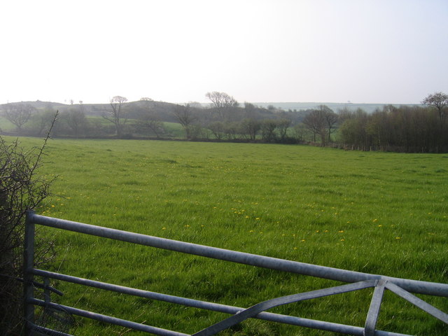
Coed y Grip is a picturesque woodland located in Cardiganshire, Wales. Covering an area of approximately 100 acres, this forest is a haven for nature enthusiasts and outdoor lovers alike. The woodland is situated in a hilly region, offering visitors stunning views of the surrounding landscape.

Coed y Grip is predominantly composed of deciduous trees, including oak, ash, and beech, which create a diverse and vibrant ecosystem. The forest floor is rich with a variety of wildflowers, ferns, and mosses, adding to the enchanting atmosphere. A network of well-maintained footpaths and trails allows visitors to explore the woodland and discover its hidden treasures.

The forest is home to a wide range of wildlife, providing a sanctuary for many species. Visitors may catch glimpses of various bird species, such as woodpeckers, owls, and jays, as well as small mammals like squirrels and foxes. The woodlands also host a diverse insect population, attracting butterfly and dragonfly enthusiasts.

Coed y Grip offers more than just natural beauty. It features several picnic areas and benches, providing visitors with the opportunity to relax and enjoy a meal amidst the serene surroundings. Additionally, the forest is a popular destination for walkers, joggers, and cyclists who can take advantage of the well-marked paths.

Coed y Grip is a true gem in the heart of Cardiganshire, offering visitors a chance to immerse themselves in nature's tranquility. Whether it be exploring the woodland trails, observing wildlife, or simply enjoying a picnic, this forest is a must-visit destination for anyone seeking solace in the beauty of the natural world.

If you have any feedback on the listing, please let us know in the comments section below.

Coed y Grip Images

Images are sourced within 2km of 52.314646/-4.0851613 or Grid Reference SN5770. Thanks to Geograph Open Source API. All images are credited.

Capel Tabor o fynwent yr eglwys / Capel Tabor from the church graveyard
Arwydd pentref Llangwyryfon / Llangwyryfon village sign This sign still retains its raised lettering.
Arwydd pentref Llangwyryfon / Llangwyryfon village sign
This sign still retains its raised lettering.
Esgair farm
Esgair farm
Ger Penbanc / Near Penbanc Caeau ger Penbanc gyda Fferm Gwynt Llangwyryfon ar y gorwel / Fields near Penbanc with Llangwyryfon Winfarm on the horizon.
Ger Penbanc / Near Penbanc
Caeau ger Penbanc gyda Fferm Gwynt Llangwyryfon ar y gorwel / Fields near Penbanc with Llangwyryfon Winfarm on the horizon.
Hen gapel /  Old Chapel Tynnais i lun o'r capel hwn o bell 'nol yn 2007 <a href="https://www.geograph.org.uk/photo/400334">SN5769 : Hen Gapel ger Llangwyryfon / Old Chapel near Llangwyryfon</a> ac mae'n amlwg ei fod wedi dirywio yn sylweddol bellach / I took a photo of this chapel back in 2007 <a href="https://www.geograph.org.uk/photo/400334">SN5769 : Hen Gapel ger Llangwyryfon / Old Chapel near Llangwyryfon</a> and it is clear that by now it has substantially deteriorated.
Hen gapel / Old Chapel
Tynnais i lun o'r capel hwn o bell 'nol yn 2007 SN5769 : Hen Gapel ger Llangwyryfon / Old Chapel near Llangwyryfon ac mae'n amlwg ei fod wedi dirywio yn sylweddol bellach / I took a photo of this chapel back in 2007 SN5769 : Hen Gapel ger Llangwyryfon / Old Chapel near Llangwyryfon and it is clear that by now it has substantially deteriorated.
Tyndderwen a Thynwern / Tyndderwen and Tynwern Ffermydd ger Llangwyryfon/ Farms near Llangwyryfon.
Tyndderwen a Thynwern / Tyndderwen and Tynwern
Ffermydd ger Llangwyryfon/ Farms near Llangwyryfon.
Ger Bryn Gwyn / Near Bryn Gwyn Lon wledig rhwng Llangwyryfon a Llanrhystud / Country lane between Llangwyryfon a Llanrhystud
Ger Bryn Gwyn / Near Bryn Gwyn
Lon wledig rhwng Llangwyryfon a Llanrhystud / Country lane between Llangwyryfon a Llanrhystud
Eglwys S. Ursula Llangwyryfon One of only two churches in Europe to be dedicated to St.Ursula and the 11000 Virgins, the other being in Cologne, Germany.

"According to legend, Saint Ursula and her handmaidens made a pilgrimage by sea from Britain to Rome.  The voyage took three years, and they were blown off course to many strange places.  Finally, they arrived at the Rhine River. When Saint Ursula refused to marry a Hun chieftain, she and her companions were martyred in Cologne around 500 A.D. As this story was retold, the number of martyred virgins grew from 11 to 11,000, perhaps in part due to a mistranslation of the story."
Eglwys S. Ursula Llangwyryfon
One of only two churches in Europe to be dedicated to St.Ursula and the 11000 Virgins, the other being in Cologne, Germany. "According to legend, Saint Ursula and her handmaidens made a pilgrimage by sea from Britain to Rome. The voyage took three years, and they were blown off course to many strange places. Finally, they arrived at the Rhine River. When Saint Ursula refused to marry a Hun chieftain, she and her companions were martyred in Cologne around 500 A.D. As this story was retold, the number of martyred virgins grew from 11 to 11,000, perhaps in part due to a mistranslation of the story."
Cemetery at Llangwyryfon
Country lane near Llangwyryfon Early morning mist formed at sunrise after skies cleared from a very wet night. Taken above sharp bend on a unclassified road between Llangwyryfon and Llanrhystud.
Country lane near Llangwyryfon
Early morning mist formed at sunrise after skies cleared from a very wet night. Taken above sharp bend on a unclassified road between Llangwyryfon and Llanrhystud.
Waterlogged Field Edge Waterlogged hollow on field boundary on north side of lane near Llangwyryfon
Waterlogged Field Edge
Waterlogged hollow on field boundary on north side of lane near Llangwyryfon
Coed y Grip Dyma goedwig coniferaidd yng Ngwm Wyre,ger Llangwyryfon,yn y gaeaf.

Here is a coniferous woodland in the Wyre Valley near Llangwyryfon
Coed y Grip
Dyma goedwig coniferaidd yng Ngwm Wyre,ger Llangwyryfon,yn y gaeaf. Here is a coniferous woodland in the Wyre Valley near Llangwyryfon
Bryngwyn Tir amaethyddol ger Bryngwyn
Agricultural Land near Bryngwyn
Bryngwyn
Tir amaethyddol ger Bryngwyn Agricultural Land near Bryngwyn
Country lane near Pencwmcanol Lôn gul a thir amaethyddol ger Pencwmcanol
Country lane in farmland near Pencwmcanol
Country lane near Pencwmcanol
Lôn gul a thir amaethyddol ger Pencwmcanol Country lane in farmland near Pencwmcanol
Narrow lane Lôn gul a serth ar bwys fforest ar lethrau serth Cwm Wyre
Steep narrow lane with forest on steep side of Cwm Wyre
Narrow lane
Lôn gul a serth ar bwys fforest ar lethrau serth Cwm Wyre Steep narrow lane with forest on steep side of Cwm Wyre
Afon Carrog Cwm agored Afon Carrog ger Fferm Blaencarrog

Broad valley of the Afon Carrog near Blaencarrog Farm
Afon Carrog
Cwm agored Afon Carrog ger Fferm Blaencarrog Broad valley of the Afon Carrog near Blaencarrog Farm
Lon wledig / Country Lane Dyma lon wledig rhwng Llangwyryfon a Trefenter / Country Lane between Llangwyryfon and Trefenter
Lon wledig / Country Lane
Dyma lon wledig rhwng Llangwyryfon a Trefenter / Country Lane between Llangwyryfon and Trefenter
Tir Amaethyddol gyferbyn Ty Cam / Farmland opposite to Ty Cam Tir Amaethyddol gyferbyn Ty Cam ger Llangwyryfon / Farmland opposite to Ty Cam near Llangwyryfon
Tir Amaethyddol gyferbyn Ty Cam / Farmland opposite to Ty Cam
Tir Amaethyddol gyferbyn Ty Cam ger Llangwyryfon / Farmland opposite to Ty Cam near Llangwyryfon
Show me another place!

Coed y Grip is located at Grid Ref: SN5770 (Lat: 52.314646, Lng: -4.0851613)

Unitary Authority: Ceredigion

Police Authority: Dyfed Powys

What 3 Words

///solicitor.rafters.ignites. Near Llanilar, Ceredigion

Nearby Locations

Coed y Grip

Related Wikis

Llangwyryfon

Llangwyryfon is a village and community in the county of Ceredigion, Wales. It lies on the B4576 about 8 miles to the south and east of Aberystwyth. The...

Rhos Blaen Carrog

Rhos Blaen Carrog is a Site of Special Scientific Interest in Ceredigion, west Wales, due to its population of Wavy St. John's Wort (Hypericum undulatum...

Gaer Penrhôs

Gaer Penrhôs, in Ceredigion, Wales, was a ringwork castle at the summit of a steep hill near the village of Llanrhystud; now all that remains are the outlines...
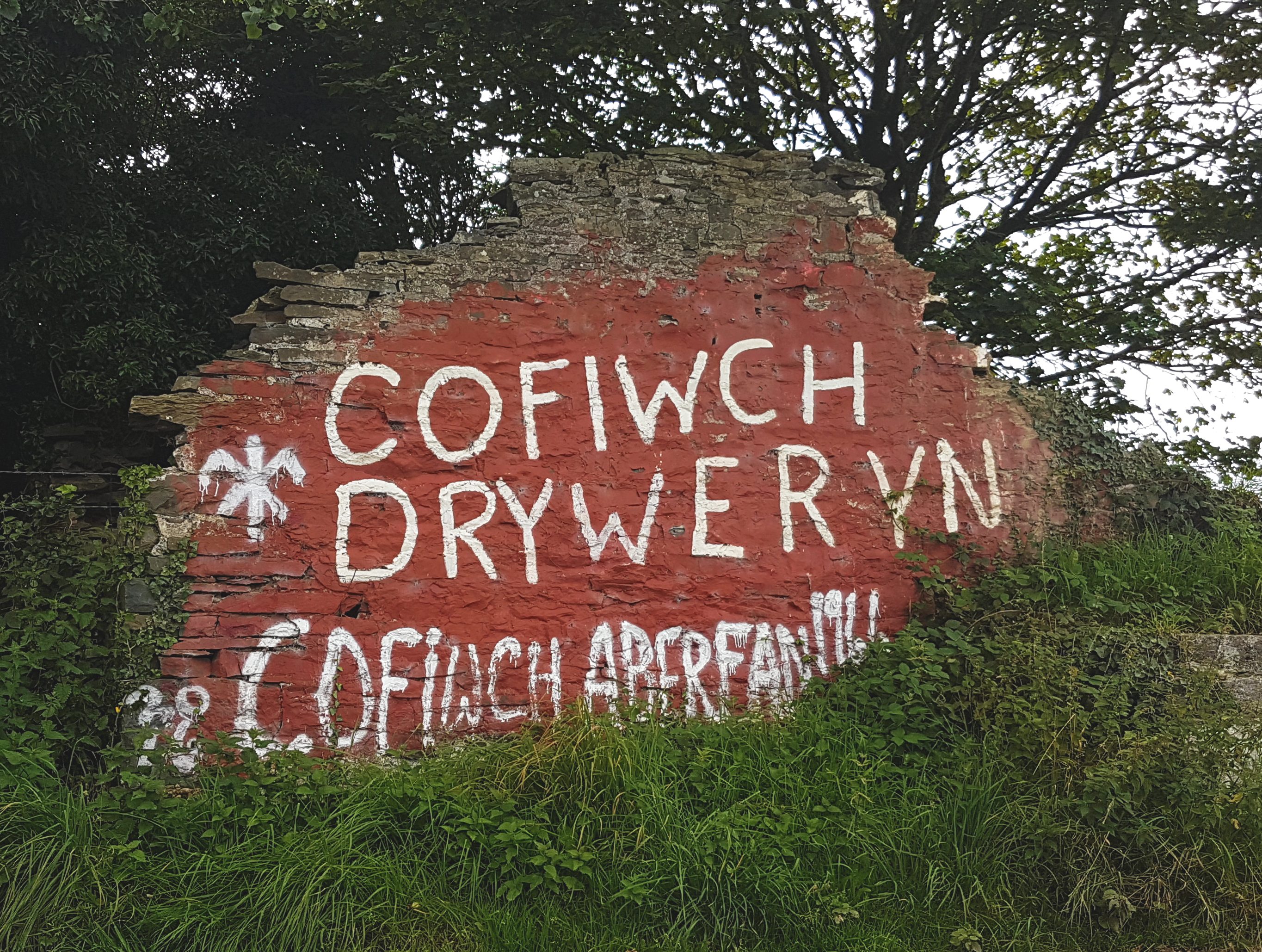
Cofiwch Dryweryn

Cofiwch Dryweryn (Welsh for 'Remember Tryweryn') is a graffitied stone wall near Llanrhystud, Ceredigion, Wales. Author and journalist Meic Stephens originally...

Nearby Amenities

Located within 500m of 52.314646,-4.0851613
Place: farm
Lat/Long: 52.3114166/-4.0843382
Direction: 185
Generator Method: photovoltaic
Generator Output Electricity: yes
Generator Solar Modules: 16
Generator Source: solar
Generator Type: solar_photovoltaic_panel
Location: roof
Power: generator
Lat/Long: 52.3108688/-4.0845189
The data included in this document is from www.openstreetmap.org. The data is made available under ODbL.

Have you been to Coed y Grip?

Leave your review of Coed y Grip below (or comments, questions and feedback).