Allt Lan-las

Wood, Forest in Cardiganshire

Wales

Allt Lan-las

Llanerchaeron House and Garden: Field of buttercups seen from the lake
Llanerchaeron House and Garden: Field of buttercups seen from the lake Credit: Michael Garlick

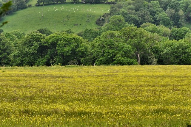
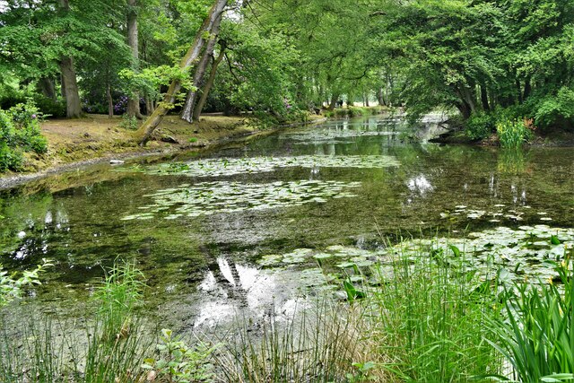
Allt Lan-las is a picturesque woodland located in the county of Cardiganshire, Wales. It is nestled in the heart of the beautiful countryside, offering a haven of tranquility and natural beauty. With an area spanning approximately 100 hectares, it is a significant forested area in the region.

The woodland is characterized by a diverse range of trees, including oak, ash, and beech, which create a dense canopy overhead. This provides a sheltered habitat for a variety of wildlife, such as birds, squirrels, and deer, making it a popular spot for nature enthusiasts and birdwatchers.

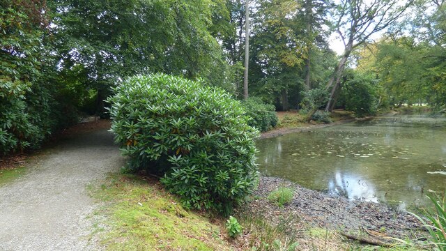
Visitors can explore the forest through a network of well-maintained footpaths and trails, allowing for leisurely walks and immersive experiences in nature. The terrain is undulating, with some parts offering stunning panoramic views of the surrounding landscape.

Allt Lan-las is also known for its rich history. The woodland has evidence of ancient settlements, with remnants of Iron Age settlements and burial mounds scattered throughout the area. These historical features add an extra layer of intrigue and fascination for those interested in the region's past.

The forest is easily accessible, with nearby parking facilities and public transportation links. It is a popular destination for locals and tourists alike, providing a peaceful retreat from the hustle and bustle of everyday life.

Overall, Allt Lan-las is a captivating woodland that offers a unique blend of natural beauty, wildlife, and historical significance. Whether seeking solace in nature or delving into the region's past, this wood in Cardiganshire is a must-visit destination.

If you have any feedback on the listing, please let us know in the comments section below.

Allt Lan-las Images

Images are sourced within 2km of 52.221686/-4.2279453 or Grid Reference SN4760. Thanks to Geograph Open Source API. All images are credited.

Llanerchaeron House and Garden: Field of buttercups seen from the lake
Llanerchaeron House and Garden: View from the eastern end of the lake
Path and pond at Llanerchaeron
Llanerchaeron House and Garden: Fireplace in the study
Llanerchaeron House and Garden: Bookcase in the study
Llanerchaeron House and Garden: Badger
Llanerchaeron House and Garden: Stairs leading to the first floor
Llanerchaeron House and Garden: The dome
Llanerchaeron House and Garden: Bedroom
Llanerchaeron House and Garden: Bedroom dressing table
Llanerchaeron House and Garden: Washing requisites
Llanerchaeron House and Garden: Rest room with sink
Llanerchaeron House and Garden: Display of crockery in the kitchen
Llanerchaeron House and Garden: Kitchen
Llanerchaeron House and Garden: Kitchen range
Llanerchaeron House and Garden: Scullery
Show me another place!

Allt Lan-las is located at Grid Ref: SN4760 (Lat: 52.221686, Lng: -4.2279453)

Unitary Authority: Ceredigion

Police Authority: Dyfed Powys

What 3 Words

///washing.polishing.modem. Near Aberaeron, Ceredigion

Related Wikis

Llanerchaeron

Llanerchaeron, known as "Llanayron House" to its nineteenth-century occupants, is a grade I listed mansion on the River Aeron, designed and built in 1795...

Llanerch-Ayron Halt railway station

Llanerch-Ayron Halt was a small railway station on the Aberayron branch of the Carmarthen to Aberystwyth Line in the Welsh county of Ceredigion serving...

Crossways Halt railway station

Crossways Halt was a small railway station on the Aberayron branch of the Carmarthen to Aberystwyth Line in the Welsh county of Ceredigion serving the...

Tŷ Glyn

Tŷ Glyn or Tyglyn is a small village in the community of Ciliau Aeron, Ceredigion, Wales, which is 67.1 miles (107.9 km) from Cardiff and 180.5 miles...

Dinerth Castle

The Castle of Dinerth (Welsh: Castell Dineirth, Castell Dinerth, or Castell Allt Craig Arth) is a Welsh castle located near Aberarth, Ceredigion, west...

Ysgol Gyfun Aberaeron

Ysgol Gyfun Aberaeron is a bilingual comprehensive school for pupils aged between 11 and 18 years. The school is situated in the town of Aberaeron in Ceredigion...

Ciliau Aeron

Ciliau Aeron (English: where the valley of the river Aeron narrows) is a community and small village 4 miles from Aberaeron in Ceredigion, Wales on the...

Aberayron railway station

Aberayron railway station in Aberaeron was the terminus of the Lampeter, Aberayron and New Quay Light Railway branch line of the Carmarthen to Aberystwyth...

Nearby Amenities

Located within 500m of 52.221686,-4.2279453
Source: npe
Lat/Long: 52.2212638/-4.234796
Source: npe
Lat/Long: 52.2208039/-4.2322942
Source: npe
Lat/Long: 52.221217/-4.2308059
Source: npe
Lat/Long: 52.2197557/-4.2268562
Source: npe
Lat/Long: 52.2199473/-4.2251335
Source: npe
Lat/Long: 52.2192281/-4.2236254
Source: npe
Lat/Long: 52.2197187/-4.2213589
Parking
Parking: surface
Lat/Long: 52.2192267/-4.2254124
Bench
Backrest: yes
Source: photograph
Lat/Long: 52.2188944/-4.2260941
Access: foot
Barrier: door
Lat/Long: 52.2183733/-4.224612
Access: foot
Barrier: door
Lat/Long: 52.2183335/-4.2252536
Bench
Backrest: yes
Source: photograph
Lat/Long: 52.2188581/-4.2260019
Toilets
Fixme: GPX quality low, too many trees on bing :(
Source: photograph
Lat/Long: 52.2192075/-4.2274876
Bench
Backrest: yes
Source: photograph
Lat/Long: 52.2189578/-4.2269012
Bench
Backrest: yes
Source: photograph
Lat/Long: 52.2188411/-4.2255039
Bench
Backrest: yes
Source: photograph
Lat/Long: 52.2189102/-4.226282
Bench
Backrest: yes
Source: photograph
Lat/Long: 52.218838/-4.2257668
Entrance: yes
Lat/Long: 52.2187392/-4.2277762
Access: foot
Barrier: door
Fee: yes
Lat/Long: 52.2184266/-4.2259173
Bench
Backrest: yes
Source: photograph
Lat/Long: 52.2188383/-4.2256427
Toilets
Lat/Long: 52.2194134/-4.2262226
Toilets
Lat/Long: 52.2189927/-4.2261582
Llanerchaeron Museum
Tourism: museum
Wikidata: Q85673764
Lat/Long: 52.2188159/-4.2278588
Fixme: longer than this
Lat/Long: 52.2228556/-4.2228189
Barrier: stile
Material: wood
Source: survey;gps
Stile: stepover
Lat/Long: 52.2230473/-4.225428
Barrier: stile
Lat/Long: 52.2216745/-4.2238772
Direction: 165
Generator Method: photovoltaic
Generator Output Electricity: yes
Generator Solar Modules: 42
Generator Source: solar
Generator Type: solar_photovoltaic_panel
Location: roof
Power: generator
Lat/Long: 52.218837/-4.2235434
Direction: 215
Generator Method: photovoltaic
Generator Output Electricity: yes
Generator Solar Modules: 16
Generator Source: solar
Generator Type: solar_photovoltaic_panel
Location: roof
Power: generator
Lat/Long: 52.2243204/-4.2246053
Barrier: kissing_gate
Lat/Long: 52.2193206/-4.2220973
The data included in this document is from www.openstreetmap.org. The data is made available under ODbL.

Have you been to Allt Lan-las?

Leave your review of Allt Lan-las below (or comments, questions and feedback).