Allt Dderw

Wood, Forest in Cardiganshire

Wales

Allt Dderw

Bridleway sign Bridleway sign beside a country road south of Plwmp.  The Plwmp transmitter can be seen in the distance.
Bridleway sign Credit: Philip Halling

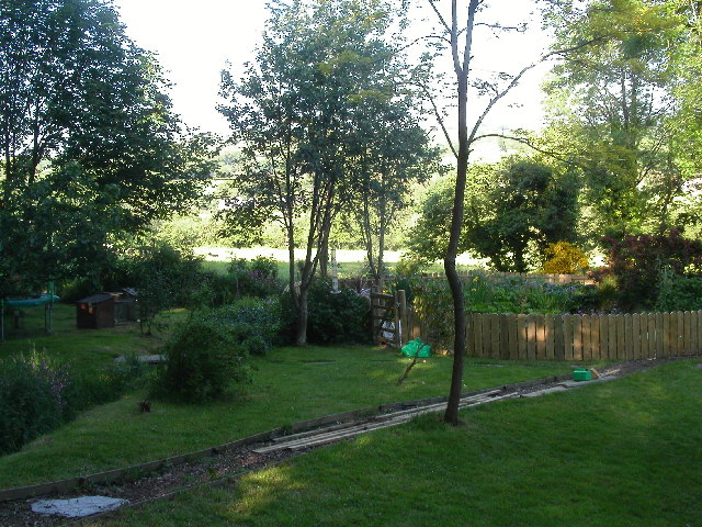
Allt Dderw, located in Cardiganshire, Wales, is a picturesque wood or forest that covers a significant area. It is well-known for its natural beauty and diverse range of flora and fauna. The wood is situated in a hilly region, offering breathtaking views of the surrounding landscape.

Allt Dderw is home to a variety of tree species, including oak, beech, and ash. These trees provide a dense canopy that creates a cool and shaded environment, making it an ideal habitat for many animals and birds. The forest floor is covered with a rich carpet of ferns, mosses, and wildflowers, adding to its enchanting charm.

The wood is crisscrossed by numerous walking trails, allowing visitors to explore its splendor and immerse themselves in nature. The trails lead to hidden glades and small streams, enhancing the sense of tranquility and serenity that characterizes Allt Dderw. It is a popular spot for hiking, birdwatching, and nature photography.

The forest is also home to a diverse range of wildlife. Visitors might spot red squirrels darting between the branches, while badgers and foxes make their homes in the undergrowth. Bird enthusiasts can observe various species, including woodpeckers, nuthatches, and owls.

Allt Dderw is managed by a local conservation organization, ensuring the preservation of its natural beauty and protection of its inhabitants. The wood provides an important habitat for many species, contributing to the overall biodiversity of the region.

In conclusion, Allt Dderw is a remarkable wood in Cardiganshire, offering visitors a chance to immerse themselves in nature and experience the beauty of a diverse and thriving ecosystem.

If you have any feedback on the listing, please let us know in the comments section below.

Allt Dderw Images

Images are sourced within 2km of 52.133893/-4.3976993 or Grid Reference SN3551. Thanks to Geograph Open Source API. All images are credited.

Bridleway sign Bridleway sign beside a country road south of Plwmp.  The Plwmp transmitter can be seen in the distance.
Bridleway sign
Bridleway sign beside a country road south of Plwmp. The Plwmp transmitter can be seen in the distance.
Haymaking field Haymaking field beside a country road south of Plwmp.
Haymaking field
Haymaking field beside a country road south of Plwmp.
Foxgloves on the verge A fence with foxgloves in flower beside a road south of Plwmp.
Foxgloves on the verge
A fence with foxgloves in flower beside a road south of Plwmp.
Farmland near Blaenbedw Fach Farmland near Blaenbedw Fach south of Plwmp.
Farmland near Blaenbedw Fach
Farmland near Blaenbedw Fach south of Plwmp.
Field near Blaenbedw Fach Field near Blaenbedw Fach south of Plwmp.
Field near Blaenbedw Fach
Field near Blaenbedw Fach south of Plwmp.
Shop and Post Office Shop and Post Office in Plwmp.
Shop and Post Office
Shop and Post Office in Plwmp.
View to the coast from Plwmp
Ordnance Survey Cut Mark This OS cut mark can be found on Bwlch Rhyd. It marks a point 196.108m above mean sea level.
Ordnance Survey Cut Mark
This OS cut mark can be found on Bwlch Rhyd. It marks a point 196.108m above mean sea level.
Ordnance Survey Cut Mark This OS cut mark can be found on the NW parapet of the bridge. It marks a point 186.734m above mean sea level.
Ordnance Survey Cut Mark
This OS cut mark can be found on the NW parapet of the bridge. It marks a point 186.734m above mean sea level.
Ordnance Survey Cut Mark This OS cut mark can be found on Rhyd Fach. It marks a point 210.601m above mean sea level.
Ordnance Survey Cut Mark
This OS cut mark can be found on Rhyd Fach. It marks a point 210.601m above mean sea level.
Ordnance Survey Cut Mark This OS cut mark can be found on the roadside barn at Ty-rhos Farm. It marks a point 230.302m above mean sea level.
Ordnance Survey Cut Mark
This OS cut mark can be found on the roadside barn at Ty-rhos Farm. It marks a point 230.302m above mean sea level.
Ordnance Survey Cut Mark This OS cut mark can be found on the SW parapet of Blaen Bedw Fawr Bridge. It marks a point 195.213m above mean sea level.
Ordnance Survey Cut Mark
This OS cut mark can be found on the SW parapet of Blaen Bedw Fawr Bridge. It marks a point 195.213m above mean sea level.
Ordnance Survey Cut Mark This OS cut mark can be found on the roadside barn at Blaenbedw Fawr Farm. It marks a point 199.244m above mean sea level.
Ordnance Survey Cut Mark
This OS cut mark can be found on the roadside barn at Blaenbedw Fawr Farm. It marks a point 199.244m above mean sea level.
Churn Stand There is an Ordnance Survey rivet on the top of the stand. <a title="https://www.geograph.org.uk/photo/7446195" href="https://www.geograph.org.uk/photo/7446195">Link</a>
Churn Stand
There is an Ordnance Survey rivet on the top of the stand. Link
Ordnance Survey Rivet This OS rivet can be found on the top of the churn stand. It marks a point 242.873m above mean sea level. <a title="https://www.geograph.org.uk/photo/7446194" href="https://www.geograph.org.uk/photo/7446194">Link</a>
Ordnance Survey Rivet
This OS rivet can be found on the top of the churn stand. It marks a point 242.873m above mean sea level. Link
Ordnance Survey Cut Mark This OS cut mark can be found on the wall at the entrance to Cwm Bedw. It marks a point 186.093m above mean sea level.
Ordnance Survey Cut Mark
This OS cut mark can be found on the wall at the entrance to Cwm Bedw. It marks a point 186.093m above mean sea level.
A487 nearing Pentregat
A487 at Plwmp village boundary
Show me another place!

Allt Dderw is located at Grid Ref: SN3551 (Lat: 52.133893, Lng: -4.3976993)

Unitary Authority: Ceredigion

Police Authority: Dyfed Powys

What 3 Words

///grove.clocked.appraised. Near Llanllwchaiarn, Ceredigion

Related Wikis

Pentre-gat

Pentre-gat is a small village in the community of Llangrannog, Ceredigion, Wales, which is 69.6 miles (112 km) from Swansea and 381 miles (302.3 km) from...

Blaenbedw Fawr

Blaenbedw Fawr is a small village in the community of Llandysiliogogo, Ceredigion, Wales, which is 68.9 miles (110.8 km) from Cardiff and 187 miles (300...

Brynhoffnant

Brynhoffnant is a small village in the community of Penbryn, Ceredigion, Wales, which is 70.4 miles (113.3 km) from Cardiff and 189.1 miles (304.3 km)...

Cwmcoednerth

Cwmcoednerth is a hamlet in the community of Penbryn, Ceredigion, Wales, which is 68.6 miles (110.4 km) from Cardiff and 188 miles (302.5 km) from London...

A486 road

The A486 is an A road in Wales linking New Quay, Ceredigion, with the A484 in Saron (Llangeler), Carmarthenshire. == Route == The road begins in New Quay...

Blaen Celyn

Blaen Celyn is a hamlet in the community of Llangrannog, Ceredigion, Wales, 2 miles (3.2 km) east of Llangrannog village. The local St. David's Church...

Glasgoed, Ceredigion

Glasgoed is a small village in the community of Penbryn, Ceredigion, Wales, which is 69.5 miles (111.8 km) from Cardiff and 188.8 miles (303.8 km) from...

Penbontrhydyfoethau

Penbontrhydyfothau is a hamlet in the community of Llandysiliogogo, Ceredigion, Wales, which is 70.5 miles (113.4 km) from Cardiff and 187.9 miles (302...

Nearby Amenities

Located within 500m of 52.133893,-4.3976993
Direction: 195
Generator Method: photovoltaic
Generator Output Electricity: yes
Generator Solar Modules: 12
Generator Source: solar
Generator Type: solar_photovoltaic_panel
Location: roof
Power: generator
Lat/Long: 52.1341993/-4.3904462
Direction: 215
Generator Method: photovoltaic
Generator Output Electricity: yes
Generator Solar Modules: 4
Generator Source: solar
Generator Type: solar_photovoltaic_panel
Location: roof
Power: generator
Lat/Long: 52.1357847/-4.3963545
The data included in this document is from www.openstreetmap.org. The data is made available under ODbL.

Have you been to Allt Dderw?

Leave your review of Allt Dderw below (or comments, questions and feedback).