Burgh St Peter

Settlement in Norfolk South Norfolk

England

Burgh St Peter

Castle Drainage Mill
Castle Drainage Mill Credit: Matthew Chadwick

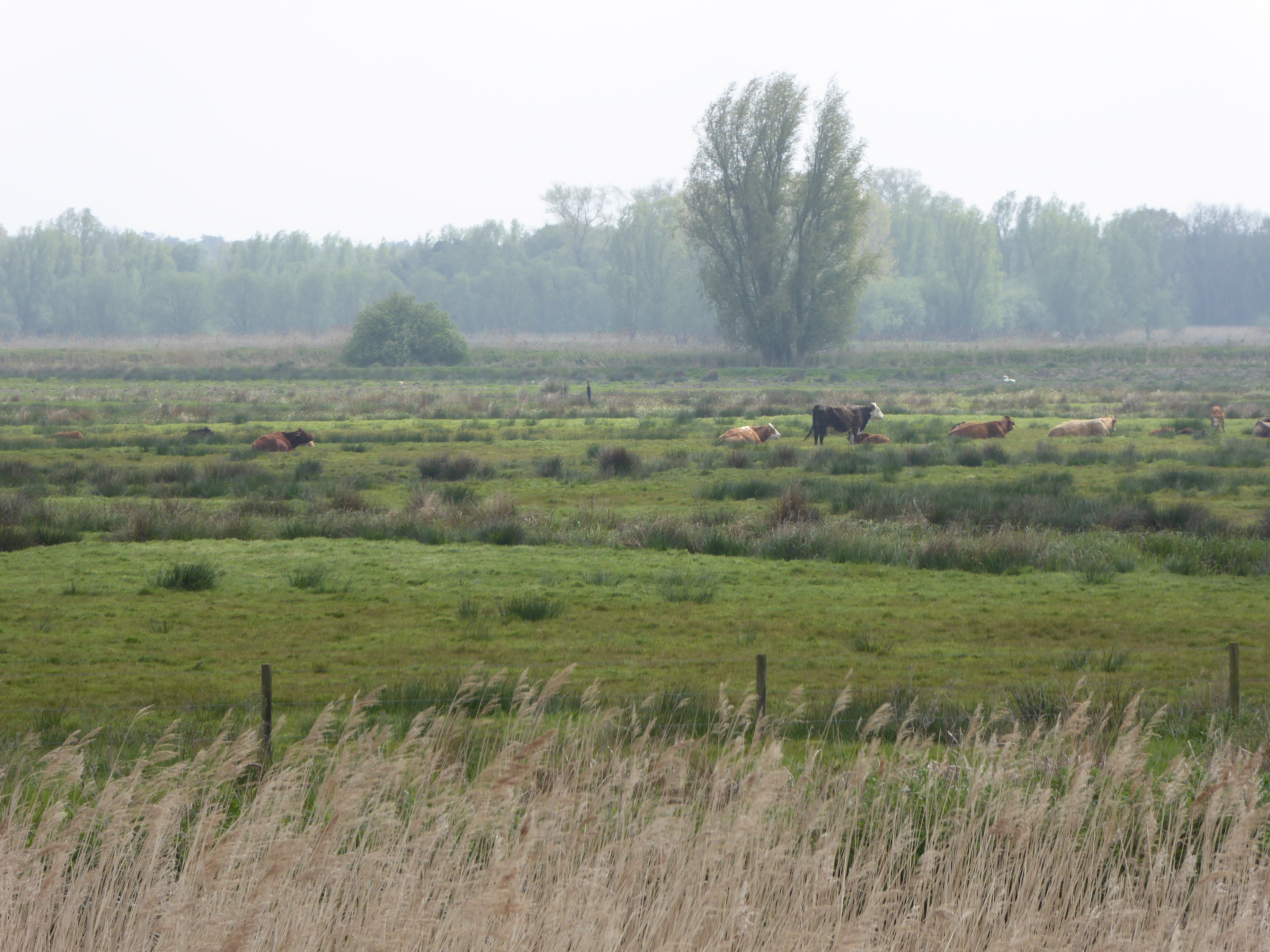
Burgh St Peter is a quaint village located in the county of Norfolk, England. Situated on the southeastern edge of the Norfolk Broads, it is surrounded by beautiful countryside and offers a peaceful and idyllic setting. The village is part of the South Norfolk district and is situated about 14 miles south of the city of Norwich.

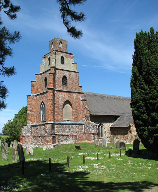
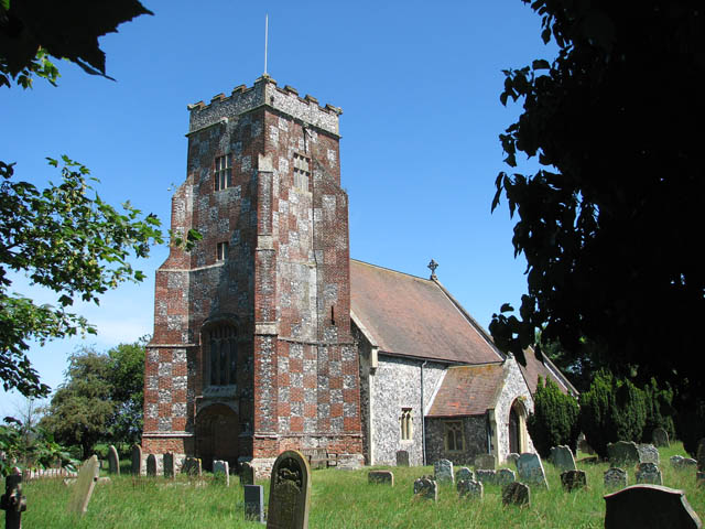
One of the prominent features of Burgh St Peter is its ancient parish church, St Peter's Church, which dates back to the 14th century. The church is known for its impressive architecture and holds historical significance within the village.

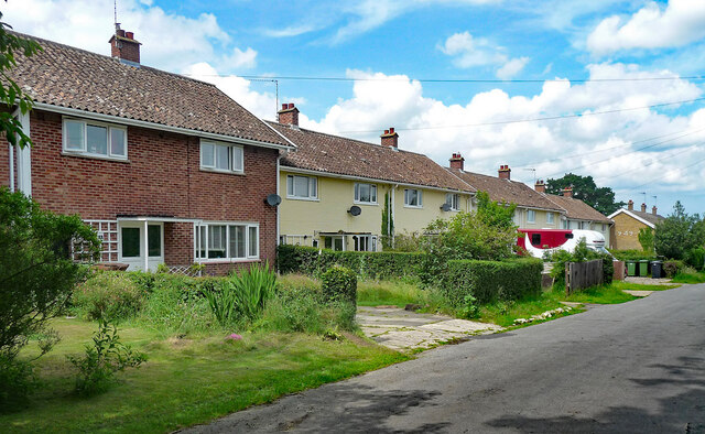
The village itself is relatively small, with a population of around 300 residents. It consists of a mix of traditional cottages and modern houses, creating a charming and picturesque atmosphere. The community is close-knit and friendly, with a strong sense of community spirit.

Burgh St Peter offers a range of amenities for its residents, including a village hall, a primary school, and a local pub. The surrounding countryside provides ample opportunities for outdoor activities, such as walking, cycling, and birdwatching. The nearby River Waveney also offers opportunities for boating and fishing.

Despite its tranquil and rural setting, Burgh St Peter is conveniently located near major road networks, making it easily accessible to nearby towns and cities. The village is a popular choice for those seeking a peaceful countryside lifestyle while still having access to urban amenities.

Overall, Burgh St Peter is a charming village with a rich history and a strong sense of community. Its picturesque setting and proximity to the Norfolk Broads make it an ideal destination for nature lovers and those seeking a peaceful retreat.

If you have any feedback on the listing, please let us know in the comments section below.

Burgh St Peter Images

Images are sourced within 2km of 52.484176/1.6314029 or Grid Reference TM4693. Thanks to Geograph Open Source API. All images are credited.

Castle Drainage Mill
Whiteways, Wheatacre One of several distinctive and thoughtful council housing projects by Herbert Tayler & David Green for Loddon District Council. Built in two phases, 1948 and 1957. Mostly two-storey houses.
Whiteways, Wheatacre
One of several distinctive and thoughtful council housing projects by Herbert Tayler & David Green for Loddon District Council. Built in two phases, 1948 and 1957. Mostly two-storey houses.
Angles Way A 77 mile long path. From Great Yarmouth the route goes by Breydon Water, along and near the River Waveney, passing around Oulton Broad, Beccles and Bungay, and Harleston and Diss, to its source, and then by the Little Ouse from its source very close by through heathland and marsh to Knettishall Heath in the Suffolk Brecks. Less than a mile onwards west across the heath the coincident start of the Peddars Way and finish of the Icknield Way Path are reached.
Logo <a href="https://www.geograph.org.uk/photo/7632664">TM3890 : Angles Way Logo</a>
Angles Way
A 77 mile long path. From Great Yarmouth the route goes by Breydon Water, along and near the River Waveney, passing around Oulton Broad, Beccles and Bungay, and Harleston and Diss, to its source, and then by the Little Ouse from its source very close by through heathland and marsh to Knettishall Heath in the Suffolk Brecks. Less than a mile onwards west across the heath the coincident start of the Peddars Way and finish of the Icknield Way Path are reached. Logo TM3890 : Angles Way Logo
Reed beds
Reed beds
Castle Marsh
Castle Marsh
Angles Way A 77 mile long path. From Great Yarmouth the route goes by Breydon Water, along and near the River Waveney, passing around Oulton Broad, Beccles and Bungay, and Harleston and Diss, to its source, and then by the Little Ouse from its source very close by through heathland and marsh to Knettishall Heath in the Suffolk Brecks. Less than a mile onwards west across the heath the coincident start of the Peddars Way and finish of the Icknield Way Path are reached.
Logo <a href="https://www.geograph.org.uk/photo/7632664">TM3890 : Angles Way Logo</a>
Angles Way
A 77 mile long path. From Great Yarmouth the route goes by Breydon Water, along and near the River Waveney, passing around Oulton Broad, Beccles and Bungay, and Harleston and Diss, to its source, and then by the Little Ouse from its source very close by through heathland and marsh to Knettishall Heath in the Suffolk Brecks. Less than a mile onwards west across the heath the coincident start of the Peddars Way and finish of the Icknield Way Path are reached. Logo TM3890 : Angles Way Logo
Drainage ditch
Drainage ditch
Reeds, Castle Marsh
Reeds, Castle Marsh
River Waveney The River Waveney forms the boundary between Suffolk and Norfolk. It rises at Redgrave Fen and flows in an easterly direction though the towns of Diss, Bungay (the head of navigation) and Beccles. There is a weir at Billingford, shortly after the River Dove, flowing northwards from Eye, joins the Waveney on the southern bank. The Waveney passes round Bungay and on to Beccles. Having skirted past Oulton Broad it passes through Somerleyton and Hadiscoe before merging with the Yare in Breydon Water.
River Waveney
The River Waveney forms the boundary between Suffolk and Norfolk. It rises at Redgrave Fen and flows in an easterly direction though the towns of Diss, Bungay (the head of navigation) and Beccles. There is a weir at Billingford, shortly after the River Dove, flowing northwards from Eye, joins the Waveney on the southern bank. The Waveney passes round Bungay and on to Beccles. Having skirted past Oulton Broad it passes through Somerleyton and Hadiscoe before merging with the Yare in Breydon Water.
Castle Drainage Mill
Former crossing keeper's cottage, Waterheath Road The crossing was once on the Beccles to Great Yarmouth railway line which eventually closed in 1964/5 after the sugarbeet season having been in service 110 years since November 1854.
Having branched off the Beccles-Lowestoft line it crossed the River Waveney at the swing bridge <a title="https://www.geograph.org.uk/photo/2603169" href="https://www.geograph.org.uk/photo/2603169">Link</a> and on to Aldeby Station before continuing to Great Yarmouth via Belton.
Former crossing keeper's cottage, Waterheath Road
The crossing was once on the Beccles to Great Yarmouth railway line which eventually closed in 1964/5 after the sugarbeet season having been in service 110 years since November 1854. Having branched off the Beccles-Lowestoft line it crossed the River Waveney at the swing bridge Link and on to Aldeby Station before continuing to Great Yarmouth via Belton.
Aldeby pastures A horse and cows (in the background) on the low grassland near Aldeby
Aldeby pastures
A horse and cows (in the background) on the low grassland near Aldeby
Priory Farmhouse Note the four staged brick buttresses at the south of the building.

Listed building ID: 226782 <span class="nowrap"><a title="https://historicengland.org.uk/listing/the-list/list-entry/1050601" rel="nofollow ugc noopener" href="https://historicengland.org.uk/listing/the-list/list-entry/1050601">Link</a><img style="margin-left:2px;" alt="External link" title="External link - shift click to open in new window" src="https://s1.geograph.org.uk/img/external.png" width="10" height="10"/></span> 

Late C17/early C18 and later: dated SL-1719 on tie irons of north gable. Brick and flint
Priory Farmhouse
Note the four staged brick buttresses at the south of the building. Listed building ID: 226782 LinkExternal link Late C17/early C18 and later: dated SL-1719 on tie irons of north gable. Brick and flint
Toft Monks Crossing Cottage Seen at the junction of Crabtree Lane and Waterheath Road.

This was once a level crossing cottage on the Beccles to Yarmouth section of the East Suffolk line, which closed in 1959.

The cottage has been extended since the closure of the line which would have run just to the west Crabtree Lane.
Toft Monks Crossing Cottage
Seen at the junction of Crabtree Lane and Waterheath Road. This was once a level crossing cottage on the Beccles to Yarmouth section of the East Suffolk line, which closed in 1959. The cottage has been extended since the closure of the line which would have run just to the west Crabtree Lane.
Barn at Priory Farm Traditional pattern red brick barn at Priory Farm.
Barn at Priory Farm
Traditional pattern red brick barn at Priory Farm.
Gate and driveway to All Saints' Church, Wheatacre
Show me another place!

Burgh St Peter is located at Grid Ref: TM4693 (Lat: 52.484176, Lng: 1.6314029)

Administrative County: Norfolk

District: South Norfolk

Police Authority: Norfolk

What 3 Words

///chucked.community.decades. Near Beccles, Suffolk

Nearby Locations

Wheatacre Burgh St Peter

Related Wikis

Burgh St Peter

Burgh St Peter is a village and civil parish in the South Norfolk district of Norfolk, England. The village is about 3+1⁄2 miles (6 km) northeast of Beccles...

Wheatacre

Wheatacre is a civil parish in the English county of Norfolk. It covers an area of 4.38 km2 (1.69 sq mi) and had a population of 112 in 43 households at...

Aldeby

Aldeby is a village and civil parish in the English county of Norfolk. It is bounded to the south by the River Waveney, on the other side of which is Suffolk...

Barnby Broad and Marshes

Barnby Broad and Marshes is a Site of Special Scientific Interest (SSSI) in the Waveney district of the English county of Suffolk. The site is 189.6 hectares...

Nearby Amenities

Located within 500m of 52.484176,1.6314029
Pub
White Lion
Addr Postcode: NR34 0AT
Addr Street: White Lion Road
Addr Village: Wheatacre
Fhrs Id: 1005753
Source Addr: FHRS Open Data
Lat/Long: 52.4851843/1.6264982
Bus Stop
Mill Road, opp
Bus: yes
Naptan AtcoCode: 2900B601
Naptan Bearing: E
Naptan CommonName: Mill Road
Naptan Indicator: opp
Naptan Locality: Burgh St Peter
Naptan NaptanCode: nfoagpdp
Naptan Street: Beccles Road
Naptan Verified: no
Public Transport: platform
Source: naptan_import
Lat/Long: 52.4842239/1.6296684
Bus Stop
Mill Road, adj
Bus: yes
Naptan AtcoCode: 2900B602
Naptan Bearing: W
Naptan CommonName: Mill Road
Naptan Indicator: adj
Naptan Locality: Burgh St Peter
Naptan NaptanCode: nfoagpdt
Naptan Street: Beccles Road
Naptan Verified: no
Public Transport: platform
Source: naptan_import
Lat/Long: 52.4840707/1.6308492
White Lion Road, adj
Naptan AtcoCode: 2900W231
Naptan Bearing: SE
Naptan BusStopType: CUS
Naptan CommonName: White Lion Road
Naptan Indicator: adj
Naptan Landmark: White Lion Public House
Naptan Locality: Wheatacre
Naptan NaptanCode: nfogdmjd
Naptan ShortCommonName: White Lion Road
Naptan Street: White Lion Road
Naptan Verified: no
Source: naptan_import
Lat/Long: 52.4851154/1.6264121
White Lion Road, opp
Naptan AtcoCode: 2900W232
Naptan Bearing: NW
Naptan BusStopType: CUS
Naptan CommonName: White Lion Road
Naptan Indicator: opp
Naptan Landmark: White Lion Public House
Naptan Locality: Wheatacre
Naptan NaptanCode: nfogdmjg
Naptan ShortCommonName: White Lion Road
Naptan Street: White Lion Road
Naptan Verified: no
Source: naptan_import
Lat/Long: 52.4850396/1.6262438
Burgh St Peter
Alt Name: Burgh Saint Peter
Place: village
Wikidata: Q616577
Wikipedia: en:Burgh St Peter
Lat/Long: 52.4844522/1.6322194
Common Road, SW-Bound
Naptan AtcoCode: 2900B603
Naptan Bearing: SW
Naptan BusStopType: CUS
Naptan CommonName: Common Road
Naptan Indicator: SW-Bound
Naptan Locality: Burgh St Peter
Naptan NaptanCode: nfogtgpw
Naptan Street: Common Road
Naptan Verified: no
Source: naptan_import
Lat/Long: 52.4825248/1.6255358
Wheatacre
Place: hamlet
Wikidata: Q2099189
Wikipedia: en:Wheatacre
Lat/Long: 52.4871575/1.627544
Give Way
Direction: forward
Lat/Long: 52.4843099/1.6270937
Give Way
Lat/Long: 52.4856212/1.6256683
Give Way
Lat/Long: 52.4856992/1.6255736
Give Way
Direction: forward
Lat/Long: 52.4842904/1.6259799
Power: pole
Lat/Long: 52.4839302/1.6256306
Power: pole
Lat/Long: 52.4841572/1.6279024
Location Transition: yes
Power: pole
Lat/Long: 52.4843369/1.629847
Wheatacre Burgh St. Peter
Alt Name: Burgh St Peter
Man Made: village_sign
Material: fibreglass
Short Name: Wheatacre
Lat/Long: 52.484256/1.6289297
Give Way
Direction: forward
Lat/Long: 52.4842496/1.6314431
Give Way
Direction: forward
Lat/Long: 52.4841768/1.6314442
Defibrillator
Defibrillator Location: Clearly visible from service road to car park, on the side of the Village Hall
Emergency: defibrillator
Indoor: no
Ref GB The Circuit: 39908FA2-C1E8-4CE3-98BC-AED400BFD75D
Lat/Long: 52.4834036/1.6356756
Post Box
Brand: Royal Mail
Brand Wikidata: Q638098
Brand Wikipedia: en:Royal Mail
Drive Through: no
Operator: Royal Mail
Operator Wikidata: Q638098
Lat/Long: 52.4841204/1.629741
Information: board
Lit: no
Support: pole
Tourism: information
Lat/Long: 52.4841229/1.6296995
The data included in this document is from www.openstreetmap.org. The data is made available under ODbL.

Have you been to Burgh St Peter?

Leave your review of Burgh St Peter below (or comments, questions and feedback).