Allt Blaenffynhonnau

Wood, Forest in Carmarthenshire

Wales

Allt Blaenffynhonnau

Footpath obstruction near Llangynin Hedges and barbed wire fences across footpaths are common (almost standard) in this part of Carmarthenshire
Footpath obstruction near Llangynin Credit: Alistair Hare

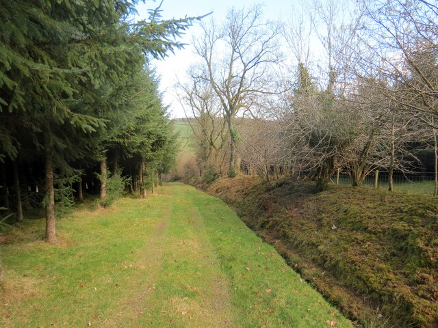
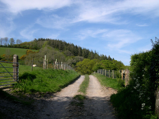
Allt Blaenffynhonnau is a stunning woodland located in Carmarthenshire, Wales. Covering an area of approximately 100 hectares, it is a natural haven of lush greenery and diverse wildlife. The woodland is situated on a steep hillside, providing visitors with breathtaking views of the surrounding countryside.

The woodland is predominantly composed of native tree species such as oak, ash, and birch, creating a rich and varied ecosystem. These trees provide shelter and food for a wide range of animal species, including birds, mammals, and insects. In spring, the woodland comes alive with a vibrant display of wildflowers, adding bursts of color to the landscape.

Allt Blaenffynhonnau is a popular destination for nature enthusiasts and hikers. It offers a network of well-maintained trails, allowing visitors to explore the woodland at their own pace. The paths meander through the trees, leading to hidden glades and tranquil streams. There are also picnic areas where visitors can relax and enjoy the peaceful surroundings.

The woodland is managed by a local conservation organization, ensuring its preservation and protection for future generations. They actively work to maintain the biodiversity of the area and promote sustainable practices.

Allt Blaenffynhonnau is not only a place of natural beauty but also holds cultural significance. It has historical ties to the local community and has been a source of inspiration for artists and writers throughout the years.

In summary, Allt Blaenffynhonnau is a captivating woodland in Carmarthenshire, offering a sanctuary of tranquility and natural wonders. With its diverse wildlife, picturesque trails, and cultural heritage, it is a must-visit destination for anyone seeking to connect with nature.

If you have any feedback on the listing, please let us know in the comments section below.

Allt Blaenffynhonnau Images

Images are sourced within 2km of 51.846088/-4.5321941 or Grid Reference SN2519. Thanks to Geograph Open Source API. All images are credited.

Footpath obstruction near Llangynin Hedges and barbed wire fences across footpaths are common (almost standard) in this part of Carmarthenshire
Footpath obstruction near Llangynin
Hedges and barbed wire fences across footpaths are common (almost standard) in this part of Carmarthenshire
Gweddillion Eithin / The remains of Eithin Gweddillion anhedd-dy o'r enw Eithin.

The remains of a property known as Eithin (trans. Gorse).
Gweddillion Eithin / The remains of Eithin
Gweddillion anhedd-dy o'r enw Eithin. The remains of a property known as Eithin (trans. Gorse).
Llwybr Eithin / Eithin Path Llwybr cyhoeddus yn mynd i gyfeiriad planhigfa gonifferaidd Eithin.

A public footpath heading towards Eithin (trans. gorse) conifer plantation.
Llwybr Eithin / Eithin Path
Llwybr cyhoeddus yn mynd i gyfeiriad planhigfa gonifferaidd Eithin. A public footpath heading towards Eithin (trans. gorse) conifer plantation.
Llwybr Eithin / Eithin Path Llwybr cyhoeddus yn mynd i lawr y waered ym mhlanhigfa gonifferaidd Eithin.

A public footpath descends within Eithin (trans. gorse) conifer plantation,
Llwybr Eithin / Eithin Path
Llwybr cyhoeddus yn mynd i lawr y waered ym mhlanhigfa gonifferaidd Eithin. A public footpath descends within Eithin (trans. gorse) conifer plantation,
Llwybr Cethin / Cethin Path Llwybr troed cyhoeddus yn mynd i gyfeiriad Ffarm Cethin.

A public footpath heads in the direction of Cethin Farm.
Llwybr Cethin / Cethin Path
Llwybr troed cyhoeddus yn mynd i gyfeiriad Ffarm Cethin. A public footpath heads in the direction of Cethin Farm.
Llwybr Cethin / Cethin Path Llwybr cyhoeddus yn gadael heol fynedfa.

A public footpath exits an access road.
Llwybr Cethin / Cethin Path
Llwybr cyhoeddus yn gadael heol fynedfa. A public footpath exits an access road.
Llwybr i Rhydyceisiad / Path to Rhydyceisiad Llwybr troed cyhoeddus yn mynd i anhedd-dy o'r enw Rhydyceisiad.

A public footpath heading towards a property known as Rhydyceisiad.
Llwybr i Rhydyceisiad / Path to Rhydyceisiad
Llwybr troed cyhoeddus yn mynd i anhedd-dy o'r enw Rhydyceisiad. A public footpath heading towards a property known as Rhydyceisiad.
Llwybr yn agosau at yr heol / Path approaching the road Llwybr cyhoeddus a heol fynedfa yn cyrraedd y brif ffordd.

A public footpath and access road approaches the main road.
Llwybr yn agosau at yr heol / Path approaching the road
Llwybr cyhoeddus a heol fynedfa yn cyrraedd y brif ffordd. A public footpath and access road approaches the main road.
Llwybr yn gadael yr heol / Path exits the road Llwybr troed cyhoeddus yn gadael yr heol wrth ymyl Eithinduon. 

A public footpath exits the road at Eithinduon (trans. black gorse).
Llwybr yn gadael yr heol / Path exits the road
Llwybr troed cyhoeddus yn gadael yr heol wrth ymyl Eithinduon. A public footpath exits the road at Eithinduon (trans. black gorse).
Track to Castell Gorford
Woodland below Ffynonlwyd Farm
Farmhouse and cottage at Ffynnonlwyd
Groveland Go Kart track at Groveland Adventure Park not far off the A40 near St.Clears
Groveland
Go Kart track at Groveland Adventure Park not far off the A40 near St.Clears
Groveland Adventure World seen from Llangynin Church
Groveland Adventure World
seen from Llangynin Church
DIY level crossing Traffic lights are provided to warn you of trains.
DIY level crossing
Traffic lights are provided to warn you of trains.
St. Cynin Church Although more than a mile from Llangynin, this is its parish church. <a href="https://www.geograph.org.uk/photo/472577">SN2618 : Llwynbychan Farm</a> can be seen in the distance. The river nearby is called Afon Cynin and the name Llangynin is derived from St Cynin.
St. Cynin Church
Although more than a mile from Llangynin, this is its parish church. SN2618 : Llwynbychan Farm can be seen in the distance. The river nearby is called Afon Cynin and the name Llangynin is derived from St Cynin.
Llwynbychan Farm <a href="https://www.geograph.org.uk/photo/472574">SN2518 : St. Cynin Church</a> can be seen in the distance.
Llwynbychan Farm
SN2518 : St. Cynin Church can be seen in the distance.
Bryn Chapel Baptist Chapel built in 1868
Bryn Chapel
Baptist Chapel built in 1868
Show me another place!

Allt Blaenffynhonnau is located at Grid Ref: SN2519 (Lat: 51.846088, Lng: -4.5321941)

Unitary Authority: Carmarthenshire

Police Authority: Dyfed Powys

What 3 Words

///starts.unwell.blogging. Near St Clears, Carmarthenshire

Related Wikis

Llangynin

Llangynin is a village and community located in Carmarthenshire, Wales. The Welsh language name of the village means "the church of St. Cynin" The population...

Great Western Railway in West Wales

The Great Western Railway was a railway company that was dominant in West Wales, in the United Kingdom. The main line from Swansea to Neyland, a port on...

St Clears railway station

St Clears railway station served the town of St Clears, Carmarthenshire, Wales between 1854 and 1964. It was on the West Wales Line. == History == The...

St Clears

St Clears ( KLAIRZ; Welsh: Sanclêr) is a town on the River Taf and a community in Carmarthenshire, Wales. At the 2011 census, the population was 2,995...

Nearby Amenities

Located within 500m of 51.846088,-4.5321941
Power: pole
Lat/Long: 51.8426187/-4.5285773
Power: pole
Lat/Long: 51.8424861/-4.5301867
Power: pole
Lat/Long: 51.842274/-4.5317853
Power: pole
Lat/Long: 51.8420718/-4.5335019
Give Way
Direction: backward
Lat/Long: 51.8418669/-4.5332998
Direction: SE
Generator Method: photovoltaic
Generator Output Electricity: yes
Generator Solar Modules: 16
Generator Source: solar
Generator Type: solar_photovoltaic_panel
Location: roof
Power: generator
Lat/Long: 51.8441132/-4.5362967
Direction: 235
Generator Method: photovoltaic
Generator Output Electricity: yes
Generator Solar Modules: 20
Generator Source: solar
Generator Type: solar_photovoltaic_panel
Location: roof
Power: generator
Lat/Long: 51.8442611/-4.5370705
The data included in this document is from www.openstreetmap.org. The data is made available under ODbL.

Have you been to Allt Blaenffynhonnau?

Leave your review of Allt Blaenffynhonnau below (or comments, questions and feedback).