Allt Pen-gegin-isaf

Wood, Forest in Pembrokeshire

Wales

Allt Pen-gegin-isaf

Ordnance Survey Cut Mark This OS cut mark can be found on a gatepost SW side of the road. It marks a point 196.666m above mean sea level.
Ordnance Survey Cut Mark Credit: Adrian Dust

Allt Pen-gegin-isaf is a scenic wood located in Pembrokeshire, Wales. Covering an area of approximately 50 hectares, this forested area is known for its natural beauty and diverse wildlife.

The wood is characterized by its lush greenery, comprising a mix of deciduous and coniferous trees. Visitors can explore the numerous walking trails that wind through the forest, offering breathtaking views of the surrounding landscape. The terrain is hilly, with some steep slopes, adding an element of adventure to the experience.

Flora and fauna thrive in Allt Pen-gegin-isaf, with a variety of plant species dotting the forest floor. Bluebells, foxgloves, and primroses are just a few of the colorful flowers that bloom here during springtime. The forest is also home to a range of wildlife, including deer, badgers, rabbits, and a wide array of bird species, making it a popular spot for birdwatching enthusiasts.

In addition to its natural beauty, Allt Pen-gegin-isaf holds historical significance. The wood is believed to have been part of an ancient Celtic settlement, with remnants of stone structures and earthworks still visible today.

Accessible to the public, the wood offers a peaceful retreat for nature lovers and outdoor enthusiasts alike. Whether it's a leisurely stroll or a more challenging hike, Allt Pen-gegin-isaf provides an opportunity to immerse oneself in the tranquility of nature while enjoying the stunning surroundings.

If you have any feedback on the listing, please let us know in the comments section below.

Allt Pen-gegin-isaf Images

Images are sourced within 2km of 51.970415/-4.8684553 or Grid Reference SN0334. Thanks to Geograph Open Source API. All images are credited.

Ordnance Survey Cut Mark This OS cut mark can be found on a gatepost SW side of the road. It marks a point 196.666m above mean sea level.
Ordnance Survey Cut Mark
This OS cut mark can be found on a gatepost SW side of the road. It marks a point 196.666m above mean sea level.
Ordnance Survey Rivet This OS rivet can be found on a stone NW side of the road. It marks a point 239.765m above mean sea level.
Ordnance Survey Rivet
This OS rivet can be found on a stone NW side of the road. It marks a point 239.765m above mean sea level.
B4313 at Erw-Lon Farm
B4313 at Pen Bank
B4313 at Pen Bank
B4313 near Gwaun Valley Brewery
Allt Pontfaen car park The National Park have created a car park here so that walkers and visitors to Cwm Gwaun don't clutter up the village with their cars.
Allt Pontfaen car park
The National Park have created a car park here so that walkers and visitors to Cwm Gwaun don't clutter up the village with their cars.
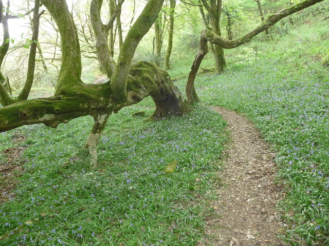
Footpath in woodland in the Gwaun valley on May Day Bluebells grow below the twisted moss covered trunk of this old tree, possibly once part of a laid hedge.
Footpath in woodland in the Gwaun valley on May Day
Bluebells grow below the twisted moss covered trunk of this old tree, possibly once part of a laid hedge.
Path through woodland in Cwm Gwaun The path here climbs steeply through woodland towards the fields above the valley side. The path seems more used by animals than human feet.
Path through woodland in Cwm Gwaun
The path here climbs steeply through woodland towards the fields above the valley side. The path seems more used by animals than human feet.
Track towards Penlanisaf Farm The lambs ahead have squeezed under a gate to get at lush grass alongside the track and have been caught out by my arrival on the scene. They ran ahead and eventually ran out of track and had to sprint back past me, leaping, kicking and bucking.
Track towards Penlanisaf Farm
The lambs ahead have squeezed under a gate to get at lush grass alongside the track and have been caught out by my arrival on the scene. They ran ahead and eventually ran out of track and had to sprint back past me, leaping, kicking and bucking.
Old railway wagons as sheds at Penlanisaf You don't see as many old railway wagons on farms as you used to. They were common when I was a lad but, like these two examples, are aging fast and being replaced by more purpose designed storage. The old implement is of even greater vintage.
Old railway wagons as sheds at Penlanisaf
You don't see as many old railway wagons on farms as you used to. They were common when I was a lad but, like these two examples, are aging fast and being replaced by more purpose designed storage. The old implement is of even greater vintage.
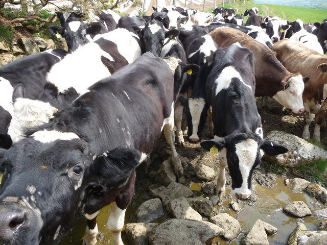
Young cattle show their interest These young cattle were very interested in me, their new two-legged friend, and pursued me down the field to the stile with avid curiosity tempered with very little nervousness.
Young cattle show their interest
These young cattle were very interested in me, their new two-legged friend, and pursued me down the field to the stile with avid curiosity tempered with very little nervousness.
The Dyffryn Arms Free House, Pontfaen, Cwm Gwaun Proprietor Bessie Davies so the pub, I believe, is often known as Tafarn Bessie and rightly so. A 'parlour inn' summarises the style of service, now a genuine rarity and the interior is a time capsule, with a sepia photograph of Edward VIII as a young Prince of Wales and a portrait of our present Queen as a newly crowned monarch. Bass in jugs, bi-lingual conversations and parking on the road outside. Don't expect gastro-pub lunches.
The Dyffryn Arms Free House, Pontfaen, Cwm Gwaun
Proprietor Bessie Davies so the pub, I believe, is often known as Tafarn Bessie and rightly so. A 'parlour inn' summarises the style of service, now a genuine rarity and the interior is a time capsule, with a sepia photograph of Edward VIII as a young Prince of Wales and a portrait of our present Queen as a newly crowned monarch. Bass in jugs, bi-lingual conversations and parking on the road outside. Don't expect gastro-pub lunches.
Pontfaen: the bridge which gives the place its name Seen from its upstream side, on a rainy evening.
Pontfaen: the bridge which gives the place its name
Seen from its upstream side, on a rainy evening.
Ffald-y-Brenin A Christian retreat centre with a superb setting above the Gwaun Valley.
Ffald-y-Brenin
A Christian retreat centre with a superb setting above the Gwaun Valley.
The remains of a house in Coed Tregynon This is at the junction of two paths, taking the higher or lower route along the valley side.
The remains of a house in Coed Tregynon
This is at the junction of two paths, taking the higher or lower route along the valley side.
Path across the Gwaun Valley There aren't many routes across the valley, but this is one.
Path across the Gwaun Valley
There aren't many routes across the valley, but this is one.
Afon Gwaun The river meanders down the flat valley bottom, but it isn't often seen.
Afon Gwaun
The river meanders down the flat valley bottom, but it isn't often seen.
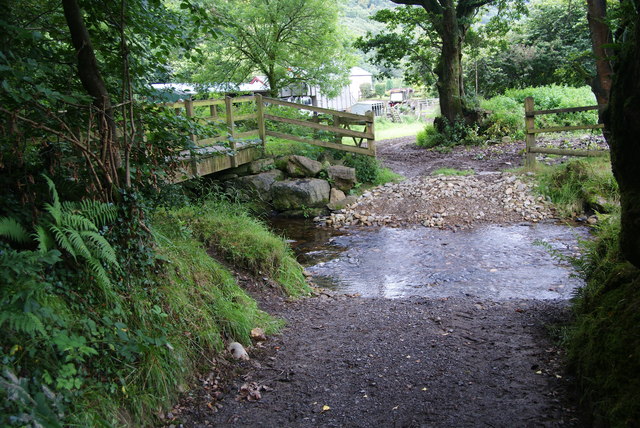
Ford at Dan Coed This crosses a stream which very shortly runs into Afon Gwaun.
Ford at Dan Coed
This crosses a stream which very shortly runs into Afon Gwaun.
Show me another place!

Allt Pen-gegin-isaf is located at Grid Ref: SN0334 (Lat: 51.970415, Lng: -4.8684553)

Unitary Authority: Pembrokeshire

Police Authority: Dyfed Powys

What 3 Words

///official.dressings.ropes. Near Newport, Pembrokeshire

Related Wikis

Cwm Gwaun

Cwm Gwaun (English: Gwaun Valley) is a community and valley in north Pembrokeshire, Wales. The community is centred around Pontfaen, a parish and hamlet...

Pontfaen

Pontfaen (English: Bridge on the River Gwaun) is a small rural village and parish in the community of Cwm Gwaun, north Pembrokeshire, Wales. It is 3 miles...

Allt Pontfaen - Coed Gelli-fawr

Allt Pontfaen - Coed Gelli-fawr is a Site of Special Scientific Interest (or SSSI) in Pembrokeshire, South Wales which starts at Allt Pontfaen and finishes...

Cwm Bach, Sychpant

Cwm Bach, Sychpant is a Site of Special Scientific Interest (or "SSSI") in Pembrokeshire, South Wales. It has been designated as a Site of Special Scientific...

Dyffryn Gwaun

Dyffryn Gwaun is a Site of Special Scientific Interest (SSSI) in Pembrokeshire, South Wales. It has been designated as a Site of Special Scientific Interest...

Morvil

Morvil or Morfil is a remote upland parish on the southern slopes of the Preseli Mountains in north Pembrokeshire, Wales. Fishguard is 6 miles (10 km)...

Gallt Llanerch - Coed Gelli-deg

Gallt Llanerch - Coed Gelli-deg is a Site of Special Scientific Interest (or SSSI) in the Gwaun Valley, Pembrokeshire, South Wales. It has been designated...

Puncheston railway station

Puncheston railway station served the village of Puncheston, Pembrokeshire, Wales, from 1895 to 1949 on the North Pembrokeshire and Fishguard Railway....

Nearby Amenities

Located within 500m of 51.970415,-4.8684553
Give Way
Direction: forward
Lat/Long: 51.9697671/-4.8750174
Direction: 175
Generator Method: photovoltaic
Generator Output Electricity: yes
Generator Solar Modules: 16
Generator Source: solar
Generator Type: solar_photovoltaic_panel
Location: roof
Power: generator
Lat/Long: 51.9698752/-4.8728576
The data included in this document is from www.openstreetmap.org. The data is made available under ODbL.

Have you been to Allt Pen-gegin-isaf?

Leave your review of Allt Pen-gegin-isaf below (or comments, questions and feedback).