Caroline Grove

Wood, Forest in Pembrokeshire

Wales

Caroline Grove

Stackpole Quay Stackpole Quay is on the boundary between the Old Red Sandstone cliffs and grey Carboniferous Limestone. The limestone layers have been tilted into a vertical position. Today the harbour is used by local boatmen
Stackpole Quay Credit: Garth Newton

Caroline Grove is a charming woodland area located in Pembrokeshire, Wales. This picturesque forest is known for its lush greenery, towering trees, and peaceful atmosphere. Visitors to Caroline Grove can enjoy leisurely walks along the well-marked trails, taking in the sights and sounds of nature.

The forest is home to a variety of wildlife, including birds, squirrels, and deer, making it a popular spot for nature enthusiasts and birdwatchers. The diverse ecosystem within Caroline Grove provides a habitat for a wide range of plant and animal species, adding to the richness and beauty of the area.

The woodland is also a popular destination for outdoor activities such as hiking, picnicking, and photography. The tranquil setting of Caroline Grove provides a perfect escape from the hustle and bustle of everyday life, allowing visitors to relax and unwind in the midst of nature.

Overall, Caroline Grove is a serene and idyllic forest in Pembrokeshire, offering a peaceful retreat for those looking to connect with nature and enjoy the beauty of the outdoors.

If you have any feedback on the listing, please let us know in the comments section below.

Caroline Grove Images

Images are sourced within 2km of 51.629414/-4.92084 or Grid Reference SR9796. Thanks to Geograph Open Source API. All images are credited.

Stackpole Quay Stackpole Quay is on the boundary between the Old Red Sandstone cliffs and grey Carboniferous Limestone. The limestone layers have been tilted into a vertical position. Today the harbour is used by local boatmen
Stackpole Quay
Stackpole Quay is on the boundary between the Old Red Sandstone cliffs and grey Carboniferous Limestone. The limestone layers have been tilted into a vertical position. Today the harbour is used by local boatmen
Barafundle Bay Barafundle Beach is a secluded place on the Stackpole Estate accessible by a footpath over the cliffs from Stackpole Quay.
Barafundle Bay
Barafundle Beach is a secluded place on the Stackpole Estate accessible by a footpath over the cliffs from Stackpole Quay.
Bosherton Lily Ponds In June this three mile stretch of water is covered with white lilies.
Bosherton Lily Ponds
In June this three mile stretch of water is covered with white lilies.
Bosherston Lakes The lakes, or lily ponds, are part of the National Trust's Stackpole Estate.
Bosherston Lakes
The lakes, or lily ponds, are part of the National Trust's Stackpole Estate.
The bridge at Stackpole Centre The eight arch bridge heading back through Stackpole Park
The bridge at Stackpole Centre
The eight arch bridge heading back through Stackpole Park
Near Stackpole Quay Grazing land adjacent to Pembrokeshire Coastal path.
Near Stackpole Quay
Grazing land adjacent to Pembrokeshire Coastal path.
View from near Stackpole. View north east from the Pembrokeshire Coastal path near Stackpole Quay looking north east towards Freshwater East.
View from near Stackpole.
View north east from the Pembrokeshire Coastal path near Stackpole Quay looking north east towards Freshwater East.
Gift wrapped. Cylindrical bales awaiting Winter.
Gift wrapped.
Cylindrical bales awaiting Winter.
Barafundle Bay Photo of Barafundle Bay from the east. This was taken at 10:00 am emphasising the effort it takes to get to this unspoilt beach.
Barafundle Bay
Photo of Barafundle Bay from the east. This was taken at 10:00 am emphasising the effort it takes to get to this unspoilt beach.
Bridge by Lily Ponds On the way to the "Water Lilies" GeoCache. A beautiful walk in the woods.
Bridge by Lily Ponds
On the way to the "Water Lilies" GeoCache. A beautiful walk in the woods.
Stackpole Inn An excellent pub, good food, good beer, friendly. Stopped here after a couple of nearby GeoCaches.
Stackpole Inn
An excellent pub, good food, good beer, friendly. Stopped here after a couple of nearby GeoCaches.
Lilies on the Bosherston Ponds. Dammed for Fishing Ponds.
Lilies on the Bosherston Ponds.
Dammed for Fishing Ponds.
The upper bridge at Bosherston Ponds.
Stackpole Quay and Cliffs. From the south. This is National Trust land.
Stackpole Quay and Cliffs.
From the south. This is National Trust land.
Barafundle Bay. Taken from the south. This is a secluded sandy bay, accessible only on foot. It is owned by the National Trust.
Barafundle Bay.
Taken from the south. This is a secluded sandy bay, accessible only on foot. It is owned by the National Trust.
Bridge 8 arch bridge on the Stackpole Estate.
Bridge
8 arch bridge on the Stackpole Estate.
Wall Clump A walled clump of trees named on the OS map as 'Wall Clump'.
Wall Clump
A walled clump of trees named on the OS map as 'Wall Clump'.
Eight arch bridge at Stackpole
Show me another place!

Caroline Grove is located at Grid Ref: SR9796 (Lat: 51.629414, Lng: -4.92084)

Unitary Authority: Pembrokeshire

Police Authority: Dyfed Powys

What 3 Words

///publisher.roosters.bill. Near Bosherston, Pembrokeshire

Related Wikis

Park House Outbuildings

Park House Outbuildings, Stackpole is a Site of Special Scientific Interest (or SSSI) in Pembrokeshire, South Wales, 4 kilometres (2.5 mi) south of Pembroke...
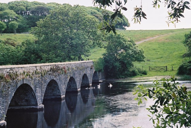
Eight-Arch Bridge

The Eight Arch Bridge on the Stackpole Estate is a grade II* listed construction, in Pembrokeshire, Wales. It is owned and maintained by the National...

Bosherston

Bosherston (Welsh: Llanfihangel-clogwyn-gofan, translates to "St Michaels above the cliffs of St Gofan") is a village and parish in Pembrokeshire, Wales...

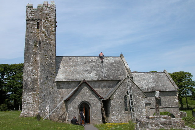
St Elidyr's Church, Stackpole

St Elidyr's Church (or St James & St Elidyr), is a Grade I listed building in south Pembrokeshire, Wales. The church is in the small village of Carew Cheriton...

Nearby Amenities

Located within 500m of 51.629414,-4.92084
Stackpole
Is In: Pembrokeshire,Wales,UK
Name Cy: Ystangbwll
Place: village
Lat/Long: 51.6304465/-4.9147282
Pub
Stackpole Inn
Addr Postcode: SA71 5DF
Fhrs Id: 857120
Source Addr Postcode: FHRS Open Data
Toilets Wheelchair: no
Wheelchair: limited
Wikidata: Q80582496
Lat/Long: 51.6308728/-4.9144449
Bus Stop
Lat/Long: 51.6294929/-4.9151745
Crossing
Lat/Long: 51.6310247/-4.9205083
Shelter
Shelter Type: public_transport
Lat/Long: 51.629799/-4.9149114
The data included in this document is from www.openstreetmap.org. The data is made available under ODbL.

Have you been to Caroline Grove?

Leave your review of Caroline Grove below (or comments, questions and feedback).