Yealand Redmayne

Civil Parish in Lancashire Lancaster

England

Yealand Redmayne

Storrs Farmhouse
Storrs Farmhouse Credit: Roger Cornfoot

Yealand Redmayne is a civil parish located in the district of Lancashire, England. Situated in the county's northern region, it is part of the City of Lancaster. The parish covers an area of approximately 2.5 square kilometers and has a population of around 300 residents.

Yealand Redmayne is a charming rural area characterized by its picturesque landscapes and tranquil atmosphere. It is mostly an agricultural community, with lush green fields and rolling hills surrounding the village. The parish is known for its beautiful countryside, making it a popular destination for nature enthusiasts and walkers.

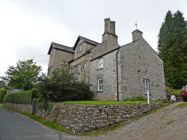
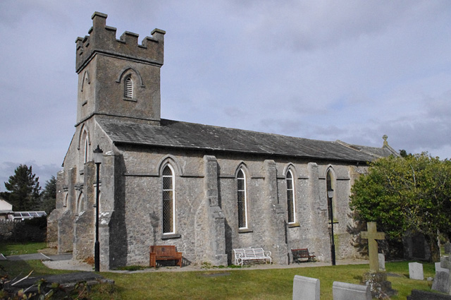
The village itself is small and quaint, with a tight-knit community. It consists of a handful of houses, farms, and a few local amenities. The centerpiece of the village is the St. Mary's Church, a historic building dating back to the 15th century. The church is a significant landmark and holds regular services for the local community.

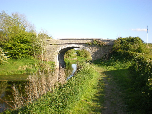
Despite its small size, Yealand Redmayne offers a range of recreational activities and attractions. The area is crisscrossed by footpaths and bridleways, providing opportunities for outdoor pursuits such as hiking and horseback riding. Nearby, visitors can explore the Leighton Hall, a magnificent country house with stunning gardens and a rich history.

In summary, Yealand Redmayne is a charming rural parish in Lancashire, offering a peaceful and idyllic countryside setting. With its close-knit community and natural beauty, it is an ideal location for those seeking a tranquil retreat away from the hustle and bustle of urban life.

If you have any feedback on the listing, please let us know in the comments section below.

Yealand Redmayne Images

Images are sourced within 2km of 54.17891/-2.769714 or Grid Reference SD4976. Thanks to Geograph Open Source API. All images are credited.

Storrs Farmhouse
Storrs Farmhouse
House on Silverdale Road
Rose Cottage
Rose Cottage
Summerhouse Foundation Often assumed to be the cairn over an ancient burial marked on the OS map, this is the foundation of a modern summerhouse. Closer inspection of the map shows the cairn to be located to the SE and is a less obvious mound only 0.6 m high.
Summerhouse Foundation
Often assumed to be the cairn over an ancient burial marked on the OS map, this is the foundation of a modern summerhouse. Closer inspection of the map shows the cairn to be located to the SE and is a less obvious mound only 0.6 m high.
Lakeland Wildlife Oasis A scary, eye-catching sight on the A6.
Lakeland Wildlife Oasis
A scary, eye-catching sight on the A6.
On the A6 near Beetham Looking towards the north on a bright late-April morning.
On the A6 near Beetham
Looking towards the north on a bright late-April morning.
Farmland view Lots of grassland and well-tended fields on Burton Moss.
Farmland view
Lots of grassland and well-tended fields on Burton Moss.
Moss Lane view Looking towards the A6, in the next square, on a fine April morning.
Moss Lane view
Looking towards the A6, in the next square, on a fine April morning.
Old Milestone Marker 13-44 F (between bridges 143-142), Lancaster Canal Old Milestone located by the side of the Lancaster Canal.
This Milestone is 44 Miles from the centre of Preston and 13 Miles from Kendal.

Inscription reads:- 
14 :: 13 
(Miles from Lancaster and Kendal respectively)

Milestone Society National ID: LAN-44 

This is a Grade II Listed Milestone
<span class="nowrap"><a title="https://historicengland.org.uk/listing/the-list/list-entry/1362485?section=official-list-entry" rel="nofollow ugc noopener" href="https://historicengland.org.uk/listing/the-list/list-entry/1362485?section=official-list-entry">Link</a><img style="margin-left:2px;" alt="External link" title="External link - shift click to open in new window" src="https://s1.geograph.org.uk/img/external.png" width="10" height="10"/></span>
Old Milestone Marker 13-44 F (between bridges 143-142), Lancaster Canal
Old Milestone located by the side of the Lancaster Canal. This Milestone is 44 Miles from the centre of Preston and 13 Miles from Kendal. Inscription reads:- 14 :: 13 (Miles from Lancaster and Kendal respectively) Milestone Society National ID: LAN-44 This is a Grade II Listed Milestone LinkExternal link
A6 towards Milnthorpe
Lancaster Canal, Yealand Road Bridge in 1996 The south face of Yealand Road Bridge, (No. 142) as it was in April 1996.
Currently, (2023) the waterway is classified by the Canal & River Trust as a fishery, so presumably not as being navigable. A recent image by Mary & Angus Hogg shows the canal here to be significantly overgrown - <a title="https://www.geograph.org.uk/photo/6896964" href="https://www.geograph.org.uk/photo/6896964">Link</a> .
Lancaster Canal, Yealand Road Bridge in 1996
The south face of Yealand Road Bridge, (No. 142) as it was in April 1996. Currently, (2023) the waterway is classified by the Canal & River Trust as a fishery, so presumably not as being navigable. A recent image by Mary & Angus Hogg shows the canal here to be significantly overgrown - Link .
Cottages on Silverdale Road
RSPB Leighton Moss The Nature Reserve at Leighton Moss contains the largest area of reed beds in NW England. the reserve is owned and managed by the RSPB.
RSPB Leighton Moss
The Nature Reserve at Leighton Moss contains the largest area of reed beds in NW England. the reserve is owned and managed by the RSPB.
Barn at Grisedale Farm
Leighton Hall Grade II listed country house. History from Wiki here: <span class="nowrap"><a title="https://en.wikipedia.org/wiki/Leighton_Hall,_Lancashire" rel="nofollow ugc noopener" href="https://en.wikipedia.org/wiki/Leighton_Hall,_Lancashire">Link</a><img style="margin-left:2px;" alt="External link" title="External link - shift click to open in new window" src="https://s1.geograph.org.uk/img/external.png" width="10" height="10"/></span>
Leighton Hall
Grade II listed country house. History from Wiki here: LinkExternal link
Path through Cringlebarrow Wood
Show me another place!

Yealand Redmayne is located at Grid Ref: SD4976 (Lat: 54.17891, Lng: -2.769714)

Administrative County: Lancashire

District: Lancaster

Police Authority: Lancashire

What 3 Words

///facing.crackled.gather. Near Silverdale, Lancashire

Related Wikis

Yealand Storrs

Yealand Storrs is a hamlet in the English county of Lancashire. == Geography == Yealand Storrs is north of Lancaster near the border with Cumbria, it...

Yealand Redmayne

Yealand Redmayne is a village and civil parish in the English county of Lancashire. == Community == The civil parish also includes the hamlet of Yealand...

Arnside and Silverdale

Arnside and Silverdale is an Area of Outstanding Natural Beauty in England, on the border between Lancashire and Cumbria, adjoining Morecambe Bay. One...

St John the Evangelist's Church, Yealand Conyers

St John the Evangelist's Church is in Church Lane, Yealand Conyers, Lancashire, England. It is an active Anglican parish church in the diocese of Blackburn...

Nearby Amenities

Located within 500m of 54.17891,-2.769714
Yealand Storrs (Storrs Brow)
Bus: yes
Public Transport: stop_position
Lat/Long: 54.1777977/-2.7759661
Yealand Storrs (Storrs Brow)
Bus: yes
Public Transport: stop_position
Lat/Long: 54.1777275/-2.7756794
Generator Method: photovoltaic
Generator Orientation: south_east
Generator Output Electricity: yes
Generator Solar Modules: 32
Generator Source: solar
Generator Type: solar_photovoltaic_panel
Location: roof
Power: generator
Lat/Long: 54.1776541/-2.7750884
Generator Method: photovoltaic
Generator Orientation: south_east
Generator Output Electricity: yes
Generator Solar Modules: 16
Generator Source: solar
Generator Type: solar_photovoltaic_panel
Location: roof
Power: generator
Lat/Long: 54.1777623/-2.7748289
Generator Method: photovoltaic
Generator Orientation: south_west
Generator Output Electricity: yes
Generator Solar Modules: 12
Generator Source: solar
Generator Type: solar_photovoltaic_panel
Location: roof
Power: generator
Lat/Long: 54.1779578/-2.7681092
Generator Method: photovoltaic
Generator Orientation: south_east
Generator Output Electricity: yes
Generator Solar Modules: 6
Generator Source: solar
Generator Type: solar_photovoltaic_panel
Location: roof
Power: generator
Lat/Long: 54.1778784/-2.7677869
Generator Method: photovoltaic
Generator Orientation: south_west
Generator Output Electricity: yes
Generator Solar Modules: 6
Generator Source: solar
Generator Type: solar_photovoltaic_panel
Location: roof
Power: generator
Lat/Long: 54.1773612/-2.7680922
Generator Method: photovoltaic
Generator Orientation: south_east
Generator Output Electricity: yes
Generator Solar Modules: 3
Generator Source: solar
Generator Type: solar_photovoltaic_panel
Location: roof
Power: generator
Lat/Long: 54.1773305/-2.7680278
Generator Method: photovoltaic
Generator Orientation: south_east
Generator Output Electricity: yes
Generator Solar Modules: 7
Generator Source: solar
Generator Type: solar_photovoltaic_panel
Location: roof
Power: generator
Lat/Long: 54.1766167/-2.7661282
Bus Stop
Yealand Storrs (Storrs Brow)
Bus: yes
Naptan AtcoCode: 2500LAA00100
Naptan Bearing: NW
Naptan CommonName: Storrs Brow
Naptan Indicator: by
Naptan Landmark: Triangle
Naptan NaptanCode: langtgpt
Naptan Street: Silverdale Road
Public Transport: platform
Lat/Long: 54.1777832/-2.7760165
Bus Stop
Yealand Storrs (Storrs Brow)
Bus: yes
Naptan AtcoCode: 2500LAA00101
Naptan Bearing: SE
Naptan CommonName: Storrs Brow
Naptan Indicator: adj
Naptan Landmark: Triangle
Naptan NaptanCode: langtgpw
Naptan Street: Silverdale Road
Public Transport: platform
Lat/Long: 54.1777439/-2.775666
Bus Stop
Yealand Redmayne (Triangle)
Bus: yes
Naptan AtcoCode: 25001014
Naptan Bearing: SE
Naptan CommonName: Triangle
Naptan Indicator: by
Naptan Landmark: Bus Shelter
Naptan NaptanCode: lanadawj
Naptan Street: Silverdale Road
Public Transport: platform
Lat/Long: 54.1772734/-2.7672042
Yealand Redmayne (Triangle)
Bus: yes
Public Transport: stop_position
Lat/Long: 54.1772337/-2.7672618
Bus Stop
Yealand Redmayne (Triangle)
Bus: yes
Naptan AtcoCode: 2500LAA00073
Naptan Bearing: NW
Naptan CommonName: Triangle
Naptan Indicator: opp
Naptan Landmark: BUS SHELTER
Naptan NaptanCode: langtgdj
Naptan Street: Silverdale Road
Public Transport: platform
Lat/Long: 54.1772377/-2.767381
Yealand Redmayne (Triangle)
Bus: yes
Public Transport: stop_position
Lat/Long: 54.1772723/-2.7673281
Barrier: stile
Foot: yes
Lat/Long: 54.178572/-2.7703081
Power: pole
Lat/Long: 54.1780197/-2.7759174
Power: pole
Lat/Long: 54.1787339/-2.7745682
Power: pole
Lat/Long: 54.1792041/-2.7738185
Power: pole
Lat/Long: 54.1801294/-2.7728905
Power: pole
Lat/Long: 54.1811176/-2.7720416
Power: pole
Lat/Long: 54.1810893/-2.7703384
Power: pole
Lat/Long: 54.1810768/-2.7686539
Power: pole
Lat/Long: 54.1810595/-2.7669051
Power: pole
Lat/Long: 54.1810548/-2.7655238
Power: pole
Lat/Long: 54.1810469/-2.7638689
Give Way
Direction: backward
Lat/Long: 54.1760199/-2.7654608
The data included in this document is from www.openstreetmap.org. The data is made available under ODbL.

Have you been to Yealand Redmayne?

Leave your review of Yealand Redmayne below (or comments, questions and feedback).