Warmsworth

Civil Parish in Yorkshire Doncaster

England

Warmsworth

Rainbow Bridge Functioning railway bridge crossing The River Don near Conisbrough
Rainbow Bridge Credit: Neil Theasby

Warmsworth is a civil parish located in the Metropolitan Borough of Doncaster, within the county of Yorkshire, England. It is situated approximately 5 miles south of the town of Doncaster and covers an area of around 6.5 square kilometers.

The village of Warmsworth has a population of around 3,000 residents, according to the latest census data. It is primarily a residential area, with a mix of housing types including detached houses, semi-detached houses, and terraced properties. The village has a traditional English charm, with a picturesque village green and a number of historic buildings.

Warmsworth is well-served by amenities and facilities for its residents. There are several local shops, including convenience stores, a post office, and a pharmacy, providing for the day-to-day needs of the community. The village also has a primary school, offering education for younger children.

For outdoor enthusiasts, Warmsworth offers a number of green spaces and recreational areas, including Warmsworth Park, which features a children's play area and sports facilities. The village is surrounded by beautiful countryside, providing opportunities for walking, cycling, and exploring the natural surroundings.

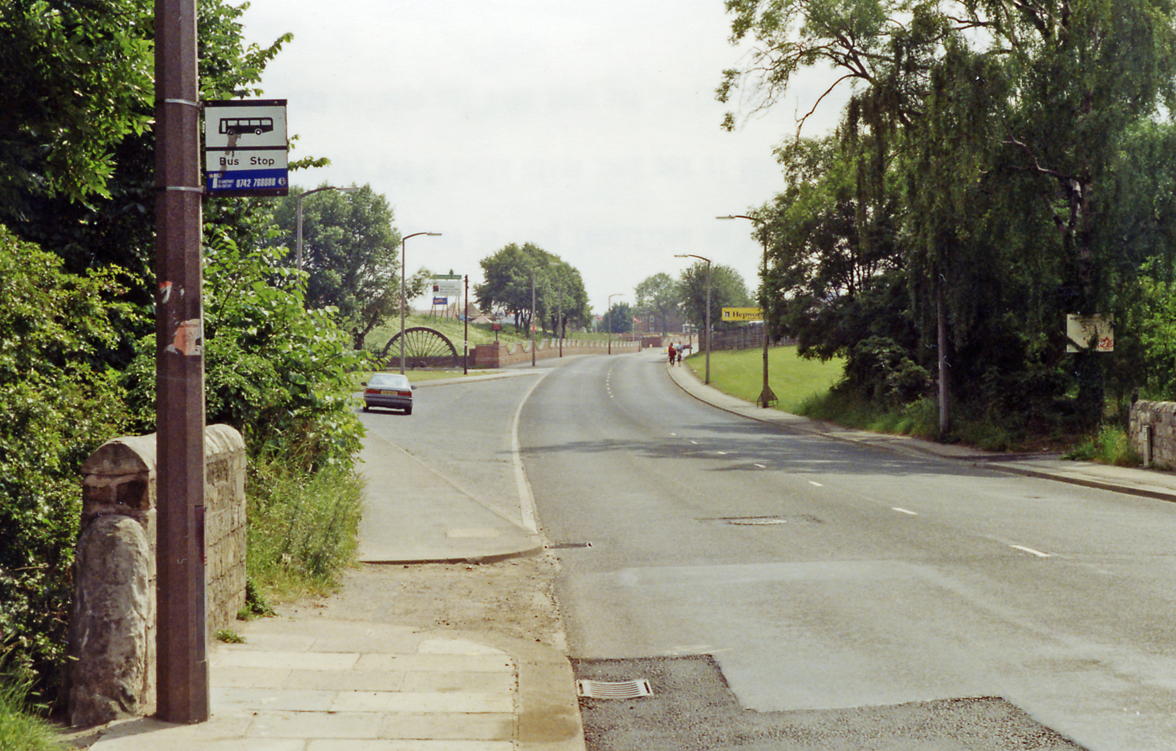
Transportation in Warmsworth is convenient, with good road connections to nearby towns and cities. The A1(M) motorway is easily accessible, linking the village to Doncaster, Sheffield, and Leeds. Additionally, there are regular bus services connecting Warmsworth to the wider area.

In summary, Warmsworth is a charming civil parish in Yorkshire, offering a peaceful residential environment with a range of amenities and access to beautiful countryside.

If you have any feedback on the listing, please let us know in the comments section below.
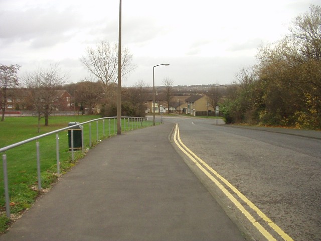
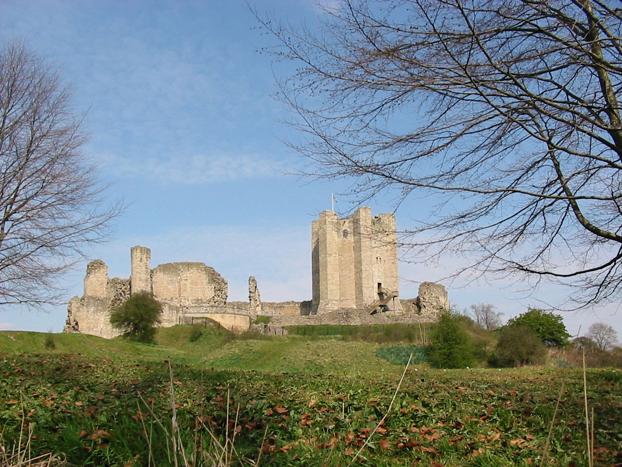
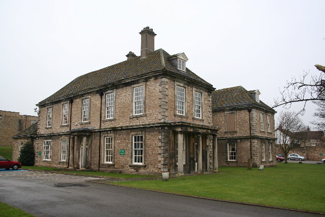
Warmsworth Images

Images are sourced within 2km of 53.499143/-1.181817 or Grid Reference SE5400. Thanks to Geograph Open Source API. All images are credited.

Rainbow Bridge Functioning railway bridge crossing The River Don near Conisbrough
Rainbow Bridge
Functioning railway bridge crossing The River Don near Conisbrough
Edlington Halt railway station (site), Yorkshire Opened in 1912 by the Lancashire & Yorkshire Railway as the terminus of their Dearne Valley Railway from Wakefield Kirkgate, this station closed in 1951. The halts on this line were apparently made of old sleepers with an old railway carriage for shelter. Some later excursion trains ran from here until 1966.
The line was on an embankment and crossed over the main road by bridge, running parallel to and above the side road, being also partly over what is now the fire station. A sloping path led up to the station from the far left of this image. All trace of the railway has been obliterated.
Edlington Halt railway station (site), Yorkshire
Opened in 1912 by the Lancashire & Yorkshire Railway as the terminus of their Dearne Valley Railway from Wakefield Kirkgate, this station closed in 1951. The halts on this line were apparently made of old sleepers with an old railway carriage for shelter. Some later excursion trains ran from here until 1966. The line was on an embankment and crossed over the main road by bridge, running parallel to and above the side road, being also partly over what is now the fire station. A sloping path led up to the station from the far left of this image. All trace of the railway has been obliterated.
Cricket Without Balls The sign on the wall to the right states 'No ball games to be played on this grass area'.  Perhaps it doesn't include the cricket pitch?
Cricket Without Balls
The sign on the wall to the right states 'No ball games to be played on this grass area'. Perhaps it doesn't include the cricket pitch?
Red Brick Church Sitting on the southern edge of this square both the church and the road are dedicated to St John.  The blue sign points to a recreation ground.
Red Brick Church
Sitting on the southern edge of this square both the church and the road are dedicated to St John. The blue sign points to a recreation ground.
20 Red Bump This lonely looking speed bump reminds drivers that the limit is 20mph.  The housing was originally built to house the families and miners of the nearby coal mine.
20 Red Bump
This lonely looking speed bump reminds drivers that the limit is 20mph. The housing was originally built to house the families and miners of the nearby coal mine.
A1(M) to J36 This section of the A1 is designated motorway status as it passes Doncaster.  The sign is for J36 which is in the next square north and west of this one.
A1(M) to J36
This section of the A1 is designated motorway status as it passes Doncaster. The sign is for J36 which is in the next square north and west of this one.
Across the Don Valley from the Trans Pennine Trail. The white outcrop is a quarry (one of many around here) mining Dolomitic limestone.
Across the Don Valley from the Trans Pennine Trail.
The white outcrop is a quarry (one of many around here) mining Dolomitic limestone.
Railway bridge over River Don
Winding wheel from Yorkshire Main Colliery 1911 to 1985 In the background is the fire station and the wheel is at the entrance to the Yorkshire Main miners welfare club Edlington Doncaster.
Winding wheel from Yorkshire Main Colliery 1911 to 1985
In the background is the fire station and the wheel is at the entrance to the Yorkshire Main miners welfare club Edlington Doncaster.
Water tower on Sheffield Road Conisbrough Built 1951.
Water tower on Sheffield Road Conisbrough
Built 1951.
Disused railway bridge on Lords Head Lane
Entrance to Bridgeacre Nursery On Bromhouse Lane.
Entrance to Bridgeacre Nursery
On Bromhouse Lane.
River Don The Don Valley looking towards Doncaster as seen from Conisbrough viaduct.
River Don
The Don Valley looking towards Doncaster as seen from Conisbrough viaduct.
Rainbow Bridge Railway bridge over the River Don, seen from the Trans Pennine Trail
Rainbow Bridge
Railway bridge over the River Don, seen from the Trans Pennine Trail
Trans Pennine Trail Long distance shared use path near Rainbow Bridge
Trans Pennine Trail
Long distance shared use path near Rainbow Bridge
Former Railway Bridge Site of former Dearne Valley Railway bridge at Alverley Grange.
Former Railway Bridge
Site of former Dearne Valley Railway bridge at Alverley Grange.
Warmsworth Halt View along Warmsworth Halt towards Edlington Lane. This was once the site of Warmsworth Junction on the Hull & Barnsley/Great Central Joint railway
Warmsworth Halt
View along Warmsworth Halt towards Edlington Lane. This was once the site of Warmsworth Junction on the Hull & Barnsley/Great Central Joint railway
A1M southbound
A1M southbound
Show me another place!

Warmsworth is located at Grid Ref: SE5400 (Lat: 53.499143, Lng: -1.181817)

Division: West Riding

Administrative County: South Yorkshire

District: Doncaster

Police Authority: South Yorkshire

What 3 Words

///specifies.cured.lofts. Near Conisbrough, South Yorkshire

Nearby Locations

Warmsworth Warmsworth

Related Wikis

Warmsworth railway station

Warmsworth railway station was a railway station to serve the village of Warmsworth, South Yorkshire, England and was on the Hull and Barnsley and Great...

Levitt Hagg

Levitt Hagg (sometimes spelled Levit Hagg or Levett Hagg ) is an abandoned hamlet in South Yorkshire, located approximately two miles southwest of Doncaster...

Warmsworth

Warmsworth is a village and civil parish of Doncaster in the City of Doncaster in South Yorkshire, England. Its population was estimated at 3,908 in 2019...

Sprotborough (SYR) railway station

Sprotborough (SYR) railway station was situated on the South Yorkshire Railway's line between Doncaster Cherry Tree Lane and Conisbrough. The station was...

Don Gorge

The Don Gorge is the valley of the River Don to the west of Doncaster, south of the village of Sprotbrough. The gorge is known as a 'green corridor'. A...

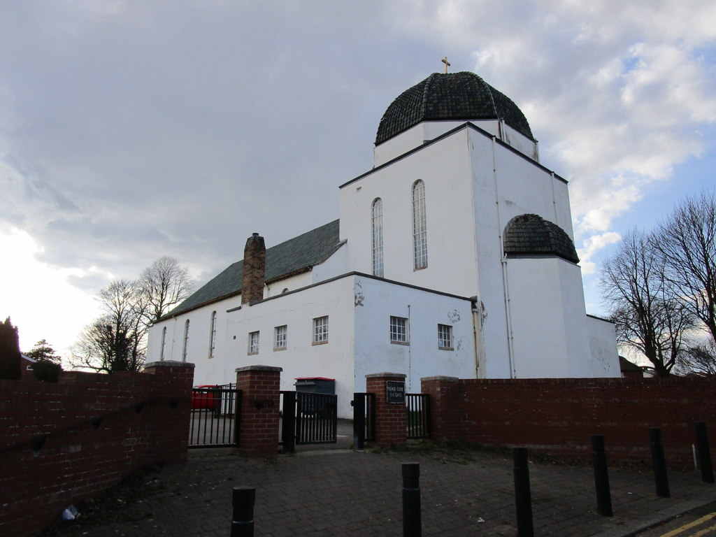
St Peter's Church, Warmsworth

St Peter's Church is the parish church of Warmsworth, south-west of Doncaster in South Yorkshire, in England. The original St Peter's Church was Mediaeval...

Edlington railway station

Edlington railway station was a small railway station at the eastern terminus of the Dearne Valley Railway. The station's full title as shown on the station...

Yorkshire Main F.C.

Yorkshire Main Football Club is a football club based in Edlington, Doncaster, South Yorkshire, England. They play in the Central Midlands League North...

Nearby Amenities

Located within 500m of 53.499143,-1.181817
Warmsworth
Place: suburb
Lat/Long: 53.5000184/-1.1823131
Traffic Signals
Fixme: more complex, N->E filters w/o light
Odbl: clean
Source: survey
Lat/Long: 53.4978659/-1.1824994
Traffic Signals
Lat/Long: 53.4977593/-1.1824354
Bus Stop
Mill Lane/Cliff Crescent
Alt Name: Mill Lane/Cliff Crescent
Naptan AltCommonName: Mill Lane/Cliff Crescent
Naptan AtcoCode: 370040236
Naptan Bearing: N
Naptan CommonName: Mill Lane/Cliff Crescent
Naptan Indicator: 40236
Naptan Landmark: School
Naptan PlusbusZoneRef: ROTHCEN
Naptan Street: Mill Lane
Naptan Verified: no
Source: naptan_import
Lat/Long: 53.4992839/-1.183384
Bus Stop
Lords Head Lane/Edlington Lane
Naptan AtcoCode: 370040237
Naptan Bearing: N
Naptan CommonName: Lords Head Lane/Edlington Lane
Naptan Indicator: 40237
Naptan Landmark: Opposite House Number 27
Naptan PlusbusZoneRef: ROTHCEN
Naptan Street: Lords Head Lane
Naptan Verified: no
Source: naptan_import
Lat/Long: 53.4951679/-1.1811211
Bus Stop
Tenter Lane/Mill Lane
Bus: yes
Naptan AtcoCode: 370040238
Naptan Bearing: E
Naptan CommonName: Tenter Lane/Mill Lane
Naptan Indicator: 40238
Naptan Landmark: Streetlight No 15052
Naptan PlusbusZoneRef: ROTHCEN
Naptan Street: Tenter Lane
Naptan Verified: no
Public Transport: platform
Source: naptan_import
Lat/Long: 53.500985/-1.1839338
Bus Stop
Mill Lane/Mayflower Drive
Alt Name: Mill Lane/Mayflower Drive
Naptan AltCommonName: Mill Lane/Mayflower Drive
Naptan AtcoCode: 370040239
Naptan Bearing: N
Naptan CommonName: Mill Lane/Mayflower Drive
Naptan Indicator: 40239
Naptan Landmark: Outside Warmsworth Youth Centr
Naptan PlusbusZoneRef: ROTHCEN
Naptan Street: Mill Lane
Naptan Verified: no
Source: naptan_import
Lat/Long: 53.4990398/-1.1834028
Bus Stop
Tenter Lane/Tenter Road
Bus: yes
Naptan AtcoCode: 370040240
Naptan Bearing: NE
Naptan CommonName: Tenter Lane/Tenter Road
Naptan Indicator: 40240
Naptan Landmark: 40240
Naptan PlusbusZoneRef: ROTHCEN
Naptan Street: Tenter Lane
Naptan Verified: no
Public Transport: platform
Source: naptan_import
Lat/Long: 53.5017054/-1.180181
Bus Stop
Tenter Lane/Tenter Road
Bus: yes
Naptan AtcoCode: 370040241
Naptan Bearing: SW
Naptan CommonName: Tenter Lane/Tenter Road
Naptan Indicator: 40241
Naptan Landmark: 40241
Naptan PlusbusZoneRef: ROTHCEN
Naptan Street: Tenter Lane
Naptan Verified: no
Public Transport: platform
Source: naptan_import
Lat/Long: 53.5016751/-1.179684
Bus Stop
Tenter Lane/Coldstream Avenue
Bus: yes
Naptan AtcoCode: 370040242
Naptan Bearing: NE
Naptan CommonName: Tenter Lane/Coldstream Avenue
Naptan Indicator: 40242
Naptan Landmark: O/S House No 99
Naptan PlusbusZoneRef: ROTHCEN
Naptan Street: Tenter Lane
Naptan Verified: no
Public Transport: platform
Source: naptan_import
Lat/Long: 53.5023731/-1.1779216
Bus Stop
Badsworth Road/Low Road West
Naptan AtcoCode: 370040244
Naptan Bearing: N
Naptan CommonName: Badsworth Road/Low Road West
Naptan Indicator: 40244
Naptan Landmark: 40244
Naptan PlusbusZoneRef: ROTHCEN
Naptan Street: Badsworth Road
Naptan Verified: no
Source: naptan_import
Lat/Long: 53.4978176/-1.1795022
Bus Stop
Edlington Lane/Sheffield Road
Alt Name: Edlington Lane/Sheffield Road
Naptan AltCommonName: Edlington Lane/Sheffield Road
Naptan AtcoCode: 370040246
Naptan Bearing: N
Naptan CommonName: Edlington Lane/Sheffield Road
Naptan Indicator: 40246
Naptan Landmark: Streetlight No 14559
Naptan PlusbusZoneRef: ROTHCEN
Naptan Street: Edlington Lane
Naptan Verified: no
Source: naptan_import
Lat/Long: 53.4968287/-1.1821142
Bus Stop
Edlington Lane/Sheffield Road
Alt Name: Edlington Lane/Sheffield Road
Naptan AltCommonName: Edlington Lane/Sheffield Road
Naptan AtcoCode: 370045161
Naptan Bearing: S
Naptan CommonName: Edlington Lane/Sheffield Road
Naptan Indicator: 45161
Naptan Landmark: Streetlight No 14560
Naptan PlusbusZoneRef: ROTHCEN
Naptan Street: Edlington Lane
Naptan Verified: no
Source: naptan_import
Lat/Long: 53.4971065/-1.1819882
Bus Stop
High Road/Quaker Lane
Alt Name: High Road/Quaker Lane
Naptan AltCommonName: High Road/Quaker Lane
Naptan AtcoCode: 370045418
Naptan Bearing: SW
Naptan CommonName: High Road/Quaker Lane
Naptan Indicator: 45418
Naptan Landmark: 45418
Naptan PlusbusZoneRef: ROTHCEN
Naptan Street: High Road
Naptan Verified: no
Source: naptan_import
Lat/Long: 53.4996636/-1.1798891
Bus Stop
High Road/Tenter Road
Alt Name: High Road/Tenter Road
Naptan AltCommonName: High Road/Tenter Road
Naptan AtcoCode: 370045419
Naptan Bearing: NE
Naptan CommonName: High Road/Tenter Road
Naptan Indicator: 45419
Naptan Landmark: 45419
Naptan PlusbusZoneRef: ROTHCEN
Naptan Street: High Road
Naptan Verified: no
Source: naptan_import
Lat/Long: 53.499895/-1.179643
Bus Stop
Sheffield Road/Mill Lane
Alt Name: Sheffield Road/Mill Lane
Naptan AltCommonName: Sheffield Road/Mill Lane
Naptan AtcoCode: 370045420
Naptan Bearing: NE
Naptan CommonName: Sheffield Road/Mill Lane
Naptan Indicator: 45420
Naptan Landmark: POST OFFICE
Naptan PlusbusZoneRef: ROTHCEN
Naptan Street: Sheffield Road
Naptan Verified: no
Shelter: yes
Source: naptan_import
Lat/Long: 53.4973141/-1.1834314
Bus Stop
Stapleton Road/Darrington Drive
Alt Name: Stapleton Road/Darrington Drive
Naptan AltCommonName: Stapleton Road/Darrington Drive
Naptan AtcoCode: 370045421
Naptan Bearing: SE
Naptan CommonName: Stapleton Road/Darrington Drive
Naptan Indicator: 45421
Naptan Landmark: Warmsworth Playing Fields
Naptan PlusbusZoneRef: ROTHCEN
Naptan Street: Stapleton Road
Naptan Verified: no
Source: naptan_import
Lat/Long: 53.4970259/-1.1767889
Bus Stop
Tenter Lane/Mill Lane
Bus: yes
Naptan AtcoCode: 370045992
Naptan Bearing: W
Naptan BusStopType: CUS
Naptan CommonName: Tenter Lane/Mill Lane
Naptan Indicator: 45992
Naptan Landmark: 45992
Naptan PlusbusZoneRef: ROTHCEN
Naptan Street: Tenter Lane
Naptan Verified: no
Public Transport: platform
Source: naptan_import
Lat/Long: 53.5008859/-1.1838905
Bus Stop
Tenter Lane/Coldstream Avenue
Bus: yes
Naptan AtcoCode: 370045993
Naptan Bearing: SW
Naptan BusStopType: CUS
Naptan CommonName: Tenter Lane/Coldstream Avenue
Naptan Indicator: 45993
Naptan Landmark: O/S HOUSE NO 99
Naptan PlusbusZoneRef: ROTHCEN
Naptan Street: Tenter Lane
Naptan Verified: no
Public Transport: platform
Source: naptan_import
Lat/Long: 53.502283/-1.1778932
Bus Stop
Sheffield Road/Cecil Avenue
Alt Name: Sheffield Road/Cecil Avenue
Naptan AltCommonName: Sheffield Road/Cecil Avenue
Naptan AtcoCode: 370045605
Naptan Bearing: SW
Naptan CommonName: Sheffield Road/Cecil Avenue
Naptan Indicator: 45605
Naptan Landmark: 45605
Naptan PlusbusZoneRef: ROTHCEN
Naptan Street: Sheffield Road
Naptan Verified: no
Source: naptan_import
Lat/Long: 53.4968125/-1.1836823
Check Date: 2024-01-07
Disused Emergency: phone
Ref: 9149 A
Lat/Long: 53.5005222/-1.1749402
Crossing
Lat/Long: 53.4995539/-1.1802771
Barrier: kissing_gate
Lat/Long: 53.500589/-1.1853384
Man Made: tower
Tower Construction: stone
Tower Type: bell_tower
Lat/Long: 53.4991947/-1.1756109
Holiday Inn
Addr City: Doncaster
Addr Country: GB
Addr Postcode: DN4 9UX
Addr Street: High Road
Addr Suburb: Warmsworth
Brand: Holiday Inn
Brand Wikidata: Q2717882
Brand Wikipedia: en:Holiday Inn
Fhrs Id: 996748
Tourism: hotel
Lat/Long: 53.499621/-1.1772285
Number One Super Convenience Store
Shop: convenience
Lat/Long: 53.4983075/-1.1830731
Crossing
Lat/Long: 53.497624/-1.1826562
Crossing
Lat/Long: 53.4977523/-1.182668
Post Box
Post Box Type: pillar
Lat/Long: 53.4982741/-1.1829819
Generator Method: photovoltaic
Generator Output Electricity: yes
Generator Source: solar
Generator Type: solar_photovoltaic_panel
Location: roof
Power: generator
Lat/Long: 53.495856/-1.18414
Generator Method: photovoltaic
Generator Output Electricity: yes
Generator Source: solar
Generator Type: solar_photovoltaic_panel
Location: roof
Power: generator
Lat/Long: 53.4961947/-1.1774384
Generator Method: photovoltaic
Generator Output Electricity: yes
Generator Source: solar
Generator Type: solar_photovoltaic_panel
Location: roof
Power: generator
Lat/Long: 53.5010036/-1.1841546
Generator Method: photovoltaic
Generator Output Electricity: yes
Generator Source: solar
Generator Type: solar_photovoltaic_panel
Location: roof
Power: generator
Lat/Long: 53.5011041/-1.1845194
Generator Method: photovoltaic
Generator Output Electricity: yes
Generator Source: solar
Generator Type: solar_photovoltaic_panel
Location: roof
Power: generator
Lat/Long: 53.501546/-1.1835753
Generator Method: photovoltaic
Generator Output Electricity: yes
Generator Source: solar
Generator Type: solar_photovoltaic_panel
Location: roof
Power: generator
Lat/Long: 53.5003255/-1.1804559
Generator Method: photovoltaic
Generator Output Electricity: yes
Generator Source: solar
Generator Type: solar_photovoltaic_panel
Location: roof
Power: generator
Lat/Long: 53.5025814/-1.1796593
Generator Method: photovoltaic
Generator Output Electricity: yes
Generator Source: solar
Generator Type: solar_photovoltaic_panel
Location: roof
Power: generator
Lat/Long: 53.5028271/-1.1809682
Generator Method: photovoltaic
Generator Output Electricity: yes
Generator Source: solar
Generator Type: solar_photovoltaic_panel
Location: roof
Power: generator
Lat/Long: 53.5023357/-1.1817809
Generator Method: photovoltaic
Generator Output Electricity: yes
Generator Source: solar
Generator Type: solar_photovoltaic_panel
Location: roof
Power: generator
Lat/Long: 53.4997705/-1.1828946
Generator Method: photovoltaic
Generator Output Electricity: yes
Generator Source: solar
Generator Type: solar_photovoltaic_panel
Location: roof
Power: generator
Lat/Long: 53.4998676/-1.1824662
Generator Method: photovoltaic
Generator Output Electricity: yes
Generator Source: solar
Generator Type: solar_photovoltaic_panel
Location: roof
Power: generator
Lat/Long: 53.4994871/-1.1826633
Generator Method: photovoltaic
Generator Output Electricity: yes
Generator Source: solar
Generator Type: solar_photovoltaic_panel
Location: roof
Power: generator
Lat/Long: 53.4993116/-1.1814322
Barrier: kissing_gate
Lat/Long: 53.501603/-1.1867673
Camera Mount: pole
Camera Type: dome
Man Made: surveillance
Surveillance: public
Surveillance Type: camera
Surveillance Zone: town
Lat/Long: 53.4980563/-1.1824592
Traffic Signals
Traffic Signals: signal
Lat/Long: 53.5006677/-1.1756917
Traffic Signals
Traffic Signals: signal
Lat/Long: 53.5007169/-1.1758852
Post Office
Warmsworth Post Office
Addr City: Doncaster
Addr Country: GB
Addr Housenumber: 1
Addr Postcode: DN4 9RG
Addr Street: Mill Lane
Addr Suburb: Warmsworth
Brand: Post Office
Brand Wikidata: Q1783168
Check Date: 2022-05-27
Opening Hours: Mo-Su 07:30-17:00
Ref Pol Id: 119825
Lat/Long: 53.4982802/-1.1830187
The data included in this document is from www.openstreetmap.org. The data is made available under ODbL.

Have you been to Warmsworth?

Leave your review of Warmsworth below (or comments, questions and feedback).