Thurcroft

Civil Parish in Yorkshire Rotherham

England

Thurcroft

Church of St Simon & St Jude Parish church built in 1937
Church of St Simon & St Jude Credit: Graham Hogg

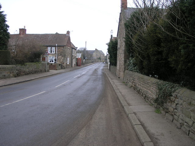
Thurcroft is a civil parish located in the county of Yorkshire, England. It is situated in the Metropolitan Borough of Rotherham and lies approximately 9 miles east of the town of Rotherham. The village is nestled within the beautiful South Yorkshire countryside, with rolling hills and picturesque landscapes surrounding it.

Thurcroft has a population of around 4,000 residents and is primarily a residential area. The village has a close-knit community feel, with various amenities and services available to cater to the needs of its residents. These include a primary school, a community center, a library, and a few local shops and businesses.

The village is well-connected to nearby towns and cities by a network of roads, with the A618 and A57 passing through the area. This makes it easily accessible for commuters and provides convenient access to the wider Yorkshire region.

Thurcroft is also known for its mining heritage, with several collieries once operating in the area. The village has a rich history, and remnants of its mining past can still be seen in some parts of the landscape.

Overall, Thurcroft offers a peaceful and scenic setting for its residents, with a range of amenities and good transport links. It is a place where residents can enjoy the tranquility of rural living while still being within reach of urban conveniences.

If you have any feedback on the listing, please let us know in the comments section below.
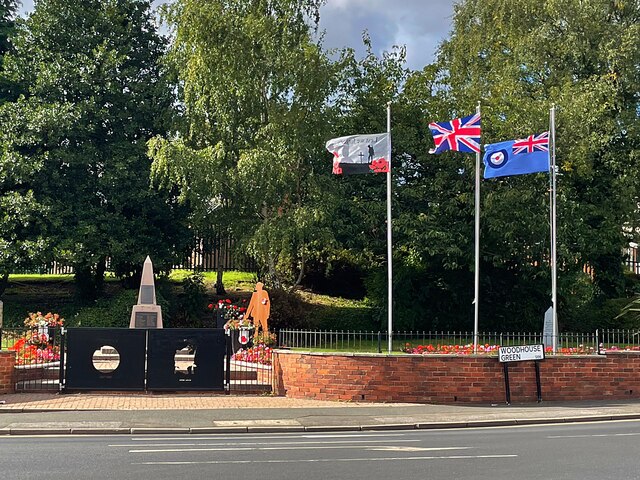
Thurcroft Images

Images are sourced within 2km of 53.389761/-1.25104 or Grid Reference SK4988. Thanks to Geograph Open Source API. All images are credited.

Church of St Simon & St Jude Parish church built in 1937
Church of St Simon & St Jude
Parish church built in 1937
Traffic signs at a road junction The junction of Long Road and Hawk Hill Lane
Traffic signs at a road junction
The junction of Long Road and Hawk Hill Lane
Thurcroft War Memorial
Early Autumn colour in Thurcroft Cemetery
Winding wheel The wheel is from Dinnington Colliery which closed in 1992.
Winding wheel
The wheel is from Dinnington Colliery which closed in 1992.
Brampton en le morthen village sign. On the northern edge of the village.
Brampton en le morthen village sign.
On the northern edge of the village.
Silver birch trees beside a footpath The footpath is on the line of the former railway to Thurcroft Main Colliery which closed in 1992.
Silver birch trees beside a footpath
The footpath is on the line of the former railway to Thurcroft Main Colliery which closed in 1992.
Tree tunnel on the Old Mineral Line Trail The Trail is a concessionary cycle way on the line of a former railway to Thurcroft Main Colliery
Tree tunnel on the Old Mineral Line Trail
The Trail is a concessionary cycle way on the line of a former railway to Thurcroft Main Colliery
Bridge over the Old Mineral Line Trail The Trail is on the former railway line to Thurcroft Main Colliery.
The bridge carries four public footpaths over the trail.
Bridge over the Old Mineral Line Trail
The Trail is on the former railway line to Thurcroft Main Colliery. The bridge carries four public footpaths over the trail.
Footpath, Laughton en le Morthen A pleasant path from School Road to the church.
Footpath, Laughton en le Morthen
A pleasant path from School Road to the church.
View towards Laughton Common The view direction is an approximate estimate.
View towards Laughton Common
The view direction is an approximate estimate.
View towards a business estate at Dinnington
Stile on the footpath to the church, Laughton en le Morthen This is on the same footpath as <a href="https://www.geograph.org.uk/photo/4720445">SK5187 : Footpath, Laughton en le Morthen</a>.
Stile on the footpath to the church, Laughton en le Morthen
This is on the same footpath as SK5187 : Footpath, Laughton en le Morthen.
Footpath gate at Church Corner, Laughton en le Morthen This is a short distance north of the stile in <a href="https://www.geograph.org.uk/photo/4720487">SK5188 : Stile on the footpath to the church, Laughton en le Morthen</a>.
Footpath gate at Church Corner, Laughton en le Morthen
This is a short distance north of the stile in SK5188 : Stile on the footpath to the church, Laughton en le Morthen.
Earthworks at Laughton en le Morthen Probably old quarries; I have not found a map showing anything here.
Earthworks at Laughton en le Morthen
Probably old quarries; I have not found a map showing anything here.
Carved head on All Saints Church, Laughton en le Morthen He heard me say 'Lafton'; apparently it should be 'Lawton'.
Carved head on All Saints Church, Laughton en le Morthen
He heard me say 'Lafton'; apparently it should be 'Lawton'.
South nave window, All Saints Church, Laughton en le Morthen The carved head on the right is this one: [<a href="https://www.geograph.org.uk/photo/4720497">SK5188 : Carved head on All Saints Church, Laughton en le Morthen</a>.
South nave window, All Saints Church, Laughton en le Morthen
The carved head on the right is this one: [SK5188 : Carved head on All Saints Church, Laughton en le Morthen.
The spire of All Saints Church, Laughton en le Morthen The spire is 56m tall, and was built in 1377.
The spire of All Saints Church, Laughton en le Morthen
The spire is 56m tall, and was built in 1377.
Show me another place!

Thurcroft is located at Grid Ref: SK4988 (Lat: 53.389761, Lng: -1.25104)

Division: West Riding

Administrative County: South Yorkshire

District: Rotherham

Police Authority: South Yorkshire

What 3 Words

///youth.workshops.tightest. Near Bramley, South Yorkshire

Nearby Locations

Thurcroft

Related Wikis

Thurcroft

Thurcroft is a village and civil parish situated south-east of Rotherham in the Metropolitan Borough of Rotherham in South Yorkshire, England. From 1902...
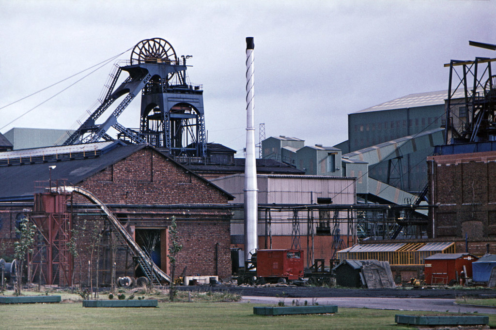
Thurcroft Colliery

Thurcroft Colliery was a coal mine situated in the village of Thurcroft, near Rotherham, South Yorkshire, England. In 1902, the Rother Vale Colliery Company...

Dinnington and Laughton railway station

Dinnington and Laughton railway station was situated on the South Yorkshire Joint Railway line between the town of Dinnington and village of Laughton-en...

Brampton-en-le-Morthen

Brampton-en-le-Morthen is a small dormitory village and former civil parish, now in the parish of Thurcroft, in the Rotherham district lying to the south...

Thurcroft Interchange

The Thurcroft Interchange is a large motorway junction in South Yorkshire (the Metropolitan Borough of Rotherham). == History == === M1 === Early designs...

Carr, South Yorkshire

Carr is a hamlet in the civil parish of Laughton-en-le-Morthen, in the Rotherham district lying to the south of Rotherham, South Yorkshire, England....

Slade Hooton

Slade Hooton is a hamlet in the Metropolitan Borough of Rotherham, in South Yorkshire, England. Historically in the West Riding of Yorkshire, the hamlet...

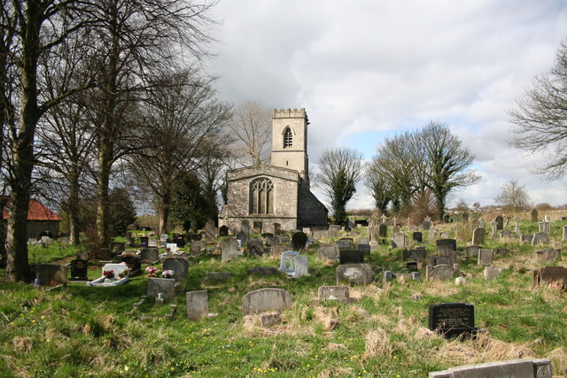
St John's Church, Throapham

St John's Church is a redundant Anglican church near the village of Throapham, on the road between Dinnington and Laughton-en-le-Morthen, South Yorkshire...

Nearby Amenities

Located within 500m of 53.389761,-1.25104
Bus Stop
Laughton Road/Clarke Avenue
Naptan AtcoCode: 370030134
Naptan Bearing: SE
Naptan CommonName: Laughton Road/Clarke Avenue
Naptan Indicator: 30134
Naptan Landmark: 30134
Naptan PlusbusZoneRef: ROTHCEN
Naptan Street: Laughton Road
Naptan Verified: no
Source: naptan_import
Lat/Long: 53.3922135/-1.2475658
Bus Stop
Laughton Road/Clarke Avenue
Naptan AtcoCode: 370030135
Naptan Bearing: NW
Naptan CommonName: Laughton Road/Clarke Avenue
Naptan Indicator: 30135
Naptan Landmark: 30135
Naptan PlusbusZoneRef: ROTHCEN
Naptan Street: Laughton Road
Naptan Verified: no
Source: naptan_import
Lat/Long: 53.3919157/-1.2473755
Bus Stop
School Road/Green Arbour Road
Naptan AtcoCode: 370030004
Naptan Bearing: SW
Naptan CommonName: School Road/Green Arbour Road
Naptan Indicator: 30004
Naptan Landmark: Thurcroft Junior School
Naptan PlusbusZoneRef: ROTHCEN
Naptan Street: School Road
Naptan Verified: no
Source: naptan_import
Lat/Long: 53.3923409/-1.2549772
Bus Stop
Green Arbour Road/Limetree Avenue
Alt Name: Green Arbour Road/Limetree Avenue
Naptan AltCommonName: Green Arbour Road/Limetree Avenue
Naptan AtcoCode: 370030005
Naptan Bearing: S
Naptan CommonName: Green Arbour Road/Limetree Avenue
Naptan Indicator: 30005
Naptan Landmark: BURMAH GARAGE
Naptan PlusbusZoneRef: ROTHCEN
Naptan Street: Green Arbour Road
Naptan Verified: no
Source: naptan_import
Lat/Long: 53.3907892/-1.2569591
Bus Stop
Green Arbour Road/Toad Lane
Alt Name: Green Arbour Road/Toad Lane
Naptan AltCommonName: Green Arbour Road/Toad Lane
Naptan AtcoCode: 370030006
Naptan Bearing: NW
Naptan CommonName: Green Arbour Road/Toad Lane
Naptan Indicator: 30006
Naptan Landmark: GREEN ARBOUR FARM
Naptan PlusbusZoneRef: ROTHCEN
Naptan Street: Green Arbour Road
Naptan Verified: no
Source: naptan_import
Lat/Long: 53.3887093/-1.2549654
Bus Stop
Green Arbour Road/Cemetery
Naptan AtcoCode: 370030009
Naptan Bearing: S
Naptan CommonName: Green Arbour Road/Cemetery
Naptan Indicator: 30009
Naptan Landmark: OUTSIDE CEMETERY
Naptan PlusbusZoneRef: ROTHCEN
Naptan Street: Green Arbour Road
Naptan Verified: no
Source: naptan_import
Lat/Long: 53.386429/-1.2525694
Bus Stop
School Road/Laughton Road
Naptan AtcoCode: 370030334
Naptan Bearing: E
Naptan CommonName: School Road/Laughton Road
Naptan Indicator: 30334
Naptan Landmark: OPPOSITE HOUSE NUMBER 74
Naptan PlusbusZoneRef: ROTHCEN
Naptan Street: School Road
Naptan Verified: no
Source: naptan_import
Lat/Long: 53.3931767/-1.2506316
Bus Stop
Laughton Road/School Road
Alt Name: Laughton Road/School Road
Naptan AltCommonName: Laughton Road/School Road
Naptan AtcoCode: 370035081
Naptan Bearing: N
Naptan CommonName: Laughton Road/School Road
Naptan Indicator: 35081
Naptan Landmark: 35081
Naptan PlusbusZoneRef: ROTHCEN
Naptan Street: Laughton Road
Naptan Verified: no
Source: naptan_import
Lat/Long: 53.3931136/-1.249174
Bus Stop
Green Arbour Road/Cemetery
Naptan AtcoCode: 370035083
Naptan Bearing: N
Naptan CommonName: Green Arbour Road/Cemetery
Naptan Indicator: 35083
Naptan Landmark: Opposite Cemetery
Naptan PlusbusZoneRef: ROTHCEN
Naptan Street: Green Arbour Road
Naptan Verified: no
Source: naptan_import
Lat/Long: 53.3861702/-1.2528596
Bus Stop
Green Arbour Road/Ivanhoe Road
Naptan AtcoCode: 370035185
Naptan Bearing: N
Naptan CommonName: Green Arbour Road/Ivanhoe Road
Naptan Indicator: 35185
Naptan Landmark: BURMAH GARAGE
Naptan PlusbusZoneRef: ROTHCEN
Naptan Street: Green Arbour Road
Naptan Verified: no
Source: naptan_import
Lat/Long: 53.390863/-1.2572736
Bus Stop
Green Arbour Road/Toad Lane
Alt Name: Green Arbour Road/Toad Lane
Naptan AltCommonName: Green Arbour Road/Toad Lane
Naptan AtcoCode: 370035687
Naptan Bearing: SE
Naptan BusStopType: CUS
Naptan CommonName: Green Arbour Road/Toad Lane
Naptan Indicator: 35687
Naptan Landmark: GREEN ARBOUR FARM
Naptan PlusbusZoneRef: ROTHCEN
Naptan Street: Green Arbour Road
Naptan Verified: no
Source: naptan_import
Lat/Long: 53.3887888/-1.2547535
Bus Stop
School Road
Alt Name: School Road
Naptan AltCommonName: School Road
Naptan AtcoCode: 370035692
Naptan Bearing: NE
Naptan BusStopType: CUS
Naptan CommonName: School Road
Naptan Indicator: 35692
Naptan Landmark: THURCROFT JUNIOR SCHOOL
Naptan PlusbusZoneRef: ROTHCEN
Naptan Street: School Road
Naptan Verified: no
Source: naptan_import
Lat/Long: 53.3924941/-1.2550788
Power: pole
Lat/Long: 53.3864918/-1.24751
Power: pole
Lat/Long: 53.3869639/-1.2487523
Power: pole
Lat/Long: 53.3873885/-1.2499101
Power: pole
Lat/Long: 53.3878177/-1.2510846
Power: pole
Lat/Long: 53.3882158/-1.2521411
Power: pole
Lat/Long: 53.3886039/-1.2531938
Power: pole
Lat/Long: 53.3889369/-1.2541143
Post Box
Collection Times: Mo-Fr 09:00; Sa 07:00
Post Box Type: lamp
Ref: S66 203
Royal Cypher: EIIR
Royal Cypher Wikidata: Q33102113
Lat/Long: 53.3932772/-1.2495547
Post Box
Collection Times: Mo-Fr 09:00; Sa 07:00
Post Box Type: wall
Ref: S66 141
Royal Cypher: GR
Royal Cypher Wikidata: Q33102273
Lat/Long: 53.3911231/-1.2570198
Barrier: kissing_gate
Lat/Long: 53.3892957/-1.2566283
Generator Method: photovoltaic
Generator Output Electricity: yes
Generator Source: solar
Generator Type: solar_photovoltaic_panel
Location: roof
Power: generator
Lat/Long: 53.3927167/-1.2489036
Generator Method: photovoltaic
Generator Output Electricity: yes
Generator Source: solar
Generator Type: solar_photovoltaic_panel
Location: roof
Power: generator
Lat/Long: 53.3927247/-1.2489733
Generator Method: photovoltaic
Generator Output Electricity: yes
Generator Source: solar
Generator Type: solar_photovoltaic_panel
Location: roof
Power: generator
Lat/Long: 53.3927023/-1.2460122
Generator Method: photovoltaic
Generator Output Electricity: yes
Generator Source: solar
Generator Type: solar_photovoltaic_panel
Location: roof
Power: generator
Lat/Long: 53.3924112/-1.2452289
Generator Method: photovoltaic
Generator Output Electricity: yes
Generator Source: solar
Generator Type: solar_photovoltaic_panel
Location: roof
Power: generator
Lat/Long: 53.3921137/-1.2450627
Generator Method: photovoltaic
Generator Output Electricity: yes
Generator Source: solar
Generator Type: solar_photovoltaic_panel
Location: roof
Power: generator
Lat/Long: 53.3920961/-1.2452209
Generator Method: photovoltaic
Generator Output Electricity: yes
Generator Source: solar
Generator Type: solar_photovoltaic_panel
Location: roof
Power: generator
Lat/Long: 53.3920801/-1.2454677
Generator Method: photovoltaic
Generator Output Electricity: yes
Generator Source: solar
Generator Type: solar_photovoltaic_panel
Location: roof
Power: generator
Lat/Long: 53.3910772/-1.2443894
Generator Method: photovoltaic
Generator Output Electricity: yes
Generator Source: solar
Generator Type: solar_photovoltaic_panel
Location: roof
Power: generator
Lat/Long: 53.3901111/-1.246798
Generator Method: photovoltaic
Generator Output Electricity: yes
Generator Source: solar
Generator Type: solar_photovoltaic_panel
Location: roof
Power: generator
Lat/Long: 53.3906869/-1.2470502
Generator Method: photovoltaic
Generator Output Electricity: yes
Generator Source: solar
Generator Type: solar_photovoltaic_panel
Location: roof
Power: generator
Lat/Long: 53.3906805/-1.2472031
Generator Method: photovoltaic
Generator Output Electricity: yes
Generator Source: solar
Generator Type: solar_photovoltaic_panel
Location: roof
Power: generator
Lat/Long: 53.3906853/-1.2473774
Generator Method: photovoltaic
Generator Output Electricity: yes
Generator Source: solar
Generator Type: solar_photovoltaic_panel
Location: roof
Power: generator
Lat/Long: 53.3906901/-1.2476751
Generator Method: photovoltaic
Generator Output Electricity: yes
Generator Source: solar
Generator Type: solar_photovoltaic_panel
Location: roof
Power: generator
Lat/Long: 53.3906805/-1.2479138
Generator Method: photovoltaic
Generator Output Electricity: yes
Generator Source: solar
Generator Type: solar_photovoltaic_panel
Location: roof
Power: generator
Lat/Long: 53.3924784/-1.2541902
Generator Method: photovoltaic
Generator Output Electricity: yes
Generator Source: solar
Generator Type: solar_photovoltaic_panel
Location: roof
Power: generator
Lat/Long: 53.3927599/-1.2523019
Generator Method: photovoltaic
Generator Output Electricity: yes
Generator Source: solar
Generator Type: solar_photovoltaic_panel
Location: roof
Power: generator
Lat/Long: 53.3931598/-1.2525326
Generator Method: photovoltaic
Generator Output Electricity: yes
Generator Source: solar
Generator Type: solar_photovoltaic_panel
Location: roof
Power: generator
Lat/Long: 53.3920369/-1.2561053
Generator Method: photovoltaic
Generator Output Electricity: yes
Generator Source: solar
Generator Type: solar_photovoltaic_panel
Location: roof
Power: generator
Lat/Long: 53.3915267/-1.2557995
Generator Method: photovoltaic
Generator Output Electricity: yes
Generator Source: solar
Generator Type: solar_photovoltaic_panel
Location: roof
Power: generator
Lat/Long: 53.3907141/-1.2553436
Generator Method: photovoltaic
Generator Output Electricity: yes
Generator Source: solar
Generator Type: solar_photovoltaic_panel
Location: roof
Power: generator
Lat/Long: 53.3894329/-1.2576878
Generator Method: photovoltaic
Generator Output Electricity: yes
Generator Source: solar
Generator Type: solar_photovoltaic_panel
Location: roof
Power: generator
Lat/Long: 53.3903734/-1.2582484
The data included in this document is from www.openstreetmap.org. The data is made available under ODbL.

Have you been to Thurcroft?

Leave your review of Thurcroft below (or comments, questions and feedback).