Thornton

Civil Parish in Lancashire Sefton

England

Thornton

Lunt Meadows Nature Reserve
Lunt Meadows Nature Reserve Credit: Mike Pennington

Thornton, Lancashire is a civil parish located in the Wyre district of Lancashire, England. It is situated on the Fylde coastal plain, approximately 5 miles northeast of Blackpool. The parish covers an area of around 10 square miles and has a population of approximately 13,000 people.

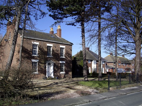
The village of Thornton is the main settlement within the parish and serves as a local center for amenities and services. It has a mix of residential and commercial properties, including shops, pubs, and restaurants. The village is known for its traditional architecture, with many buildings dating back to the 19th century.

Thornton is surrounded by agricultural land and has a rural feel, with several farms located in the area. The parish is bordered by the River Wyre to the east and the M55 motorway to the south, providing convenient transport links to nearby towns and cities.

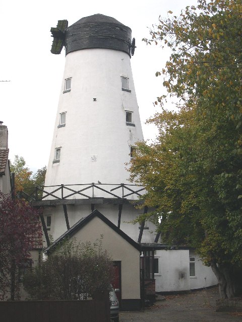
The parish has a number of notable landmarks and attractions. Marsh Mill, a Grade II* listed windmill built in 1794, is a prominent feature of the area. It is one of the tallest mills in Europe and is open to the public as a museum. Another popular site is Wyre Estuary Country Park, which offers scenic walking trails and birdwatching opportunities along the river.

Overall, Thornton, Lancashire is a charming civil parish with a mix of rural and residential areas. It offers a peaceful and picturesque setting, while still being within easy reach of larger towns and cities in the region.

If you have any feedback on the listing, please let us know in the comments section below.

Thornton Images

Images are sourced within 2km of 53.508381/-2.998353 or Grid Reference SD3301. Thanks to Geograph Open Source API. All images are credited.

Lunt Meadows Nature Reserve
River Alt at Lunt Meadows
Little Egret (Egretta garzetta), Lunt Meadows
Shoveler (Spatula clypeata), Lunt Meadows
Peacock (Inachis io), Lunt Meadows
Greenfinch (Carduelis chloris), Lunt Meadows
Great Crested Grebe (Podiceps cristatus), Lunt Meadows
Common Whitethroat (Sylvia communis), Lunt Meadows
Gateway to Ince Blundell Park. An entrance to Ince Blundell Park and Hall, the family home of the Weld-Blundells from the 1630's until the 1960's.
Gateway to Ince Blundell Park.
An entrance to Ince Blundell Park and Hall, the family home of the Weld-Blundells from the 1630's until the 1960's.
Windmill, Moor Lane, Crosby Dated 1813, this windmill still produced wholemeal flour for local bakeries until the 1970's.  It is now a private residence
Windmill, Moor Lane, Crosby
Dated 1813, this windmill still produced wholemeal flour for local bakeries until the 1970's. It is now a private residence
Windmill, Moor Lane, Crosby Unfortunately it no longer has its sails but otherwise it is in good original structural condition.
Windmill, Moor Lane, Crosby
Unfortunately it no longer has its sails but otherwise it is in good original structural condition.
Crosby Windmill Situated in Moor Lane. Built 1813 and converted into a residence some years ago. Unusually the stumps of the sail stocks are still bolted in place on the windshaft.
Crosby Windmill
Situated in Moor Lane. Built 1813 and converted into a residence some years ago. Unusually the stumps of the sail stocks are still bolted in place on the windshaft.
St  Helen's Better known as Sefton Church. First built around 1170 as a private chapel for the Molyneux family. Around 1320 the present tower was built, and the church was completed in the early 1500s.
St Helen's
Better known as Sefton Church. First built around 1170 as a private chapel for the Molyneux family. Around 1320 the present tower was built, and the church was completed in the early 1500s.
Sefton Mill Now used as a house, was a water powered corn-mill, part of the River Alt was diverted.
Sefton Mill
Now used as a house, was a water powered corn-mill, part of the River Alt was diverted.
The Punchbowl A very old pub in Sefton
The Punchbowl
A very old pub in Sefton
Sefton Church From Lunt
Sefton Church
From Lunt
Show me another place!

Thornton is located at Grid Ref: SD3301 (Lat: 53.508381, Lng: -2.998353)

Administrative County: Merseyside

District: Sefton

Police Authority: Merseyside

What 3 Words

///shaver.modifies.puts. Near Thornton, Merseyside

Related Wikis

Thornton, Merseyside

Thornton is a village in the Metropolitan Borough of Sefton, in Merseyside, England. Within the boundaries of the historic county of Lancashire and situated...

Lunt

Lunt is a small village in the civil parish of Sefton, in the borough of Sefton in Merseyside, England, close to Sefton Village and to the west of Maghull...

Holy Family Catholic High School, Thornton

Holy Family Catholic High School is a Catholic comprehensive school situated in Thornton, Merseyside, England, catering for mixed pupils aged 11–18. The...

Crosby Hall, Merseyside

Crosby Hall is situated in the ancient manor of Little Crosby, formerly in Lancashire. Close to the city of Liverpool in the modern county of Merseyside...

Nearby Amenities

Located within 500m of 53.508381,-2.998353
Crossing
Button Operated: yes
Crossing: traffic_signals
Crossing Island: no
Tactile Paving: no
Lat/Long: 53.5047359/-2.9969277
Barrier: motorcycle_barrier
Bicycle: yes
Foot: designated
Horse: yes
Lat/Long: 53.5049175/-2.99707
Historic: cross
Lat/Long: 53.5050467/-2.9974406
Barrier: stile
Bicycle: designated
Foot: designated
Horse: designated
Motor Vehicle: no
Lat/Long: 53.504537/-2.9970907
Crossing
Button Operated: yes
Crossing: traffic_signals
Crossing Island: no
Crossing Ref: toucan
Tactile Paving: yes
Lat/Long: 53.5047238/-2.9968046
Traffic Signals
Traffic Signals: crossing
Traffic Signals Direction: forward
Lat/Long: 53.5047168/-2.9967482
Traffic Signals
Traffic Signals: crossing
Traffic Signals Direction: backward
Lat/Long: 53.5047433/-2.9970065
The data included in this document is from www.openstreetmap.org. The data is made available under ODbL.

Have you been to Thornton?

Leave your review of Thornton below (or comments, questions and feedback).