Bryngwyn

Settlement in Cardiganshire

Wales

Bryngwyn

Narrow lane to Pen-y-banc From crossroads on Betws Ifan road
Narrow lane to Pen-y-banc Credit: John Firth

Bryngwyn is a small village located in the county of Cardiganshire, Wales. Situated in the beautiful rural landscape of mid-Wales, the village is nestled between rolling hills and lush green fields. With a population of approximately 300 residents, Bryngwyn is known for its close-knit community and peaceful atmosphere.

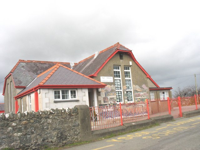
The village offers a range of amenities to cater to the needs of its residents. There is a local primary school, providing education for children in the area, as well as a village hall that serves as a hub for community gatherings and events. Additionally, there is a small convenience store where locals can purchase everyday essentials.

Bryngwyn boasts a rich history, with traces of its past visible in various landmarks and buildings. The village is home to a charming medieval church, St. David's Church, which dates back to the 13th century. This historical site attracts visitors interested in exploring the architectural heritage of the area.

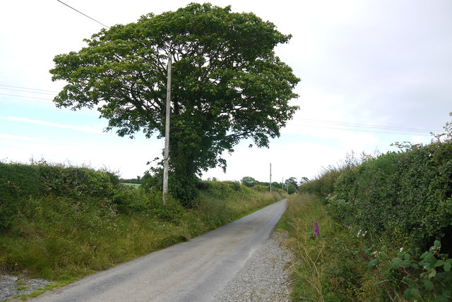
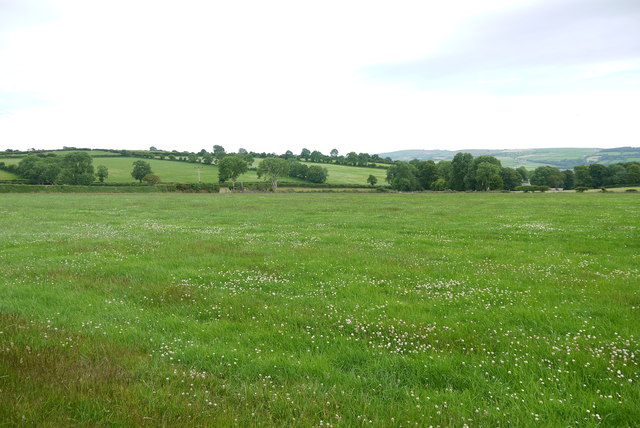
Nature enthusiasts will find plenty to admire in Bryngwyn, as the village is surrounded by stunning natural landscapes. The nearby countryside offers opportunities for walking, hiking, and cycling, allowing residents and visitors to immerse themselves in the beauty of the Welsh countryside.

Overall, Bryngwyn is a tranquil and picturesque village that offers a peaceful retreat from the hustle and bustle of city life. With its strong sense of community and stunning natural surroundings, it is a place that captures the essence of rural Wales.

If you have any feedback on the listing, please let us know in the comments section below.
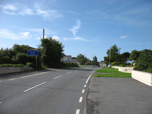
Bryngwyn Images

Images are sourced within 2km of 52.077323/-4.4805392 or Grid Reference SN3045. Thanks to Geograph Open Source API. All images are credited.

Narrow lane to Pen-y-banc From crossroads on Betws Ifan road
Narrow lane to Pen-y-banc
From crossroads on Betws Ifan road
Lane west from Pen-y-Banc
Ordnance Survey Cut Mark This OS cut mark can be found on a boulder behind the gate on the NE side of the road. It marks a point 138.088m above mean sea level.
Ordnance Survey Cut Mark
This OS cut mark can be found on a boulder behind the gate on the NE side of the road. It marks a point 138.088m above mean sea level.
Ordnance Survey Cut Mark This OS cut mark can be found on a disturbed boulder at the hedge junction NE side of the road. It marked a point 452.6ft above mean sea level.
Ordnance Survey Cut Mark
This OS cut mark can be found on a disturbed boulder at the hedge junction NE side of the road. It marked a point 452.6ft above mean sea level.
Country Lane near Panteinon This solitary oak tree is on the minor road between Brongwyn and Groesffordd about a mile north of Cwm Cou.
Country Lane near Panteinon
This solitary oak tree is on the minor road between Brongwyn and Groesffordd about a mile north of Cwm Cou.
Field at Groesffordd This lush pasture meadow is just off the minor road between Brongwyn and Groessffordd. The view is south towards Cilfallen.
Field at Groesffordd
This lush pasture meadow is just off the minor road between Brongwyn and Groessffordd. The view is south towards Cilfallen.
Entering Beulah On the B4333.
Entering Beulah
On the B4333.
Ordnance Survey Cut Mark This OS cut mark can be found on the wall at Blaen-y-ffynnon. It marks a point 155.351m above mean sea level.
Ordnance Survey Cut Mark
This OS cut mark can be found on the wall at Blaen-y-ffynnon. It marks a point 155.351m above mean sea level.
Ordnance Survey Rivet This OS rivet can be found on the concrete base in front of the house which was once a Smithy. It marks a point 155.846m above mean sea level.
Ordnance Survey Rivet
This OS rivet can be found on the concrete base in front of the house which was once a Smithy. It marks a point 155.846m above mean sea level.
Ordnance Survey Cut Mark This OS cut mark can be found on the stone at the road junction. It marks a point 134.473m above mean sea level.
Ordnance Survey Cut Mark
This OS cut mark can be found on the stone at the road junction. It marks a point 134.473m above mean sea level.
Ordnance Survey Cut Mark This OS cut mark can be found on the wall at the gate leading to St Mary's Church. It marks a point 89.555m above mean sea level.
Ordnance Survey Cut Mark
This OS cut mark can be found on the wall at the gate leading to St Mary's Church. It marks a point 89.555m above mean sea level.
Ordnance Survey 1GL Bolt This OS Bolt can be found on the SE angle of St Mary's Church. It marks a point 88.9135m above mean sea level.
Ordnance Survey 1GL Bolt
This OS Bolt can be found on the SE angle of St Mary's Church. It marks a point 88.9135m above mean sea level.
Ordnance Survey Cut Mark This OS cut mark can be found on the NW angle of the chapel. It marks a point 180.325m above mean sea level.
Ordnance Survey Cut Mark
This OS cut mark can be found on the NW angle of the chapel. It marks a point 180.325m above mean sea level.
Ordnance Survey Cut Mark This OS cut mark can be found on the gatepost NE side of the road. It marks a point 150.375m above mean sea level.
Ordnance Survey Cut Mark
This OS cut mark can be found on the gatepost NE side of the road. It marks a point 150.375m above mean sea level.
Ordnance Survey Cut Mark This OS cut mark can be found on the wall at the entrance to Plas Troedyraur. It marks a point 135.536m above mean sea level.
Ordnance Survey Cut Mark
This OS cut mark can be found on the wall at the entrance to Plas Troedyraur. It marks a point 135.536m above mean sea level.
Garage on B4333 in Beulah
Neuadd Cross road leaving Beulah
Slate Wall This garden wall is built from locally quarried slate. Slate formed about 400 million years ago during massive earth movements when sea bed mud was metamorphised by heat and pressure into slate. Once an important part of the Welsh economy few slate mines are still active today.
Slate Wall
This garden wall is built from locally quarried slate. Slate formed about 400 million years ago during massive earth movements when sea bed mud was metamorphised by heat and pressure into slate. Once an important part of the Welsh economy few slate mines are still active today.
Show me another place!

Bryngwyn is located at Grid Ref: SN3045 (Lat: 52.077323, Lng: -4.4805392)

Unitary Authority: Ceredigion

Police Authority: Dyfed Powys

What 3 Words

///imperious.swooned.intricate. Near Newcastle Emlyn, Ceredigion

Nearby Locations

Bryngwyn

Related Wikis

Bryngwyn, Ceredigion

Bryngwyn (Welsh: "White hill") is a small village in the community of Beulah, Ceredigion, Wales. Bryngwyn is represented in the Senedd by Elin Jones (Plaid...

Beulah, Ceredigion

Beulah (Welsh: Bwla) is a small village, wider community and electoral ward located halfway between the market town of Newcastle Emlyn and the seaside...

Brongwyn

Brongwyn is a hamlet in the community of Beulah, Ceredigion, Wales, which is 69.5 miles (111.9 km) from Cardiff and 190.7 miles (306.9 km) from London...

Brongest

Brongest is a small village in the community of Troedyraur, Ceredigion, Wales, which is 68.4 miles (110.1 km) from Cardiff and 188.9 miles (303.9 km)...

Beddgeraint

Beddgeraint is a small village in the community of Penbryn, Ceredigion, Wales, which is 69 miles (111.1 km) from Cardiff and 189.1 miles (304.4 km) from...

Betws Ifan

Betws Ifan (antiquarian forms include Bettws Evan and Bettws Ieuvan) is a small village located in Ceredigion, Wales. Surrounding villages include Beulah...

Rhipinllwyd

Rhipinllwyd (or Rhippinllwyd) is a hamlet in the community of Beulah, Ceredigion, Wales, which is 69.3 miles (111.5 km) from Cardiff and 190.7 miles...

Felin-Wnda

Felin-Wnda is a hamlet in the community of Troedyraur, Ceredigion, Wales, which is 69 miles (111.1 km) from Cardiff and 189 miles (304.1 km) from London...

Nearby Amenities

Located within 500m of 52.077323,-4.4805392
Bryngwyn
Is In: Ceredigion, Wales, UK
Place: hamlet
Wikidata: Q15987293
Lat/Long: 52.0754977/-4.4819549
Give Way
Direction: forward
Lat/Long: 52.0759359/-4.4817426
Direction: 175
Generator Method: photovoltaic
Generator Output Electricity: yes
Generator Solar Modules: 15
Generator Source: solar
Generator Type: solar_photovoltaic_panel
Location: roof
Power: generator
Lat/Long: 52.0791598/-4.4805819
Direction: 95
Generator Method: photovoltaic
Generator Output Electricity: yes
Generator Solar Modules: 8
Generator Source: solar
Generator Type: solar_photovoltaic_panel
Location: roof
Power: generator
Lat/Long: 52.073702/-4.4825627
Direction: 275
Generator Method: photovoltaic
Generator Output Electricity: yes
Generator Solar Modules: 10
Generator Source: solar
Generator Type: solar_photovoltaic_panel
Location: roof
Power: generator
Lat/Long: 52.0736948/-4.4826237
Direction: 270
Generator Method: photovoltaic
Generator Output Electricity: yes
Generator Solar Modules: 18
Generator Source: solar
Generator Type: solar_photovoltaic_panel
Location: roof
Power: generator
Lat/Long: 52.0742593/-4.4828631
Direction: WSW
Generator Method: photovoltaic
Generator Output Electricity: yes
Generator Solar Modules: 6
Generator Source: solar
Generator Type: solar_photovoltaic_panel
Location: roof
Power: generator
Lat/Long: 52.07571/-4.4824876
Direction: SSE
Generator Method: photovoltaic
Generator Output Electricity: yes
Generator Solar Modules: 10
Generator Source: solar
Generator Type: solar_photovoltaic_panel
Location: roof
Power: generator
Lat/Long: 52.0757186/-4.4825654
Direction: 235
Generator Method: photovoltaic
Generator Output Electricity: yes
Generator Solar Modules: 16
Generator Source: solar
Generator Type: solar_photovoltaic_panel
Location: roof
Power: generator
Lat/Long: 52.0766299/-4.4826867
Direction: 195
Generator Method: photovoltaic
Generator Output Electricity: yes
Generator Solar Modules: 16
Generator Source: solar
Generator Type: solar_photovoltaic_panel
Location: roof
Power: generator
Lat/Long: 52.0772596/-4.481746
Direction: 235
Generator Method: photovoltaic
Generator Output Electricity: yes
Generator Solar Modules: 8
Generator Source: solar
Generator Type: solar_photovoltaic_panel
Location: roof
Power: generator
Lat/Long: 52.0774389/-4.4836731
Direction: 305
Generator Method: photovoltaic
Generator Output Electricity: yes
Generator Solar Modules: 16
Generator Source: solar
Generator Type: solar_photovoltaic_panel
Location: roof
Power: generator
Lat/Long: 52.0763393/-4.4772398
Direction: 125
Generator Method: photovoltaic
Generator Output Electricity: yes
Generator Solar Modules: 16
Generator Source: solar
Generator Type: solar_photovoltaic_panel
Location: roof
Power: generator
Lat/Long: 52.0763195/-4.4771969
Direction: SSE
Generator Method: photovoltaic
Generator Output Electricity: yes
Generator Solar Modules: 14
Generator Source: solar
Generator Type: solar_photovoltaic_panel
Location: roof
Power: generator
Lat/Long: 52.074075/-4.4757928
Telephone
Defibrillator
Booth: KX300
Covered: booth
Defibrillator Location: inside old phonebox in Bryngwyn
Emergency: defibrillator
Man Made: telephone_box
Lat/Long: 52.0769398/-4.4825721
Post Box
Post Box Type: lamp
Royal Cypher: EIIR
Royal Cypher Wikidata: Q33102113
Lat/Long: 52.0769167/-4.4825346
Power: pole
Lat/Long: 52.0747555/-4.4818176
The data included in this document is from www.openstreetmap.org. The data is made available under ODbL.

Have you been to Bryngwyn?

Leave your review of Bryngwyn below (or comments, questions and feedback).