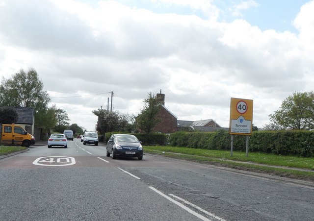
Sproston

Civil Parish in Cheshire

England

Sproston

The A54 heading towards Sproston and Middlewich beyond In Cheshire.
The A54 heading towards Sproston and Middlewich beyond Credit: James Denham

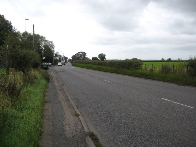
Sproston is a civil parish located in the county of Cheshire, England. It is situated approximately 3 miles south of the market town of Holmes Chapel and around 5 miles west of the town of Middlewich. The parish covers an area of about 1.5 square miles and is surrounded by a predominantly rural landscape.

The population of Sproston is relatively small, with an estimated 200 residents. The area is characterized by its picturesque countryside, with rolling hills, farmland, and scattered woodland. The village itself is made up of a collection of traditional Cheshire brick houses and cottages.

Within Sproston, there is a small church called St. Mary's, which dates back to the 12th century. The church is a Grade II listed building and is known for its beautiful stained glass windows and historic features.

The local economy is primarily agricultural, with farming being the main industry in the area. The land is used for livestock grazing and arable farming, with crops such as wheat and barley being grown. The parish is also home to a number of small businesses, including a few local shops and services.

Sproston is well-connected to surrounding areas via road networks, with the A50 passing through the northern part of the parish. This provides easy access to nearby towns and cities, such as Manchester and Stoke-on-Trent. The village also benefits from being in close proximity to the M6 motorway, making it easily accessible for commuters and visitors alike.

If you have any feedback on the listing, please let us know in the comments section below.

Sproston Images

Images are sourced within 2km of 53.190364/-2.400654 or Grid Reference SJ7365. Thanks to Geograph Open Source API. All images are credited.

The A54 heading towards Sproston and Middlewich beyond In Cheshire.
The A54 heading towards Sproston and Middlewich beyond
In Cheshire.
A54 Holmes Chapel Road at M6 junction 18 access roundabout Not as quiet a road/junction as the picture suggests, quite the reverse.
A54 Holmes Chapel Road at M6 junction 18 access roundabout
Not as quiet a road/junction as the picture suggests, quite the reverse.
Northbound access road M6 junction 18
A54 Holmes Chapel Road, Sproston Green
A54 at Holly Tree Farm, Sproston Green Looking west toward Middlewich.
A54 at Holly Tree Farm, Sproston Green
Looking west toward Middlewich.
Poolford Lane, Sproston Green Less a road more a farm track.
Poolford Lane, Sproston Green
Less a road more a farm track.
M6 exit slip at junction 18
Broad Lane crosses the M6
A54 Middlewich Way
A54 Middlewich Way
The M6 passes through farmland
The A54 at Holly Tree Farm
Fox & Hounds Public House
Approaching Middlewich on the A54
Sign Gantry at Junction 18, Southbound M6 The M6 motorway runs from junction 19 of the M1 at the Catthorpe Interchange, near Rugby to the Gretna junction (J45). Here it becomes the A74(M) and M74 which continues to Glasgow.

The M6 is the longest motorway in the United Kingdom (232 miles) and one of the busiest. It incorporates the first length of motorway opened in the UK (the Preston bypass in 1958) and forms part of a motorway "Backbone of Britain", running north-south between London and Glasgow via the industrial north of England. It is also part of the east-west route between the Midlands and the east coast ports.
Sign Gantry at Junction 18, Southbound M6
The M6 motorway runs from junction 19 of the M1 at the Catthorpe Interchange, near Rugby to the Gretna junction (J45). Here it becomes the A74(M) and M74 which continues to Glasgow. The M6 is the longest motorway in the United Kingdom (232 miles) and one of the busiest. It incorporates the first length of motorway opened in the UK (the Preston bypass in 1958) and forms part of a motorway "Backbone of Britain", running north-south between London and Glasgow via the industrial north of England. It is also part of the east-west route between the Midlands and the east coast ports.
Sign Gantry over Northbound M6 near Sproston Green The M6 motorway runs from junction 19 of the M1 at the Catthorpe Interchange, near Rugby to the Gretna junction (J45). Here it becomes the A74(M) and M74 which continues to Glasgow.

The M6 is the longest motorway in the United Kingdom (232 miles) and one of the busiest. It incorporates the first length of motorway opened in the UK (the Preston bypass in 1958) and forms part of a motorway "Backbone of Britain", running north-south between London and Glasgow via the industrial north of England. It is also part of the east-west route between the Midlands and the east coast ports.
Sign Gantry over Northbound M6 near Sproston Green
The M6 motorway runs from junction 19 of the M1 at the Catthorpe Interchange, near Rugby to the Gretna junction (J45). Here it becomes the A74(M) and M74 which continues to Glasgow. The M6 is the longest motorway in the United Kingdom (232 miles) and one of the busiest. It incorporates the first length of motorway opened in the UK (the Preston bypass in 1958) and forms part of a motorway "Backbone of Britain", running north-south between London and Glasgow via the industrial north of England. It is also part of the east-west route between the Midlands and the east coast ports.
Northbound M6, Sign Gantry at Junction 18 The M6 motorway runs from junction 19 of the M1 at the Catthorpe Interchange, near Rugby to the Gretna junction (J45). Here it becomes the A74(M) and M74 which continues to Glasgow.

The M6 is the longest motorway in the United Kingdom (232 miles) and one of the busiest. It incorporates the first length of motorway opened in the UK (the Preston bypass in 1958) and forms part of a motorway "Backbone of Britain", running north-south between London and Glasgow via the industrial north of England. It is also part of the east-west route between the Midlands and the east coast ports.
Northbound M6, Sign Gantry at Junction 18
The M6 motorway runs from junction 19 of the M1 at the Catthorpe Interchange, near Rugby to the Gretna junction (J45). Here it becomes the A74(M) and M74 which continues to Glasgow. The M6 is the longest motorway in the United Kingdom (232 miles) and one of the busiest. It incorporates the first length of motorway opened in the UK (the Preston bypass in 1958) and forms part of a motorway "Backbone of Britain", running north-south between London and Glasgow via the industrial north of England. It is also part of the east-west route between the Midlands and the east coast ports.
Mist on the Croco Early morning view of the River Croco.
Mist on the Croco
Early morning view of the River Croco.
Cows at Daisybank Farm
Show me another place!

Sproston is located at Grid Ref: SJ7365 (Lat: 53.190364, Lng: -2.400654)

Unitary Authority: Cheshire West and Chester

Police Authority: Cheshire

What 3 Words

///amended.revise.gazes. Near Middlewich, Cheshire

Nearby Locations

Sproston

Related Wikis

Sproston

Sproston is a village and civil parish in the unitary authority of Cheshire West and Chester and the ceremonial county of Cheshire, in the north-west of...

Cledford Bridge Halt railway station

Cledford Bridge Halt railway station was located in Middlewich, Cheshire, England. The station was opened by the London and North Western Railway on 2...

Holmes Chapel Comprehensive School

Holmes Chapel Comprehensive School is a co-educational secondary school and sixth form centre located in Holmes Chapel, Cheshire, England. It was founded...

Kinderton

Kinderton is an electoral ward in Middlewich, Cheshire, England. Kinderton was also historically the name of a township in Middlewich on the opposite...

Middlewich railway station

Middlewich railway station served the Cheshire, England, salt-producing town of Middlewich between 1868 and 1960. It lay on a branch line from Sandbach...

Wardle Canal

The Wardle Canal is the shortest canal in the UK, at 154 feet (47 m). The canal, in Middlewich, Cheshire, connects the Trent and Mersey Canal to the Middlewich...

Middlewich Urban District

Middlewich Urban District is a former Urban District in Cheshire, based in the town of Middlewich. It was created in 1894 and abolished in 1974 when it...

Middlewich

Middlewich is a town in the unitary authority of Cheshire East and the ceremonial county of Cheshire, England, 19.2 miles (30.9 km) east of Chester, 2...

Nearby Amenities

Located within 500m of 53.190364,-2.400654
The data included in this document is from www.openstreetmap.org. The data is made available under ODbL.

Have you been to Sproston?

Leave your review of Sproston below (or comments, questions and feedback).