Brushford

Settlement in Somerset Somerset West and Taunton

England

Brushford

Exebridge at Exebridge Seen from the beer garden of The Anchor Inn. The three arch stone bridge is thought to be 18th century (but with a bridge in this location since the 14th century) with major repairs in 1853 and 1929. The river is the boundary between Devon (right) and Somerset (left).
Exebridge at Exebridge Credit: Chris Allen

Brushford is a small village located in the county of Somerset, England. Situated in the heart of the Exmoor National Park, it lies approximately 7 miles west of the town of Dulverton and 12 miles north of the bustling market town of Tiverton. With a population of around 200 residents, Brushford is a peaceful and picturesque rural community.

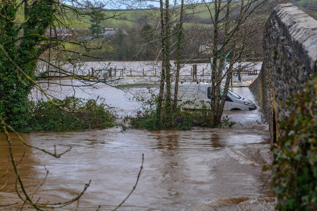
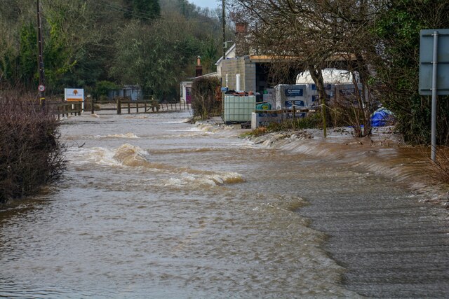
The village is surrounded by stunning natural beauty, characterized by rolling hills, lush green pastures, and dense woodlands. It is traversed by the River Barle, which adds to the tranquil ambiance and provides opportunities for fishing and other water-related activities.

Historically, Brushford was an important center for the area's agricultural industry, with farming playing a significant role in the local economy. Today, while agriculture remains a part of the village's identity, many residents are employed in other sectors such as tourism, hospitality, and small-scale businesses.

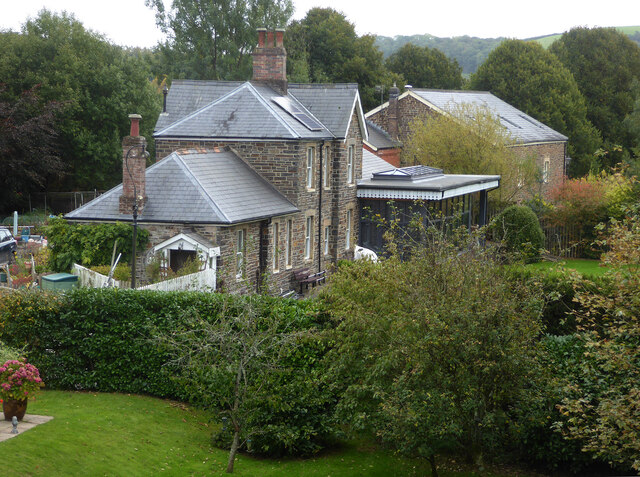
The village is home to a number of charming old buildings, including St. Nicholas Church, which dates back to the 12th century and showcases beautiful architecture. There are also several traditional thatched cottages and farmhouses, adding to the village's quaint and timeless atmosphere.

For outdoor enthusiasts, Brushford offers an abundance of opportunities for walking, hiking, and cycling, with numerous trails and paths winding through the surrounding countryside. The Exmoor National Park Visitor Center is located nearby, providing information on the local flora, fauna, and wildlife.

Overall, Brushford is a delightful rural village that attracts visitors seeking a peaceful retreat amidst picturesque landscapes and a rich historical heritage.

If you have any feedback on the listing, please let us know in the comments section below.

Brushford Images

Images are sourced within 2km of 51.020573/-3.535968 or Grid Reference SS9225. Thanks to Geograph Open Source API. All images are credited.

Exebridge at Exebridge Seen from the beer garden of The Anchor Inn. The three arch stone bridge is thought to be 18th century (but with a bridge in this location since the 14th century) with major repairs in 1853 and 1929. The river is the boundary between Devon (right) and Somerset (left).
Exebridge at Exebridge
Seen from the beer garden of The Anchor Inn. The three arch stone bridge is thought to be 18th century (but with a bridge in this location since the 14th century) with major repairs in 1853 and 1929. The river is the boundary between Devon (right) and Somerset (left).
The Anchor Inn, Exebridge By the River Exe and the eponymous bridge. The three arch masonry bridge is on the right. This was a quick stop on the way to Dulverton. I believe the pub is just in Devon as the river is the boundary with Somerset.
The Anchor Inn, Exebridge
By the River Exe and the eponymous bridge. The three arch masonry bridge is on the right. This was a quick stop on the way to Dulverton. I believe the pub is just in Devon as the river is the boundary with Somerset.
Former Dulverton Station Seen from a bridge over the dismantled railway line. The stationmaster's house and goods shed were built by the Devon and somerset Railway and opened in 1873. The Exe Valley Railway also had its terminus here. The station is actually about 2 miles south of Dulverton and in Brushford.
Former Dulverton Station
Seen from a bridge over the dismantled railway line. The stationmaster's house and goods shed were built by the Devon and somerset Railway and opened in 1873. The Exe Valley Railway also had its terminus here. The station is actually about 2 miles south of Dulverton and in Brushford.
Brushford : Exebridge - River Exe Looking across the River Exe which has flooded.
Brushford : Exebridge - River Exe
Looking across the River Exe which has flooded.
Brushford : Exebridge - River Exe Looking down the River Exe from Exe Bridge.
Brushford : Exebridge - River Exe
Looking down the River Exe from Exe Bridge.
Morebath - Exebridge - The Anchor Inn The Anchor Inn has flooded.
Morebath - Exebridge - The Anchor Inn
The Anchor Inn has flooded.
Morebath - Exebridge - River Exe Looking across the flooded River Exe.
Morebath - Exebridge - River Exe
Looking across the flooded River Exe.
Morebath : Exebridge - B3222 The road heads through Exebridge, passing the Anchor Inn.
Morebath : Exebridge - B3222
The road heads through Exebridge, passing the Anchor Inn.
Morebath : Exebridge - B3222 Looking along the flooded B3222 road.
Morebath : Exebridge - B3222
Looking along the flooded B3222 road.
Morebath - Exebridge - The Anchor Inn The Anchor Inn in Exebridge.
Morebath - Exebridge - The Anchor Inn
The Anchor Inn in Exebridge.
Morebath : Exebridge - B3222 It is impossible to pass through this stretch of road.
Morebath : Exebridge - B3222
It is impossible to pass through this stretch of road.
Morebath : Exebridge - B3222 Two cars are submerged in the water as the River Exe bursts its banks.
Morebath : Exebridge - B3222
Two cars are submerged in the water as the River Exe bursts its banks.
Morebath - Exebridge - The Anchor Inn The Anchor Inn with the River Exe floods taking its toll.
Morebath - Exebridge - The Anchor Inn
The Anchor Inn with the River Exe floods taking its toll.
Brushford : Exebridge - River Exe Looking across Exe Bridge and towards the car park which is situated by the bridge, and is today underwater.
Brushford : Exebridge - River Exe
Looking across Exe Bridge and towards the car park which is situated by the bridge, and is today underwater.
Morebath : Exebridge - B3222 Looking along the road which is under the water.
Morebath : Exebridge - B3222
Looking along the road which is under the water.
Morebath : Exebridge - B3222 Two people walk through the floodwaters of the River Exe.
Morebath : Exebridge - B3222
Two people walk through the floodwaters of the River Exe.
Morebath : Exebridge - B3222 The road is flooded.
Morebath : Exebridge - B3222
The road is flooded.
Morebath : Exebridge - B3222 The road has been closed due to the flooding.
Morebath : Exebridge - B3222
The road has been closed due to the flooding.
Show me another place!

Brushford is located at Grid Ref: SS9225 (Lat: 51.020573, Lng: -3.535968)

Administrative County: Somerset

District: Somerset West and Taunton

Police Authority: Avon and Somerset

What 3 Words

///goad.spurring.implore. Near Dulverton, Somerset

Related Wikis

Brushford, Somerset

Brushford is a village and civil parish 2 miles (3.2 km) south of Dulverton and 12 miles (19 km) north of Tiverton in Devon, in the Somerset West and Taunton...

River Barle

The River Barle runs from the Chains on northern Exmoor, in Somerset, England to join the River Exe at Exebridge, Devon. The river and the Barle Valley...

Combe, Dulverton

Combe is a historic estate in Somerset, England, situated between the town of Dulverton and the village of Brushford. == Descent == === Taunton Priory... ===

River Haddeo

The River Haddeo on Exmoor in Somerset, England flows from the Wimbleball Lake to the River Exe. The valley of the river consists of three tributary valleys...

Exebridge

Exebridge is a village that lies on the border between Devon and Somerset, England. It lies at the confluence of the Barle and Exe rivers. Exebridge is...

Bury Castle, Brompton Regis

Bury Castle near Brompton Regis in the English county of Somerset was an Iron Age univallate hillfort which was reused with the creation of a motte after...

Dulverton Town Hall

Dulverton Town Hall is a municipal building in Fore Street in Dulverton, Somerset, England. The building, which is the meeting place of Dulverton Town...

Barle Bridge

Barle Bridge is a five span stone arch bridge over the River Barle in Dulverton within the English county of Somerset, which is medieval in origin. It...

Nearby Amenities

Located within 500m of 51.020573,-3.535968
Brushford
Is In: Somerset, England, UK
Place: village
Wikidata: Q4979736
Wikipedia: en:Brushford, Somerset
Lat/Long: 51.0205558/-3.538389
Give Way
Direction: backward
Lat/Long: 51.0206326/-3.5350579
Direction: forward
Maxspeed: 30 mph
Maxspeed Type: GB:nsl_restricted
Source Maxspeed: sign
Traffic Sign: maxspeed
Lat/Long: 51.0236771/-3.5341787
Give Way
Direction: backward
Lat/Long: 51.0170429/-3.5316932
Give Way
Direction: forward
Lat/Long: 51.0208731/-3.5338908
Give Way
Direction: backward
Lat/Long: 51.0213445/-3.5331441
Travis Perkins
Brand: Travis Perkins
Brand Wikidata: Q2450664
Shop: doityourself
Website: https://www.travisperkins.co.uk/branch-locator/3033
Lat/Long: 51.0177032/-3.5320884
Post Box
Operator: Royal Mail
Operator Wikidata: Q638098
Post Box Type: lamp
Ref: TA22 54D
Royal Cypher: EIIR
Royal Cypher Wikidata: Q33102113
Lat/Long: 51.020833/-3.5333611
Community Centre
Parish Hall
Addr City: Dulverton
Addr Country: GB
Addr County: Somerset
Addr Postcode: TA22 9AH
Addr Street: Brushford New Road
Addr Village: Brushford
Fhrs Authority: West Somerset
Fhrs Id: 188328
Fhrs Local Authority Id: PI/000004698
Lat/Long: 51.0204433/-3.5374475
Three Acres Country House
Addr City: Dulverton
Addr Country: GB
Addr County: Somerset
Addr Postcode: TA22 9AR
Addr Street: Ellersdown Lane
Addr Village: Brushford
Fhrs Authority: West Somerset
Fhrs Id: 160507
Fhrs Local Authority Id: PI/000000198
Tourism: hotel
Lat/Long: 51.0219179/-3.5392124
Brushford Bizarre
Addr City: Dulverton
Addr Postcode: TA22 9BJ
Addr Street: Brushford New Road
Opening Hours: Fr-Su 10:00-16:00
Phone: +447802357962
Shop: variety_store
Lat/Long: 51.0207781/-3.5335273
Give Way
Direction: forward
Lat/Long: 51.0211249/-3.5394055
Give Way
Direction: forward
Lat/Long: 51.0213683/-3.5363632
Give Way
Direction: forward
Lat/Long: 51.0211654/-3.5361788
Give Way
Direction: backward
Lat/Long: 51.0207031/-3.535063
Give Way
Direction: backward
Lat/Long: 51.0209933/-3.5332149
Direction: forward
Maxspeed: 30 mph
Maxspeed Type: GB:nsl_restricted
Source Maxspeed: sign
Traffic Sign: maxspeed
Lat/Long: 51.0204956/-3.5391493
Give Way
Direction: backward
Lat/Long: 51.0206027/-3.5392673
Give Way
Direction: forward
Lat/Long: 51.0205471/-3.5391681
Direction: backward
Maxspeed: 30 mph
Maxspeed Type: GB:nsl_restricted
Source Maxspeed: sign
Traffic Sign: maxspeed
Lat/Long: 51.017121/-3.53167
Generator Method: photovoltaic
Generator Output Electricity: yes
Generator Source: solar
Generator Type: solar_photovoltaic_panel
Location: roof
Power: generator
Lat/Long: 51.0204455/-3.5363269
Generator Method: photovoltaic
Generator Output Electricity: yes
Generator Source: solar
Generator Type: solar_photovoltaic_panel
Location: roof
Power: generator
Lat/Long: 51.0206851/-3.5403046
Generator Method: photovoltaic
Generator Output Electricity: yes
Generator Source: solar
Generator Type: solar_photovoltaic_panel
Location: roof
Power: generator
Lat/Long: 51.0209095/-3.5408893
Generator Method: photovoltaic
Generator Output Electricity: yes
Generator Source: solar
Generator Type: solar_photovoltaic_panel
Location: roof
Power: generator
Lat/Long: 51.0211761/-3.5368472
Generator Method: photovoltaic
Generator Output Electricity: yes
Generator Source: solar
Generator Type: solar_photovoltaic_panel
Location: roof
Power: generator
Lat/Long: 51.0207947/-3.5358065
Generator Method: photovoltaic
Generator Output Electricity: yes
Generator Source: solar
Generator Type: solar_photovoltaic_panel
Location: roof
Power: generator
Lat/Long: 51.0199149/-3.533292
Generator Method: photovoltaic
Generator Output Electricity: yes
Generator Source: solar
Generator Type: solar_photovoltaic_panel
Location: roof
Power: generator
Lat/Long: 51.019957/-3.5332973
Generator Method: photovoltaic
Generator Output Electricity: yes
Generator Source: solar
Generator Type: solar_photovoltaic_panel
Location: roof
Power: generator
Lat/Long: 51.0205773/-3.5326181
Generator Method: photovoltaic
Generator Output Electricity: yes
Generator Source: solar
Generator Type: solar_photovoltaic_panel
Location: roof
Power: generator
Lat/Long: 51.0205638/-3.5326744
Generator Method: photovoltaic
Generator Output Electricity: yes
Generator Source: solar
Generator Type: solar_photovoltaic_panel
Location: roof
Power: generator
Lat/Long: 51.0228685/-3.5346968
Generator Method: photovoltaic
Generator Output Electricity: yes
Generator Source: solar
Generator Type: solar_photovoltaic_panel
Location: roof
Power: generator
Lat/Long: 51.0228517/-3.5348014
Power: pole
Source: bing
Lat/Long: 51.0221744/-3.5314044
Poles: bipole
Power: pole
Source: bing
Transformer: distribution
Lat/Long: 51.0217576/-3.5328233
Power: pole
Source: bing
Lat/Long: 51.0224004/-3.5304683
Power: pole
Source: bing
Lat/Long: 51.0217197/-3.5298514
Power: pole
Source: bing
Lat/Long: 51.0210077/-3.5292184
The data included in this document is from www.openstreetmap.org. The data is made available under ODbL.

Have you been to Brushford?

Leave your review of Brushford below (or comments, questions and feedback).