Ringstead

Civil Parish in Northamptonshire

England

Ringstead

A45 southbound
A45 southbound Credit: Alex McGregor

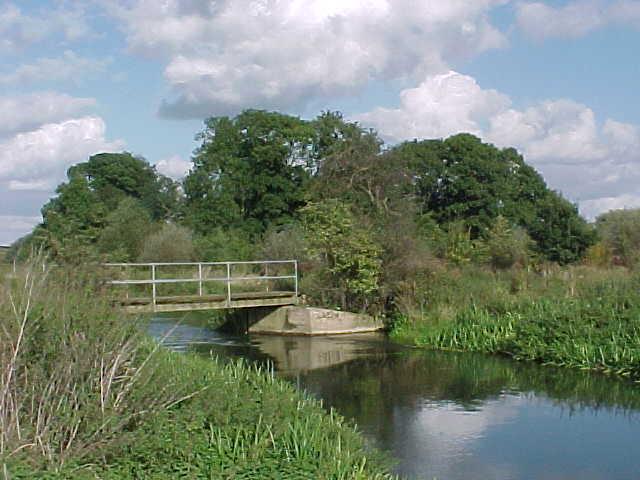
Ringstead is a civil parish located in the county of Northamptonshire, England. It is situated about 5 miles northeast of the town of Kettering and covers an area of approximately 1.5 square miles. The parish is surrounded by picturesque countryside, offering residents and visitors a tranquil and scenic environment.

The village of Ringstead itself is home to a population of around 1,000 people. It is known for its charming and traditional English village atmosphere, with many historic buildings and thatched cottages lining its streets. The centerpiece of the village is the 13th-century St Mary's Church, which stands as a testament to its rich history.

Ringstead boasts a range of amenities for its residents, including a primary school, a village hall, a local shop, and a pub. The village also has a strong sense of community, with various clubs and societies catering to different interests and hobbies.

Surrounded by rolling hills and verdant landscapes, Ringstead offers ample opportunities for outdoor activities. The nearby countryside is perfect for hiking, cycling, and exploring nature. The village is also conveniently located for those wishing to visit nearby attractions, such as Rockingham Castle and the historic town of Oundle.

In conclusion, Ringstead is a picturesque and thriving civil parish in Northamptonshire. With its historic charm, strong community spirit, and beautiful surroundings, it offers residents and visitors a delightful place to live or visit.

If you have any feedback on the listing, please let us know in the comments section below.

Ringstead Images

Images are sourced within 2km of 52.362689/-0.553831 or Grid Reference SP9874. Thanks to Geograph Open Source API. All images are credited.

A45 southbound
A45 southbound
The Nene Way crosses the River Nene
A45 southbound
A45 southbound
Meadow Lane at the junction of London Road
Parking area on the A45 west of Raunds
Trees by the A45, Raunds
London Road entering Raunds
The A45, Raunds
The A45, Raunds
Layby on the A45, Raunds
Denford, Holy Trinity
Layby on the A45, Raunds This was last year <a title="https://www.geograph.org.uk/photo/6212937" href="https://www.geograph.org.uk/photo/6212937">Link</a>
Layby on the A45, Raunds
This was last year Link
Roundabout on the A45, Raunds I suppose you could call this a Raundabout
Roundabout on the A45, Raunds
I suppose you could call this a Raundabout
A45 southbound
A45 southbound
A45 southbound
A45 southbound
A45 southbound
A45 southbound
A45 southbound
A45 southbound
The Nene Valley View east from a footpath
The Nene Valley
View east from a footpath
St Mary's Church Ringstead
Show me another place!

Ringstead is located at Grid Ref: SP9874 (Lat: 52.362689, Lng: -0.553831)

Unitary Authority: North Northamptonshire

Police Authority: Northamptonshire

What 3 Words

///term.pelted.cyber. Near Ringstead, Northamptonshire

Nearby Locations

Ringstead

Related Wikis

Ringstead, Northamptonshire

Ringstead is a village and civil parish in Northamptonshire, England, forming part of North Northamptonshire. It is located approximately 15 miles north...

Kinewell Lake

Kinewell Lake is a 35.4 hectare Local Nature Reserve west of Ringstead in Northamptonshire, England. It is owned by Ringstead Parish Council and managed...

Raunds Town F.C.

Raunds Town F.C. is a football club based at Raunds, Northamptonshire, England. The play in the Spartan South Midlands League Division One. They were FA...

Ringstead and Addington railway station

Ringstead and Addington railway station was a railway station serving Great and Little Addington and Ringstead in Northamptonshire on the former Northampton...

Denford

Denford is a small village and civil parish situated in North Northamptonshire, England. At the time of the 2001 census, the parish population was 250...

St Peter's Church, Raunds

St Peter's Church is an Anglican Church and the parish church of Raunds. It is a Grade I listed building and stands in an elevated position in Church Street...

Raunds

Raunds is a market town in North Northamptonshire, England. It had a population of 9,379 at the 2021 census. == Geography == Raunds is situated 21 miles...

Manor House, Raunds

The Manor House is a Grade II listed building that stands on a site at the northeast corner of the junction of Manor Street and High Street in Raunds,...

Nearby Amenities

Located within 500m of 52.362689,-0.553831
Ringstead
Place: village
Lat/Long: 52.365974/-0.5538696
Crossing
Crossing: uncontrolled
Crossing Ref: zebra
Lat/Long: 52.3655242/-0.5525078
Parking
Lat/Long: 52.3644207/-0.5587525
Dodson and Horrell Country Store
Addr City: Kettering
Addr Country: GB
Addr Housenumber: 2
Addr Postcode: NN14 4BX
Addr Street: Spencer Street
Addr Village: Ringstead
Shop: greengrocer
Lat/Long: 52.3650181/-0.5489894
Fast Food
Aroma Indian Cuisine
Addr City: Kettering
Addr Country: GB
Addr Housenumber: 24
Addr Postcode: NN14 4DH
Addr Street: Church Street
Addr Village: Ringstead
Cuisine: indian
Fhrs Authority: North Northamptonshire
Fhrs Id: 853401
Fhrs Local Authority Id: 16/00012/COM
Lat/Long: 52.3655759/-0.5530614
Power: pole
Lat/Long: 52.3632772/-0.5541286
Power: pole
Lat/Long: 52.3630065/-0.5556502
Power: pole
Lat/Long: 52.3625369/-0.5582699
Power: pole
Lat/Long: 52.3620488/-0.5609843
Power: pole
Lat/Long: 52.3627629/-0.5570146
Kindergarten
Ringstead Robins Pre School
Addr City: Kettering
Addr Country: GB
Addr Housenumber: 14
Addr Postcode: NN14 4DA
Addr Street: High Street
Addr Village: Ringstead
Lat/Long: 52.3659699/-0.5519074
Post Box
Brand: Royal Mail
Brand Wikidata: Q638098
Brand Wikipedia: en:Royal Mail
Operator: Royal Mail
Operator Wikidata: Q638098
Post Box Type: wall
Ref: NN14 60
Lat/Long: 52.3663252/-0.553445
Defibrillator
Emergency: defibrillator
Ref GB The Circuit: 27FCE2B8-E58B-4568-8321-F55971B71074
Lat/Long: 52.3658126/-0.5518912
Bench
Lat/Long: 52.3661321/-0.5522927
Bench
Lat/Long: 52.3661227/-0.5521776
Bench
Lat/Long: 52.3660529/-0.5521184
Bench
Lat/Long: 52.3660643/-0.5522477
Tourism: information
Lat/Long: 52.3661134/-0.5523212
Advertising: board
Lat/Long: 52.3660518/-0.5525031
Man Made: village_sign
Lat/Long: 52.3661036/-0.5523379
Bus Stop
Spencer Street (adj)
Naptan AtcoCode: 300000298N
Naptan CommonName: Spencer Street
Naptan Indicator: adj
Naptan Landmark: Spencer Street
Naptan NaptanCode: nthapwma
Naptan Street: Denford Road
Public Transport: platform
Lat/Long: 52.3652727/-0.5502194
Bus Stop
Spencer Street (opp)
Naptan AtcoCode: 300000298N1
Naptan CommonName: Spencer Street
Naptan Indicator: opp
Naptan Landmark: Spencer Street
Naptan NaptanCode: nthapwmd
Naptan Street: Denford Road
Public Transport: platform
Lat/Long: 52.3653998/-0.5502897
Bus Stop
Pound Close (adj)
Naptan AtcoCode: 300000298O
Naptan CommonName: Pound Close
Naptan Indicator: adj
Naptan Landmark: Pound Close
Naptan NaptanCode: nthamwpm
Naptan Street: Church Street
Public Transport: platform
Lat/Long: 52.3653619/-0.5516119
Bus Stop
Pound Close (opp)
Naptan AtcoCode: 300000298N2
Naptan CommonName: Pound Close
Naptan Indicator: opp
Naptan Landmark: Pound Close
Naptan NaptanCode: nthapwmg
Naptan Street: Church Street
Public Transport: platform
Lat/Long: 52.3654824/-0.551082
Bus Stop
Brook Walk (opp)
Naptan AtcoCode: 300000298CR
Naptan CommonName: Brook Walk
Naptan Indicator: opp
Naptan Landmark: Brook Walk
Naptan NaptanCode: nthapwjm
Naptan Street: Carlow Road
Public Transport: platform
Lat/Long: 52.3662303/-0.5568874
Defibrillator
Defibrillator Location: Next to window under sign
Emergency: defibrillator
Ref GB The Circuit: A278BDF7-FAB7-4792-AFDE-AFC400A4ADFB
Lat/Long: 52.3658498/-0.5572475
The data included in this document is from www.openstreetmap.org. The data is made available under ODbL.

Have you been to Ringstead?

Leave your review of Ringstead below (or comments, questions and feedback).