Rawdon

Civil Parish in Yorkshire Leeds

England

Rawdon

Sloping field beside Gill Lane
Sloping field beside Gill Lane Credit: David Martin

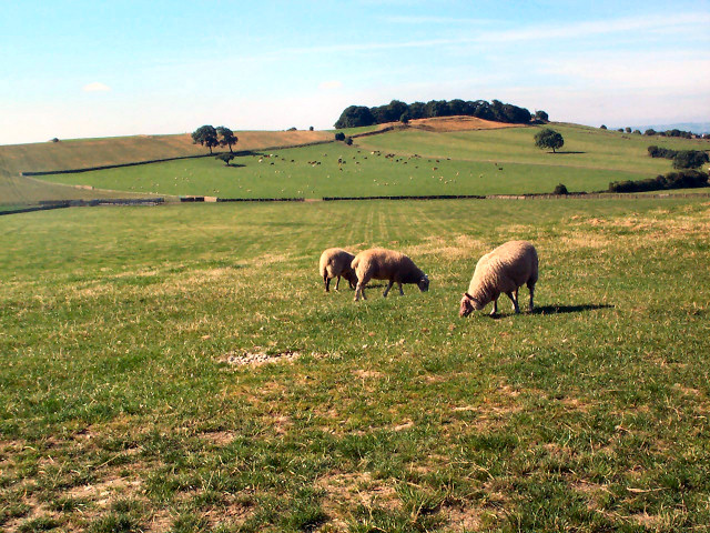
Rawdon is a civil parish located in the metropolitan borough of Leeds, West Yorkshire, England. It is situated approximately 8 miles northwest of Leeds city center and covers an area of around 6 square miles. The parish is known for its picturesque landscape, with rolling hills and open countryside.

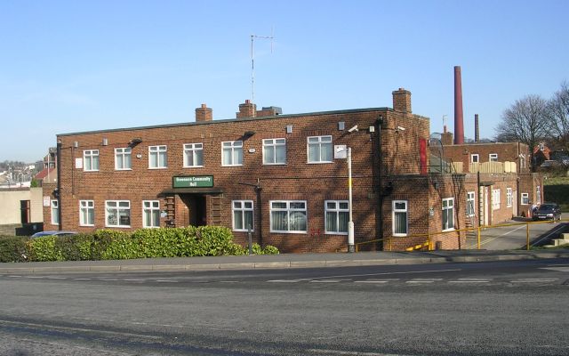
Rawdon has a population of around 8,000 people, according to the latest census data. It is a predominantly residential area, with a mix of housing types ranging from traditional stone-built cottages to modern developments. The village center features a range of amenities, including local shops, restaurants, and pubs, providing residents with all the necessary conveniences.

The area is rich in history, with several notable landmarks and historical sites. Rawdon Billing, a prominent hill located within the parish, offers stunning views of the surrounding countryside and is a popular spot for outdoor activities such as walking and birdwatching. There are also several old churches, including St. Peter's Church, which dates back to the 12th century.

Rawdon has good transport links, with easy access to major road networks such as the A65 and A658, connecting it to nearby towns and cities. Leeds Bradford Airport is also located nearby, making it convenient for those who need to travel further afield.

Overall, Rawdon is a charming and vibrant civil parish, offering a peaceful rural setting while still being within easy reach of urban amenities.

If you have any feedback on the listing, please let us know in the comments section below.

Rawdon Images

Images are sourced within 2km of 53.847591/-1.679063 or Grid Reference SE2139. Thanks to Geograph Open Source API. All images are credited.

Sloping field beside Gill Lane
Morning sunlight in Gill Lane
A65 through Yeadon One of the main roads into and out of Leeds.  Busy in rush hours - and also on Sundays when it's one of the main routes to Ilkley, Skipton and the Yorkshire Dales.
A65 through Yeadon
One of the main roads into and out of Leeds. Busy in rush hours - and also on Sundays when it's one of the main routes to Ilkley, Skipton and the Yorkshire Dales.
Field at Henshaw, Yeadon This part of lower Yeadon, that the A65 runs through, is known as Henshaw.  Here cows rest in the fields in front of the Westfield estate.
Field at Henshaw, Yeadon
This part of lower Yeadon, that the A65 runs through, is known as Henshaw. Here cows rest in the fields in front of the Westfield estate.
Sheep pastures behind The Billing The view southwest from Bayton Lane contrasts with the northeast side of the gridsquare (part of Leeds-Bradford Airport).
Sheep pastures behind The Billing
The view southwest from Bayton Lane contrasts with the northeast side of the gridsquare (part of Leeds-Bradford Airport).
Trig point at Plane Tree Hill The trig point has had a wall built up against it and is visible at the wall's left end. This area behind Leeds Bradford Airport is used for impromptu motorsport (despite police notices). The map calls this Plane Tree Hill; it has plenty of planes, but few trees.
Trig point at Plane Tree Hill
The trig point has had a wall built up against it and is visible at the wall's left end. This area behind Leeds Bradford Airport is used for impromptu motorsport (despite police notices). The map calls this Plane Tree Hill; it has plenty of planes, but few trees.
Canada Road, LS19 Just off Harrogate Road (the B6512) in Rawdon. Note the smoke-stained but well-pointed square blocks of Millstone Grit.
Canada Road, LS19
Just off Harrogate Road (the B6512) in Rawdon. Note the smoke-stained but well-pointed square blocks of Millstone Grit.
Christian Science Church, Quakers Lane, Rawdon At the junction of Quakers Lane and Park Road, looking south
Christian Science Church, Quakers Lane, Rawdon
At the junction of Quakers Lane and Park Road, looking south
Quaker Cottage, Quakers Lane, Rawdon Looking north across Quakers Lane. The cottage lies in front of the Friends Meeting House.
Quaker Cottage, Quakers Lane, Rawdon
Looking north across Quakers Lane. The cottage lies in front of the Friends Meeting House.
Friends Meeting House, Quakers Lane, Rawdon The Meeting House of The Society of Friends (Quakers), looking north from the gate on Quakers Lane.
Friends Meeting House, Quakers Lane, Rawdon
The Meeting House of The Society of Friends (Quakers), looking north from the gate on Quakers Lane.
Rawdon fire station Rawdon fire station, Green Lane, Yeadon, Leeds, West Yorkshire.
Rawdon fire station
Rawdon fire station, Green Lane, Yeadon, Leeds, West Yorkshire.
Wool Mill Chimney, Rawdon. Chimney on the last remaining woollen mill in Yorkshire, at Rawdon, near Yeadon, West Yorkshire.
Wool Mill Chimney, Rawdon.
Chimney on the last remaining woollen mill in Yorkshire, at Rawdon, near Yeadon, West Yorkshire.
Abandoned chairs on Yeadon Cricket Ground
Old buildings, Leeds Bradford Airport From Ryanair Boeing 737 as it taxis towards the east end of Runway 32
Old buildings, Leeds Bradford Airport
From Ryanair Boeing 737 as it taxis towards the east end of Runway 32
Snicket Leading from the main road into Yeadon village.
Snicket
Leading from the main road into Yeadon village.
Greenacre Community Hall - New Road Side
Trinity Church Hall - New Road Side
Trinity Church - New Road Side, Rawdon This is a joint Methodist, Baptist & United Reformed Church.
Trinity Church - New Road Side, Rawdon
This is a joint Methodist, Baptist & United Reformed Church.
Show me another place!

Rawdon is located at Grid Ref: SE2139 (Lat: 53.847591, Lng: -1.679063)

Division: West Riding

Administrative County: West Yorkshire

District: Leeds

Police Authority: West Yorkshire

What 3 Words

///settle.lobby.rare. Near Yeadon, West Yorkshire

Related Wikis

Rawdon, West Yorkshire

Rawdon is a village and civil parish in the metropolitan borough of the City of Leeds, West Yorkshire, England. It sits on the River Aire and on the A65...

Rawdon College

Rawdon Baptist College, or simply Rawdon College, was a Baptist institution in West Yorkshire that trained missionaries. == Location == Rawdon College...

Rawdon Billing

Rawdon Billing, sometimes referred to as Billing Hill, is a tree-topped hill situated in Rawdon, West Yorkshire, England. Reaching an elevation of 231...

Benton Park School

Benton Park School is a coeducational secondary school and sixth form located in Rawdon, West Yorkshire, England. Formerly a technology college, it has...

Little London, West Yorkshire

Little London is a village in West Yorkshire, England, that is divided between the Guiseley and Rawdon and the Horsforth wards of the City of Leeds and...

Horsforth Golf Club

Horsforth Golf Club is a golf club in the town of Horsforth in West Yorkshire, England. It is located next to Leeds Bradford Airport. It was established...

Yeadon railway station (England)

Yeadon railway station was a goods only railway station in West Yorkshire that operated between 1894 and 1964. A station for Yeadon was first proposed...

Woodhouse Grove School

Woodhouse Grove School ('The Grove') is a private, co-educational, day and boarding school and Sixth Form. it is located to the north of Apperley Bridge...

Nearby Amenities

Located within 500m of 53.847591,-1.679063
Mini Roundabout
Direction: clockwise
Lat/Long: 53.8504152/-1.6746029
Crossing
Crossing: unmarked
Crossing Island: no
Tactile Paving: yes
Lat/Long: 53.8504097/-1.6739456
Leeds Road Rawdon Drive
Bus: yes
Public Transport: stop_position
Lat/Long: 53.8506097/-1.6823393
Turning Circle
Lat/Long: 53.8499636/-1.67638
Turning Circle
Lat/Long: 53.8496074/-1.6757673
Turning Circle
Lat/Long: 53.8516093/-1.67994
Noexit: yes
Lat/Long: 53.8513244/-1.6788031
Leeds Road
Bus: yes
Public Transport: stop_position
Lat/Long: 53.8479992/-1.6724079
Barrier: stile
Material: metal
Stile: stepover
Lat/Long: 53.8441734/-1.6787502
Traffic Calming: hump
Lat/Long: 53.8443107/-1.6842263
Traffic Calming: bump
Lat/Long: 53.8436776/-1.6822309
Bus Stop
Over Lane Well Lane
Bus: yes
Local Ref: 45013146
Naptan AtcoCode: 450013146
Naptan Bearing: W
Naptan CommonName: Over Lane Well Lane
Naptan Crossing: Well Lane
Naptan Indicator: Stop 45013146
Naptan Landmark: Emmott Arms PH
Naptan PlusbusZoneRef: LEEDS
Naptan ShortCommonName: Well Lane
Naptan Street: Over Road
Naptan Verified: no
Public Transport: platform
Source: naptan_import
Lat/Long: 53.8503257/-1.6743758
Bus Stop
Leeds Road
Bus: yes
Local Ref: 45018801
Naptan AtcoCode: 450018801
Naptan Bearing: N
Naptan CommonName: Leeds Road
Naptan Crossing: Nr-Opp Henley Crescent
Naptan Indicator: Stop 45018801
Naptan Landmark: Carrs Farm Cottage - Adj Low Green Farm
Naptan PlusbusZoneRef: LEEDS
Naptan ShortCommonName: Henley Avenue
Naptan Street: Leeds Road
Naptan Verified: no
Public Transport: platform
Shelter: no
Source: naptan_import
Timetable: yes
Lat/Long: 53.8479476/-1.6724487
Bus Stop
Leeds Road
Bench: no
Bus: yes
Local Ref: 45018802
Naptan AtcoCode: 450018802
Naptan Bearing: SE
Naptan CommonName: Leeds Road
Naptan Crossing: Carr Lane
Naptan Indicator: Stop 45018802
Naptan PlusbusZoneRef: LEEDS
Naptan ShortCommonName: Henley Avenue
Naptan Street: Leeds Road
Naptan Verified: no
Public Transport: platform
Shelter: no
Source: naptan_import
Timetable: yes
Lat/Long: 53.8478378/-1.6717503
Bus Stop
Larkfield Road
Bus: yes
Local Ref: 45019776
Naptan AtcoCode: 450019776
Naptan Bearing: SE
Naptan CommonName: Larkfield Road
Naptan Crossing: Over Lane
Naptan Indicator: Stop 45019776
Naptan PlusbusZoneRef: LEEDS
Naptan ShortCommonName: Over Lane
Naptan Street: Larkfield Road
Naptan Verified: no
Public Transport: platform
Source: naptan_import
Lat/Long: 53.8506598/-1.6749509
Bus Stop
Leeds Road Rawdon Drive
Bus: yes
Local Ref: 45019796
Naptan AtcoCode: 450019796
Naptan Bearing: NW
Naptan CommonName: Leeds Road Rawdon Drive
Naptan Crossing: Rawdon Drive
Naptan Indicator: Stop 45019796
Naptan PlusbusZoneRef: LEEDS
Naptan ShortCommonName: Rawdon Drive
Naptan Street: Leeds Road
Naptan Verified: no
Public Transport: platform
Shelter: no
Source: naptan_import
Lat/Long: 53.8505629/-1.6823851
Bus Stop
Leeds Road
Bench: no
Bus: yes
Local Ref: 45019798
Naptan AtcoCode: 450019798
Naptan Bearing: SE
Naptan CommonName: Leeds Road
Naptan Crossing: Over lane
Naptan Indicator: Stop 45019798
Naptan PlusbusZoneRef: LEEDS
Naptan ShortCommonName: Leeds Road Over Ln
Naptan Street: Leeds Road
Naptan Verified: no
Public Transport: platform
Shelter: no
Source: naptan_import
Timetable: yes
Towards: Horsforth, Leeds
Lat/Long: 53.8499461/-1.6802768
Bus Stop
Leeds Road Well Lane
Bus: yes
Local Ref: 45019799
Naptan AtcoCode: 450019799
Naptan Bearing: W
Naptan CommonName: Leeds Road Well Lane
Naptan Crossing: Well Lane
Naptan Indicator: Stop 45019799
Naptan PlusbusZoneRef: LEEDS
Naptan ShortCommonName: Leeds Road Well Ln
Naptan Street: Leeds Road
Naptan Verified: no
Public Transport: platform
Shelter: no
Source: naptan_import
Timetable: yes
Lat/Long: 53.8490928/-1.677152
Bus Stop
Leeds Road Henley Drive
Bus: yes
Local Ref: 45019800
Naptan AtcoCode: 450019800
Naptan Bearing: E
Naptan CommonName: Leeds Road Henley Drive
Naptan Crossing: Henley Drive
Naptan Indicator: Stop 45019800
Naptan PlusbusZoneRef: LEEDS
Naptan ShortCommonName: Henley Drive
Naptan Street: Leeds Road
Naptan Verified: no
Public Transport: platform
Shelter: no
Source: naptan_import
Timetable: yes
Lat/Long: 53.8488819/-1.6755879
Bus Stop
Over Lane Prospect Street
Bus: yes
Naptan AtcoCode: 450028555
Naptan Bearing: W
Naptan CommonName: Over Lane Prospect Street
Naptan Crossing: Prospect Street
Naptan Landmark: Unknown
Naptan PlusbusZoneRef: LEEDS
Naptan ShortCommonName: Prospect Street
Naptan Street: Over Lane
Naptan Verified: no
Public Transport: platform
Source: naptan_import
Lat/Long: 53.8502551/-1.6782071
Bus Stop
Over Lane Prospect Street
Bus: yes
Naptan AtcoCode: 450028556
Naptan Bearing: E
Naptan CommonName: Over Lane Prospect Street
Naptan Crossing: Prospect Street
Naptan Landmark: Unknown
Naptan PlusbusZoneRef: LEEDS
Naptan ShortCommonName: Prospect Street
Naptan Street: Over Lane
Naptan Verified: no
Public Transport: platform
Source: naptan_import
Lat/Long: 53.8504254/-1.6780234
Turning Circle
Lat/Long: 53.8486677/-1.6720858
Post Box
Operator: Royal Mail
Post Box Type: wall
Ref: LS19 60
Lat/Long: 53.8487947/-1.6751843
Access: no
Barrier: stile
Foot: yes
Material: metal
Stile: stepover
Lat/Long: 53.8449589/-1.6806762
Parking
Parking: surface
Lat/Long: 53.8509138/-1.6821154
Post Box
Operator: Royal Mail
Post Box Type: lamp
Ref: LS19 94
Lat/Long: 53.8509164/-1.6823708
Noexit: yes
Lat/Long: 53.8514615/-1.6781555
Noexit: yes
Lat/Long: 53.8515207/-1.6783073
Turning Circle
Lat/Long: 53.8519512/-1.6781285
Noexit: yes
Lat/Long: 53.8519962/-1.6777254
Social Facility
Sunningdale Nursing Home
Addr City: Leeds
Addr Postcode: LS19 6PU
Addr Street: Town Street
Addr Suburb: Rawdon
Fhrs Id: 1061257
Social Facility: nursing_home
Lat/Long: 53.8501794/-1.6731513
Generator Method: photovoltaic
Generator Output Electricity: yes
Generator Source: solar
Generator Type: solar_photovoltaic_panel
Power: generator
Lat/Long: 53.8497865/-1.6727601
Fixme: Continues NW.
Lat/Long: 53.8447062/-1.6795406
Fixme: Continues NW.
Lat/Long: 53.8444215/-1.6794087
Parking
Parking: surface
Lat/Long: 53.8486703/-1.6757309
Give Way
Direction: forward
Lat/Long: 53.8489858/-1.6767019
Generator Method: photovoltaic
Generator Output Electricity: yes
Generator Source: solar
Generator Type: solar_photovoltaic_panel
Power: generator
Lat/Long: 53.8498082/-1.6763852
Information: guidepost
Tourism: information
Lat/Long: 53.8460889/-1.6847986
Direction: both
Traffic Calming: cushion
Lat/Long: 53.8503971/-1.6790605
Leeds Road
Bus: yes
Public Transport: stop_position
Lat/Long: 53.8499026/-1.6803072
Leeds Road Well Lane
Bus: yes
Public Transport: stop_position
Lat/Long: 53.8491361/-1.6771398
Leeds Road Henley Drive
Bus: yes
Public Transport: stop_position
Lat/Long: 53.848832/-1.6756104
Leeds Road
Bus: yes
Public Transport: stop_position
Lat/Long: 53.8477883/-1.6717988
Access: no
Barrier: stile
Foot: yes
Material: wood
Stile: squeezer
Lat/Long: 53.8452686/-1.6804724
Speed Camera
Maxspeed: 30 mph
Lat/Long: 53.8503896/-1.6816802
The data included in this document is from www.openstreetmap.org. The data is made available under ODbL.

Have you been to Rawdon?

Leave your review of Rawdon below (or comments, questions and feedback).