Ravenshead

Civil Parish in Nottinghamshire Gedling

England

Ravenshead

Scene at Brackenwood Home of Nottingham Sun Club.
Scene at Brackenwood Credit: David Lally

Ravenshead is a civil parish located in Nottinghamshire, England. It is situated approximately 5 miles north of Mansfield and 15 miles north of Nottingham. The area covers around 10 square kilometers and is known for its picturesque countryside and charming village atmosphere.

The village of Ravenshead is home to a population of around 6,500 residents. It has a rich history, with evidence of human habitation dating back to the Roman times. The name Ravenshead is believed to have derived from the Old English words "hræfn" and "heafod," meaning "raven" and "hill" respectively, indicating its geographical features.

Ravenshead offers a range of amenities and facilities to its residents and visitors. The village center is a vibrant hub with various shops, cafes, and restaurants. There are also several pubs and a community center that hosts various events and activities throughout the year.

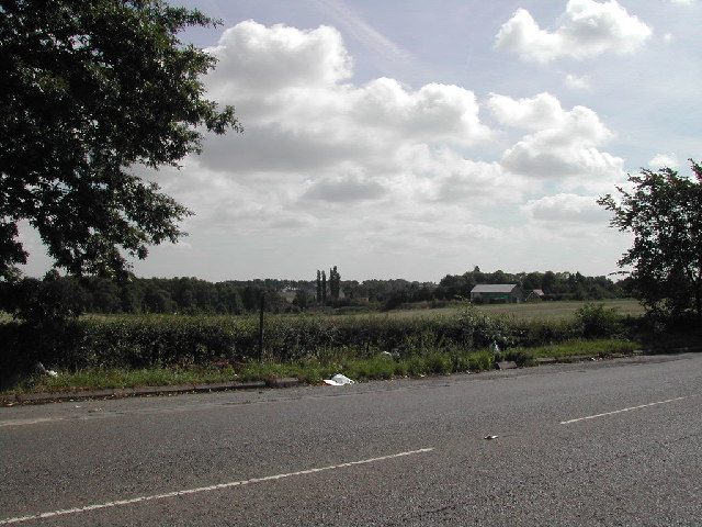
The surrounding countryside of Ravenshead provides ample opportunities for outdoor activities. The area is blessed with beautiful woodlands, such as Newstead Abbey and Sherwood Forest, which is famous for its association with the legendary outlaw Robin Hood. These natural landscapes are ideal for walking, cycling, and wildlife spotting.

Ravenshead is well-connected to nearby towns and cities through road networks, making it easily accessible for commuters. It also benefits from good public transport links, with regular bus services connecting the village to Mansfield and Nottingham.

Overall, Ravenshead offers a peaceful and picturesque setting with a strong sense of community, making it an attractive place to live or visit in Nottinghamshire.

If you have any feedback on the listing, please let us know in the comments section below.

Ravenshead Images

Images are sourced within 2km of 53.083363/-1.158101 or Grid Reference SK5654. Thanks to Geograph Open Source API. All images are credited.

Scene at Brackenwood Home of Nottingham Sun Club.
Scene at Brackenwood
Home of Nottingham Sun Club.
A small chalet at Brackenwood The grounds of Nottingham Sun Club.
A small chalet at Brackenwood
The grounds of Nottingham Sun Club.
A drooping footpath sign Beside the A60 just south of Ravenshead.
A drooping footpath sign
Beside the A60 just south of Ravenshead.
Dryad's saddle fungus The largest capped mushroom in the UK. Also known as pheasant's back mushroom, for an obvious reason
Dryad's saddle fungus
The largest capped mushroom in the UK. Also known as pheasant's back mushroom, for an obvious reason
Fishpool Road leaving Blidworth
The entrance to Fairview Farm Stud, Blidworth
Track to Bottom Farm, Blidworth The date 1983 is etched into the surface.
Track to Bottom Farm, Blidworth
The date 1983 is etched into the surface.
Calverton Road at the entrance to Bottom Farm
Morning sun through an oak tree On the grounds of Nottingham Sun Club.
Morning sun through an oak tree
On the grounds of Nottingham Sun Club.
Swinton Rise Ravenshead Primary School on the right.
Swinton Rise
Ravenshead Primary School on the right.
The Little John Inn
The Little John Inn
The sign of The Little John Inn See <a href="https://www.geograph.org.uk/photo/7584171">SK5655 : The Little John Inn</a>
The sign of The Little John Inn
Route 6 meets Ricket Lane The route doesn't actually join the lane here (though I did). It goes along the dirt path to the right to be "traffic free" for a few metres.
Route 6 meets Ricket Lane
The route doesn't actually join the lane here (though I did). It goes along the dirt path to the right to be "traffic free" for a few metres.
Little Ricket Lane
Little Ricket Lane
Blidworth Waye ( B683 ) between Papplewick and Ravenshead
Blidworth Waye ( B683 )
between Papplewick and Ravenshead
A60 at Trumper's Park, Ravenshead
Grays Lane, Ravenshead At the junction of the Mansfield Road (A60)
Grays Lane, Ravenshead
At the junction of the Mansfield Road (A60)
Blidworth Waye at the junction of the A60, Ravenshead
Blidworth Waye
at the junction of the A60, Ravenshead
Show me another place!

Ravenshead is located at Grid Ref: SK5654 (Lat: 53.083363, Lng: -1.158101)

Administrative County: Nottinghamshire

District: Gedling

Police Authority: Nottinghamshire

What 3 Words

///deliver.longingly.storage. Near Ravenshead, Nottinghamshire

Nearby Locations

Ravenshead

Related Wikis

Ravenshead

Ravenshead is a large village and civil parish in the Gedling district of Nottinghamshire, England. It borders Papplewick, Newstead Abbey and Blidworth...
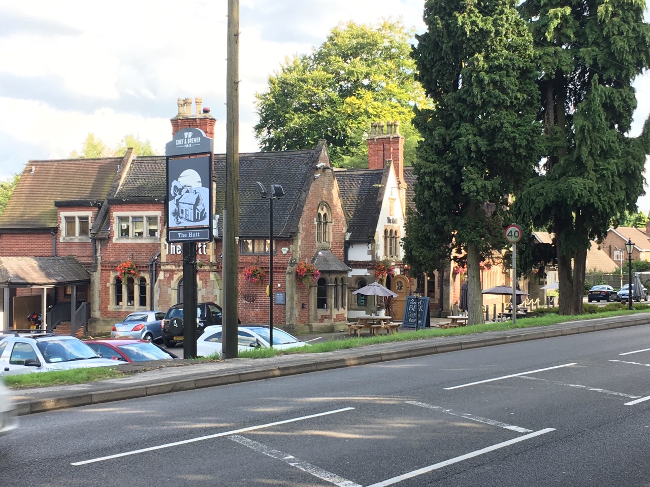
The Hutt

The Hutt is a public house located in the village of Ravenshead in Nottinghamshire, opposite Newstead Abbey. The pub was built on the site of The Royal...

Skegby Rural District

Skegby was a rural district in Nottinghamshire, England from 1894 to 1935. It was created under the Local Government Act 1894 based on that part of the...

Newstead Abbey

Newstead Abbey, in Nottinghamshire, England, was formerly an Augustinian priory. Converted to a domestic home following the Dissolution of the Monasteries...

Sherwood (UK Parliament constituency)

Sherwood is a constituency represented in the House of Commons of the UK Parliament since 2010 by Mark Spencer, a Conservative. The constituency takes...

Church of St Mary of the Purification, Blidworth

The Church of St Mary of the Purification is a parish church in the Church of England in Blidworth, Nottinghamshire, dating from the 15th century. It is...

Blidworth Bottoms

Blidworth Bottoms is a hamlet in Nottinghamshire, England. It is located between Blidworth and Ravenshead. Population details are included in the civil...

Portland College

Portland College is an education establishment near Ravenshead, Nottinghamshire, England. It is situated in 20 acres (81,000 m2) of Sherwood Forest approximately...

Nearby Amenities

Located within 500m of 53.083363,-1.158101
Turning Circle
Lat/Long: 53.0863256/-1.1579534
Ravenshead
Place: village
Wikidata: Q7296532
Wikipedia: en:Ravenshead
Lat/Long: 53.0868821/-1.1611984
Turning Circle
Lat/Long: 53.0806608/-1.1600585
Turning Circle
Lat/Long: 53.0866026/-1.1604446
Turning Circle
Lat/Long: 53.0849518/-1.1589955
Turning Circle
Lat/Long: 53.0838474/-1.1615766
Turning Circle
Lat/Long: 53.0808373/-1.1620406
Turning Circle
Lat/Long: 53.0816868/-1.1557412
Post Box
Created By: Potlatch 0.10f
Lat/Long: 53.0865105/-1.1565815
Post Box
Lat/Long: 53.0829797/-1.1620859
Bus Stop
Vernon Crescent
Bus: yes
Naptan AtcoCode: 3300GE0024
Naptan Bearing: SE
Naptan CommonName: Vernon Crescent
Naptan Indicator: o/s 33
Naptan NaptanCode: ntsawdwd
Naptan Notes: none
Naptan PlusbusZoneRef: MFLDTWN
Naptan Street: Vernon Crescent
Naptan Verified: no
Public Transport: platform
Source: naptan_import
Lat/Long: 53.0834333/-1.1642624
Bus Stop
Vernon Crescent
Bus: yes
Naptan AtcoCode: 3300GE0033
Naptan Bearing: NW
Naptan CommonName: Vernon Crescent
Naptan Indicator: o/s 22
Naptan NaptanCode: ntsdmgdj
Naptan Notes: none
Naptan PlusbusZoneRef: MFLDTWN
Naptan Street: Vernon Crescent
Naptan Verified: no
Public Transport: platform
Source: naptan_import
Lat/Long: 53.083446/-1.1647847
Bus Stop
Cheriton Drive
Bus: yes
Naptan AtcoCode: 3300GE0087
Naptan Bearing: W
Naptan CommonName: Cheriton Drive
Naptan Crossing: Cheriton Drive
Naptan Indicator: opp
Naptan Landmark: Sherwood Ranger
Naptan NaptanCode: ntsatgjp
Naptan Notes: none
Naptan PlusbusZoneRef: MFLDTWN
Naptan Street: Church Drive
Naptan Verified: no
Public Transport: platform
Source: naptan_import
Lat/Long: 53.0865211/-1.1559606
Bus Stop
Longdale Lane
Bus: yes
Naptan AtcoCode: 3300GE0099
Naptan Bearing: SE
Naptan CommonName: Longdale Lane
Naptan Indicator: o/s 79
Naptan NaptanCode: ntsaptwa
Naptan Notes: BW
Naptan PlusbusZoneRef: MFLDTWN
Naptan Street: Longdale Lane
Naptan Verified: no
Public Transport: platform
Source: naptan_import
Lat/Long: 53.0798499/-1.1621821
Bus Stop
Cheriton Drive
Bus: yes
Naptan AtcoCode: 3300GE0130
Naptan Bearing: E
Naptan CommonName: Cheriton Drive
Naptan Crossing: Cheriton Drive
Naptan Indicator: adj
Naptan Landmark: Sherwood Ranger
Naptan NaptanCode: ntsawpga
Naptan Notes: none
Naptan PlusbusZoneRef: MFLDTWN
Naptan Street: Church Drive
Naptan Verified: no
Public Transport: platform
Source: naptan_import
Lat/Long: 53.08658/-1.1553921
Bus Stop
Birchwood Drive
Bus: yes
Naptan AtcoCode: 3300GE0508
Naptan Bearing: E
Naptan CommonName: Birchwood Drive
Naptan Crossing: Birchwood Drive
Naptan Indicator: adj
Naptan NaptanCode: ntsatwjm
Naptan Notes: BW--3300GE0754
Naptan PlusbusZoneRef: MFLDTWN
Naptan Street: Vernon Crescent
Naptan Verified: no
Public Transport: platform
Source: naptan_import
Lat/Long: 53.083328/-1.1582477
Bus Stop
Health Centre
Bus: yes
Naptan AtcoCode: 3300GE0706
Naptan Bearing: N
Naptan BusStopType: CUS
Naptan CommonName: Health Centre
Naptan Crossing: Oakwood Drive
Naptan Indicator: opp
Naptan Landmark: Health Centre
Naptan NaptanCode: ntsapwtg
Naptan Notes: CUS
Naptan PlusbusZoneRef: MFLDTWN
Naptan Street: Longdale Avenue
Naptan Verified: no
Public Transport: platform
Source: naptan_import
Lat/Long: 53.0826386/-1.1624564
Bus Stop
Health Centre
Bus: yes
Naptan AtcoCode: 3300GE0707
Naptan Bearing: S
Naptan BusStopType: CUS
Naptan CommonName: Health Centre
Naptan Crossing: Oakwood Drive
Naptan Indicator: adj
Naptan Landmark: Health Centre
Naptan NaptanCode: ntsapwtj
Naptan Notes: CUS
Naptan PlusbusZoneRef: MFLDTWN
Naptan Street: Longdale Avenue
Naptan Verified: no
Public Transport: platform
Source: naptan_import
Lat/Long: 53.0826289/-1.162367
Priory Avenue
Naptan AtcoCode: 3300GE0711
Naptan Bearing: W
Naptan BusStopType: CUS
Naptan CommonName: Priory Avenue
Naptan Crossing: Priory Avenue
Naptan Indicator: adj
Naptan NaptanCode: ntsatada
Naptan Notes: CUS
Naptan PlusbusZoneRef: MFLDTWN
Naptan Street: Vernon Crescent
Naptan Verified: no
Source: naptan_import
Lat/Long: 53.0831118/-1.1569082
Bus Stop
Longdale Lane
Bus: yes
Naptan AtcoCode: 3300GE0725
Naptan Bearing: NW
Naptan BusStopType: CUS
Naptan CommonName: Longdale Lane
Naptan Indicator: opp 77
Naptan NaptanCode: ntsgjdwd
Naptan Notes: CUS--3300GE0099
Naptan PlusbusZoneRef: MFLDTWN
Naptan Street: Longdale Lane
Naptan Verified: no
Public Transport: platform
Source: naptan_import
Lat/Long: 53.0798516/-1.1624358
Birchwood Drive
Naptan AtcoCode: 3300GE0754
Naptan Bearing: W
Naptan BusStopType: CUS
Naptan CommonName: Birchwood Drive
Naptan Crossing: Birchwood Drive
Naptan Indicator: opp
Naptan NaptanCode: ntsgmjam
Naptan Notes: CUS--3300GE0508
Naptan PlusbusZoneRef: MFLDTWN
Naptan Street: Vernon Crescent
Naptan Verified: no
Source: naptan_import
Lat/Long: 53.0832574/-1.1584282
Turning Circle
Lat/Long: 53.0826677/-1.1642025
Turning Circle
Lat/Long: 53.0828352/-1.1649535
Turning Circle
Lat/Long: 53.0800537/-1.1603063
Turning Circle
Lat/Long: 53.084831/-1.1579833
Generator Method: photovoltaic
Generator Output Electricity: yes
Generator Source: solar
Generator Type: solar_photovoltaic_panel
Location: roof
Power: generator
Lat/Long: 53.0849582/-1.1560754
Turning Circle
Lat/Long: 53.0806923/-1.1587448
Generator Method: photovoltaic
Generator Output Electricity: yes
Generator Source: solar
Generator Type: solar_photovoltaic_panel
Location: roof
Power: generator
Lat/Long: 53.0859076/-1.1640483
Generator Method: photovoltaic
Generator Output Electricity: yes
Generator Source: solar
Generator Type: solar_photovoltaic_panel
Location: roof
Power: generator
Lat/Long: 53.0859398/-1.1634448
Generator Method: photovoltaic
Generator Output Electricity: yes
Generator Source: solar
Generator Type: solar_photovoltaic_panel
Location: roof
Power: generator
Lat/Long: 53.0850376/-1.1634716
Generator Method: photovoltaic
Generator Output Electricity: yes
Generator Source: solar
Generator Type: solar_photovoltaic_panel
Location: roof
Power: generator
Lat/Long: 53.0835684/-1.1643782
Generator Method: photovoltaic
Generator Output Electricity: yes
Generator Source: solar
Generator Type: solar_photovoltaic_panel
Location: roof
Power: generator
Lat/Long: 53.083607/-1.1642387
Generator Method: photovoltaic
Generator Output Electricity: yes
Generator Source: solar
Generator Type: solar_photovoltaic_panel
Location: roof
Power: generator
Lat/Long: 53.0856316/-1.1614492
Generator Method: photovoltaic
Generator Output Electricity: yes
Generator Source: solar
Generator Type: solar_photovoltaic_panel
Location: roof
Power: generator
Lat/Long: 53.0869864/-1.1591452
Generator Method: photovoltaic
Generator Output Electricity: yes
Generator Source: solar
Generator Type: solar_photovoltaic_panel
Location: roof
Power: generator
Lat/Long: 53.0863121/-1.1561666
Generator Method: photovoltaic
Generator Output Electricity: yes
Generator Source: solar
Generator Type: solar_photovoltaic_panel
Location: roof
Power: generator
Lat/Long: 53.086304/-1.156231
Generator Method: photovoltaic
Generator Output Electricity: yes
Generator Source: solar
Generator Type: solar_photovoltaic_panel
Location: roof
Power: generator
Lat/Long: 53.0858449/-1.1560888
Generator Method: photovoltaic
Generator Output Electricity: yes
Generator Source: solar
Generator Type: solar_photovoltaic_panel
Location: roof
Power: generator
Lat/Long: 53.0792362/-1.1579395
Generator Method: photovoltaic
Generator Output Electricity: yes
Generator Source: solar
Generator Type: solar_photovoltaic_panel
Location: roof
Power: generator
Lat/Long: 53.0798823/-1.1572261
Generator Method: photovoltaic
Generator Output Electricity: yes
Generator Source: solar
Generator Type: solar_photovoltaic_panel
Location: roof
Power: generator
Lat/Long: 53.0801529/-1.1572717
Generator Method: photovoltaic
Generator Output Electricity: yes
Generator Source: solar
Generator Type: solar_photovoltaic_panel
Location: roof
Power: generator
Lat/Long: 53.0799193/-1.160147
Generator Method: photovoltaic
Generator Output Electricity: yes
Generator Source: solar
Generator Type: solar_photovoltaic_panel
Location: roof
Power: generator
Lat/Long: 53.0799854/-1.1600102
Generator Method: photovoltaic
Generator Output Electricity: yes
Generator Source: solar
Generator Type: solar_photovoltaic_panel
Location: roof
Power: generator
Lat/Long: 53.0824005/-1.1569927
Generator Method: photovoltaic
Generator Output Electricity: yes
Generator Source: solar
Generator Type: solar_photovoltaic_panel
Location: roof
Power: generator
Lat/Long: 53.0831545/-1.1586744
Generator Method: photovoltaic
Generator Output Electricity: yes
Generator Source: solar
Generator Type: solar_photovoltaic_panel
Location: roof
Power: generator
Lat/Long: 53.0830981/-1.1582372
Generator Method: photovoltaic
Generator Output Electricity: yes
Generator Source: solar
Generator Type: solar_photovoltaic_panel
Location: roof
Power: generator
Lat/Long: 53.0830014/-1.1570973
Generator Method: photovoltaic
Generator Output Electricity: yes
Generator Source: solar
Generator Type: solar_photovoltaic_panel
Location: roof
Power: generator
Lat/Long: 53.0829676/-1.1633764
Generator Method: photovoltaic
Generator Output Electricity: yes
Generator Source: solar
Generator Type: solar_photovoltaic_panel
Location: roof
Power: generator
Lat/Long: 53.0828484/-1.1618931
Generator Method: photovoltaic
Generator Output Electricity: yes
Generator Source: solar
Generator Type: solar_photovoltaic_panel
Location: roof
Power: generator
Lat/Long: 53.082879/-1.1626468
Generator Method: photovoltaic
Generator Output Electricity: yes
Generator Source: solar
Generator Type: solar_photovoltaic_panel
Location: roof
Power: generator
Lat/Long: 53.0821411/-1.1613996
Restaurant
Ve Raj
Cuisine: indian
Delivery: yes
Opening Hours: Mo-Su 17:00-22:00
Phone: +44 1623 797024
Takeaway: yes
Website: https://www.verajrestaurant.com/
Lat/Long: 53.0862998/-1.1554715
Pub
The Sherwood Ranger
Beer Garden: yes
Opening Hours: Mo-Su 10:00-23:00
Outdoor Seating: yes
Phone: +44 1623 793040
Website: https://sherwoodrangerpub.com/
Lat/Long: 53.0862305/-1.1554494
Turning Circle
Lat/Long: 53.0863155/-1.1612409
Generator Method: photovoltaic
Generator Output Electricity: yes
Generator Source: solar
Generator Type: solar_photovoltaic_panel
Location: roof
Power: generator
Lat/Long: 53.0869989/-1.1593574
Generator Method: photovoltaic
Generator Output Electricity: yes
Generator Source: solar
Generator Type: solar_photovoltaic_panel
Location: roof
Power: generator
Lat/Long: 53.0851451/-1.1591421
Generator Method: photovoltaic
Generator Output Electricity: yes
Generator Source: solar
Generator Type: solar_photovoltaic_panel
Location: roof
Power: generator
Lat/Long: 53.084603/-1.1580706
Generator Method: photovoltaic
Generator Output Electricity: yes
Generator Source: solar
Generator Type: solar_photovoltaic_panel
Location: roof
Power: generator
Lat/Long: 53.0861004/-1.1580947
Generator Method: photovoltaic
Generator Output Electricity: yes
Generator Source: solar
Generator Type: solar_photovoltaic_panel
Location: roof
Power: generator
Lat/Long: 53.0861214/-1.1582597
Generator Method: photovoltaic
Generator Output Electricity: yes
Generator Source: solar
Generator Type: solar_photovoltaic_panel
Location: roof
Power: generator
Lat/Long: 53.0805563/-1.1595136
Generator Method: photovoltaic
Generator Output Electricity: yes
Generator Source: solar
Generator Type: solar_photovoltaic_panel
Location: roof
Power: generator
Lat/Long: 53.0842566/-1.160504
Generator Method: photovoltaic
Generator Output Electricity: yes
Generator Source: solar
Generator Type: solar_photovoltaic_panel
Location: roof
Power: generator
Lat/Long: 53.0853094/-1.1559235
Generator Method: photovoltaic
Generator Output Electricity: yes
Generator Source: solar
Generator Type: solar_photovoltaic_panel
Location: roof
Power: generator
Lat/Long: 53.0819971/-1.1652113
Waste Basket
Waste: dog_excrement
Lat/Long: 53.0859635/-1.1608641
Barrier: cycle_barrier
Cycle Barrier: double
Lat/Long: 53.0873577/-1.1609465
Barrier: cycle_barrier
Cycle Barrier: double
Lat/Long: 53.0874862/-1.1609347
Generator Method: photovoltaic
Generator Output Electricity: yes
Generator Source: solar
Generator Type: solar_photovoltaic_panel
Location: roof
Power: generator
Lat/Long: 53.0855583/-1.1625029
The data included in this document is from www.openstreetmap.org. The data is made available under ODbL.

Have you been to Ravenshead?

Leave your review of Ravenshead below (or comments, questions and feedback).