Pilning and Severn Beach

Civil Parish in Gloucestershire

England

Pilning and Severn Beach

Pilning (Glos) St Peter's Church
Pilning (Glos) St Peter's Church Credit: ChurchCrawler

Pilning and Severn Beach is a civil parish located in Gloucestershire, England. Situated on the eastern bank of the River Severn, it is approximately 10 miles northwest of Bristol city center. The parish is predominantly rural, with a small population of around 1,300 residents.

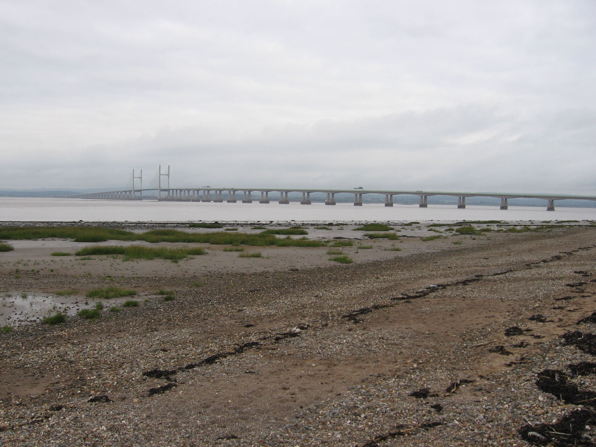
Pilning and Severn Beach is known for its picturesque landscapes and stunning views of the Severn Estuary. The area is rich in natural beauty, with expansive fields, meadows, and woodland areas. The River Severn, one of the longest rivers in the United Kingdom, flows alongside the parish, providing opportunities for recreational activities such as boating and fishing.

Severn Beach, the larger of the two settlements in the parish, is a popular destination for tourists and locals alike. It features a beautiful sandy beach, which stretches for approximately two miles along the estuary. The beach offers a tranquil setting for leisurely walks and picnics, as well as opportunities for birdwatching, as it is a designated Site of Special Scientific Interest.

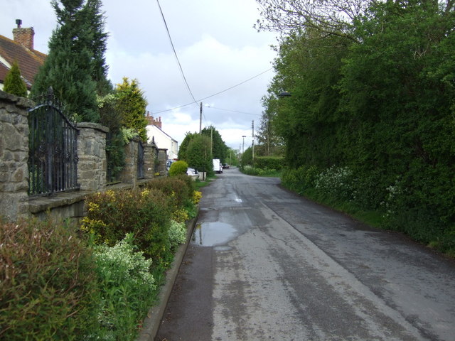
Pilning, on the other hand, is a smaller village located inland from Severn Beach. It boasts a traditional rural charm, with a mix of old and new buildings. The village is home to a few local amenities, including a primary school, a church, and a community center.

Overall, Pilning and Severn Beach is a peaceful and picturesque civil parish, offering a combination of natural beauty, recreational activities, and a sense of community.

If you have any feedback on the listing, please let us know in the comments section below.

Pilning and Severn Beach Images

Images are sourced within 2km of 51.564475/-2.661081 or Grid Reference ST5485. Thanks to Geograph Open Source API. All images are credited.

Pilning (Glos) St Peter's Church
Severn Beach and the Second Severn Crossing The river Severn at low tide looking out towards the Second Severn Crossing which is now 10 years old (opened 5th June 1996 by The Prince of Wales). The nearest channel of water is known as Salmon Pool.
Severn Beach and the Second Severn Crossing
The river Severn at low tide looking out towards the Second Severn Crossing which is now 10 years old (opened 5th June 1996 by The Prince of Wales). The nearest channel of water is known as Salmon Pool.
Severn Beach Looking South Looking along the edge of the estuary and salt marshes whilst standing on the sea defences at Severn Beach.
Severn Beach Looking South
Looking along the edge of the estuary and salt marshes whilst standing on the sea defences at Severn Beach.
River Severn at low tide Looking across the river bed at low tide. On the horizon Denny Island can be seen faintly.
River Severn at low tide
Looking across the river bed at low tide. On the horizon Denny Island can be seen faintly.
Severn Beach railway platform Severn Beach is now the last (or first!) stop on the line which goes from Bristol Temple Meads through Montpelier and Clifton, along the north bank of the Avon into Shirehampton, then through Avonmouth and along the banks of the River Severn until it reaches its destination. It consists of a platform and shelter, and little else.
Severn Beach railway platform
Severn Beach is now the last (or first!) stop on the line which goes from Bristol Temple Meads through Montpelier and Clifton, along the north bank of the Avon into Shirehampton, then through Avonmouth and along the banks of the River Severn until it reaches its destination. It consists of a platform and shelter, and little else.
Flood defences on the Severn Taken from atop the flood defence bank at Severn Beach, this photograph shows how much lower the new housing development is (about 3 metres).  With the threat of global warming and rising sea levels, these houses look to be in a precarious position.
Flood defences on the Severn
Taken from atop the flood defence bank at Severn Beach, this photograph shows how much lower the new housing development is (about 3 metres). With the threat of global warming and rising sea levels, these houses look to be in a precarious position.
Delivering the mail The front entrance of a large Royal Mail warehouse and distribution centre near Severn Beach.  This is a good location for distribution centres (and many other companies have warehouses nearby) as there is good access to the M5 and M4, and land values are relatively low.
Delivering the mail
The front entrance of a large Royal Mail warehouse and distribution centre near Severn Beach. This is a good location for distribution centres (and many other companies have warehouses nearby) as there is good access to the M5 and M4, and land values are relatively low.
M49 M49 northbound taken from a footpath on a bridge over the motorway.
M49
M49 northbound taken from a footpath on a bridge over the motorway.
Ableton Lane This overgrown, tarmac footpath is in fact the original road which ran south from Severn beach across the flat Severn flood plain to Avonmouth.  On the 1888 map it is called Ableton lane and is the main routeway on the 1940 OS map. Land use in the Severnside area has changed drastically in the last 60 years and almost all of the old roads are now abandoned or used as cyclepaths.  The farmland and farms are now industrial estates or manufacturing plants. This old road runs to the back of Avlon works where admittance is forbidden.
Ableton Lane
This overgrown, tarmac footpath is in fact the original road which ran south from Severn beach across the flat Severn flood plain to Avonmouth. On the 1888 map it is called Ableton lane and is the main routeway on the 1940 OS map. Land use in the Severnside area has changed drastically in the last 60 years and almost all of the old roads are now abandoned or used as cyclepaths. The farmland and farms are now industrial estates or manufacturing plants. This old road runs to the back of Avlon works where admittance is forbidden.
M4 westbound The M4 westbound approaching the second Severn crossing - the sign advising motorists of toll charges can be seen on the left.
M4 westbound
The M4 westbound approaching the second Severn crossing - the sign advising motorists of toll charges can be seen on the left.
Sea defences at New Passage The houses at New Passage appear to be well protected from the threat of an angry river Severn.  Rock armour is the lowest defence - boulders placed by the shoreline which will allow water to percolate through whilst, hopefully,  preventing erosion of beach material. Above the path is a concrete revetment topped by a re-curved sea wall.
Sea defences at New Passage
The houses at New Passage appear to be well protected from the threat of an angry river Severn. Rock armour is the lowest defence - boulders placed by the shoreline which will allow water to percolate through whilst, hopefully, preventing erosion of beach material. Above the path is a concrete revetment topped by a re-curved sea wall.
Bristol & South Wales Union railway terminal pier Between 1863 and 1886 anyone wanting to cross the Severn by rail would pass here - the terminal pier.  The pier ceased to be used, and the railway re-routed, when the rail tunnel opened in 1886.
Bristol & South Wales Union railway terminal pier
Between 1863 and 1886 anyone wanting to cross the Severn by rail would pass here - the terminal pier. The pier ceased to be used, and the railway re-routed, when the rail tunnel opened in 1886.
Severn Bridges visitor centre A rather forlorn looking building; and it now appears to have closed down.
Severn Bridges visitor centre
A rather forlorn looking building; and it now appears to have closed down.
Houses by the bridge A line of houses just to the south of the M4 as it heads off across the Severn.  I imagine is must be incredibly noisy as there is the constant hum of traffic from the motorway.
Houses by the bridge
A line of houses just to the south of the M4 as it heads off across the Severn. I imagine is must be incredibly noisy as there is the constant hum of traffic from the motorway.
Severn Lodge farm outbuildings
Severn Lodge Farm The farm has an outstanding view over the Severn estuary.
Severn Lodge Farm
The farm has an outstanding view over the Severn estuary.
The Pill at New Passage The Pill heading for the Severn at high tide.  The photograph is taken from the sluice gate which controls the water flowing back inland at high tide.  The river level behind the sluice gate was much lower than on this side.
The Pill at New Passage
The Pill heading for the Severn at high tide. The photograph is taken from the sluice gate which controls the water flowing back inland at high tide. The river level behind the sluice gate was much lower than on this side.
Sugarhole Sand and Northwick Oaze The Severn estuary viewed from New Passage. The first Severn Bridge and the Wye Bridge can be seen in the background.
Sugarhole Sand and Northwick Oaze
The Severn estuary viewed from New Passage. The first Severn Bridge and the Wye Bridge can be seen in the background.
Show me another place!

Pilning and Severn Beach is located at Grid Ref: ST5485 (Lat: 51.564475, Lng: -2.661081)

Unitary Authority: South Gloucestershire

Police Authority: Avon and Somerset

What 3 Words

///currently.bought.nothing. Near Severn Beach, Gloucestershire

Related Wikis

Severn Beach railway station

Severn Beach railway station serves the village of Severn Beach, England. The station is the terminus of the Severn Beach Line. This station is 13.5 miles...

Severn Beach

Severn Beach is a village on the Severn Estuary in South Gloucestershire, England. The eastern portal of the Severn Tunnel is on the outskirts of the village...

Redwick, Gloucestershire

Redwick is a village in South Gloucestershire, England. It is part of the parish of Pilning and Severn Beach, and is bounded by the River Severn to the...

New Passage Halt railway station

New Passage Halt railway station served the hamlet of New Passage, South Gloucestershire, England from 1928 to 1964 on the Severn Beach line. == History... ==

New Passage

New Passage is a hamlet in South Gloucestershire, England, on the banks of the Severn estuary near the village of Pilning. It takes its name from the...

New Passage Pier railway station

New Passage Pier was the original terminus of the Bristol and South Wales Union Railway, located on the south bank of the River Severn at New Passage,...

Cross Hands Halt railway station

Cross Hands Halt railway station served Pilning, South Gloucestershire, England from 1928 to 1964 on the Severn Beach Line. == History == The station opened...

Pilning

Pilning is a village in South Gloucestershire, England, close to Redwick and Severn Beach. Pilning is close to the M4, M49 and A403 roads, and has the...

Nearby Amenities

Located within 500m of 51.564475,-2.661081
Source: PGS
Lat/Long: 51.5649766/-2.6666771
Source: PGS
Lat/Long: 51.5639419/-2.6669178
Source: PGS
Lat/Long: 51.5633572/-2.6669006
Source: PGS
Lat/Long: 51.5622799/-2.6669938
Source: Landsat photo
Lat/Long: 51.5659184/-2.6572807
Severn Beach
Is In: South Gloucestershire, England, UK
Place: village
Postal Code: BS35 4
Wikidata: Q7457920
Wikipedia: en:Severn Beach
Lat/Long: 51.5618116/-2.6619317
Mini Roundabout
Direction: clockwise
Lat/Long: 51.5603315/-2.6628386
Post Box
Postal Code: BS35
Ref: BS35 706
Lat/Long: 51.5651587/-2.6607077
Telephone
Booth: KX100
Covered: booth
Mapillary: 3019725578302741
Survey Date: 2019-05-19
Lat/Long: 51.5610934/-2.6657249
Post Box
Collection Times: Mo-Fr 17:00; Sa 11:30
Operator: Royal Mail
Operator Wikidata: Q638098
Post Box Type: pillar
Ref: BS35 1118
Royal Cypher: EIIR
Royal Cypher Wikidata: Q33102113
Lat/Long: 51.5610794/-2.6657243
Bicycle Parking
Capacity: 4
Lat/Long: 51.5610591/-2.665719
Post Office
Severn Beach Post Office
Addr Country: GB
Addr Postcode: BS35 4PQ
Brand: Post Office
Brand Wikidata: Q1783168
Contact Website: https://www.postoffice.co.uk/branch-finder/1535587/severn-beach
Opening Hours: Mo-Su 06:00-22:00
Ref Pol Id: 128112
Wheelchair: yes
Lat/Long: 51.5614365/-2.6654628
Bus Stop
Post Office
Naptan AtcoCode: 0170SGB20591
Naptan Bearing: S
Naptan CommonName: Post Office
Naptan Crossing: Station Road
Naptan NaptanCode: sgladam
Naptan Street: Beach Road
Naptan Verified: no
Source: naptan_import
Lat/Long: 51.5611388/-2.6657308
Bus Stop
Post Office
Bench: yes
Bin: yes
Bus: yes
Departures Board: timetable
Naptan AtcoCode: 0170SGB20592
Naptan Bearing: N
Naptan CommonName: Post Office
Naptan Crossing: Beach Avenue
Naptan NaptanCode: sgladaj
Naptan Street: Beach Road
Naptan Verified: no
Public Transport: platform
Shelter: yes
Source: naptan_import
Lat/Long: 51.5622058/-2.6659817
Bus Stop
Osborne Road
Naptan AtcoCode: 0170SGB20593
Naptan Bearing: S
Naptan CommonName: Osborne Road
Naptan Crossing: Beach Avenue
Naptan NaptanCode: sgladap
Naptan Street: Beach Road
Naptan Verified: no
Source: naptan_import
Lat/Long: 51.5627086/-2.6652123
Bus Stop
Osborne Road
Bus: yes
Naptan AtcoCode: 0170SGB20594
Naptan Bearing: SW
Naptan CommonName: Osborne Road
Naptan Crossing: Beach Road
Naptan NaptanCode: sgladga
Naptan Street: Beach Avenue
Naptan Verified: no
Public Transport: platform
Source: naptan_import
Lat/Long: 51.5629379/-2.6647203
Bus Stop
Beach Avenue
Naptan AtcoCode: 0170SGB20595
Naptan Bearing: W
Naptan CommonName: Beach Avenue
Naptan Crossing: Beach Avenue
Naptan NaptanCode: sgladgd
Naptan Street: Beach Road
Naptan Verified: no
Source: naptan_import
Lat/Long: 51.5646086/-2.6624319
Bus Stop
Beach Avenue
Bus: yes
Naptan AtcoCode: 0170SGB20596
Naptan Bearing: SW
Naptan CommonName: Beach Avenue
Naptan Crossing: Beach Road
Naptan NaptanCode: sgladgj
Naptan Street: Beach Avenue
Naptan Verified: no
Public Transport: platform
Source: naptan_import
Lat/Long: 51.5644884/-2.6623561
Direction: backward
Traffic Calming: choker
Lat/Long: 51.5620448/-2.6631349
Barrier: swing_gate
Bicycle: yes
Foot: yes
Lat/Long: 51.5621815/-2.6663279
Source: Landsat photo
Lat/Long: 51.5659479/-2.6572519
An Estuary of Passage
Board Type: nature
Information: board
Tourism: information
Lat/Long: 51.5624237/-2.6669115
Barrier: bollard
Bicycle: yes
Foot: yes
Lat/Long: 51.5613707/-2.6660422
Bicycle Parking
Capacity: 2
Lat/Long: 51.5613825/-2.6657492
Leisure: slipway
Lat/Long: 51.5624883/-2.6668212
Barrier: stile
Lat/Long: 51.5601858/-2.6625845
Pilning & Severn Beach Parish Council
Information: board
Tourism: information
Lat/Long: 51.5614457/-2.6656945
Waste Basket
Lat/Long: 51.5614164/-2.6657537
Bench
Lat/Long: 51.5613606/-2.665749
Atm
Lat/Long: 51.5614997/-2.6657004
Waste Basket
Lat/Long: 51.561336/-2.6657449
Waste Basket
Lat/Long: 51.5611092/-2.6657275
Bench
Lat/Long: 51.5672643/-2.6655968
Bench
Lat/Long: 51.565454/-2.6661976
Waste Basket
Lat/Long: 51.5645937/-2.6665127
Bench
Lat/Long: 51.5637967/-2.6666381
Bicycle Parking
Capacity: 2
Lat/Long: 51.5617453/-2.665757
Power: pole
Lat/Long: 51.5611285/-2.6617607
Power: pole
Lat/Long: 51.5612406/-2.6607538
Power: pole
Lat/Long: 51.561886/-2.6607362
Power: pole
Lat/Long: 51.5626021/-2.6607969
Power: pole
Lat/Long: 51.5626934/-2.6608067
Power: pole
Lat/Long: 51.5635228/-2.6608909
Power: pole
Lat/Long: 51.564363/-2.6607401
Power: pole
Lat/Long: 51.5646236/-2.6608694
Power: pole
Lat/Long: 51.5651777/-2.6611534
Power: pole
Lat/Long: 51.5659607/-2.6615648
Power: pole
Lat/Long: 51.5666609/-2.661937
Power: pole
Lat/Long: 51.5674292/-2.6623817
Power: pole
Lat/Long: 51.5601343/-2.6592521
Direction: 140
Generator Method: photovoltaic
Generator Output Electricity: yes
Generator Solar Modules: 10
Generator Source: solar
Generator Type: solar_photovoltaic_panel
Location: roof
Power: generator
Lat/Long: 51.56227/-2.6654348
Direction: 220
Generator Method: photovoltaic
Generator Output Electricity: yes
Generator Solar Modules: 20
Generator Source: solar
Generator Type: solar_photovoltaic_panel
Location: roof
Power: generator
Lat/Long: 51.5636143/-2.6641272
Direction: 175
Generator Method: photovoltaic
Generator Output Electricity: yes
Generator Solar Modules: 18
Generator Source: solar
Generator Type: solar_photovoltaic_panel
Location: roof
Power: generator
Lat/Long: 51.5636282/-2.6652199
Direction: 130
Generator Method: photovoltaic
Generator Output Electricity: yes
Generator Solar Modules: 8
Generator Source: solar
Generator Type: solar_photovoltaic_panel
Location: roof
Power: generator
Lat/Long: 51.5638311/-2.665611
Direction: 310
Generator Method: photovoltaic
Generator Output Electricity: yes
Generator Solar Modules: 7
Generator Source: solar
Generator Type: solar_photovoltaic_panel
Location: roof
Power: generator
Lat/Long: 51.5638551/-2.6656593
Direction: 150
Generator Method: photovoltaic
Generator Output Electricity: yes
Generator Solar Modules: 15
Generator Source: solar
Generator Type: solar_photovoltaic_panel
Location: roof
Power: generator
Lat/Long: 51.5650946/-2.6600351
Power: substation
Lat/Long: 51.5650199/-2.6608053
Direction: 185
Generator Method: photovoltaic
Generator Output Electricity: yes
Generator Solar Modules: 8
Generator Source: solar
Generator Type: solar_photovoltaic_panel
Location: roof
Power: generator
Lat/Long: 51.5603451/-2.6587538
Direction: 185
Generator Method: photovoltaic
Generator Output Electricity: yes
Generator Solar Modules: 8
Generator Source: solar
Generator Type: solar_photovoltaic_panel
Location: roof
Power: generator
Lat/Long: 51.5603012/-2.6585592
Direction: 185
Generator Method: photovoltaic
Generator Output Electricity: yes
Generator Solar Modules: 9
Generator Source: solar
Generator Type: solar_photovoltaic_panel
Location: roof
Power: generator
Lat/Long: 51.5610905/-2.6576694
Direction: 185
Generator Method: photovoltaic
Generator Output Electricity: yes
Generator Solar Modules: 9
Generator Source: solar
Generator Type: solar_photovoltaic_panel
Location: roof
Power: generator
Lat/Long: 51.5611939/-2.6576134
Direction: 185
Generator Method: photovoltaic
Generator Output Electricity: yes
Generator Solar Modules: 4
Generator Source: solar
Generator Type: solar_photovoltaic_panel
Location: roof
Power: generator
Lat/Long: 51.561167/-2.6567849
Direction: 185
Generator Method: photovoltaic
Generator Output Electricity: yes
Generator Solar Modules: 2
Generator Source: solar
Generator Type: solar_photovoltaic_panel
Location: roof
Power: generator
Lat/Long: 51.5611648/-2.6567163
Direction: 185
Generator Method: photovoltaic
Generator Output Electricity: yes
Generator Solar Modules: 8
Generator Source: solar
Generator Type: solar_photovoltaic_panel
Location: roof
Power: generator
Lat/Long: 51.561151/-2.6567959
Direction: 180
Generator Method: photovoltaic
Generator Output Electricity: yes
Generator Solar Modules: 15
Generator Source: solar
Generator Type: solar_photovoltaic_panel
Location: roof
Power: generator
Lat/Long: 51.5614443/-2.6562819
Direction: 175
Generator Method: photovoltaic
Generator Output Electricity: yes
Generator Solar Modules: 15
Generator Source: solar
Generator Type: solar_photovoltaic_panel
Location: roof
Power: generator
Lat/Long: 51.5616996/-2.6587136
Direction: forward
Traffic Calming: choker
Lat/Long: 51.5614399/-2.6630251
Direction: 175
Generator Method: photovoltaic
Generator Output Electricity: yes
Generator Solar Modules: 12
Generator Source: solar
Generator Type: solar_photovoltaic_panel
Location: roof
Power: generator
Lat/Long: 51.5615412/-2.6633033
Direction: 200
Generator Method: photovoltaic
Generator Output Electricity: yes
Generator Solar Modules: 9
Generator Source: solar
Generator Type: solar_photovoltaic_panel
Location: roof
Power: generator
Lat/Long: 51.5619103/-2.6642752
Direction: forward
Traffic Calming: choker
Lat/Long: 51.5628235/-2.6622788
Direction: both
Traffic Calming: choker
Lat/Long: 51.5621787/-2.6642238
Direction: 220
Generator Method: photovoltaic
Generator Output Electricity: yes
Generator Solar Modules: 8
Generator Source: solar
Generator Type: solar_photovoltaic_panel
Location: roof
Power: generator
Lat/Long: 51.5627623/-2.6636884
Direction: 220
Generator Method: photovoltaic
Generator Output Electricity: yes
Generator Solar Modules: 16
Generator Source: solar
Generator Type: solar_photovoltaic_panel
Location: roof
Power: generator
Lat/Long: 51.5628377/-2.6631875
Direction: 220
Generator Method: photovoltaic
Generator Output Electricity: yes
Generator Solar Modules: 10
Generator Source: solar
Generator Type: solar_photovoltaic_panel
Location: roof
Power: generator
Lat/Long: 51.5630273/-2.6628366
Direction: 200
Generator Method: photovoltaic
Generator Output Electricity: yes
Generator Solar Modules: 6
Generator Source: solar
Generator Type: solar_photovoltaic_panel
Location: roof
Power: generator
Lat/Long: 51.5626147/-2.6616377
Power: substation
Lat/Long: 51.5630685/-2.6615346
Barrier: cycle_barrier
Lat/Long: 51.5628563/-2.6647633
Give Way
Lat/Long: 51.5687802/-2.6592466
Defibrillator
Emergency: defibrillator
Indoor: no
Operator: HeartSafe
Ref: AAC634
Lat/Long: 51.5610628/-2.665675
Bleed Control Kit
Emergency: bleed_control_kit
Lat/Long: 51.5610589/-2.6656746
The data included in this document is from www.openstreetmap.org. The data is made available under ODbL.

Have you been to Pilning and Severn Beach?

Leave your review of Pilning and Severn Beach below (or comments, questions and feedback).