Pillerton Priors

Civil Parish in Warwickshire Stratford-on-Avon

England

Pillerton Priors

Pillerton Hersey Ford
Pillerton Hersey Ford Credit: AJD

Pillerton Priors is a small village located in the county of Warwickshire, England. It is situated approximately 7 miles south-east of the town of Stratford-upon-Avon and has a population of around 300 residents. The village is part of the civil parish of Pillerton Hersey and Pillerton Priors.

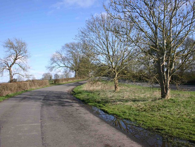
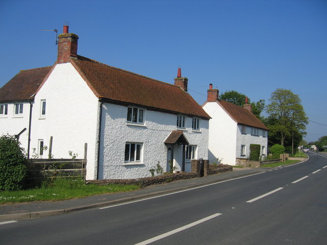
The village is characterized by its picturesque rural setting, surrounded by open farmland and rolling hills. It offers a peaceful and tranquil atmosphere, making it an ideal place for those seeking a quiet countryside lifestyle. The landscape is dotted with quaint cottages, historic farmhouses, and a few modern homes.

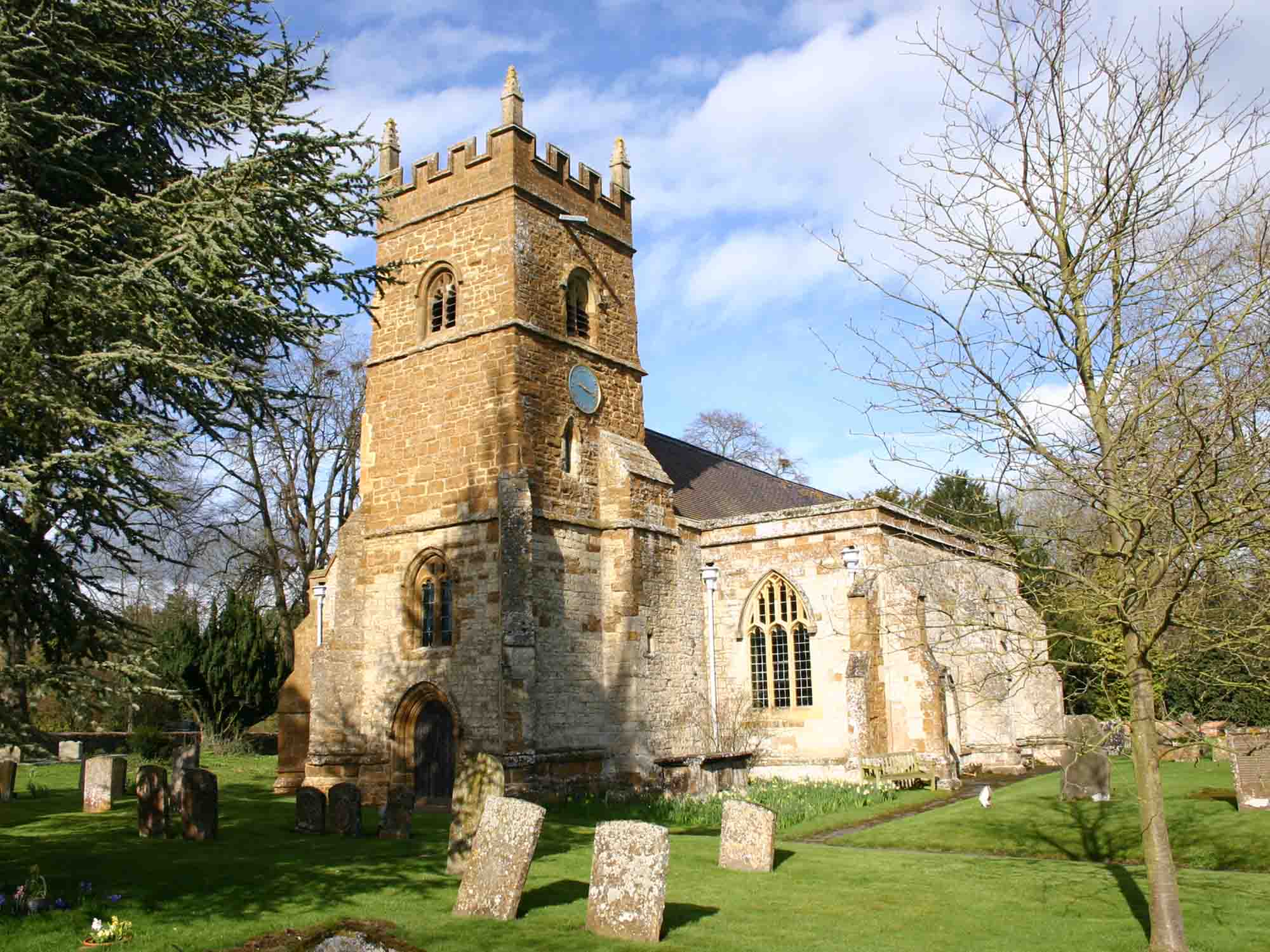
Pillerton Priors is home to the Holy Trinity Church, a beautiful medieval building that dates back to the 12th century. The church is a focal point of the village and holds regular services for the local community.

Though small in size, Pillerton Priors boasts a strong sense of community spirit. The village has a village hall, which serves as a hub for various social activities and events, bringing residents together. Additionally, there is a small primary school situated nearby, ensuring educational facilities are easily accessible to families in the area.

Despite its rural location, Pillerton Priors benefits from good transportation links. The nearby A429 road connects the village to nearby towns and cities, providing easy access to amenities and employment opportunities.

Overall, Pillerton Priors is a charming village that offers a peaceful countryside lifestyle, a strong community spirit, and convenient access to essential amenities.

If you have any feedback on the listing, please let us know in the comments section below.

Pillerton Priors Images

Images are sourced within 2km of 52.128496/-1.57006 or Grid Reference SP2947. Thanks to Geograph Open Source API. All images are credited.

Pillerton Hersey Ford
Footbridge over stream
Pillerton Hersey ford Taken 24-04-2005 on the day after the Cyclists' Touring Club's National Dinner
Pillerton Hersey ford
Taken 24-04-2005 on the day after the Cyclists' Touring Club's National Dinner
Oxhill Bridle Road This lane from Pillerton Hersey still eventually leads towards Oxhill as a track but its significance seems to have greatly diminished from that implied by the slightly grand name.
Oxhill Bridle Road
This lane from Pillerton Hersey still eventually leads towards Oxhill as a track but its significance seems to have greatly diminished from that implied by the slightly grand name.
Pillerton Hersey ford Taken a little later in the year than <a href="https://www.geograph.org.uk/photo/18384">SP3048 : Pillerton Hersey ford</a> and rather more obscured by greenery.
Pillerton Hersey ford
Taken a little later in the year than SP3048 : Pillerton Hersey ford and rather more obscured by greenery.
Park Slade Farm The entrance from the road to Pillerton Hersey.
Park Slade Farm
The entrance from the road to Pillerton Hersey.
Looking towards Sidelands Plantation Looking across the shallow valley across the north of the square toward Sidelands plantation on the rising ground in the square beyond.
Looking towards Sidelands Plantation
Looking across the shallow valley across the north of the square toward Sidelands plantation on the rising ground in the square beyond.
Haymaking at Nolands Farm Looking across from the lane to Oxhill with Sidelands Plantation on the hill top beyond.
Haymaking at Nolands Farm
Looking across from the lane to Oxhill with Sidelands Plantation on the hill top beyond.
BT repeater station Originally constructed to house amplifiers for long distance cable routes.  This type of building has now been largely made redundant with the advent of fibre optic transmission and the compact size of modern electronic equipment.
BT repeater station
Originally constructed to house amplifiers for long distance cable routes. This type of building has now been largely made redundant with the advent of fibre optic transmission and the compact size of modern electronic equipment.
View towards Newborough Farm Looking towards the NE corner of the square and Newborough Farm in the adjacent square.
View towards Newborough Farm
Looking towards the NE corner of the square and Newborough Farm in the adjacent square.
Track to Oxhill Farm Looking in the direction of the farm along the farm track and bridleway.
Track to Oxhill Farm
Looking in the direction of the farm along the farm track and bridleway.
Driveway to Nolands Farm Looking along the tree lined driveway from the northern edge of the square at the point at which the drive meets the lane to Oxhill.
Driveway to Nolands Farm
Looking along the tree lined driveway from the northern edge of the square at the point at which the drive meets the lane to Oxhill.
Nolands Farm Looking from the lane to Oxhill.
Nolands Farm
Looking from the lane to Oxhill.
View towards Bright Hill Looking across the square from the Stratford - Banbury road with the plantation on Bright Hill on the horizon.
View towards Bright Hill
Looking across the square from the Stratford - Banbury road with the plantation on Bright Hill on the horizon.
Footpath to Pillerton Hersey from A422 View north from the lay-by on the A422 up the footpath to Pillerton Hersey.
Footpath to Pillerton Hersey from A422
View north from the lay-by on the A422 up the footpath to Pillerton Hersey.
Footpath to Pillerton Hersey View north along the footpath towards Pillerton Hersey.
Footpath to Pillerton Hersey
View north along the footpath towards Pillerton Hersey.
Lay-by on A422 near Pillerton Priors These very large sweeping lay-bys are usually the result of the original route being straightened, and leaving a portion of the original road as a lay-by. Often white lines or cats-eyes can be seen, but in this case there was no such obvious evidence.
Lay-by on A422 near Pillerton Priors
These very large sweeping lay-bys are usually the result of the original route being straightened, and leaving a portion of the original road as a lay-by. Often white lines or cats-eyes can be seen, but in this case there was no such obvious evidence.
Pillerton Hersey ford Another completely different picture of the ford. See <a href="https://www.geograph.org.uk/photo/18384">SP3048 : Pillerton Hersey ford</a> and <a href="https://www.geograph.org.uk/photo/179177">SP3048 : Pillerton Hersey ford</a>. Here the stream has all but dried up, and the ford is merely a large puddle.
Pillerton Hersey ford
Another completely different picture of the ford. See SP3048 : Pillerton Hersey ford and SP3048 : Pillerton Hersey ford. Here the stream has all but dried up, and the ford is merely a large puddle.
Show me another place!

Pillerton Priors is located at Grid Ref: SP2947 (Lat: 52.128496, Lng: -1.57006)

Administrative County: Warwickshire

District: Stratford-on-Avon

Police Authority: Warwickshire

What 3 Words

///videos.nourished.dorm. Near Eattington, Warwickshire

Related Wikis

Pillerton Priors

Pillerton Priors or Over Pillerton is a settlement and civil parish 11 miles (18 km) south of Warwick, in the Stratford-on-Avon district, in the county...

Pillerton Hersey

Pillerton Hersey is a village and civil parish about 5.5 miles (9 km) north of Shipston-on-Stour in Warwickshire, England. The village is on a stream that...

Combrook

Combrook (also spelt Combroke and - more rarely - Combrooke) is a small village of about 65 houses in rural Warwickshire, located near the junction of...

Ettington

Ettington is a village and civil parish about 5.5 miles (9 km) south-east of Stratford-upon-Avon in Warwickshire, England. The 2011 Census recorded the...

Nearby Amenities

Located within 500m of 52.128496,-1.57006
Bus Stop
Walton Lane
Bus: yes
Naptan AtcoCode: 4200F052600
Naptan Bearing: NE
Naptan CommonName: Walton Lane
Naptan Indicator: Adj
Naptan NaptanCode: warawatg
Naptan Street: Kineton Road
Naptan Verified: no
Public Transport: platform
Source: naptan_import
Lat/Long: 52.1273728/-1.5733797
Walton Lane
Naptan AtcoCode: 4200F052601
Naptan Bearing: SW
Naptan BusStopType: CUS
Naptan CommonName: Walton Lane
Naptan Indicator: Opp
Naptan NaptanCode: wardjdwg
Naptan Street: Lineton Road
Naptan Verified: no
Source: naptan_import
Lat/Long: 52.1273133/-1.5732268
Saint Mary Magdalene
Historic: church
Source: NPE + Personal knowledge
Lat/Long: 52.1269628/-1.5709511
Pillerton Priors
Place: village
Source: OS_OpenData_StreetView
Lat/Long: 52.1265993/-1.5735999
Post Box
Collection Times: Mo-Fr 16:45; Sa 09:00
Operator: Royal Mail
Operator Wikidata: Q638098
Post Box Type: lamp
Ref: CV35 143
Royal Cypher: EIIR
Royal Cypher Wikidata: Q33102113
Source: survey
Lat/Long: 52.1258662/-1.5730051
Generator Method: photovoltaic
Generator Output Electricity: yes
Generator Source: solar
Generator Type: solar_photovoltaic_panel
Location: roof
Power: generator
Lat/Long: 52.1265775/-1.5733811
Generator Method: photovoltaic
Generator Output Electricity: yes
Generator Source: solar
Generator Type: solar_photovoltaic_panel
Location: roof
Power: generator
Lat/Long: 52.1265397/-1.5730271
Generator Method: photovoltaic
Generator Output Electricity: yes
Generator Source: solar
Generator Type: solar_photovoltaic_panel
Location: roof
Power: generator
Lat/Long: 52.1257657/-1.5731397
Generator Method: photovoltaic
Generator Output Electricity: yes
Generator Source: solar
Generator Type: solar_photovoltaic_panel
Location: roof
Power: generator
Lat/Long: 52.1254825/-1.5727803
Generator Method: photovoltaic
Generator Output Electricity: yes
Generator Source: solar
Generator Type: solar_photovoltaic_panel
Location: roof
Power: generator
Lat/Long: 52.1263767/-1.5740141
Give Way
Direction: forward
Source: Warwicks CC Aerial Imagery 2013
Lat/Long: 52.1260967/-1.5745962
Generator Method: photovoltaic
Generator Output Electricity: yes
Generator Source: solar
Generator Type: solar_photovoltaic_panel
Location: roof
Power: generator
Lat/Long: 52.1281336/-1.5726569
Give Way
Direction: backward
Source: Warwicks CC Aerial Imagery 2013
Lat/Long: 52.1261389/-1.57118
Give Way
Direction: backward
Source: Warwicks CC Aerial Imagery 2013
Lat/Long: 52.1261051/-1.5714738
Give Way
Direction: forward
Source: Warwicks CC Aerial Imagery 2013
Lat/Long: 52.126087/-1.5717323
Give Way
Direction: forward
Source: Warwicks CC Aerial Imagery 2013
Lat/Long: 52.127039/-1.5734287
Give Way
Direction: backward
Source: Warwicks CC Aerial Imagery 2013
Lat/Long: 52.1259666/-1.5745797
Material: wood
Power: pole
Ref: 774284
Source: wpd_opendata
Transformer: distribution
Lat/Long: 52.1253928/-1.5732933
Material: wood
Power: pole
Source: bing
Lat/Long: 52.1253038/-1.5742341
Generator Method: photovoltaic
Generator Output Electricity: yes
Generator Source: solar
Generator Type: solar_photovoltaic_panel
Location: roof
Power: generator
Lat/Long: 52.1280875/-1.5715975
Material: wood
Power: pole
Ref: 774282
Source: wpd_opendata
Transformer: distribution
Lat/Long: 52.1275318/-1.5703905
Material: wood
Power: pole
Source: bing
Lat/Long: 52.127969/-1.5701008
Material: wood
Power: pole
Source: bing
Lat/Long: 52.1286128/-1.5697441
Material: wood
Power: pole
Source: bing
Lat/Long: 52.1315189/-1.5646318
Material: wood
Power: pole
Source: bing
Lat/Long: 52.1309492/-1.565415
Material: wood
Power: pole
Source: bing
Lat/Long: 52.1303631/-1.566276
Material: wood
Power: pole
Ref: 774280
Transformer: distribution
Lat/Long: 52.1299926/-1.5678115
Material: wood
Power: pole
Source: bing
Lat/Long: 52.1298181/-1.5671182
Material: wood
Power: pole
Source: bing
Lat/Long: 52.1294064/-1.5678611
Material: wood
Power: pole
Source: bing
Lat/Long: 52.1290047/-1.5685706
Material: wood
Power: pole
Ref: 774296
Transformer: distribution
Lat/Long: 52.1267381/-1.575079
Material: wood
Power: pole
Source: bing
Lat/Long: 52.1271917/-1.5748416
Material: wood
Power: pole
Source: bing
Lat/Long: 52.1276594/-1.5746015
Material: wood
Power: pole
Ref: 774290
Source: wpd_opendata
Transformer: distribution
Lat/Long: 52.129618/-1.5770651
Material: wood
Power: pole
Source: bing
Lat/Long: 52.1288178/-1.5771604
Material: wood
Power: pole
Source: bing
Lat/Long: 52.1279978/-1.5772247
Material: wood
Power: pole
Source: bing
Lat/Long: 52.1278249/-1.5759279
Material: wood
Power: pole
Source: bing
Lat/Long: 52.1281748/-1.574906
Material: wood
Power: pole
Source: bing
Lat/Long: 52.1285181/-1.573927
Material: wood
Power: pole
Ref: 774294
Source: wpd_opendata
Transformer: distribution
Lat/Long: 52.1288169/-1.5729721
Material: wood
Power: pole
Source: bing
Lat/Long: 52.1291767/-1.5718456
Material: wood
Power: pole
Source: bing
Lat/Long: 52.1295563/-1.5706828
Material: wood
Power: pole
Source: bing
Lat/Long: 52.1292426/-1.5693659
Generator Method: photovoltaic
Generator Output Electricity: yes
Generator Source: solar
Generator Type: solar_photovoltaic_panel
Location: roof
Power: generator
Lat/Long: 52.1296007/-1.5764228
Give Way
Direction: forward
Lat/Long: 52.1275655/-1.5729864
Give Way
Direction: backward
Lat/Long: 52.1274568/-1.5732561
The data included in this document is from www.openstreetmap.org. The data is made available under ODbL.

Have you been to Pillerton Priors?

Leave your review of Pillerton Priors below (or comments, questions and feedback).