Broughton Poggs

Settlement in Oxfordshire West Oxfordshire

England

Broughton Poggs

Village sign in Filkins Village sign entering Filkins from the north.
Village sign in Filkins Credit: Kevin Pearson

Broughton Poggs is a picturesque village located in the county of Oxfordshire, England. Situated approximately 8 miles west of the city of Oxford, the village is nestled in the tranquil Windrush Valley. Broughton Poggs is part of the larger civil parish of Filkins and Broughton Poggs.

Known for its charming countryside setting, Broughton Poggs offers a quintessential English village experience. The village features a collection of traditional Cotswold stone cottages, which add to its aesthetic appeal. The surrounding landscape is characterized by rolling hills, lush green fields, and meandering streams, providing a serene environment for residents and visitors alike.

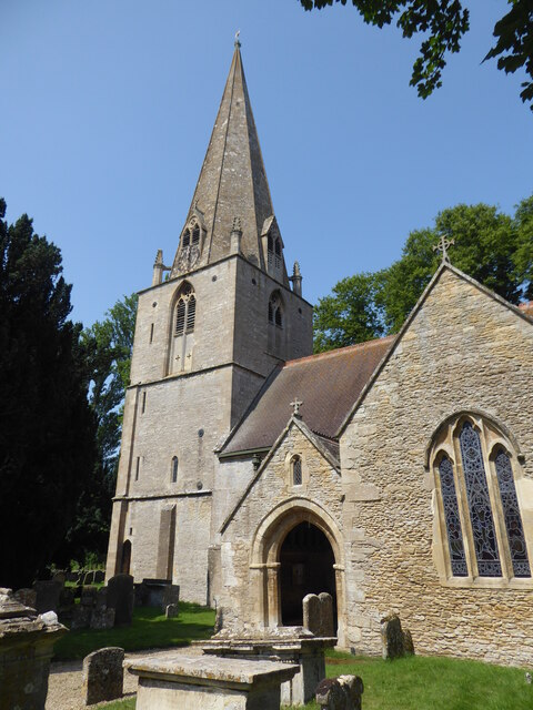
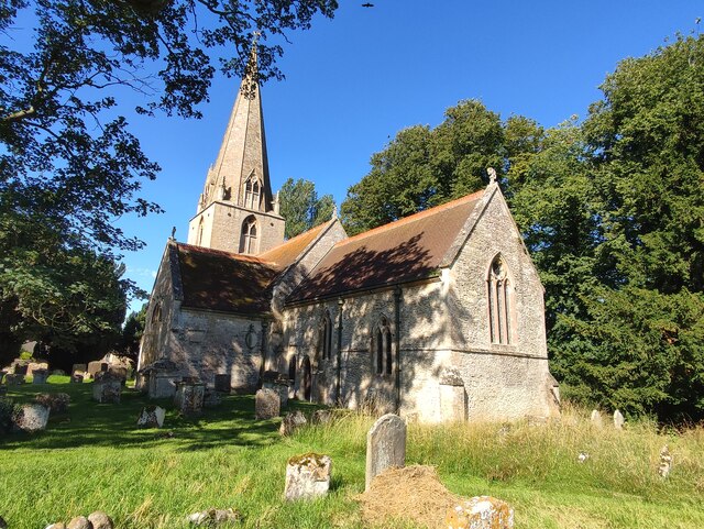
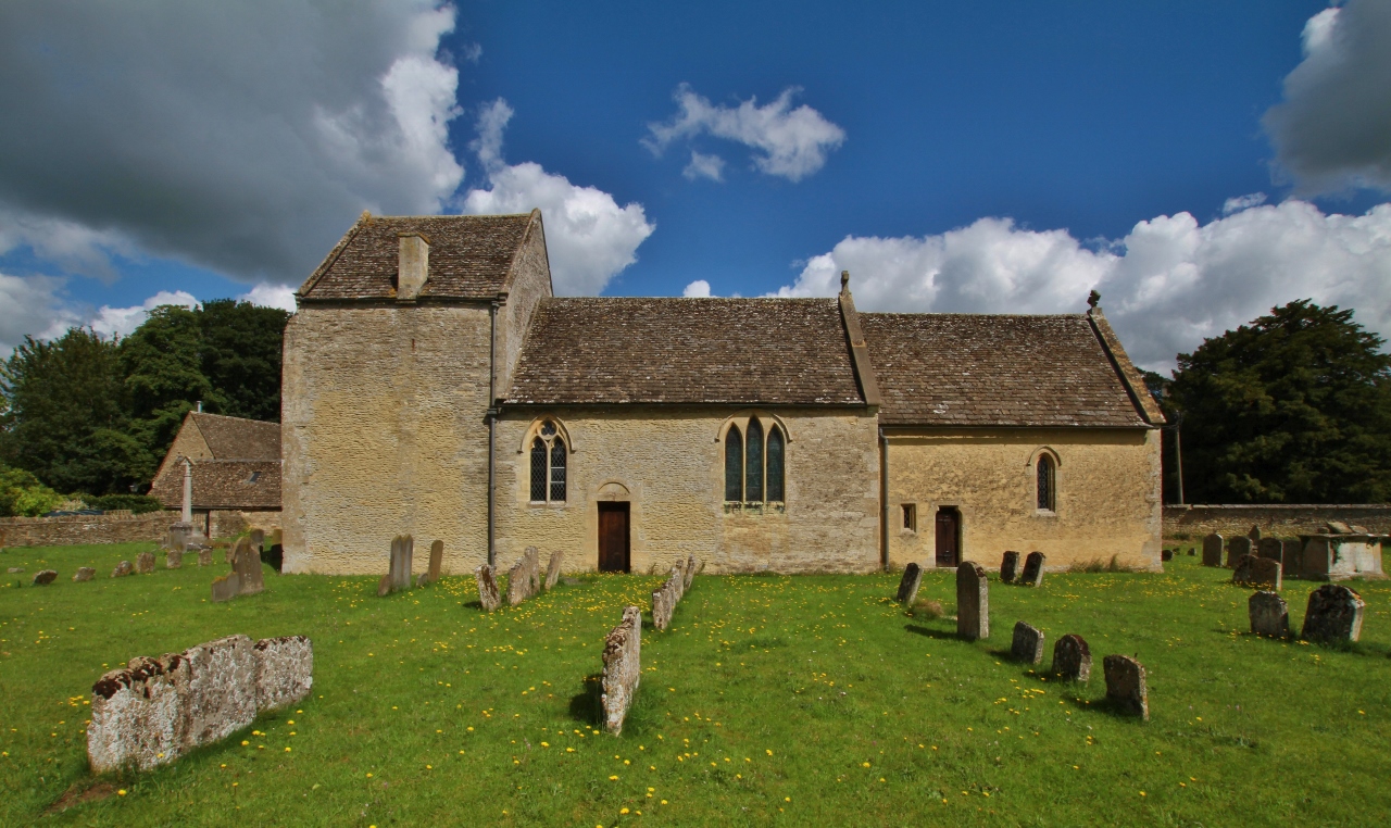
Although small in size, Broughton Poggs boasts a tight-knit community that is proud of its heritage. The village is home to the historic St. Peter's Church, a Grade II listed building dating back to the 12th century. This ancient place of worship serves as a reminder of the village's rich history.

The village is also renowned for its agricultural heritage, with farming playing a significant role in the local economy. Many residents are involved in agricultural pursuits, cultivating crops or tending to livestock.

For those seeking outdoor pursuits, Broughton Poggs offers ample opportunities for walking and exploring the natural beauty of the surrounding countryside. Nearby attractions include the Cotswold Wildlife Park and Gardens, which is a short drive away.

Overall, Broughton Poggs captures the essence of a traditional English village, with its idyllic setting, historic charm, and strong sense of community.

If you have any feedback on the listing, please let us know in the comments section below.

Broughton Poggs Images

Images are sourced within 2km of 51.733859/-1.663002 or Grid Reference SP2303. Thanks to Geograph Open Source API. All images are credited.

Village sign in Filkins Village sign entering Filkins from the north.
Village sign in Filkins
Village sign entering Filkins from the north.
Broadwell, St Peter & St Paul
Stone Stile, Broughton Poggs In the village of Filkins, just NE of Oxfordshire footpath 212/8/20, looking SW over to the footpath. The view NE is <a href="https://www.geograph.org.uk/photo/7226679">SP2304 : Stone Stile, Broughton Poggs</a>.
Stone Stile, Broughton Poggs
In the village of Filkins, just NE of Oxfordshire footpath 212/8/20, looking SW over to the footpath. The view NE is SP2304 : Stone Stile, Broughton Poggs.
Stone Stile, Broughton Poggs In the village of Filkins, just NE of Oxfordshire footpath 212/8/20, looking NE from the footpath. The view SW is <a href="https://www.geograph.org.uk/photo/7226678">SP2304 : Stone Stile, Broughton Poggs</a>.
Stone Stile, Broughton Poggs
In the village of Filkins, just NE of Oxfordshire footpath 212/8/20, looking NE from the footpath. The view SW is SP2304 : Stone Stile, Broughton Poggs.
Stone Stile, Broughton Poggs In the village of Filkins, on Oxfordshire footpath 212/8/20 as it exits the alley adjacent to Well Cottage onto a field. Looking to the field, the alternative view looking into the alley is <a href="https://www.geograph.org.uk/photo/7316852">SP2304 : Stone Stile, Broughton Poggs</a>.
Stone Stile, Broughton Poggs
In the village of Filkins, on Oxfordshire footpath 212/8/20 as it exits the alley adjacent to Well Cottage onto a field. Looking to the field, the alternative view looking into the alley is SP2304 : Stone Stile, Broughton Poggs.
Stone Stile, Broughton Poggs GS6003 Looking SW off Rouses Lane, Filkins village. Not on a recognised footpath. The stile is not on a recognised footpath, though the desire lines visible on satellite images show it is well used. This view looks from the road, the view looking back is <a href="https://www.geograph.org.uk/photo/7316779">SP2304 : Stone Stile, Broughton Poggs GS6003</a>.
Stone Stile, Broughton Poggs GS6003
Looking SW off Rouses Lane, Filkins village. Not on a recognised footpath. The stile is not on a recognised footpath, though the desire lines visible on satellite images show it is well used. This view looks from the road, the view looking back is SP2304 : Stone Stile, Broughton Poggs GS6003.
Stone Stile, Broughton Poggs GS6003 Looking SW off Rouses Lane (Oxfordshire footpath 212/9/30), Filkins village. The stile is not on a recognised footpath, though the desire lines visible on satellite images show it is well used. This view looks to the road, the view looking back is <a href="https://www.geograph.org.uk/photo/7226716">SP2304 : Stone Stile, Broughton Poggs GS6003</a>.
Stone Stile, Broughton Poggs GS6003
Looking SW off Rouses Lane (Oxfordshire footpath 212/9/30), Filkins village. The stile is not on a recognised footpath, though the desire lines visible on satellite images show it is well used. This view looks to the road, the view looking back is SP2304 : Stone Stile, Broughton Poggs GS6003.
Stone Stile, Broughton Poggs On Oxfordshire footpath 212/9/30, in the Rouses Lane Woods. The view from the other side is <a href="https://www.geograph.org.uk/photo/7316808">SP2304 : Stone Stile, Broughton Poggs</a>.
Stone Stile, Broughton Poggs
On Oxfordshire footpath 212/9/30, in the Rouses Lane Woods. The view from the other side is SP2304 : Stone Stile, Broughton Poggs.
Stone Stile, Broughton Poggs On Oxfordshire footpath 212/9/30, in the Rouses Lane Woods. The view from the other side is <a href="https://www.geograph.org.uk/photo/7316806">SP2304 : Stone Stile, Broughton Poggs</a>.
Stone Stile, Broughton Poggs
On Oxfordshire footpath 212/9/30, in the Rouses Lane Woods. The view from the other side is SP2304 : Stone Stile, Broughton Poggs.
Stone Stile, Broughton Poggs A little private step stile as a shortcut to the owner's drive.
Stone Stile, Broughton Poggs
A little private step stile as a shortcut to the owner's drive.
Stone Stile, Broughton Poggs In the village of Filkins, on Oxfordshire footpath 212/8/20 as it exits the alley adjacent to Well Cottage onto a field. This is looking down the alley, the view to the field is <a href="https://www.geograph.org.uk/photo/7226703">SP2304 : Stone Stile, Broughton Poggs</a>.
Stone Stile, Broughton Poggs
In the village of Filkins, on Oxfordshire footpath 212/8/20 as it exits the alley adjacent to Well Cottage onto a field. This is looking down the alley, the view to the field is SP2304 : Stone Stile, Broughton Poggs.
St Peter's Church, Filkins
St Peter and St Paul's Church, Broadwell
Filkins swimming pool Unheated outdoor pool, therefore tending to be COLD! Unoccupied on a day of sunshine and heavy showers in mid June.
Filkins swimming pool
Unheated outdoor pool, therefore tending to be COLD! Unoccupied on a day of sunshine and heavy showers in mid June.
Road to Langford Downs Farm
The Coach House at the end of the road, Broughton Poggs
St Peter's church, Broughton Poggs As the web site says "The church at Broughton Poggs takes some finding, standing as it does beyond a farmyard and reached by a lane". Worth the visit though. <span class="nowrap"><a title="http://www.filkins.org.uk/church_st_peters_bp.html" rel="nofollow ugc noopener" href="http://www.filkins.org.uk/church_st_peters_bp.html">Link</a><img style="margin-left:2px;" alt="External link" title="External link - shift click to open in new window" src="https://s1.geograph.org.uk/img/external.png" width="10" height="10"/></span>
St Peter's church, Broughton Poggs
As the web site says "The church at Broughton Poggs takes some finding, standing as it does beyond a farmyard and reached by a lane". Worth the visit though. LinkExternal link
View of the interior of St Peter's church
Show me another place!

Broughton Poggs is located at Grid Ref: SP2303 (Lat: 51.733859, Lng: -1.663002)

Administrative County: Oxfordshire

District: West Oxfordshire

Police Authority: Thames Valley

What 3 Words

///clasps.boosted.vessel. Near Lechlade, Gloucestershire

Nearby Locations

Broughton Poggs

Related Wikis

Broughton Poggs

Broughton Poggs is a village in the civil parish of Filkins and Broughton Poggs in West Oxfordshire. Broughton Poggs is 3 miles (5 km) southwest of Carterton...

Filkins and Broughton Poggs

Filkins and Broughton Poggs is a civil parish in West Oxfordshire, on the Oxfordshire county boundary with Gloucestershire. The parish includes the villages...

Swinford Museum

The Swinford Museum is a small museum in the village of Filkins, west Oxfordshire, England.The collection covers local domestic, agricultural, trade and...

Filkins

For people with the surname, see Filkins (surname). Filkins is a village in the civil parish of Filkins and Broughton Poggs, about 2.5 miles (4 km) southwest...

Broadwell, Oxfordshire

Broadwell is a village and civil parish about 2 miles (3 km) south-west of Carterton in West Oxfordshire. The 2011 Census recorded the parish's population...

Langford, Oxfordshire

Langford is a village and civil parish in West Oxfordshire, about 3 miles (5 km) northeast of Lechlade in neighbouring Gloucestershire. The 2011 Census...

St Matthew's Church, Langford

The Parish Church of Saint Matthew, Langford is the Church of England parish church of Langford, a village in West Oxfordshire about 3 miles (5 km) northeast...

Little Faringdon

Little Faringdon is a village and civil parish in West Oxfordshire, about 1 mile (1.6 km) north of Lechlade in neighbouring Gloucestershire. The 2001 Census...

Nearby Amenities

Located within 500m of 51.733859,-1.663002
Bus Stop
War Memorial
Bus: yes
Naptan AtcoCode: 340000314BEA
Naptan Bearing: NE
Naptan BusStopType: CUS
Naptan CommonName: War Memorial
Naptan Indicator: Opp Bus Shelter
Naptan Landmark: Opp Bus Shelter
Naptan NaptanCode: oxfamatm
Naptan Street: Village Road
Naptan Verified: no
Public Transport: platform
Source: naptan_import
Lat/Long: 51.7360258/-1.6567498
The Church
Naptan AtcoCode: 340000314CHU
Naptan Bearing: W
Naptan BusStopType: CUS
Naptan CommonName: The Church
Naptan Indicator: Outside
Naptan Landmark: The Church
Naptan NaptanCode: oxfamamg
Naptan Street: unclassified road
Naptan Verified: no
Source: naptan_import
Lat/Long: 51.7338875/-1.6610909
The Church
Naptan AtcoCode: 340000314OPC
Naptan Bearing: E
Naptan BusStopType: CUS
Naptan CommonName: The Church
Naptan Indicator: Opposite
Naptan Landmark: The Church
Naptan NaptanCode: oxfamamd
Naptan Street: unclassified road
Naptan Verified: no
Source: naptan_import
Lat/Long: 51.7339678/-1.6608731
Entrance: main
Lat/Long: 51.7358196/-1.6579853
Historic: memorial
Source: survey
Lat/Long: 51.736047/-1.6568025
Broughton Poggs
Place: village
Lat/Long: 51.7329172/-1.6619054
Material: wood
Power: pole
Source: Bing
Lat/Long: 51.7323028/-1.6696589
Material: wood
Power: pole
Source: Bing
Lat/Long: 51.7330204/-1.6683284
Material: wood
Power: pole
Source: Bing
Lat/Long: 51.7342231/-1.6558105
Material: wood
Power: pole
Source: Bing
Lat/Long: 51.7336617/-1.6580046
Morley Clive Harps
Contact Phone: +44 1367 860493
Shop: musical_instrument
Website: https://www.morleyharps.co.uk/
Lat/Long: 51.7375463/-1.6599648
Bus Stop
War Memorial
Bus: yes
Public Transport: platform
Lat/Long: 51.7358845/-1.656583
Post Box
Operator: Royal Mail
Post Box Type: wall
Ref: GL7 90D
Royal Cypher: GR
Royal Cypher Wikidata: Q33102273
Lat/Long: 51.7329739/-1.6629776
The data included in this document is from www.openstreetmap.org. The data is made available under ODbL.

Have you been to Broughton Poggs?

Leave your review of Broughton Poggs below (or comments, questions and feedback).