Broughton

Settlement in Oxfordshire Cherwell

England

Broughton

Broughton Park and St. Mary's church
Broughton Park and St. Mary's church Credit: Jonathan Thacker

Broughton is a small village located in the Cherwell Valley of Oxfordshire, England. Situated approximately 10 miles southwest of the city of Banbury, it belongs to the civil parish of North Newington. The village is surrounded by picturesque countryside, with rolling hills and farmland dominating the landscape.

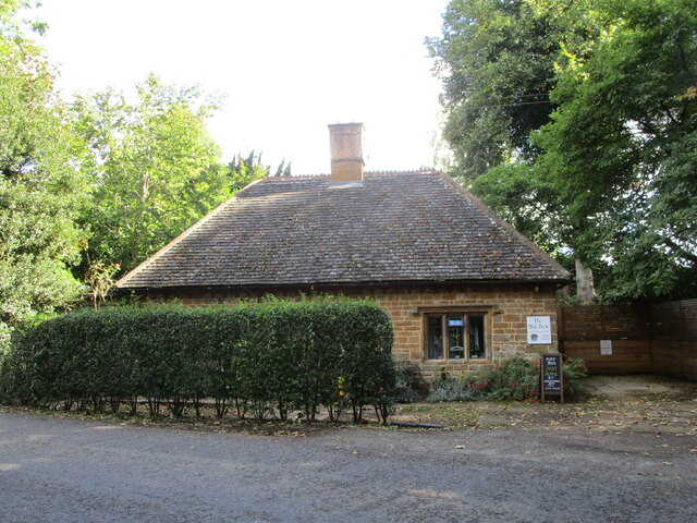
Historically, Broughton has been a rural settlement, its origins dating back to the medieval period. It is mentioned in the Domesday Book of 1086, where it is referred to as "Broctone." The village has retained much of its traditional charm, with a number of well-preserved thatched cottages and historic buildings lining its streets.

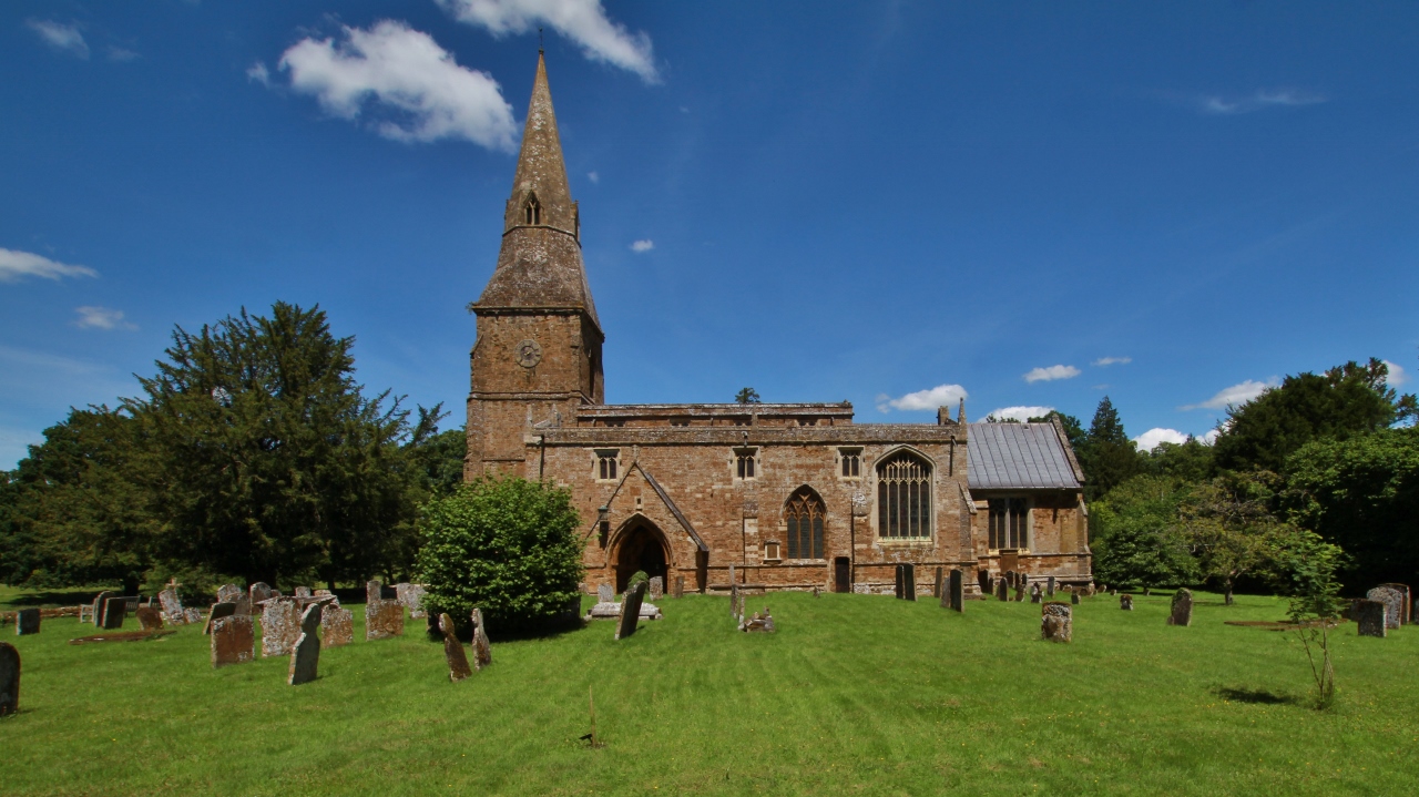
The heart of Broughton is its parish church, St. Mary's, which dates back to the 12th century. This beautiful Norman church features a striking tower and hosts regular services for the local community. The village also boasts a primary school, providing education for the younger residents.

Broughton is a close-knit community that enjoys a peaceful and tranquil atmosphere. The village offers a range of amenities to its residents, including a local pub, The Saye and Sele Arms, which serves as a social hub. The surrounding countryside provides ample opportunities for outdoor activities such as walking, cycling, and horse riding.

Although Broughton may be small in size, its rich history, scenic surroundings, and sense of community make it a charming place to live or visit, offering a peaceful escape from the hustle and bustle of nearby urban areas.

If you have any feedback on the listing, please let us know in the comments section below.

Broughton Images

Images are sourced within 2km of 52.042495/-1.383033 or Grid Reference SP4238. Thanks to Geograph Open Source API. All images are credited.

Broughton Park and St. Mary's church
The Hat Box, Broughton Nineteenth century cottage.
The Hat Box, Broughton
Nineteenth century cottage.
Harrowed field near North Newington Mill
Fields near Broughton
Lodge to Broughton Castle Dates from about 1840 <span class="nowrap"><a title="https://historicengland.org.uk/listing/the-list/list-entry/1277776" rel="nofollow ugc noopener" href="https://historicengland.org.uk/listing/the-list/list-entry/1277776">Link</a><img style="margin-left:2px;" alt="External link" title="External link - shift click to open in new window" src="https://s1.geograph.org.uk/img/external.png" width="10" height="10"/></span>
Lodge to Broughton Castle
Dates from about 1840 LinkExternal link
Roadway in Broughton Park
Broughton Park Even when the castle is closed to visitors the park is often open to the public.
Broughton Park
Even when the castle is closed to visitors the park is often open to the public.
The moat, Broughton Castle
The moat and gatehouse, Broughton Castle The gatehouse and most of the features around it date from the fourteenth century <span class="nowrap"><a title="https://historicengland.org.uk/listing/the-list/list-entry/1248762" rel="nofollow ugc noopener" href="https://historicengland.org.uk/listing/the-list/list-entry/1248762">Link</a><img style="margin-left:2px;" alt="External link" title="External link - shift click to open in new window" src="https://s1.geograph.org.uk/img/external.png" width="10" height="10"/></span>
The moat and gatehouse, Broughton Castle
The gatehouse and most of the features around it date from the fourteenth century LinkExternal link
Avenue leading to the gatehouse, Broughton Castle
Church of St. Mary the Virgin, Broughton Dates from about 1300 with later additions and alterations <span class="nowrap"><a title="https://historicengland.org.uk/listing/the-list/list-entry/1248778" rel="nofollow ugc noopener" href="https://historicengland.org.uk/listing/the-list/list-entry/1248778">Link</a><img style="margin-left:2px;" alt="External link" title="External link - shift click to open in new window" src="https://s1.geograph.org.uk/img/external.png" width="10" height="10"/></span>
The church is close to the castle but some distance from the village.
Church of St. Mary the Virgin, Broughton
Dates from about 1300 with later additions and alterations LinkExternal link The church is close to the castle but some distance from the village.
Footpath from the church to the village, Broughton
Warren Lodge, Broughton Designed by George Gilbert Scott junior in 1877.
Warren Lodge, Broughton
Designed by George Gilbert Scott junior in 1877.
Almshouses, Broughton Built in 1859 as a result of the benefaction of Elizabeth Bradford-Wyatt <span class="nowrap"><a title="https://historicengland.org.uk/listing/the-list/list-entry/1248764" rel="nofollow ugc noopener" href="https://historicengland.org.uk/listing/the-list/list-entry/1248764">Link</a><img style="margin-left:2px;" alt="External link" title="External link - shift click to open in new window" src="https://s1.geograph.org.uk/img/external.png" width="10" height="10"/></span>
Almshouses, Broughton
Built in 1859 as a result of the benefaction of Elizabeth Bradford-Wyatt LinkExternal link
Junction of power lines near North Newington Mill
Traffic lights on Bloxham Road Temporary traffic lights on the A361 while a roundabout is developed giving access to the new Bloxham Vale housing development to the right. This is now the edge of the Banbury conurbation.
Traffic lights on Bloxham Road
Temporary traffic lights on the A361 while a roundabout is developed giving access to the new Bloxham Vale housing development to the right. This is now the edge of the Banbury conurbation.
Tyrrell Road Part of the new Bloxham Vale housing development.
Tyrrell Road
Part of the new Bloxham Vale housing development.
Adams Close Part of the new Bloxham Vale housing development. This is also the route of a pre-existing public footpath which links up with the Salt Way.
Adams Close
Part of the new Bloxham Vale housing development. This is also the route of a pre-existing public footpath which links up with the Salt Way.
Show me another place!

Broughton is located at Grid Ref: SP4238 (Lat: 52.042495, Lng: -1.383033)

Administrative County: Oxfordshire

District: Cherwell

Police Authority: Thames Valley

What 3 Words

///cabinets.verb.joggers. Near Bloxham, Oxfordshire

Nearby Locations

Broughton

Related Wikis

Broughton, Oxfordshire

Broughton is a village and civil parish in northern Oxfordshire, England, about 2+1⁄2 miles (4 km) southwest of Banbury. The 2011 Census recorded the...
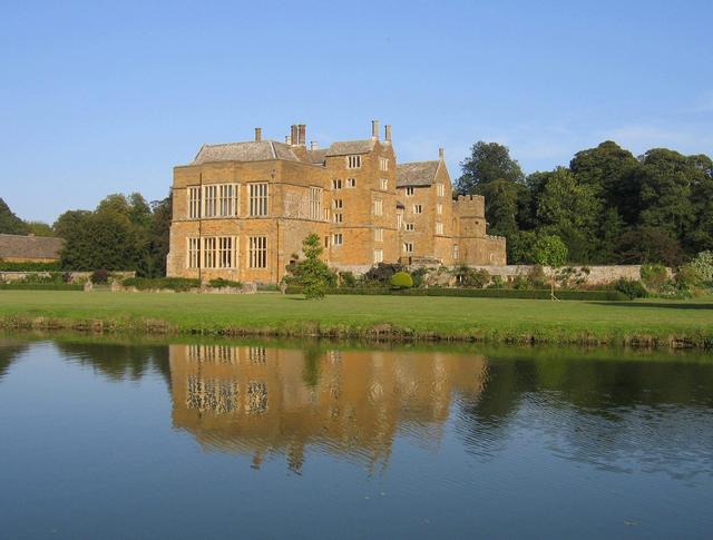
Broughton Castle

Broughton Castle is a medieval fortified manor house in the village of Broughton, which is about two miles south-west of Banbury in Oxfordshire, England...

North Newington

North Newington is a village and civil parish in northern Oxfordshire, England, about 2 miles (3 km) west of Banbury. The 2011 Census recorded the parish...

Tudor Hall School, Banbury

Tudor Hall School is a private day and boarding school for girls in Oxfordshire, situated between Bloxham and Banbury. It was founded by a Baptist Minister...

Crouch Hill, Banbury

Crouch Hill (The name of the hill comes from the Celtic "crug", meaning hill.) is a partly artificial hill one mile to the south-west of Banbury Church...

The Warriner School

The Warriner School is a coeducational secondary school situated in Bloxham, Oxfordshire, England. The school was founded in 1971 and now has 1,500 pupils...

Bloxham School

Bloxham School, also called All Saints' School, is a private co-educational day and boarding school of the British public school tradition, located in...

Neithrop

Neithrop is an inner housing estate and part of the greater 'Neithrop ward' of Banbury, Oxfordshire, England. It is one of the oldest areas in Banbury...

Nearby Amenities

Located within 500m of 52.042495,-1.383033
Broughton
Place: village
Lat/Long: 52.0431823/-1.3861381
Danvers Road
Naptan AtcoCode: 340001474CNR
Naptan Bearing: SW
Naptan BusStopType: CUS
Naptan CommonName: Danvers Road
Naptan Indicator: Corner
Naptan Landmark: Danvers Road
Naptan NaptanCode: oxfagtwj
Naptan Street: Main Road
Naptan Verified: no
Source: naptan_import
Lat/Long: 52.0442867/-1.3850039
Danvers Road
Naptan AtcoCode: 340001474OPP
Naptan Bearing: NE
Naptan BusStopType: CUS
Naptan CommonName: Danvers Road
Naptan Indicator: Opposite
Naptan Landmark: Danvers Road
Naptan NaptanCode: oxfagtwg
Naptan Street: Main Road
Naptan Verified: no
Source: naptan_import
Lat/Long: 52.0443143/-1.3851202
Bus Stop
Wykham Lane
Bench: no
Bin: no
Bus: yes
Check Date Bin: 2022-08-17
Lit: no
Naptan AtcoCode: 340001475CNR
Naptan Bearing: NE
Naptan BusStopType: CUS
Naptan CommonName: Wykham Lane
Naptan Indicator: Corner
Naptan Landmark: Pub
Naptan NaptanCode: oxfagtwd
Naptan Street: Main Road
Naptan Verified: no
Public Transport: platform
Shelter: no
Source: naptan_import
Tactile Paving: no
Lat/Long: 52.0426359/-1.3874178
Bus Stop
Wykham Lane
Bench: no
Bin: no
Bus: yes
Check Date Bench: 2022-08-17
Lit: no
Naptan AtcoCode: 340001475OPP
Naptan Bearing: SW
Naptan BusStopType: CUS
Naptan CommonName: Wykham Lane
Naptan Indicator: Opposite
Naptan Landmark: Pub
Naptan NaptanCode: oxfagtdw
Naptan Street: Main Road
Naptan Verified: no
Public Transport: platform
Shelter: no
Source: naptan_import
Tactile Paving: no
Lat/Long: 52.0426008/-1.3875786
Rectory Farm
Building: farm
Source: OS_OpenData_StreetView
Lat/Long: 52.0412047/-1.3806134
Barrier: stile
Material: wood
Stile: stepover
Lat/Long: 52.0453948/-1.3838681
Material: wood
Power: pole
Source: Bing
Lat/Long: 52.0390114/-1.382746
Material: wood
Power: pole
Source: Bing
Lat/Long: 52.0404417/-1.3823544
Material: wood
Power: pole
Source: Bing
Lat/Long: 52.038155/-1.3831832
Material: wood
Power: pole
Source: Bing
Lat/Long: 52.0463839/-1.3820137
Material: wood
Power: pole
Source: Bing
Lat/Long: 52.0439806/-1.3829713
Material: wood
Power: pole
Source: Bing
Lat/Long: 52.0424446/-1.3822739
Material: wood
Power: pole
Source: Bing
Lat/Long: 52.0397241/-1.3823919
Material: wood
Power: pole
Source: Bing
Lat/Long: 52.0449577/-1.3821561
Material: wood
Power: pole
Source: Bing
Lat/Long: 52.0467125/-1.3854955
Material: wood
Power: pole
Source: Bing
Lat/Long: 52.0418829/-1.3819701
Material: wood
Power: pole
Source: Bing
Lat/Long: 52.0418936/-1.3823185
Material: wood
Power: pole
Source: Bing
Lat/Long: 52.045734/-1.3820888
Material: wood
Power: pole
Source: Bing
Lat/Long: 52.044091/-1.3821613
Material: wood
Power: pole
Source: Bing
Lat/Long: 52.0411892/-1.3823168
Material: wood
Power: pole
Source: Bing
Lat/Long: 52.0432233/-1.3822176
Material: wood
Power: pole
Source: Bing
Lat/Long: 52.0419167/-1.3845055
Post Box
Brand: Royal Mail
Brand Wikidata: Q638098
Brand Wikipedia: en:Royal Mail
Collection Times: Mo-Fr 09:00; Sa 09:00
Operator: Royal Mail
Operator Wikidata: Q638098
Post Box Type: wall
Ref: OX15 1070D
Royal Cypher: GVIR
Royal Cypher Wikidata: Q33102169
Source: drive-by survey
Lat/Long: 52.0426829/-1.3876179
Material: wood
Power: pole
Lat/Long: 52.0418612/-1.3809927
Material: wood
Power: pole
Lat/Long: 52.0419187/-1.3831311
Turning Loop
Lat/Long: 52.041737/-1.3892882
Material: wood
Power: pole
Lat/Long: 52.041034/-1.3796263
Material: wood
Power: pole
Lat/Long: 52.04029/-1.3789669
Material: wood
Power: pole
Lat/Long: 52.0395688/-1.3783192
Defibrillator
Emergency: defibrillator
Indoor: no
Lat/Long: 52.0425135/-1.3879135
Fire Hydrant
Emergency: fire_hydrant
Fire Hydrant Position: sidewalk
Fire Hydrant Type: underground
Water Source: main
Lat/Long: 52.0438031/-1.3857469
The data included in this document is from www.openstreetmap.org. The data is made available under ODbL.

Have you been to Broughton?

Leave your review of Broughton below (or comments, questions and feedback).