Broomfield

Settlement in Kent Canterbury

England

Broomfield

Hillborough buildings [1] The church of St Mary the Virgin in Reculver Lane was built in 1878. Constructed, as a Gothic Revival church in the Early English style, of knapped flint with limestone dressings under a tile roof. The south doorway is a 13th century one reused from the ancient church at Reculver as are a few stones at the junction of the nave and chancel. Listed, grade II, with details at: <span class="nowrap"><a title="https://historicengland.org.uk/listing/the-list/list-entry/1318906" rel="nofollow ugc noopener" href="https://historicengland.org.uk/listing/the-list/list-entry/1318906">Link</a><img style="margin-left:2px;" alt="External link" title="External link - shift click to open in new window" src="https://s1.geograph.org.uk/img/external.png" width="10" height="10"/></span>
Hillborough is a suburb of the town of Herne Bay, a seaside town on the Thames Estuary, some 6 miles north of Canterbury and about 4 miles east of Whitstable. It neighbours the ancient villages of Herne and Reculver.
Hillborough buildings [1] Credit: Michael Dibb

Broomfield is a small village located in the county of Kent, in southeastern England. Situated approximately 5 miles northeast of the bustling town of Maidstone, Broomfield offers residents a peaceful and picturesque rural setting.

The village is nestled within the Kent Downs Area of Outstanding Natural Beauty, surrounded by rolling hills, lush meadows, and green woodlands. This idyllic landscape makes it a popular destination for nature lovers and outdoor enthusiasts. The nearby Pilgrims Way, a historic long-distance footpath, provides opportunities for scenic walks and hikes.

Broomfield itself is a tight-knit community with a population of around 1,500 residents. The village features a charming parish church, St. Margaret's, which dates back to the 12th century and serves as a focal point for local events and gatherings. The churchyard is known for its beautiful gardens and is often frequented by visitors seeking a tranquil spot for reflection.

Although small in size, Broomfield offers a range of amenities for its residents. These include a primary school, a village hall, and a local pub that serves as a hub for socializing and community events. Additionally, the village is within easy reach of Maidstone, where residents can access a wider range of services, shopping centers, and entertainment options.

Overall, Broomfield's scenic beauty, close-knit community, and convenient location make it an attractive place to live for those seeking a peaceful and rural lifestyle within easy reach of urban amenities.

If you have any feedback on the listing, please let us know in the comments section below.

Broomfield Images

Images are sourced within 2km of 51.357669/1.155661 or Grid Reference TR1966. Thanks to Geograph Open Source API. All images are credited.

Hillborough buildings [1] The church of St Mary the Virgin in Reculver Lane was built in 1878. Constructed, as a Gothic Revival church in the Early English style, of knapped flint with limestone dressings under a tile roof. The south doorway is a 13th century one reused from the ancient church at Reculver as are a few stones at the junction of the nave and chancel. Listed, grade II, with details at: <span class="nowrap"><a title="https://historicengland.org.uk/listing/the-list/list-entry/1318906" rel="nofollow ugc noopener" href="https://historicengland.org.uk/listing/the-list/list-entry/1318906">Link</a><img style="margin-left:2px;" alt="External link" title="External link - shift click to open in new window" src="https://s1.geograph.org.uk/img/external.png" width="10" height="10"/></span>
Hillborough is a suburb of the town of Herne Bay, a seaside town on the Thames Estuary, some 6 miles north of Canterbury and about 4 miles east of Whitstable. It neighbours the ancient villages of Herne and Reculver.
Hillborough buildings [1]
The church of St Mary the Virgin in Reculver Lane was built in 1878. Constructed, as a Gothic Revival church in the Early English style, of knapped flint with limestone dressings under a tile roof. The south doorway is a 13th century one reused from the ancient church at Reculver as are a few stones at the junction of the nave and chancel. Listed, grade II, with details at: LinkExternal link Hillborough is a suburb of the town of Herne Bay, a seaside town on the Thames Estuary, some 6 miles north of Canterbury and about 4 miles east of Whitstable. It neighbours the ancient villages of Herne and Reculver.
War memorial The Reculver war memorial is in the churchyard of the church of St Mary. Erected in 1919, it is a stone remembrance of rough-hewn granite. Listed, grade II, with details at: <span class="nowrap"><a title="https://historicengland.org.uk/listing/the-list/list-entry/1393473" rel="nofollow ugc noopener" href="https://historicengland.org.uk/listing/the-list/list-entry/1393473">Link</a><img style="margin-left:2px;" alt="External link" title="External link - shift click to open in new window" src="https://s1.geograph.org.uk/img/external.png" width="10" height="10"/></span>
Hillborough is a suburb of the town of Herne Bay, a seaside town on the Thames Estuary, some 6 miles north of Canterbury and about 4 miles east of Whitstable. It neighbours the ancient villages of Herne and Reculver.
War memorial
The Reculver war memorial is in the churchyard of the church of St Mary. Erected in 1919, it is a stone remembrance of rough-hewn granite. Listed, grade II, with details at: LinkExternal link Hillborough is a suburb of the town of Herne Bay, a seaside town on the Thames Estuary, some 6 miles north of Canterbury and about 4 miles east of Whitstable. It neighbours the ancient villages of Herne and Reculver.
Hillborough buildings [2] Part of the churchyard.
The church of St Mary the Virgin in Reculver Lane was built in 1878. Constructed, as a Gothic Revival church in the Early English style, of knapped flint with limestone dressings under a tile roof. The south doorway is a 13th century one reused from the ancient church at Reculver as are a few stones at the junction of the nave and chancel. Listed, grade II, with details at: <span class="nowrap"><a title="https://historicengland.org.uk/listing/the-list/list-entry/1318906" rel="nofollow ugc noopener" href="https://historicengland.org.uk/listing/the-list/list-entry/1318906">Link</a><img style="margin-left:2px;" alt="External link" title="External link - shift click to open in new window" src="https://s1.geograph.org.uk/img/external.png" width="10" height="10"/></span>
Hillborough is a suburb of the town of Herne Bay, a seaside town on the Thames Estuary, some 6 miles north of Canterbury and about 4 miles east of Whitstable. It neighbours the ancient villages of Herne and Reculver.
Hillborough buildings [2]
Part of the churchyard. The church of St Mary the Virgin in Reculver Lane was built in 1878. Constructed, as a Gothic Revival church in the Early English style, of knapped flint with limestone dressings under a tile roof. The south doorway is a 13th century one reused from the ancient church at Reculver as are a few stones at the junction of the nave and chancel. Listed, grade II, with details at: LinkExternal link Hillborough is a suburb of the town of Herne Bay, a seaside town on the Thames Estuary, some 6 miles north of Canterbury and about 4 miles east of Whitstable. It neighbours the ancient villages of Herne and Reculver.
Hillborough buildings [3] The Reculver Church of England Primary School in Reculver Lane.
Hillborough is a suburb of the town of Herne Bay, a seaside town on the Thames Estuary, some 6 miles north of Canterbury and about 4 miles east of Whitstable. It neighbours the ancient villages of Herne and Reculver.
Hillborough buildings [3]
The Reculver Church of England Primary School in Reculver Lane. Hillborough is a suburb of the town of Herne Bay, a seaside town on the Thames Estuary, some 6 miles north of Canterbury and about 4 miles east of Whitstable. It neighbours the ancient villages of Herne and Reculver.
Hillborough buildings [4] St Mary's Cottage is, probably, 17th century. Now partly stuccoed and partly pebbledashed, all under a thatch roof. Listed, grade II, with details at: <span class="nowrap"><a title="https://historicengland.org.uk/listing/the-list/list-entry/1336864" rel="nofollow ugc noopener" href="https://historicengland.org.uk/listing/the-list/list-entry/1336864">Link</a><img style="margin-left:2px;" alt="External link" title="External link - shift click to open in new window" src="https://s1.geograph.org.uk/img/external.png" width="10" height="10"/></span>
Hillborough is a suburb of the town of Herne Bay, a seaside town on the Thames Estuary, some 6 miles north of Canterbury and about 4 miles east of Whitstable. It neighbours the ancient villages of Herne and Reculver.
Hillborough buildings [4]
St Mary's Cottage is, probably, 17th century. Now partly stuccoed and partly pebbledashed, all under a thatch roof. Listed, grade II, with details at: LinkExternal link Hillborough is a suburb of the town of Herne Bay, a seaside town on the Thames Estuary, some 6 miles north of Canterbury and about 4 miles east of Whitstable. It neighbours the ancient villages of Herne and Reculver.
Hillborough buildings [5] Forge House, Reculver Lane, is an 18th century building. Constructed of rendered brick under a tile roof. There is a modern extension on the right. Listed, grade II, with details at: <span class="nowrap"><a title="https://historicengland.org.uk/listing/the-list/list-entry/1084988" rel="nofollow ugc noopener" href="https://historicengland.org.uk/listing/the-list/list-entry/1084988">Link</a><img style="margin-left:2px;" alt="External link" title="External link - shift click to open in new window" src="https://s1.geograph.org.uk/img/external.png" width="10" height="10"/></span>
Hillborough is a suburb of the town of Herne Bay, a seaside town on the Thames Estuary, some 6 miles north of Canterbury and about 4 miles east of Whitstable. It neighbours the ancient villages of Herne and Reculver.
Hillborough buildings [5]
Forge House, Reculver Lane, is an 18th century building. Constructed of rendered brick under a tile roof. There is a modern extension on the right. Listed, grade II, with details at: LinkExternal link Hillborough is a suburb of the town of Herne Bay, a seaside town on the Thames Estuary, some 6 miles north of Canterbury and about 4 miles east of Whitstable. It neighbours the ancient villages of Herne and Reculver.
227, Reculver Road In May 2019, the location was a <a href="https://www.geograph.org.uk/photo/6178362">TR2068 : Building site, 227, Reculver Road</a>.
227, Reculver Road
In May 2019, the location was a TR2068 : Building site, 227, Reculver Road.
208, Reculver Road Planning permission has been approved by Canterbury City Council under application number CA/21/02321 for a “detached dwelling with associated external works following demolition of existing bungalow”. 

The view shows the bungalow during demolition.
208, Reculver Road
Planning permission has been approved by Canterbury City Council under application number CA/21/02321 for a “detached dwelling with associated external works following demolition of existing bungalow”. The view shows the bungalow during demolition.
Coast north of Bishopsboiurne Herne Bay Viewed from Ocean View and looking towards Reculver.
Coast north of Bishopsboiurne Herne Bay
Viewed from Ocean View and looking towards Reculver.
Coast below Ocean View Car Park
Shingle beach, Herne Bay Wooden groynes to keep in check mass transport of the shingle by wave action.
Shingle beach, Herne Bay
Wooden groynes to keep in check mass transport of the shingle by wave action.
Path in Bishopstone Glen, Herne Bay The coastal path swings inland around the short valley of Bishopstone Glen, formed by a gap between two sand cliffs.
Path in Bishopstone Glen, Herne Bay
The coastal path swings inland around the short valley of Bishopstone Glen, formed by a gap between two sand cliffs.
Path above Bishopstone Glen, Herne Bay The railings fence off the steep bank of the stream below.
Path above Bishopstone Glen, Herne Bay
The railings fence off the steep bank of the stream below.
Hillborough from the air At the east end of Herne Bay.
Hillborough from the air
At the east end of Herne Bay.
Margate Road, Broomfield
View of Beltinge Cliff Near Reculver Drive Car Park A panoramic view from the top of Beltinge Cliff (on the steps leading down to the promenade on the sea front) over looking the Thames Estuary, you can see Herne Bay Pier on the Horizon.
View of Beltinge Cliff Near Reculver Drive Car Park
A panoramic view from the top of Beltinge Cliff (on the steps leading down to the promenade on the sea front) over looking the Thames Estuary, you can see Herne Bay Pier on the Horizon.
St Mary the Virgin, Reculver The church is actually in the village of Hillborough. Built between 1876 and 1878, it is the second such church on its site. The first, consecrated in 1813, was a replacement for a church of St Mary that was founded in 669 within the remains of the Roman fort at Reculver, about 1.25 miles  to the north-east, but was demolished in 1809. The current church was designed by Joseph Clarke in the Gothic Revival style and was consecrated on 12 June 1878.
St Mary the Virgin, Reculver
The church is actually in the village of Hillborough. Built between 1876 and 1878, it is the second such church on its site. The first, consecrated in 1813, was a replacement for a church of St Mary that was founded in 669 within the remains of the Roman fort at Reculver, about 1.25 miles to the north-east, but was demolished in 1809. The current church was designed by Joseph Clarke in the Gothic Revival style and was consecrated on 12 June 1878.
93, Osborne Gardens Planning permission was granted by Canterbury City Council under application number CA//16/00047 for the “demolition of existing bungalow. Erection of two semi-detached bungalows with associated parking”.
93, Osborne Gardens
Planning permission was granted by Canterbury City Council under application number CA//16/00047 for the “demolition of existing bungalow. Erection of two semi-detached bungalows with associated parking”.
Show me another place!

Broomfield is located at Grid Ref: TR1966 (Lat: 51.357669, Lng: 1.155661)

Administrative County: Kent

District: Canterbury

Police Authority: Kent

What 3 Words

///hulk.action.intro. Near Herne Bay, Kent

Related Wikis

Broomfield, Herne Bay

Broomfield is a village in Kent, England, divided by the Thanet Way from the seaside town of Herne Bay. It is part of the Herne and Broomfield civil parish...

A299 road

The A299, better known as the Thanet Way, is a major road of 22 miles (35 km) in the county of Kent, England, and runs from Brenley Corner near Faversham...

Hawthorn Corner

Hawthorn Corner is a hamlet near Herne Bay in Kent, England. It is part of the Herne and Broomfield civil parish and consists of a few houses and a sewage...
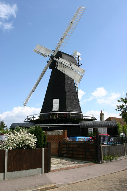
Herne Windmill

Herne Windmill is a Grade I listed smock mill in Herne, Kent, England, that was built in 1789. == History == Herne Windmill was built by John Holman in...

Nearby Amenities

Located within 500m of 51.357669,1.155661
Traffic Calming: table
Lat/Long: 51.3601781/1.1532135
Traffic Calming: table
Lat/Long: 51.3597706/1.1504233
Traffic Calming: table
Lat/Long: 51.3595988/1.1525105
Post Box
Brand: Royal Mail
Brand Wikidata: Q638098
Brand Wikipedia: en:Royal Mail
Collection Times: Mo-Fr 09:00; Sa 07:00
Operator: Royal Mail
Operator Wikidata: Q638098
Post Box Mounting: metal_post
Post Box Type: lamp
Postal Code: CT6
Ref: CT6 110
Royal Cypher: EIIR
Royal Cypher Wikidata: Q33102113
Source: survey
Lat/Long: 51.358334/1.149021
Post Office
Broomfield Post Office
Addr City: Herne Bay
Addr Country: GB
Addr County: Kent
Addr Housenumber: 98
Addr Postcode: CT6 7AG
Addr Street: Margate Road
Brand: Post Office
Brand Wikidata: Q1783168
Collection Times: Mo-Fr 17:15;Sa 11:45
Fhrs Id: 1102888
Opening Hours: Mo-Fr 09:00-17:30; Sa 09:00-12:30
Operator: Post Office
Ref Pol Id: 377
Website: https://www.postoffice.co.uk/branch-finder/0639095/broomfield
Lat/Long: 51.3584665/1.1557035
Pub
Huntsman and Horn
Addr Postcode: CT6 7AF
Addr Street: Margate Road
Addr Village: Herne
Fhrs Id: 1413955
Source Addr: FHRS Open Data
Wikidata: Q26621328
Lat/Long: 51.3574292/1.1573531
Motorway Junction
Lat/Long: 51.3606308/1.1528837
Place Of Worship
Broomfield Methadist Church
Denomination: methodist
Religion: christian
Lat/Long: 51.3583307/1.1510376
Post Box
Brand: Royal Mail
Brand Wikidata: Q638098
Brand Wikipedia: en:Royal Mail
Collection Plate: CP1
Collection Times: Mo-Fr 17:00; Sa 12:30
Operator: Royal Mail
Operator Wikidata: Q638098
Post Box Mounting: wall
Post Box Type: wall
Postal Code: CT6
Ref: CT6 17
Royal Cypher: EIIR
Royal Cypher Wikidata: Q33102113
Lat/Long: 51.3584727/1.1557125
Bus Stop
The Meadows
Naptan AtcoCode: 240097536
Naptan Bearing: E
Naptan CommonName: The Meadows
Naptan Indicator: opp
Naptan Landmark: The Meadows
Naptan NaptanCode: kntjgjmj
Naptan PlusbusZoneRef: HRNEBAY
Naptan Street: Margate Road
Naptan Verified: no
Public Transport: platform
Ref: kntjgjmj
Source: naptan_import
Source Date: 2019-06-12T11:07:00
Lat/Long: 51.358615/1.1501903
Bus Stop
Hoopers Lane
Naptan AtcoCode: 240097538
Naptan Bearing: E
Naptan CommonName: Hoopers Lane
Naptan Indicator: adj
Naptan Landmark: Hoopers Lane
Naptan NaptanCode: kntjgjwp
Naptan PlusbusZoneRef: HRNEBAY
Naptan ShortCommonName: Hoopers Ln
Naptan Street: Margate Road
Naptan Verified: no
Public Transport: platform
Ref: kntjgjwp
Short Name: Hoopers Ln
Source: naptan_import
Source Date: 2015-04-21T08:49:00
Lat/Long: 51.3589183/1.1542912
Bus Stop
Huntsman and Horn
Fixme: Can someone confirm whether or not busses stop here?
Flag: no
Naptan AtcoCode: 240097540
Naptan Bearing: SE
Naptan BusStopType: CUS
Naptan CommonName: Huntsman and Horn
Naptan Indicator: opp
Naptan Landmark: Huntsman and Horn
Naptan NaptanCode: kntjgjwt
Naptan PlusbusZoneRef: HRNEBAY
Naptan Street: Margate Road
Naptan Verified: no
Public Transport: platform
Ref: kntjgjwt
Source: naptan_import
Source Date: 2018-08-21T09:02:00
Lat/Long: 51.3576579/1.1573364
Bus Stop
Huntsman and Horn
Fixme: Can someone confirm whether or not busses stop here?
Flag: no
Naptan AtcoCode: 240097542
Naptan Bearing: NW
Naptan BusStopType: CUS
Naptan CommonName: Huntsman and Horn
Naptan Indicator: adj
Naptan Landmark: Huntsman and Horn PH
Naptan NaptanCode: kntjgjwm
Naptan PlusbusZoneRef: HRNEBAY
Naptan Street: Margate Road
Naptan Verified: no
Public Transport: platform
Ref: kntjgjwm
Source: naptan_import
Source Date: 2018-08-21T09:02:00
Lat/Long: 51.3575345/1.1572418
Bus Stop
Hoopers Lane
Naptan AtcoCode: 2400A041600A
Naptan Bearing: W
Naptan CommonName: Hoopers Lane
Naptan Indicator: opp
Naptan Landmark: Hoopers Lane
Naptan NaptanCode: kntdtdtd
Naptan PlusbusZoneRef: HRNEBAY
Naptan Street: Margate Road
Naptan Verified: no
Public Transport: platform
Ref: kntdtdtd
Source: naptan_import
Source Date: 2018-08-21T08:59:00
Lat/Long: 51.3587769/1.1541953
Bus Stop
The Meadows
Naptan AtcoCode: 2400A041610A
Naptan Bearing: W
Naptan CommonName: The Meadows
Naptan Indicator: adj
Naptan Landmark: The Meadows
Naptan NaptanCode: kntdtdtg
Naptan PlusbusZoneRef: HRNEBAY
Naptan Street: Margate Road
Naptan Verified: no
Public Transport: platform
Ref: kntdtdtg
Source: naptan_import
Source Date: 2019-06-12T11:08:00
Lat/Long: 51.3584254/1.1495452
Bus Stop
Gorse Lane
Naptan AtcoCode: 2400A041690A
Naptan Bearing: NE
Naptan CommonName: Gorse Lane
Naptan Indicator: opp
Naptan Landmark: Gorse Lane
Naptan NaptanCode: kntdtdwj
Naptan PlusbusZoneRef: HRNEBAY
Naptan Street: Hunters Forstal Road
Naptan Verified: no
Public Transport: platform
Ref: kntdtdwj
Source: naptan_import
Source Date: 2019-06-12T11:09:00
Lat/Long: 51.3583178/1.1485321
Traffic Calming: hump
Lat/Long: 51.359671/1.1515411
Traffic Calming: hump
Lat/Long: 51.3595025/1.1497393
Mini Roundabout
Direction: clockwise
Lat/Long: 51.358459/1.1488933
Crossing
Crossing: zebra
Tactile Paving: yes
Lat/Long: 51.3612528/1.1526336
Generator Method: photovoltaic
Generator Orientation: 156
Generator Output Electricity: yes
Generator Source: solar
Generator Type: solar_photovoltaic_panel
Location: roof
Power: generator
Lat/Long: 51.3556781/1.1519471
Generator Method: photovoltaic
Generator Orientation: 191
Generator Output Electricity: yes
Generator Solar Modules: 16
Generator Source: solar
Generator Type: solar_photovoltaic_panel
Location: roof
Power: generator
Lat/Long: 51.3562451/1.1530294
Generator Method: photovoltaic
Generator Orientation: 189
Generator Output Electricity: yes
Generator Solar Modules: 15
Generator Source: solar
Generator Type: solar_photovoltaic_panel
Location: roof
Power: generator
Lat/Long: 51.3578664/1.150665
Generator Method: photovoltaic
Generator Orientation: 269
Generator Output Electricity: yes
Generator Solar Modules: 8
Generator Source: solar
Generator Type: solar_photovoltaic_panel
Location: roof
Power: generator
Lat/Long: 51.3577115/1.151251
Generator Method: photovoltaic
Generator Orientation: 279
Generator Output Electricity: yes
Generator Solar Modules: 5
Generator Source: solar
Generator Type: solar_photovoltaic_panel
Location: roof
Power: generator
Lat/Long: 51.3577325/1.1524742
Generator Method: photovoltaic
Generator Orientation: 99
Generator Output Electricity: yes
Generator Solar Modules: 10
Generator Source: solar
Generator Type: solar_photovoltaic_panel
Location: roof
Power: generator
Lat/Long: 51.3577308/1.1525117
Generator Method: photovoltaic
Generator Orientation: 111
Generator Output Electricity: yes
Generator Solar Modules: 16
Generator Source: solar
Generator Type: solar_photovoltaic_panel
Location: roof
Power: generator
Lat/Long: 51.35765/1.1557846
Generator Method: photovoltaic
Generator Orientation: 173
Generator Output Electricity: yes
Generator Solar Modules: 8
Generator Source: solar
Generator Type: solar_photovoltaic_panel
Location: roof
Power: generator
Lat/Long: 51.3584945/1.1524587
Generator Method: photovoltaic
Generator Orientation: 281
Generator Output Electricity: yes
Generator Solar Modules: 5
Generator Source: solar
Generator Type: solar_photovoltaic_panel
Location: roof
Power: generator
Lat/Long: 51.3592377/1.1557901
Generator Method: photovoltaic
Generator Orientation: 191
Generator Output Electricity: yes
Generator Solar Modules: 11
Generator Source: solar
Generator Type: solar_photovoltaic_panel
Location: roof
Power: generator
Lat/Long: 51.3592068/1.1558457
Generator Method: photovoltaic
Generator Orientation: 290
Generator Output Electricity: yes
Generator Solar Modules: 16
Generator Source: solar
Generator Type: solar_photovoltaic_panel
Location: roof
Power: generator
Lat/Long: 51.3585393/1.1566034
Recycling
Recycling Type: container
Lat/Long: 51.3608732/1.1506865
Generator Method: photovoltaic
Generator Output Electricity: yes
Generator Solar Modules: 7
Generator Source: solar
Generator Type: solar_photovoltaic_panel
Location: roof
Power: generator
Lat/Long: 51.3565771/1.1541994
Generator Method: photovoltaic
Generator Output Electricity: yes
Generator Source: solar
Generator Type: solar_photovoltaic_panel
Location: roof
Power: generator
Lat/Long: 51.3569109/1.1538219
Generator Method: photovoltaic
Generator Output Electricity: yes
Generator Solar Modules: 5
Generator Source: solar
Generator Type: solar_photovoltaic_panel
Location: roof
Power: generator
Lat/Long: 51.3570955/1.1560663
Generator Method: photovoltaic
Generator Output Electricity: yes
Generator Solar Modules: 4
Generator Source: solar
Generator Type: solar_photovoltaic_panel
Location: roof
Power: generator
Lat/Long: 51.3570797/1.156197
Generator Method: photovoltaic
Generator Output Electricity: yes
Generator Solar Modules: 4
Generator Source: solar
Generator Type: solar_photovoltaic_panel
Location: roof
Power: generator
Lat/Long: 51.3570704/1.1562816
Generator Method: photovoltaic
Generator Output Electricity: yes
Generator Solar Modules: 4
Generator Source: solar
Generator Type: solar_photovoltaic_panel
Location: roof
Power: generator
Lat/Long: 51.3570591/1.15637
Generator Method: photovoltaic
Generator Output Electricity: yes
Generator Solar Modules: 4
Generator Source: solar
Generator Type: solar_photovoltaic_panel
Location: roof
Power: generator
Lat/Long: 51.3576612/1.156651
Generator Method: photovoltaic
Generator Output Electricity: yes
Generator Solar Modules: 4
Generator Source: solar
Generator Type: solar_photovoltaic_panel
Location: roof
Power: generator
Lat/Long: 51.3576743/1.1565055
Generator Method: photovoltaic
Generator Output Electricity: yes
Generator Solar Modules: 4
Generator Source: solar
Generator Type: solar_photovoltaic_panel
Location: roof
Power: generator
Lat/Long: 51.3576462/1.1566993
Generator Method: photovoltaic
Generator Output Electricity: yes
Generator Solar Modules: 8
Generator Source: solar
Generator Type: solar_photovoltaic_panel
Location: roof
Power: generator
Lat/Long: 51.359698/1.1539011
Generator Method: photovoltaic
Generator Output Electricity: yes
Generator Source: solar
Generator Type: solar_photovoltaic_panel
Location: roof
Power: generator
Lat/Long: 51.3586474/1.1536845
Generator Method: photovoltaic
Generator Orientation: 96
Generator Output Electricity: yes
Generator Solar Modules: 16
Generator Source: solar
Generator Type: solar_photovoltaic_panel
Location: roof
Power: generator
Lat/Long: 51.3588048/1.1563815
Leisure: playground
Source: OS Open Greenspace
Lat/Long: 51.3574695/1.1551255
Generator Method: photovoltaic
Generator Orientation: 173
Generator Output Electricity: yes
Generator Solar Modules: 8
Generator Source: solar
Generator Type: solar_photovoltaic_panel
Location: roof
Power: generator
Lat/Long: 51.3584874/1.1523689
Childcare
Goldfinch Nursery
Lat/Long: 51.3557573/1.1585055
The data included in this document is from www.openstreetmap.org. The data is made available under ODbL.

Have you been to Broomfield?

Leave your review of Broomfield below (or comments, questions and feedback).