Long Marton

Civil Parish in Westmorland Eden

England

Long Marton

Stamp Hill Farm Viewed from a passing train. The yard in the foreground appears to have been surfaced since an earlier photo <a href="https://www.geograph.org.uk/photo/3820658">NY6526 : Stamp Hill Farm</a>.
Stamp Hill Farm Credit: Stephen Craven

Long Marton is a civil parish located in the district of Eden, in the county of Cumbria, England. It is situated in the historic region of Westmorland, which was merged into the larger county of Cumbria in 1974.

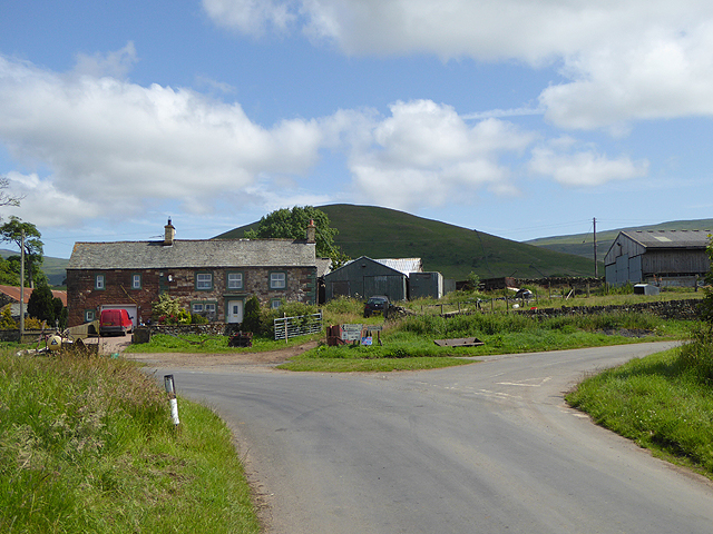
The village of Long Marton is nestled in the picturesque Eden Valley, surrounded by rolling hills and farmland. It is approximately 10 miles northeast of the town of Appleby-in-Westmorland and 13 miles southeast of Penrith. The parish covers an area of about 9 square miles and has a population of around 500 people.

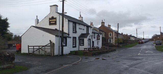
Long Marton is known for its charming rural character and traditional stone-built houses. The village has a beautiful church, St. Mary's, which dates back to the 12th century and is a Grade II listed building. There is also a primary school, a village hall, and a pub, providing essential amenities for the local community.

The area is popular with walkers and nature enthusiasts due to its scenic countryside and proximity to the Pennines and the North Pennines Area of Outstanding Natural Beauty. The River Eden flows nearby, offering opportunities for fishing and boating.

Long Marton has a strong sense of community, with various social and cultural events taking place throughout the year. The village also benefits from its close proximity to larger towns, providing access to further amenities and services.

If you have any feedback on the listing, please let us know in the comments section below.

Long Marton Images

Images are sourced within 2km of 54.619617/-2.518933 or Grid Reference NY6625. Thanks to Geograph Open Source API. All images are credited.

Stamp Hill Farm Viewed from a passing train. The yard in the foreground appears to have been surfaced since an earlier photo <a href="https://www.geograph.org.uk/photo/3820658">NY6526 : Stamp Hill Farm</a>.
Stamp Hill Farm
Viewed from a passing train. The yard in the foreground appears to have been surfaced since an earlier photo NY6526 : Stamp Hill Farm.
The Masons Arms, Long Marton The Masons Arms, Long Marton, a public house and restaurant.
The Masons Arms, Long Marton
The Masons Arms, Long Marton, a public house and restaurant.
Minor road towards Long Marton
Road junction near Brampton
Benchmark, Long Marton, Bridge 253 Detail of an Ordnance Survey cut benchmark on the end pier of the south east abutment of Park Lane Bridge on the Settle to Carlisle railway, railway engineers’ bridge reference number SAC/253.  The benchmark marks a height of 132.4021m above mean sea level (Ordnance Datum Newlyn) last verified in 1955.
Benchmark, Long Marton, Bridge 253
Detail of an Ordnance Survey cut benchmark on the end pier of the south east abutment of Park Lane Bridge on the Settle to Carlisle railway, railway engineers’ bridge reference number SAC/253. The benchmark marks a height of 132.4021m above mean sea level (Ordnance Datum Newlyn) last verified in 1955.
Ordnance Survey Cut Mark This OS cut mark can be found on the gatepost south side of the road.
Ordnance Survey Cut Mark
This OS cut mark can be found on the gatepost south side of the road.
Ordnance Survey Cut Mark This OS cut mark can be found on the gatepost NW side of the road. It marks a point 165.314m above mean sea level.
Ordnance Survey Cut Mark
This OS cut mark can be found on the gatepost NW side of the road. It marks a point 165.314m above mean sea level.
Ordnance Survey Cut Mark This OS cut mark can be found on the outbuilding at Park House. It marks a point 125.605m above mean sea level.
Ordnance Survey Cut Mark
This OS cut mark can be found on the outbuilding at Park House. It marks a point 125.605m above mean sea level.
Ordnance Survey Cut Mark This damaged OS cut mark can be found on the north parapet of the bridge. It marked a point 123.819m above mean sea level.
Ordnance Survey Cut Mark
This damaged OS cut mark can be found on the north parapet of the bridge. It marked a point 123.819m above mean sea level.
Ordnance Survey Cut Mark This OS cut mark can be found on the SE abutment of the railway bridge. It marks a point 132.402m above mean sea level.
Ordnance Survey Cut Mark
This OS cut mark can be found on the SE abutment of the railway bridge. It marks a point 132.402m above mean sea level.
Ordnance Survey Cut Mark This OS cut mark can be found on the SE side of the railway bridge. It marks a point 134.612m above mean sea level.
Ordnance Survey Cut Mark
This OS cut mark can be found on the SE side of the railway bridge. It marks a point 134.612m above mean sea level.
Ordnance Survey Cut Mark This OS cut mark can be found on the NE side of the railway bridge. It marks a point 134.615m above mean sea level.
Ordnance Survey Cut Mark
This OS cut mark can be found on the NE side of the railway bridge. It marks a point 134.615m above mean sea level.
Ordnance Survey Cut Mark This OS cut mark can be found on the SW angle of the Church of St Margaret & St James. It marks a point 128.446m above mean sea level.
Ordnance Survey Cut Mark
This OS cut mark can be found on the SW angle of the Church of St Margaret & St James. It marks a point 128.446m above mean sea level.
Ordnance Survey Cut Mark This OS cut mark can be found on the NW side of the railway bridge. It marks a point 138.647m above mean sea level.
Ordnance Survey Cut Mark
This OS cut mark can be found on the NW side of the railway bridge. It marks a point 138.647m above mean sea level.
Ordnance Survey Cut Mark This OS cut mark can be found on the gatepost south side of the road. It marks a point 141.753m above mean sea level.
Ordnance Survey Cut Mark
This OS cut mark can be found on the gatepost south side of the road. It marks a point 141.753m above mean sea level.
Ordnance Survey Rivet This OS rivet can be found on the SE parapet of the railway bridge. It marks a point 144.664m above mean sea level.
Ordnance Survey Rivet
This OS rivet can be found on the SE parapet of the railway bridge. It marks a point 144.664m above mean sea level.
Ordnance Survey Cut Mark This OS cut mark can be found on the gatepost east side of the road. It marks a point 159.523m above mean sea level.
Ordnance Survey Cut Mark
This OS cut mark can be found on the gatepost east side of the road. It marks a point 159.523m above mean sea level.
Show me another place!

Long Marton is located at Grid Ref: NY6625 (Lat: 54.619617, Lng: -2.518933)

Administrative County: Cumbria

District: Eden

Police Authority: Cumbria

What 3 Words

///suffer.innocence.blizzard. Near Appleby-in-Westmorland, Cumbria

Nearby Locations

Long Marton

Related Wikis

Long Marton railway station

Long Marton railway station was a railway station which served the village of Long Marton in Cumbria, England. Situated on the Settle-Carlisle Line, it...

Long Marton

Long Marton is a village and civil parish in the Eden District of the English county of Cumbria. In 2011 the population was 827. The village previously...

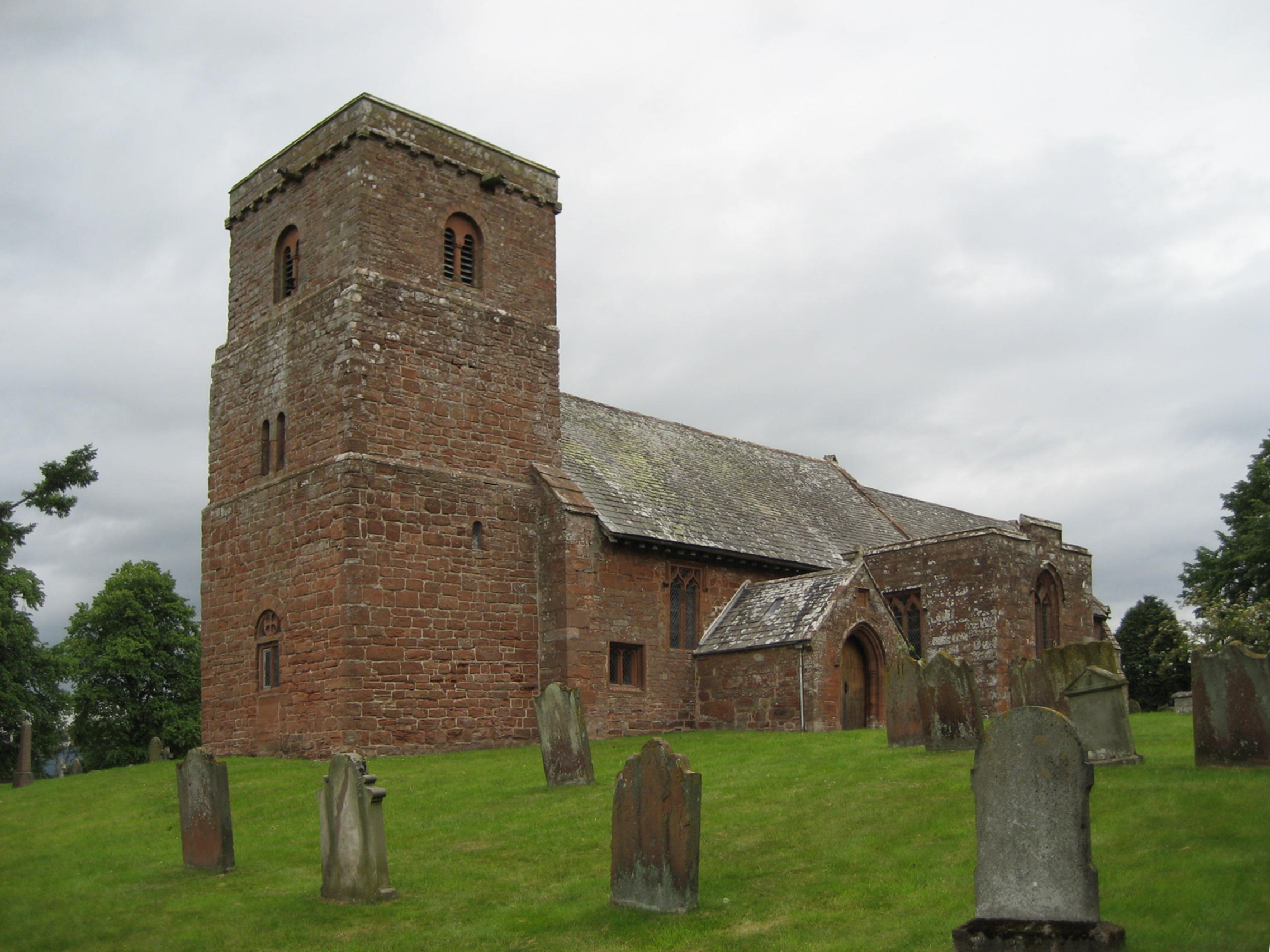
St Margaret and St James' Church, Long Marton

St Margaret and St James' Church is located about 0.5 miles (0.8 km) to the south of the village of Long Marton, Cumbria, England. It is an active Anglican...

Broom, Cumbria

Broom is a hamlet near the village of Long Marton, in the Eden district, in the county of Cumbria, England. == Location == It is located about two miles...

Brampton, Eden

Brampton is a village in the Eden district, in the county of Cumbria, England. Before 1974 it was in the county of Westmorland; the nearest town is Appleby...

St Cuthbert's Church, Dufton

St Cuthbert's Church is situated 3⁄4 mile (1.2 km) north of the village of Dufton, Cumbria, England. It should not be confused with the nearby St Cuthbert...

Dufton

Dufton is a village and civil parish in Cumbria, England. Historically part of Westmorland, it lies in the Eden Valley and below Great Dun Fell. It is...

Knock, Cumbria

Knock is a small village in the Eden district of Cumbria, England, and 1.9 km northwest of the larger village of Dufton and 3.1 km south of the village...

Nearby Amenities

Located within 500m of 54.619617,-2.518933
Turning Circle
Lat/Long: 54.6168146/-2.5191757
Note: FIXME - way continues; survey required
Lat/Long: 54.617371/-2.5192722
Telephone
Booth: K6
Check Date: 2021-09-10
Covered: booth
Listed Status: Grade II
Source: survey
Lat/Long: 54.6156508/-2.5180487
Long Marton
Historic Railway: station
Railway: site
Wikidata: Q6672979
Wikipedia: en:Long Marton railway station
Lat/Long: 54.6171761/-2.5188847
Power: pole
Lat/Long: 54.6224645/-2.5182674
Power: pole
Lat/Long: 54.6215215/-2.5180283
Power: pole
Lat/Long: 54.6233213/-2.5185031
Power: pole
Lat/Long: 54.6211704/-2.5191274
Barrier: yes
Lat/Long: 54.6194566/-2.5194076
Barrier: yes
Lat/Long: 54.6167129/-2.5176417
Power: pole
Lat/Long: 54.6156922/-2.5158245
The data included in this document is from www.openstreetmap.org. The data is made available under ODbL.

Have you been to Long Marton?

Leave your review of Long Marton below (or comments, questions and feedback).