Horsham St. Faith and Newton St. Faith

Civil Parish in Norfolk Broadland

England

Horsham St. Faith and Newton St. Faith

OS Benchmark Recorded on Benchmark Database as 'Spixworth, St Peter's Church'.
OS Benchmark Credit: David Bremner

Horsham St. Faith and Newton St. Faith are two civil parishes located in the county of Norfolk, England. These parishes are situated approximately 7 miles north of Norwich, the county town.

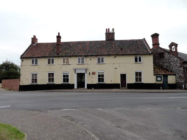
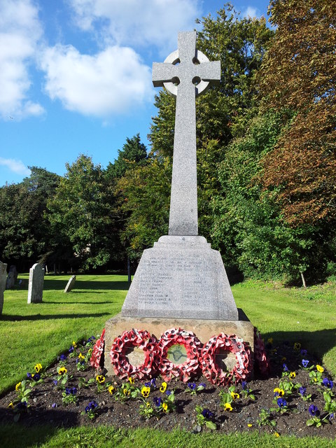
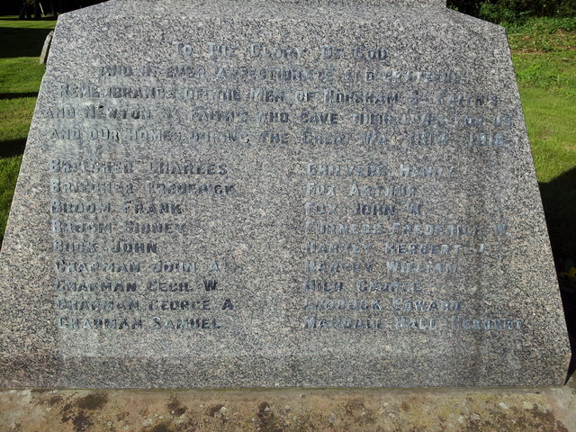
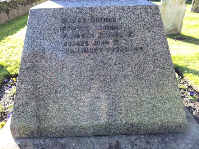
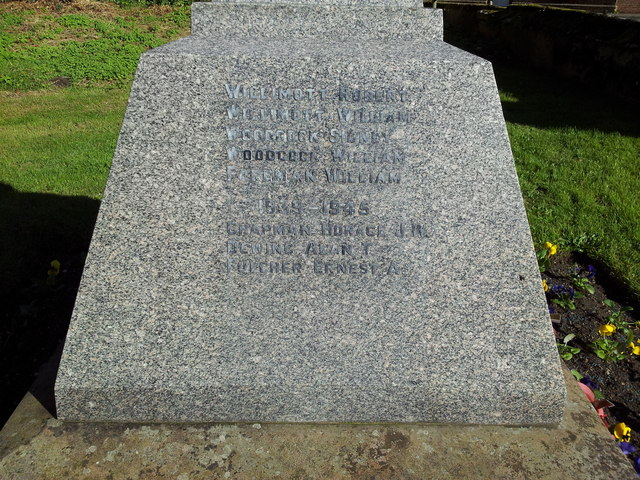
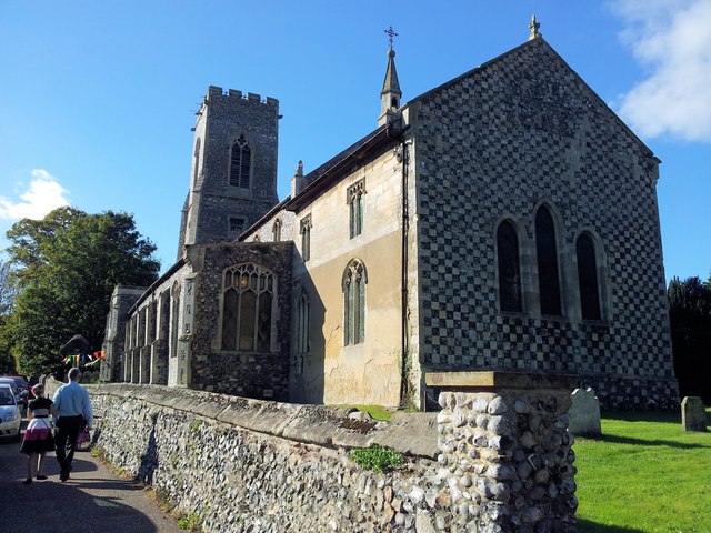
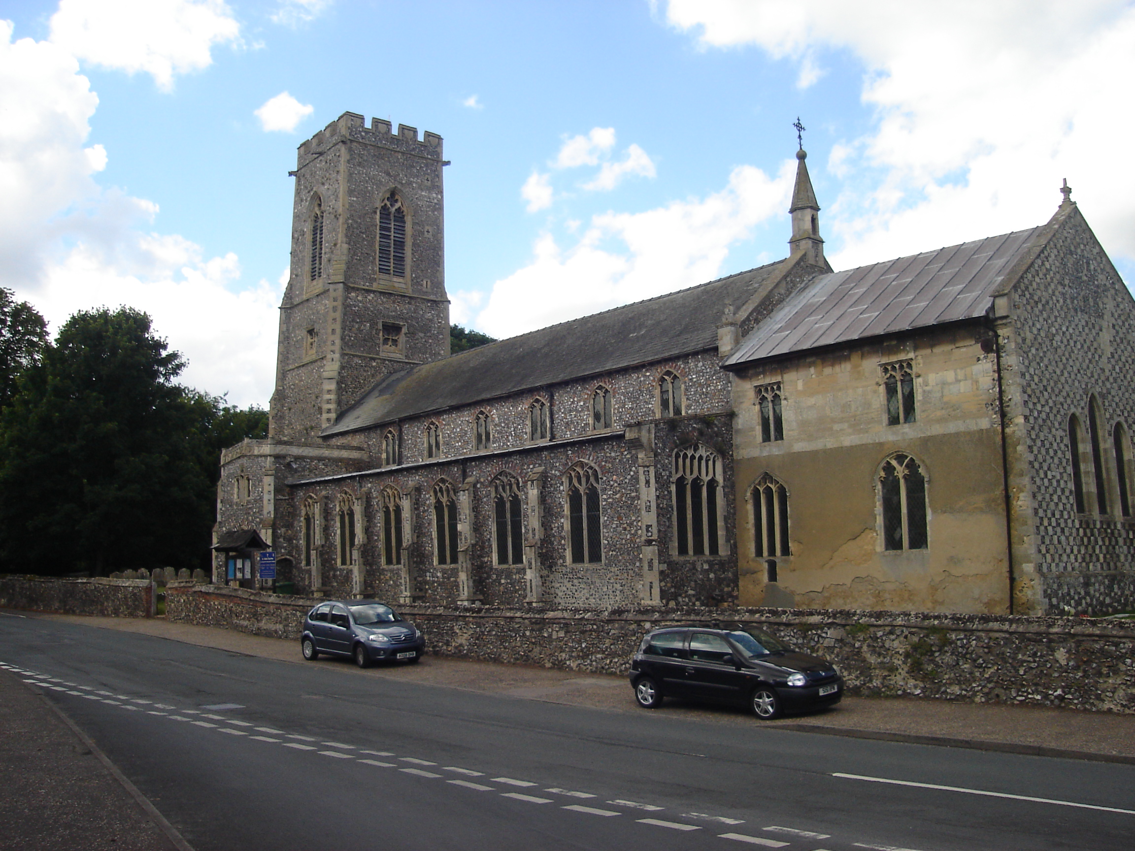
Horsham St. Faith is a small village with a population of around 1,000 residents. It has a rich history dating back to the Roman period, evidenced by the discovery of Roman coins and pottery fragments in the area. The village is known for its beautiful St. Mary and St. Andrew Church, which dates back to the 12th century and features stunning architectural details. The village also has a primary school, a village hall, and a few local businesses.

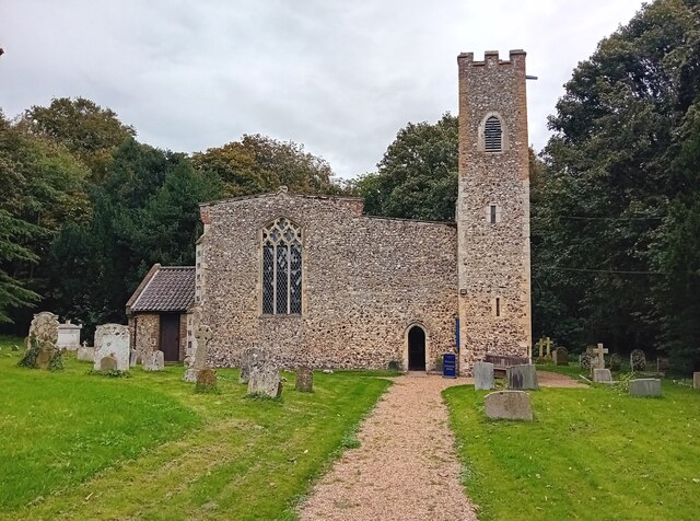
Newton St. Faith, on the other hand, is a much smaller parish with a population of approximately 300. It is adjacent to Horsham St. Faith and is often considered a part of the same community. The parish is largely rural, with picturesque countryside views and a peaceful atmosphere. It is home to St. Faith's Church, a charming medieval building that adds to the area's historical charm.

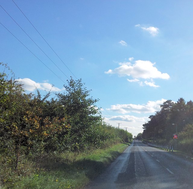
Both parishes benefit from their proximity to Norwich, which provides easy access to various amenities, employment opportunities, and cultural attractions. The area is well connected by road, with the A140 passing nearby, and public transportation options are available for commuting to Norwich and other nearby towns.

Overall, Horsham St. Faith and Newton St. Faith offer a tranquil and scenic living environment with a strong sense of history and community.

If you have any feedback on the listing, please let us know in the comments section below.

Horsham St. Faith and Newton St. Faith Images

Images are sourced within 2km of 52.693754/1.286142 or Grid Reference TG2215. Thanks to Geograph Open Source API. All images are credited.

OS Benchmark Recorded on Benchmark Database as 'Spixworth, St Peter's Church'.
OS Benchmark
Recorded on Benchmark Database as 'Spixworth, St Peter's Church'.
St Peter's, Spixworth An attractive church which we were delighted to find open.
St Peter's, Spixworth
An attractive church which we were delighted to find open.
Flowers, St Peter's Church Attractive floral display at St Peter's Church, Spixworth.
Flowers, St Peter's Church
Attractive floral display at St Peter's Church, Spixworth.
Norwich Airport control tower
Norwich Aviation Museum
The Kings Head Public House Horsham St Faith Now closed and a private residence
The Kings Head Public House Horsham St Faith
Now closed and a private residence
Ford and Rider at Horsham St Faith This ford is found at Horsham St Faith very close to Norwich International Airport
Ford and Rider at Horsham St Faith
This ford is found at Horsham St Faith very close to Norwich International Airport
Entrance to Petans Training Centre
Entrance to Aviation Museum
Spixworth Road at the junction with Calf Lane
War memorial in the grounds of the Church of St Mary and St Andrew
Names of the Fallen on Horsham St Faith War Memorial 1 Close up of <a href="https://www.geograph.org.uk/photo/3175544">TG2115 : War memorial in the grounds of the Church of St Mary and St Andrew</a>
Names of the Fallen on Horsham St Faith War Memorial 1
Names of the Fallen on Horsham St Faith War Memorial 2 Close up of <a href="https://www.geograph.org.uk/photo/3175544">TG2115 : War memorial in the grounds of the Church of St Mary and St Andrew</a>
Names of the Fallen on Horsham St Faith War Memorial 2
Names of the Fallen on Horsham St Faith War Memorial 3 Close up of <a href="https://www.geograph.org.uk/photo/3175544">TG2115 : War memorial in the grounds of the Church of St Mary and St Andrew</a>
Names of the Fallen on Horsham St Faith War Memorial 3
Church of St Mary and St Andrew, Horsham St Faith
Manor Road approaching the crematorium
The City of Norwich Aviation Museum (CNAM) Depicted here is a Gloster Meteor F.8 built in 1952. The aircraft, which has the number WK654, served with the All Weather Flying Squadron, Central Fighter Establishment, at RAF West Raynham. The control tower seen in the background is situated on Norwich International Airport.

The City of Norwich Aviation Museum (CNAM) was initially a project of a group of aviation enthusiasts associated with the Eastern Counties Omnibus Company in 1977.  Membership was later opened to non-employees and by 1982 the museum had moved to its present site at Norwich International Airport > <a title="https://www.geograph.org.uk/photo/3175537" href="https://www.geograph.org.uk/photo/3175537">Link</a>. The museum houses a great number of exhibits, including Boulton & Paul who were involved in the manufacture of aircraft from 1914 until 1961; RAF Bomber, Fighter and Coastal Command and the "special duties" RAF 100 Group; RAF Coltishall (closed a few years ago); the United States Army Air Forces'  (USAAF) Eighth Air Force; Women in Aviation; WW1, and of course aircraft, uniforms, and many others.  <span class="nowrap"><a title="http://www.cnam.co.uk/index.php" rel="nofollow ugc noopener" href="http://www.cnam.co.uk/index.php">Link</a><img style="margin-left:2px;" alt="External link" title="External link - shift click to open in new window" src="https://s1.geograph.org.uk/img/external.png" width="10" height="10"/></span>
The City of Norwich Aviation Museum (CNAM)
Depicted here is a Gloster Meteor F.8 built in 1952. The aircraft, which has the number WK654, served with the All Weather Flying Squadron, Central Fighter Establishment, at RAF West Raynham. The control tower seen in the background is situated on Norwich International Airport. The City of Norwich Aviation Museum (CNAM) was initially a project of a group of aviation enthusiasts associated with the Eastern Counties Omnibus Company in 1977. Membership was later opened to non-employees and by 1982 the museum had moved to its present site at Norwich International Airport > Link. The museum houses a great number of exhibits, including Boulton & Paul who were involved in the manufacture of aircraft from 1914 until 1961; RAF Bomber, Fighter and Coastal Command and the "special duties" RAF 100 Group; RAF Coltishall (closed a few years ago); the United States Army Air Forces' (USAAF) Eighth Air Force; Women in Aviation; WW1, and of course aircraft, uniforms, and many others. LinkExternal link
The City of Norwich Aviation Museum (CNAM) This Handley Page Herald (Serial G-ASKK) first flew in July 1962. After several changes of ownership the aircraft was sold to British Midland Airways in February 1965. It took its last flight on 30 March 1985 from Southampton to Norwich and was sold to CNAM for the sum of £1.

The City of Norwich Aviation Museum (CNAM) was initially a project of a group of aviation enthusiasts associated with the Eastern Counties Omnibus Company in 1977.  Membership was later opened to non-employees and by 1982 the museum had moved to its present site at Norwich International Airport > <a title="https://www.geograph.org.uk/photo/3175537" href="https://www.geograph.org.uk/photo/3175537">Link</a>. The museum houses a great number of exhibits, including Boulton & Paul who were involved in the manufacture of aircraft from 1914 until 1961; RAF Bomber, Fighter and Coastal Command and the "special duties" RAF 100 Group; RAF Coltishall (closed a few years ago); the United States Army Air Forces'  (USAAF) Eighth Air Force; Women in Aviation; WW1, and of course aircraft, uniforms, and many others.  <span class="nowrap"><a title="http://www.cnam.co.uk/index.php" rel="nofollow ugc noopener" href="http://www.cnam.co.uk/index.php">Link</a><img style="margin-left:2px;" alt="External link" title="External link - shift click to open in new window" src="https://s1.geograph.org.uk/img/external.png" width="10" height="10"/></span>
The City of Norwich Aviation Museum (CNAM)
This Handley Page Herald (Serial G-ASKK) first flew in July 1962. After several changes of ownership the aircraft was sold to British Midland Airways in February 1965. It took its last flight on 30 March 1985 from Southampton to Norwich and was sold to CNAM for the sum of £1. The City of Norwich Aviation Museum (CNAM) was initially a project of a group of aviation enthusiasts associated with the Eastern Counties Omnibus Company in 1977. Membership was later opened to non-employees and by 1982 the museum had moved to its present site at Norwich International Airport > Link. The museum houses a great number of exhibits, including Boulton & Paul who were involved in the manufacture of aircraft from 1914 until 1961; RAF Bomber, Fighter and Coastal Command and the "special duties" RAF 100 Group; RAF Coltishall (closed a few years ago); the United States Army Air Forces' (USAAF) Eighth Air Force; Women in Aviation; WW1, and of course aircraft, uniforms, and many others. LinkExternal link
Show me another place!

Horsham St. Faith and Newton St. Faith is located at Grid Ref: TG2215 (Lat: 52.693754, Lng: 1.286142)

Administrative County: Norfolk

District: Broadland

Police Authority: Norfolk

What 3 Words

///booth.boxing.fever. Near Spixworth, Norfolk

Related Wikis

Horsham St Faith

Horsham St Faith is a village in Norfolk, England. The village lies close and to the east of the A140 road and is 5 miles (8.0 km) north of Norwich and...

Horsham St Faith and Newton St Faith

Horsham St Faith and Newton St Faith is a civil parish in the English county of Norfolk, consisting of the former parishes of Horsham St Faith and Newton...

City of Norwich Aviation Museum

The City of Norwich Aviation Museum is a volunteer-run museum and charitable trust dedicated to the preservation of the aviation history of the county...

Horsford Castle

Horsford Castle is situated in the village of Horsford, 6 miles to the north of the city of Norwich. == Details == Before the Norman conquest of England...

Nearby Amenities

Located within 500m of 52.693754,1.286142
Bus Stop
Black Swan, adj
Bench: yes
Naptan AtcoCode: 2900H471
Naptan Bearing: SW
Naptan CommonName: Black Swan
Naptan Indicator: adj
Naptan Landmark: Black Swan
Naptan Locality: Horsham St Faith
Naptan NaptanCode: nfoawtdg
Naptan PlusbusZoneRef: NRCH
Naptan Street: Norwich Road
Naptan Verified: no
Shelter: yes
Source: naptan_import
Tactile Paving: yes
Lat/Long: 52.6907109/1.2819391
Bus Stop
Crematorium, opp
Alt Name: St Faiths Crematorium
Naptan AltCommonName: St Faiths Crematorium
Naptan AtcoCode: 2900H4712
Naptan Bearing: S
Naptan CommonName: Crematorium
Naptan Indicator: opp
Naptan Landmark: Crematorium Bus Shelter
Naptan Locality: Horsham St Faith
Naptan NaptanCode: nfoawtdp
Naptan PlusbusZoneRef: NRCH
Naptan Street: Manor Road
Naptan Verified: no
Shelter: yes
Source: naptan_import
Lat/Long: 52.695071/1.2831469
Bus Stop
Crematorium, adj
Naptan AtcoCode: 2900H4713
Naptan Bearing: N
Naptan CommonName: Crematorium
Naptan Indicator: adj
Naptan Landmark: Crematorium
Naptan Locality: Horsham St Faith
Naptan NaptanCode: nfoawtdt
Naptan PlusbusZoneRef: NRCH
Naptan Street: Manor Road
Naptan Verified: no
Shelter: no
Source: naptan_import
Lat/Long: 52.6953069/1.2829059
The Beck
Access: no
Ford: yes
Horse: yes
Motor Vehicle: yes
Seasonal: no
Lat/Long: 52.6930578/1.2832487
Barrier: cycle_barrier
Lat/Long: 52.694622/1.2822275
Fountain
Lat/Long: 52.696859/1.2808057
Bench
Backrest: yes
Lat/Long: 52.6946797/1.2829686
Bench
Backrest: yes
Lat/Long: 52.694704/1.2829666
Bench
Backrest: yes
Check Date: 2020-12-29
Colour: green
Lat/Long: 52.6898518/1.2850214
Bench
Backrest: yes
Lat/Long: 52.690746/1.2822616
Bench
Backrest: yes
Lat/Long: 52.6908598/1.2821595
Give Way
Lat/Long: 52.6897763/1.2850016
Give Way
Lat/Long: 52.6897487/1.2849378
Material: wood
Power: pole
Lat/Long: 52.6972283/1.2829489
Location Transition: yes
Material: wood
Power: pole
Lat/Long: 52.6945998/1.2832466
Material: wood
Power: pole
Lat/Long: 52.6955012/1.28315
Crossing
Lat/Long: 52.6959098/1.2828413
Material: wood
Power: pole
Lat/Long: 52.6961132/1.2830682
Waste Basket
Waste: dog_excrement
Lat/Long: 52.6919649/1.2850117
Waste Basket
Waste: dog_excrement
Lat/Long: 52.6938511/1.2830847
Waste Basket
Waste: dog_excrement
Lat/Long: 52.6898192/1.285214
Waste Basket
Colour: green
Material: plastic
Lat/Long: 52.6898075/1.2852232
Waste Basket
Colour: green
Material: plastic
Waste: trash
Lat/Long: 52.6950529/1.2831501
Access: no
Barrier: bollard
Bicycle: yes
Bollard: fixed
Foot: yes
Height: 0.75
Horse: no
Material: concrete
Motor Vehicle: no
Lat/Long: 52.6930236/1.2830122
Access: private
Barrier: swing_gate
Material: metal
Lat/Long: 52.691262/1.2871359
Leisure: picnic_table
Lat/Long: 52.6895989/1.2854056
Ford: yes
Lat/Long: 52.6977163/1.2827299
Crossing
Lat/Long: 52.6971399/1.2827912
Crossing
Lat/Long: 52.6964395/1.282867
Crossing
Crossing: unmarked
Lat/Long: 52.6915774/1.2822455
Crossing
Crossing: unmarked
Lat/Long: 52.6918549/1.2822862
Crossing
Crossing: unmarked
Tactile Paving: no
Lat/Long: 52.6919783/1.2823043
Crossing
Crossing: unmarked
Tactile Paving: no
Lat/Long: 52.6923311/1.282372
Ford: yes
Lat/Long: 52.6930951/1.2828333
The data included in this document is from www.openstreetmap.org. The data is made available under ODbL.

Have you been to Horsham St. Faith and Newton St. Faith?

Leave your review of Horsham St. Faith and Newton St. Faith below (or comments, questions and feedback).