Broneirion

Settlement in Montgomeryshire

Wales

Broneirion

Field near Llandinam
Field near Llandinam Credit: Steven Brown

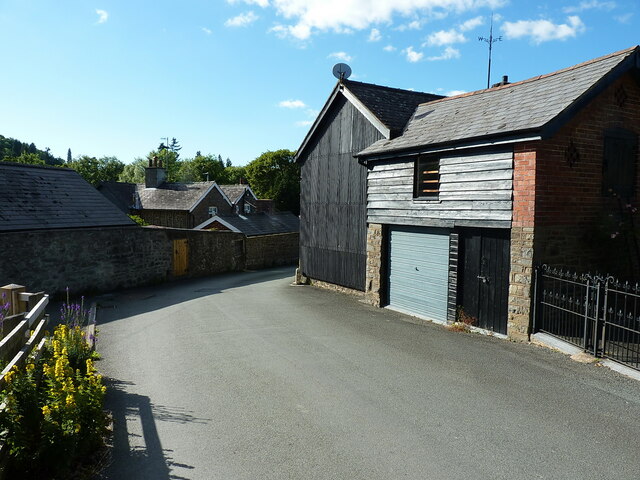
Broneirion is a historic country house located in Montgomeryshire, Wales. Situated on the banks of the River Severn, it is surrounded by picturesque gardens and offers stunning views of the surrounding countryside. The house dates back to the late 19th century and was designed in the Victorian Gothic style by renowned architect George Devey.

The estate spans over 60 acres and includes a mix of woodlands, meadows, and formal gardens. It is well-known for its beautiful rhododendrons and azaleas that bloom in vibrant colors during the spring season. The gardens also feature a charming walled garden, a sunken rose garden, and a tranquil water garden, all of which add to the estate's allure.

Broneirion is often used as a residential conference and events center, accommodating groups for various purposes such as corporate meetings, weddings, and retreats. The house offers comfortable accommodations, including spacious bedrooms and elegant reception rooms. The estate's serene atmosphere and natural surroundings make it a popular choice for those seeking a peaceful and picturesque setting.

In addition to its stunning natural beauty, Broneirion holds historical significance. During World War II, it served as a convalescent home for wounded soldiers. Today, it is owned and managed by Girlguiding Cymru, the national guiding organization for Wales, and is used as a training and activity center for Girlguiding members.

Overall, Broneirion's combination of history, natural beauty, and peaceful ambiance make it a beloved destination for visitors and an important asset to the local community.

If you have any feedback on the listing, please let us know in the comments section below.

Broneirion Images

Images are sourced within 2km of 52.481093/-3.4444655 or Grid Reference SO0288. Thanks to Geograph Open Source API. All images are credited.

Field near Llandinam
Gate at Lower Cwm-ffrwyd The gate blocks the lane up to Wae-llwydion and a number of other small-holdings and farms in the cwm below Bryn Gwyn
Gate at Lower Cwm-ffrwyd
The gate blocks the lane up to Wae-llwydion and a number of other small-holdings and farms in the cwm below Bryn Gwyn
Llandinam village - just east of the main road
Llandinam Institute and hall Built around 1905-1910, and consisting of a library and meeting rooms, the Institute was Grade II listed in 1996. It is noted for illustrating the beneficence of the local Davies family of Plâs Dinam towards their village, the house being half a mile or so further north.
Llandinam Institute and hall
Built around 1905-1910, and consisting of a library and meeting rooms, the Institute was Grade II listed in 1996. It is noted for illustrating the beneficence of the local Davies family of Plâs Dinam towards their village, the house being half a mile or so further north.
OS Flush Bracket 11673 - Llandinam Found on the roadside wall just north of <a href="https://www.geograph.org.uk/photo/2987313">SO0288 : The Lion Hotel - Llandinam</a> (which is currently closed and awaiting new ownership in 2022), the flush bracket was last levelled in 1971 at 137.023m above Ordnance Datum Newlyn.
OS Flush Bracket 11673 - Llandinam
Found on the roadside wall just north of SO0288 : The Lion Hotel - Llandinam (which is currently closed and awaiting new ownership in 2022), the flush bracket was last levelled in 1971 at 137.023m above Ordnance Datum Newlyn.
Llandinam Bridge Built in 1846 to the design of the Montgomeryshire County Surveyor Thomas Penson, but very much in the style of a number of cast iron bridges by the famous engineer Thomas Telford. It was cast at an ironworks at Hawarden in North Wales, which had bought some of Telford's castings by that stage. It was Grade II* listed <span class="nowrap"><a title="https://britishlistedbuildings.co.uk/300015653-llandinam-bridge-llandinam#.Yt11OnbMLIU" rel="nofollow ugc noopener" href="https://britishlistedbuildings.co.uk/300015653-llandinam-bridge-llandinam#.Yt11OnbMLIU">Link</a><img style="margin-left:2px;" alt="External link" title="External link - shift click to open in new window" src="https://s1.geograph.org.uk/img/external.png" width="10" height="10"/></span> in 1994. The railings at the western end still have the <a href="https://www.geograph.org.uk/photo/7236920">SO0288 : Council axle weight restriction on Llandinam Bridge</a> sign dated 1906, limiting motor cars to 3 tons per axle.
Llandinam Bridge
Built in 1846 to the design of the Montgomeryshire County Surveyor Thomas Penson, but very much in the style of a number of cast iron bridges by the famous engineer Thomas Telford. It was cast at an ironworks at Hawarden in North Wales, which had bought some of Telford's castings by that stage. It was Grade II* listed LinkExternal link in 1994. The railings at the western end still have the SO0288 : Council axle weight restriction on Llandinam Bridge sign dated 1906, limiting motor cars to 3 tons per axle.
Council axle weight restriction on Llandinam Bridge Dated 1906 by Montgomeryshire CC, the cast iron sign states that "This bridge is insufficient[ly strong] to carry heavy motor cars" where the registered axle weight of any axle exceeds three tons. It forms part of the bridge's Grade II* listing <span class="nowrap"><a title="https://britishlistedbuildings.co.uk/300015653-llandinam-bridge-llandinam#.Yt14XnbMLIU" rel="nofollow ugc noopener" href="https://britishlistedbuildings.co.uk/300015653-llandinam-bridge-llandinam#.Yt14XnbMLIU">Link</a><img style="margin-left:2px;" alt="External link" title="External link - shift click to open in new window" src="https://s1.geograph.org.uk/img/external.png" width="10" height="10"/></span>
Council axle weight restriction on Llandinam Bridge
Dated 1906 by Montgomeryshire CC, the cast iron sign states that "This bridge is insufficient[ly strong] to carry heavy motor cars" where the registered axle weight of any axle exceeds three tons. It forms part of the bridge's Grade II* listing LinkExternal link
A470 near Plas Dinam Country House
A470 at Llandinam village
A470 at Tyncoed
A470 at Tyncoed
A470 approaching Pen-rhuddlan Bridge
Trees lining A470 north of Pen-rhuddlan Bridge
Pwllan Cottages on A470
Woodland by A470 south of Tyncoed
A470 and the chapel at Llandinam
David Davies statue, Llandinam A description of the man and his achievements is at <a href="https://www.geograph.org.uk/photo/1389130">SO0288 : David Davies statue beside the A470</a>
David Davies statue, Llandinam
A description of the man and his achievements is at SO0288 : David Davies statue beside the A470
A470 north of Llandinam
War memorial at Llandinam
Show me another place!

Broneirion is located at Grid Ref: SO0288 (Lat: 52.481093, Lng: -3.4444655)

Unitary Authority: Powys

Police Authority: Dyfed Powys

What 3 Words

///thinnest.observes.agent. Near Mochdre, Powys

Nearby Locations

Broneirion

Related Wikis

Llandinam railway station

Llandinam railway station was a station serving Llandinam, Powys, on the Llanidloes and Newtown Railway (L&NR) line. The L&NR was authorised in August...

Penystrywad

Penystrywad is a village near Llandinam in Powys, central Wales, between Newtown and Llanidloes, located on the A470.

Llandinam

Llandinam () is a village and community in Montgomeryshire, Powys, central Wales, between Newtown and Llanidloes, located on the A470. As a community,...
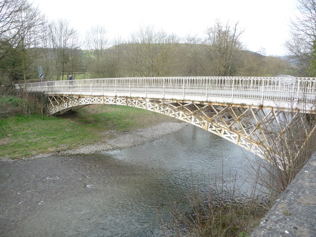
Llandinam Bridge

Llandinam Bridge (Welsh: Pont Llandinam) is a single-arch cast-iron Grade II*-listed bridge located in Llandinam, Powys, Wales. Constructed in 1846, it...

Nearby Amenities

Located within 500m of 52.481093,-3.4444655
Building: yes
Lat/Long: 52.4798457/-3.4423245
Parking
Lat/Long: 52.4784828/-3.4422911
Leisure: picnic_table
Lat/Long: 52.478435/-3.4424214
The data included in this document is from www.openstreetmap.org. The data is made available under ODbL.

Have you been to Broneirion?

Leave your review of Broneirion below (or comments, questions and feedback).