Haconby

Civil Parish in Lincolnshire South Kesteven

England

Haconby

All Saints' church, Dunsby, Lincs. All Saints has a Decorated tower and Early English nave. In a niche is a 15th century figure of Christ and there's a good, octagonal Perpendicular font.
All Saints' church, Dunsby, Lincs. Credit: Richard Croft

Haconby is a small civil parish located in the South Kesteven district of Lincolnshire, England. Situated in the East Midlands region, it lies about six miles east of the market town of Bourne. The parish covers an area of approximately 1,100 acres and is bordered by the parishes of Thurlby, Dunsby, Morton, and Kirkby Underwood.

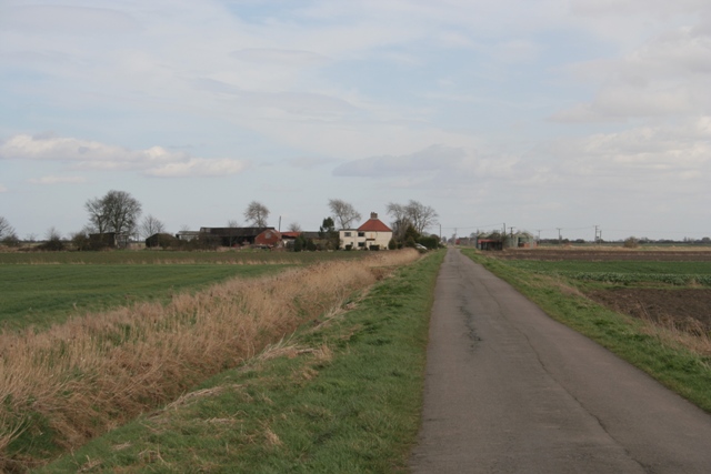
Haconby is a rural village with a population of around 200 residents. It is characterized by its picturesque countryside, rolling hills, and quaint charm. The landscape is predominantly agricultural, with fields and farmland surrounding the village. The River Glen flows to the east of the parish, adding to the natural beauty of the area.

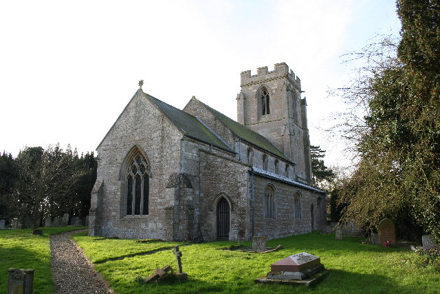
The village itself consists of a cluster of houses, a church, and a pub. St. Andrew's Church, built in the 12th century, is a notable landmark and an important historical site in Haconby. The pub, named The Hare and Hounds, is a popular gathering place for locals and visitors alike.

Haconby is known for its strong sense of community and friendly atmosphere. The village hosts various social events and activities, including a summer fete and a Christmas market. It also has a primary school, which serves the local area.

Overall, Haconby offers a peaceful and idyllic setting for those seeking a rural lifestyle amidst the natural beauty of Lincolnshire.

If you have any feedback on the listing, please let us know in the comments section below.

Haconby Images

Images are sourced within 2km of 52.814654/-0.340895 or Grid Reference TF1125. Thanks to Geograph Open Source API. All images are credited.

All Saints' church, Dunsby, Lincs. All Saints has a Decorated tower and Early English nave. In a niche is a 15th century figure of Christ and there's a good, octagonal Perpendicular font.
All Saints' church, Dunsby, Lincs.
All Saints has a Decorated tower and Early English nave. In a niche is a 15th century figure of Christ and there's a good, octagonal Perpendicular font.
St. Andrew's church, Hacconby, Lincs St.Andrews has early origins ... a priest's door of c1200, Early English 3 bay arcades and a Perpendicular clerestory. But it is the grand early 14th century tower and spire that are particularly appealing, built with alternating courses of ashlar and ironstone to give a striped effect.
St. Andrew's church, Hacconby, Lincs
St.Andrews has early origins ... a priest's door of c1200, Early English 3 bay arcades and a Perpendicular clerestory. But it is the grand early 14th century tower and spire that are particularly appealing, built with alternating courses of ashlar and ironstone to give a striped effect.
Drainage Dyke Morton Fen
Old hedge boundary of fen field system
Fen Road, Morton North Drove
New House Farm
New House Farm
Car Dyke at Haconby
Car Dyke at Haconby
Farm Track on Haconby Fen
Middle Farm and Pinders Farm, Haconby Fen
Fen Farm, Dunsby Drove
Car Dyke Farm from disused railway track This view is from where the footpath crosses the disused railway track ( which used to link Bourne with Hacconby, Rippingale and so-on northwards, more than 40 ears ago). The present-day footpath has been used for generations of farm workers who used it to walk to the farm from Morton village in the days of horses not tractors. The route passes over an autumn-sown cereal crop.
Car Dyke Farm from disused railway track
This view is from where the footpath crosses the disused railway track ( which used to link Bourne with Hacconby, Rippingale and so-on northwards, more than 40 ears ago). The present-day footpath has been used for generations of farm workers who used it to walk to the farm from Morton village in the days of horses not tractors. The route passes over an autumn-sown cereal crop.
Electricity transformer at Cardyke Farm This transformer is just to the west of Cardyke farm and cottages.
Electricity transformer at Cardyke Farm
This transformer is just to the west of Cardyke farm and cottages.
Environment Agency Morton River Gauge Station This green cabinet contains electronics which collect and relay the water level  height of the Car Dyke continuously as it passes underneath Morton Fen road. There is also a gauge board attached to the bridge. The N.G.R. location is on the door: TF110238
Environment Agency Morton River Gauge Station
This green cabinet contains electronics which collect and relay the water level height of the Car Dyke continuously as it passes underneath Morton Fen road. There is also a gauge board attached to the bridge. The N.G.R. location is on the door: TF110238
Car Dyke, from close to Cardyke Farm, looking south. The Car Dyke was, and to large extent still is, a ditch which runs along the western edge of The Fens.
Car Dyke, from close to Cardyke Farm, looking south.
The Car Dyke was, and to large extent still is, a ditch which runs along the western edge of The Fens.
Car Dyke culvert and river gauge Car Dyke river visual gauge affixed to the culvert brickwork.
Car Dyke culvert and river gauge
Car Dyke river visual gauge affixed to the culvert brickwork.
Track with trees This track was once the trackbed for the rail line from Bourne to Sleaford. this view from Dunsby Fen Drove looking North.
Track with trees
This track was once the trackbed for the rail line from Bourne to Sleaford. this view from Dunsby Fen Drove looking North.
Dunsby Drove Looking East along Dunsby Drove just over the former level crossing.
Dunsby Drove
Looking East along Dunsby Drove just over the former level crossing.
Car Dyke Where Dunsby Drove crosses the ancient Car Dyke. The Environment Agency have provided the location as TF121267 as can be seen on the warning sign.
Car Dyke
Where Dunsby Drove crosses the ancient Car Dyke. The Environment Agency have provided the location as TF121267 as can be seen on the warning sign.
Show me another place!

Haconby is located at Grid Ref: TF1125 (Lat: 52.814654, Lng: -0.340895)

Administrative County: Lincolnshire

District: South Kesteven

Police Authority: Lincolnshire

What 3 Words

///picturing.gender.passing. Near Bourne, Lincolnshire

Nearby Locations

Haconby

Related Wikis

Haconby

Haconby is a village and civil parish in the South Kesteven district of Lincolnshire, England. The population of the civil parish at the 2001 census was...

Dunsby

Dunsby is a small village and civil parish in the South Kesteven district of in Lincolnshire, England. It is 4 miles (6.4 km) north from Bourne, just east...

Morton Road railway station

Morton Road railway station was a station serving the village of Morton, Lincolnshire on the Great Northern Railway Bourne and Sleaford railway. It opened...

Morton and Hanthorpe

Morton and Hanthorpe is a civil parish, formerly known as Morton by Bourne in the South Kesteven district of Lincolnshire, England. It is situated 2 miles...

Have you been to Haconby?

Leave your review of Haconby below (or comments, questions and feedback).