Gringley on the Hill

Civil Parish in Nottinghamshire Bassetlaw

England

Gringley on the Hill

A631 at Gringley on the Hill
A631 at Gringley on the Hill Credit: Colin Pyle

Gringley on the Hill is a civil parish located in the county of Nottinghamshire, England. Situated approximately 15 miles east of the city of Sheffield, it is a small and picturesque village surrounded by rolling countryside. The parish covers an area of around 2,700 acres and is home to a population of around 1,000 residents.

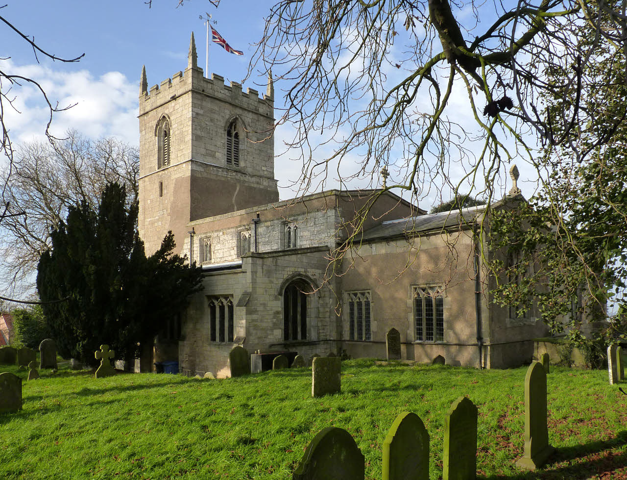
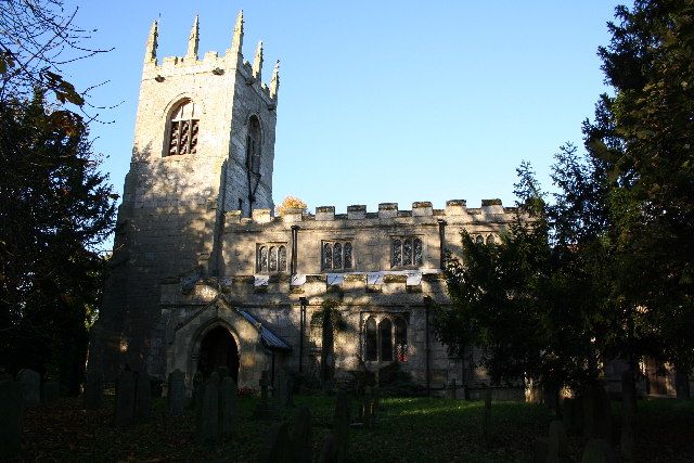
The village itself is characterized by its charming rural atmosphere, with a mix of traditional stone cottages and more modern houses. The centerpiece of Gringley on the Hill is its beautiful 12th-century church, St. Peter and St. Paul, which is a prominent landmark in the area. The church features stunning architectural details and is a notable example of medieval design.

Gringley on the Hill offers a range of amenities and services for its residents, including a primary school, a village hall, a post office, and a local shop. The village also has a pub, The Blue Bell Inn, which serves as a hub for the community and offers a place for socializing and enjoying traditional pub food.

The surrounding countryside provides ample opportunities for outdoor activities, such as walking, cycling, and horse riding. There are several footpaths and bridleways that crisscross the area, allowing residents and visitors to explore the beautiful landscape.

Overall, Gringley on the Hill is a charming and idyllic village in Nottinghamshire, offering a peaceful and rural lifestyle while still being within easy reach of larger towns and cities.

If you have any feedback on the listing, please let us know in the comments section below.

Gringley on the Hill Images

Images are sourced within 2km of 53.422018/-0.901772 or Grid Reference SK7392. Thanks to Geograph Open Source API. All images are credited.

A631 at Gringley on the Hill
Shaw Brick Works Remnant of Shaw Brick Works near Gringley on the Hill
Shaw Brick Works
Remnant of Shaw Brick Works near Gringley on the Hill
Cuckoo Way Chesterfield Canal towpath near Gringley on the Hill
Cuckoo Way
Chesterfield Canal towpath near Gringley on the Hill
Cuckoo Way Chesterfield Canal towpath near Gringley on the Hill
Cuckoo Way
Chesterfield Canal towpath near Gringley on the Hill
Outlands Farm
Outlands Farm
Ings Road
Ings Road
Footpath to Gringley Bridge
Middle Bridge
Middle Bridge
Shaw Bridge
Shaw Bridge
Chesterfield Canal
Chesterfield Canal
Looking towards Lowfield Farm This is the B1403 dropping down from Gringley on the Hill on the way to Misterton. Although the clouds in the distance looked threatening, the rain in this area at least held off.
Looking towards Lowfield Farm
This is the B1403 dropping down from Gringley on the Hill on the way to Misterton. Although the clouds in the distance looked threatening, the rain in this area at least held off.
View from Beacon Hill Beacon Hill at Gringley on the Hill provides fine views to the north and north-east across to the Trent Valley and on a clear day Lincoln Cathedral can be seen. To the north, there is no land higher than 30 feet between here and the Yorkshire Wolds. It was a prehistoric hill fortress and in the Civil War, Prince Rupert is said to have camped here before proceeding to relieve Newark.

In this view, Walkeringham Road snakes in the middle distance. Although the clouds in the distance looked threatening, the rain in this area at least held off.
View from Beacon Hill
Beacon Hill at Gringley on the Hill provides fine views to the north and north-east across to the Trent Valley and on a clear day Lincoln Cathedral can be seen. To the north, there is no land higher than 30 feet between here and the Yorkshire Wolds. It was a prehistoric hill fortress and in the Civil War, Prince Rupert is said to have camped here before proceeding to relieve Newark. In this view, Walkeringham Road snakes in the middle distance. Although the clouds in the distance looked threatening, the rain in this area at least held off.
The Churchyard of St Peter and St Paul, Gringley on the Hill The present church was begun around 1180 and originally consisted of chancel and nave, with a tower at the west end. It has a fine position in the village with views to the north.
The Churchyard of St Peter and St Paul, Gringley on the Hill
The present church was begun around 1180 and originally consisted of chancel and nave, with a tower at the west end. It has a fine position in the village with views to the north.
Middle Bridge on the Chesterfield Canal The Chesterfield Canal officially opened in 1777. It offered a more convenient and reliable outlet to the River Trent for the lead, coal and iron of north Derbyshire and South Yorkshire than did the River Idle. It originally extended 46 miles from the River Trent through Misterton, Worksop and Retford before arriving at its terminus in Chesterfield. Its own active career though was short-lived and in 1846, the canal company formed their own railway company and joined forces with the Manchester, Sheffield & Lincolnshire Railway and left the canal to look after itself. The last recorded commercial cargo was in the 1960s. 

In 1976 the Chesterfield Canal Society, now known as the Chesterfield Canal Trust, was formed. See <span class="nowrap"><a title="https://canalrivertrust.org.uk/enjoy-the-waterways/canal-and-river-network/chesterfield-canal?gclid=Cj0KCQjw_OzrBRDmARIsAAIdQ_IIa5LdoWnWvDGea6K4LDOcZvTZRXRJ_tQORSrl3yFk0xZgUclyN2caAkPpEALw_wcB" rel="nofollow ugc noopener" href="https://canalrivertrust.org.uk/enjoy-the-waterways/canal-and-river-network/chesterfield-canal?gclid=Cj0KCQjw_OzrBRDmARIsAAIdQ_IIa5LdoWnWvDGea6K4LDOcZvTZRXRJ_tQORSrl3yFk0xZgUclyN2caAkPpEALw_wcB">Link</a><img style="margin-left:2px;" alt="External link" title="External link - shift click to open in new window" src="https://s1.geograph.org.uk/img/external.png" width="10" height="10"/></span>  for full details including a map.
Middle Bridge on the Chesterfield Canal
The Chesterfield Canal officially opened in 1777. It offered a more convenient and reliable outlet to the River Trent for the lead, coal and iron of north Derbyshire and South Yorkshire than did the River Idle. It originally extended 46 miles from the River Trent through Misterton, Worksop and Retford before arriving at its terminus in Chesterfield. Its own active career though was short-lived and in 1846, the canal company formed their own railway company and joined forces with the Manchester, Sheffield & Lincolnshire Railway and left the canal to look after itself. The last recorded commercial cargo was in the 1960s. In 1976 the Chesterfield Canal Society, now known as the Chesterfield Canal Trust, was formed. See LinkExternal link for full details including a map.
Gringley Top Lock on the Chesterfield Canal The Chesterfield Canal officially opened in 1777. It offered a more convenient and reliable outlet to the River Trent for the lead, coal and iron of north Derbyshire and South Yorkshire than did the River Idle. It originally extended 46 miles from the River Trent through Misterton, Worksop and Retford before arriving at its terminus in Chesterfield. Its own active career though was short-lived and in 1846, the canal company formed their own railway company and joined forces with the Manchester, Sheffield & Lincolnshire Railway and left the canal to look after itself. The last recorded commercial cargo was in the 1960s. 

In 1976 the Chesterfield Canal Society, now known as the Chesterfield Canal Trust, was formed. See <span class="nowrap"><a title="https://canalrivertrust.org.uk/enjoy-the-waterways/canal-and-river-network/chesterfield-canal?gclid=Cj0KCQjw_OzrBRDmARIsAAIdQ_IIa5LdoWnWvDGea6K4LDOcZvTZRXRJ_tQORSrl3yFk0xZgUclyN2caAkPpEALw_wcB" rel="nofollow ugc noopener" href="https://canalrivertrust.org.uk/enjoy-the-waterways/canal-and-river-network/chesterfield-canal?gclid=Cj0KCQjw_OzrBRDmARIsAAIdQ_IIa5LdoWnWvDGea6K4LDOcZvTZRXRJ_tQORSrl3yFk0xZgUclyN2caAkPpEALw_wcB">Link</a><img style="margin-left:2px;" alt="External link" title="External link - shift click to open in new window" src="https://s1.geograph.org.uk/img/external.png" width="10" height="10"/></span>  for full details including a map.
Gringley Top Lock on the Chesterfield Canal
The Chesterfield Canal officially opened in 1777. It offered a more convenient and reliable outlet to the River Trent for the lead, coal and iron of north Derbyshire and South Yorkshire than did the River Idle. It originally extended 46 miles from the River Trent through Misterton, Worksop and Retford before arriving at its terminus in Chesterfield. Its own active career though was short-lived and in 1846, the canal company formed their own railway company and joined forces with the Manchester, Sheffield & Lincolnshire Railway and left the canal to look after itself. The last recorded commercial cargo was in the 1960s. In 1976 the Chesterfield Canal Society, now known as the Chesterfield Canal Trust, was formed. See LinkExternal link for full details including a map.
Shaw Lock on the Chesterfield Canal The Chesterfield Canal officially opened in 1777. It offered a more convenient and reliable outlet to the River Trent for the lead, coal and iron of north Derbyshire and South Yorkshire than did the River Idle. It originally extended 46 miles from the River Trent through Misterton, Worksop and Retford before arriving at its terminus in Chesterfield. Its own active career though was short-lived and in 1846, the canal company formed their own railway company and joined forces with the Manchester, Sheffield & Lincolnshire Railway and left the canal to look after itself. The last recorded commercial cargo was in the 1960s. 

In 1976 the Chesterfield Canal Society, now known as the Chesterfield Canal Trust, was formed. See <span class="nowrap"><a title="https://canalrivertrust.org.uk/enjoy-the-waterways/canal-and-river-network/chesterfield-canal?gclid=Cj0KCQjw_OzrBRDmARIsAAIdQ_IIa5LdoWnWvDGea6K4LDOcZvTZRXRJ_tQORSrl3yFk0xZgUclyN2caAkPpEALw_wcB" rel="nofollow ugc noopener" href="https://canalrivertrust.org.uk/enjoy-the-waterways/canal-and-river-network/chesterfield-canal?gclid=Cj0KCQjw_OzrBRDmARIsAAIdQ_IIa5LdoWnWvDGea6K4LDOcZvTZRXRJ_tQORSrl3yFk0xZgUclyN2caAkPpEALw_wcB">Link</a><img style="margin-left:2px;" alt="External link" title="External link - shift click to open in new window" src="https://s1.geograph.org.uk/img/external.png" width="10" height="10"/></span>  for full details including a map.
Shaw Lock on the Chesterfield Canal
The Chesterfield Canal officially opened in 1777. It offered a more convenient and reliable outlet to the River Trent for the lead, coal and iron of north Derbyshire and South Yorkshire than did the River Idle. It originally extended 46 miles from the River Trent through Misterton, Worksop and Retford before arriving at its terminus in Chesterfield. Its own active career though was short-lived and in 1846, the canal company formed their own railway company and joined forces with the Manchester, Sheffield & Lincolnshire Railway and left the canal to look after itself. The last recorded commercial cargo was in the 1960s. In 1976 the Chesterfield Canal Society, now known as the Chesterfield Canal Trust, was formed. See LinkExternal link for full details including a map.
Ings Road This is out on Gringley Carr, to the north of the Chesterfield Canal.
Ings Road
This is out on Gringley Carr, to the north of the Chesterfield Canal.
Flat land north of the Chesterfield Canal This view is from the track which leads from Shaw Bridge and Lock on the Chesterfield Canal to Leys Farm and Smith's Bridge.
Flat land north of the Chesterfield Canal
This view is from the track which leads from Shaw Bridge and Lock on the Chesterfield Canal to Leys Farm and Smith's Bridge.
Show me another place!

Gringley on the Hill is located at Grid Ref: SK7392 (Lat: 53.422018, Lng: -0.901772)

Administrative County: Nottinghamshire

District: Bassetlaw

Police Authority: Nottinghamshire

What 3 Words

///having.letters.detriment. Near Misterton, Nottinghamshire

Nearby Locations

Gringley on the Hill

Related Wikis

Gringley on the Hill

Gringley on the Hill, Nottinghamshire, is an English village and parish. The population of the civil parish at the 2011 census was 699. It is on the highest...

St Peter & St Paul's Church, Gringley-on-the-Hill

St Peter & St Paul's Church is a Grade II* listed parish church in the Church of England in Gringley-on-the-Hill. == History == The church dates from the...

Wiseton

Wiseton is a small village, country estate and civil parish, Nottinghamshire, England, situated between the villages of Gringley-on-the-Hill and Everton...

Everton, Nottinghamshire

Everton is a village and civil parish in Nottinghamshire, England. Located on the A631 between Gainsborough and Bawtry, it is part of Bassetlaw district...

Mattersey Priory

Mattersey Priory is a former monastery of the Gilbertine Order, located near the village of Mattersey, Nottinghamshire, England. It is managed by English...

Walkeringham

Walkeringham is a village and civil parish in Nottinghamshire, England. According to the 2001 census it had a population of 908, increasing to 1,022 at...

St Peter's Church, Clayworth

St. Peter's Church, Clayworth is a parish church in the Church of England in Clayworth, Nottinghamshire. The church is Grade I listed by the Department...

St Mary Magdalene's Church, Walkeringham

St Mary Magdalene's Church, Walkeringham is a Grade I listed, Church of England parish church in the village of Walkeringham, Nottinghamshire. == History... ==

Nearby Amenities

Located within 500m of 53.422018,-0.901772
Power: pole
Lat/Long: 53.4190414/-0.9062354
Power: pole
Lat/Long: 53.4195585/-0.9052518
Power: pole
Lat/Long: 53.4196203/-0.9035169
Power: pole
Lat/Long: 53.4196301/-0.9014596
Power: pole
Lat/Long: 53.4200971/-0.8997246
Power: pole
Lat/Long: 53.4205034/-0.8979891
Power: pole
Lat/Long: 53.4209967/-0.8961315
The data included in this document is from www.openstreetmap.org. The data is made available under ODbL.

Have you been to Gringley on the Hill?

Leave your review of Gringley on the Hill below (or comments, questions and feedback).