Great Oxendon

Civil Parish in Northamptonshire

England

Great Oxendon

Viewing platform, Prince Rupert's Viewpoint
Viewing platform, Prince Rupert's Viewpoint Credit: Jonathan Thacker

The requested URL returned error: 429 Too Many Requests

If you have any feedback on the listing, please let us know in the comments section below.

Great Oxendon Images

Images are sourced within 2km of 52.446932/-0.922623 or Grid Reference SP7383. Thanks to Geograph Open Source API. All images are credited.

Viewing platform, Prince Rupert's Viewpoint
Autumn sown crop alongside Clipston Road
Oxenden Road
Oxenden Road
Entrance to Oxendon Tunnel The northern entrance to Oxendon Tunnel. Once a railway tunnel it now forms part of the Midshires Way and is accessible to cyclists and walkers.
Entrance to Oxendon Tunnel
The northern entrance to Oxendon Tunnel. Once a railway tunnel it now forms part of the Midshires Way and is accessible to cyclists and walkers.
Road east of Clipston Looking towards the junction with the A508.
Road east of Clipston
Looking towards the junction with the A508.
Track to Arthingworth Taken looking east from the site of Clipston & Oxendon station on what is now the Midshires Way.  No doubt the pub sign is intended to attract walkers, although a visit would take them over a kilometre out of their way.
Track to Arthingworth
Taken looking east from the site of Clipston & Oxendon station on what is now the Midshires Way. No doubt the pub sign is intended to attract walkers, although a visit would take them over a kilometre out of their way.
Sheep near Great Oxendon Sheep on the gated road between Great Oxendon and Clipston. The cattle grid did not faze the animals, although they were wary of photographers!  Note the two hot air balloons.
Sheep near Great Oxendon
Sheep on the gated road between Great Oxendon and Clipston. The cattle grid did not faze the animals, although they were wary of photographers! Note the two hot air balloons.
Lane to Great Oxendon Looking along the narrow lane from East Farndon - Great Oxendon in blustery overcast conditions. The lane forms part of the Jurassic Way long distance path.
Lane to Great Oxendon
Looking along the narrow lane from East Farndon - Great Oxendon in blustery overcast conditions. The lane forms part of the Jurassic Way long distance path.
East Farndon The southern end of the village, looking along Main Street from close to the church gate.
East Farndon
The southern end of the village, looking along Main Street from close to the church gate.
Old Railway Trackbed near Great Oxendon A stretch of the former Northampton - Market Harborough railway in light drizzle. This now forms part of National Cycle Network route 6 and is popular with both cyclists and walkers.
Old Railway Trackbed near Great Oxendon
A stretch of the former Northampton - Market Harborough railway in light drizzle. This now forms part of National Cycle Network route 6 and is popular with both cyclists and walkers.
Trackbed of Old Railway near Great Oxendon The former Northampton - Market Harborough railway, now a cycle path, to the north of Oxendon Tunnel. At this point the route crosses a culverted stream; heavy overnight rain has caused a sizeable pool of water to form - fortunately easily avoided by cyclists and walkers.
Trackbed of Old Railway near Great Oxendon
The former Northampton - Market Harborough railway, now a cycle path, to the north of Oxendon Tunnel. At this point the route crosses a culverted stream; heavy overnight rain has caused a sizeable pool of water to form - fortunately easily avoided by cyclists and walkers.
Ventilation Shaft, Oxendon Tunnel Looking upwards from the bottom of Oxendon Tunnel to the top of the ventilation shaft, located about half way along this 418 metre long tunnel. The tunnel was last used for trains in 1984 and is now a cycle way and footpath. Although lights have been installed they are not normally lit, so walking through (without a torch) is not for the faint-hearted!
Ventilation Shaft, Oxendon Tunnel
Looking upwards from the bottom of Oxendon Tunnel to the top of the ventilation shaft, located about half way along this 418 metre long tunnel. The tunnel was last used for trains in 1984 and is now a cycle way and footpath. Although lights have been installed they are not normally lit, so walking through (without a torch) is not for the faint-hearted!
Bridleway to Great Oxendon The bridleway is the very muddy track leading off the former railway trackbed. It then crosses over the top of Oxendon Tunnel to reach Great Oxendon village, which is to the west of the old railway.
Bridleway to Great Oxendon
The bridleway is the very muddy track leading off the former railway trackbed. It then crosses over the top of Oxendon Tunnel to reach Great Oxendon village, which is to the west of the old railway.
Approaching Oxendon Tunnel Cyclists and walkers on this former railway trackbed are about to plunge into the stygian gloom of Oxendon Tunnel. Walkers are offered an alternative, but it is much less fun.
Approaching Oxendon Tunnel
Cyclists and walkers on this former railway trackbed are about to plunge into the stygian gloom of Oxendon Tunnel. Walkers are offered an alternative, but it is much less fun.
Agricultural Buildings. Buildings located beside B4036.
Agricultural Buildings.
Buildings located beside B4036.
Clipston Road on Cold Winter Day Deserted road from Clipston running north towards East Farndon.
Clipston Road on Cold Winter Day
Deserted road from Clipston running north towards East Farndon.
Country Lane to Great Oxendon.
Open Countryside
Open Countryside
Show me another place!

Great Oxendon is located at Grid Ref: SP7383 (Lat: 52.446932, Lng: -0.922623)

Unitary Authority: West Northamptonshire

Police Authority: Northamptonshire

What 3 Words

///rhino.northward.aquatic. Near Market Harborough, Leicestershire

Related Wikis

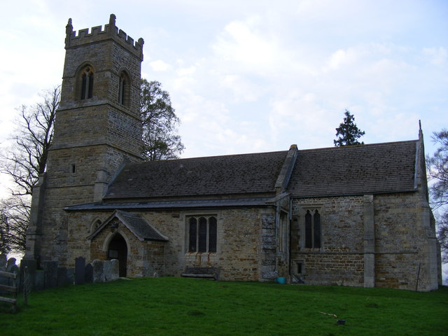
St Helen's Church, Oxendon

St Helen's Church is an Anglican Church and the parish church of Oxendon. It is a Grade II* listed building and stands on the west side of Harborough...

Great Oxendon

Great Oxendon is a linear village and civil parish in West Northamptonshire in England. At the time of the 2001 census, the parish's population was 307...
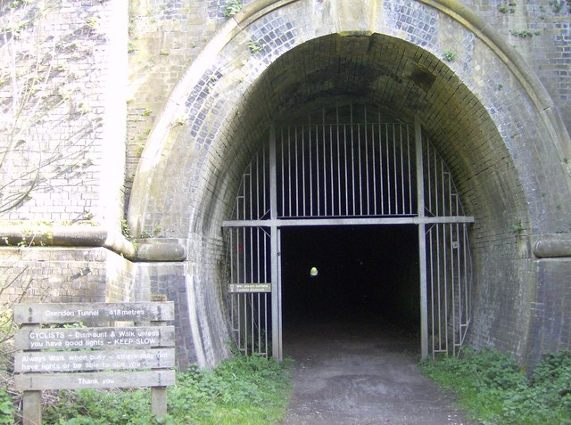
Oxendon Tunnels

The Oxendon Tunnels are disused railway tunnels in Northamptonshire, England. The Northampton to Market Harborough line opened in 1859 and had tunnels...

Little Oxendon

Little Oxendon is a deserted medieval village about one mile north of Great Oxendon (where any population is included) at grid reference SP730846. A number...

Related Videos

Walking Through Market Harborough Town Centre Winter 2022

Market Harborough town centre on a cold winter's day. At least we got to meet santa!

Nearby Amenities

Located within 500m of 52.446932,-0.922623
Post Box
Post Box Type: lamp
Ref: LE16 57
Royal Cypher: EIIR
Royal Cypher Wikidata: Q33102113
Lat/Long: 52.4430743/-0.9191469
Barrier: stile
Lat/Long: 52.4443949/-0.9180488
Barrier: stile
Lat/Long: 52.4446019/-0.9173897
Pub
The George
Addr City: Great Oxendon
Addr Country: GB
Addr Postcode: LE16 8NA
Addr Street: Harborough Road
Fhrs Authority: West Northamptonshire
Fhrs Id: 978654
Fhrs Local Authority Id: PI/000053688
Lat/Long: 52.4437495/-0.9182819
Bus Stop
Bus: yes
Public Transport: platform
Lat/Long: 52.4432391/-0.9187372
Great Oxendon
Is In County: Northamptonshire
Is In District: Daventry
Place: village
Wikidata: Q2337042
Wikipedia: en:Great Oxendon
Lat/Long: 52.4434377/-0.9192346
Social Facility
Oxendon House
Addr City: Market Harborough
Addr Country: GB
Addr Housenumber: 33
Addr Postcode: LE16 8NE
Addr Street: Main Street
Addr Village: Great Oxendon
Capacity: 45
Fhrs Authority: West Northamptonshire
Fhrs Id: 165727
Fhrs Local Authority Id: PI/000008421
Operator: Oxendon House Care Home Limited
Social Facility: assisted_living
Social Facility For: senior
Website: https://www.oxendonhouse.co.uk
Lat/Long: 52.4430822/-0.9231573
Community Centre
Great Oxendon Village Hall
Addr Country: GB
Addr Postcode: LE16 8NE
Addr Street: Main Street
Addr Village: Great Oxendon
Community Centre: village_hall
Fhrs Authority: West Northamptonshire
Fhrs Id: 165740
Fhrs Local Authority Id: PI/000008434
Lat/Long: 52.4434582/-0.9223795
Waterloo Cottage Farm Shop
Addr Country: GB
Addr Housenumber: 34
Addr Postcode: LE16 8NA
Addr Street: Harborough Road
Addr Village: Great Oxendon
Fhrs Authority: West Northamptonshire
Fhrs Id: 959994
Fhrs Local Authority Id: PI/000049592
Shop: farm
Lat/Long: 52.4459786/-0.9183391
Defibrillator
Defibrillator Location: On wall of Great Oxendon Village Hall - roadside
Emergency: defibrillator
Indoor: no
Ref GB The Circuit: 3A3B2D64-EC28-477F-8651-F6B7AA803A5A
Lat/Long: 52.4434239/-0.9223232
Barrier: stile
Lat/Long: 52.4446117/-0.9210646
Barrier: stile
Lat/Long: 52.4445555/-0.9255627
Barrier: stile
Lat/Long: 52.4446431/-0.9230353
Man Made: mast
Lat/Long: 52.4489554/-0.9277455
Barrier: stile
Lat/Long: 52.4445942/-0.9248268
Barrier: stile
Lat/Long: 52.4442435/-0.9266218
Maxspeed: 40 mph
Traffic Sign: maxspeed
Lat/Long: 52.4444874/-0.9189847
Millennium Monument
Historic: monument
Lat/Long: 52.4441714/-0.918725
Bench
Lat/Long: 52.4435612/-0.9225597
Bench
Lat/Long: 52.4431576/-0.9201438
Bench
Lat/Long: 52.4458794/-0.9190355
Public Bookcase
used book exchange
Booth: K6
Disused Amenity: telephone
Man Made: telephone_box
Public Bookcase Type: phone_box
Lat/Long: 52.4430743/-0.9191849
Grit Bin
Lat/Long: 52.4429887/-0.9191112
The data included in this document is from www.openstreetmap.org. The data is made available under ODbL.

Have you been to Great Oxendon?

Leave your review of Great Oxendon below (or comments, questions and feedback).