Crawley

Civil Parish in Oxfordshire West Oxfordshire

England

Crawley

Bird in Hand (1), Whiteoak Green, Oxon A few miles from the town of Witney and on the B4022 road. This inn serves food, drinks and has accommodation in 16 bedrooms. The building is believed to date from the 17th century.

<a href="https://www.geograph.org.uk/photo/7418831">SP3413 : Bird in Hand (2), Whiteoak Green, Oxon</a>.
<a href="https://www.geograph.org.uk/photo/7418850">SP3413 : B4022 road heading north towards Finstock, Oxon</a>.
Bird in Hand (1), Whiteoak Green, Oxon Credit: P L Chadwick

Crawley is a small civil parish located in the Cherwell district of Oxfordshire, England. Situated approximately 6 miles northwest of Oxford city center, the parish covers an area of around 1.5 square miles and is home to a population of just over 200 residents.

The picturesque village of Crawley boasts a rich history, with evidence of human habitation dating back to the Iron Age. The village is characterized by its charming thatched-roof cottages and traditional stone houses, creating a quintessential English countryside ambiance.

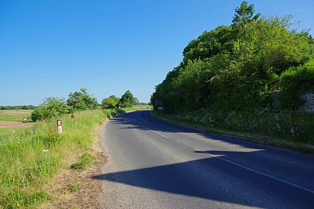
Crawley is surrounded by beautiful rural landscapes, with rolling hills, meadows, and woodlands providing a scenic backdrop. The parish is traversed by several footpaths and bridleways, making it an ideal destination for outdoor enthusiasts and nature lovers.

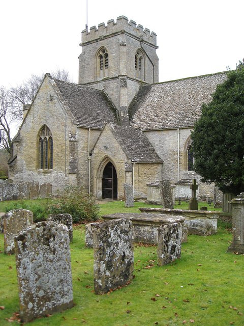
The village is home to St. Mary's Church, a grade II listed building that dates back to the 12th century. This historic church features a unique octagonal tower and houses a variety of notable architectural features.

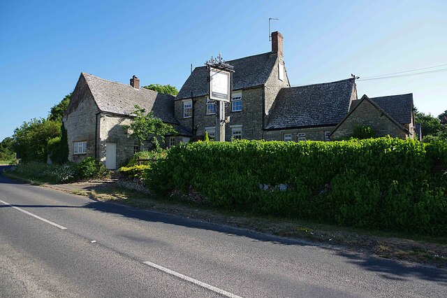
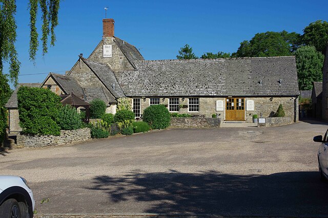
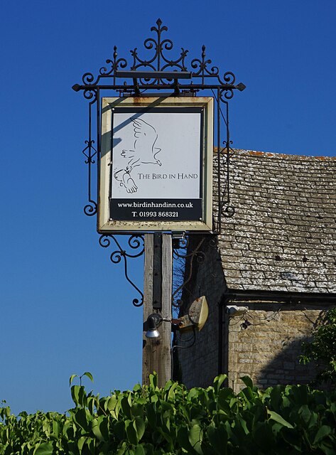
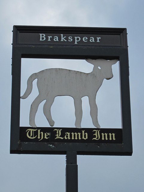
While Crawley may be small in size, it offers a strong sense of community. The parish has a local pub, The Red Lion, which serves as a gathering place for residents and visitors alike. Additionally, the village hosts various community events throughout the year, including fairs and festivals, further fostering a sense of togetherness.

Overall, Crawley is a charming and idyllic English village, offering a peaceful and tranquil retreat from the hustle and bustle of nearby urban areas.

If you have any feedback on the listing, please let us know in the comments section below.

Crawley Images

Images are sourced within 2km of 51.816969/-1.510606 or Grid Reference SP3313. Thanks to Geograph Open Source API. All images are credited.

Bird in Hand (1), Whiteoak Green, Oxon A few miles from the town of Witney and on the B4022 road. This inn serves food, drinks and has accommodation in 16 bedrooms. The building is believed to date from the 17th century.

<a href="https://www.geograph.org.uk/photo/7418831">SP3413 : Bird in Hand (2), Whiteoak Green, Oxon</a>.
<a href="https://www.geograph.org.uk/photo/7418850">SP3413 : B4022 road heading north towards Finstock, Oxon</a>.
Bird in Hand (1), Whiteoak Green, Oxon
A few miles from the town of Witney and on the B4022 road. This inn serves food, drinks and has accommodation in 16 bedrooms. The building is believed to date from the 17th century. SP3413 : Bird in Hand (2), Whiteoak Green, Oxon. SP3413 : B4022 road heading north towards Finstock, Oxon.
Bird in Hand (2), Whiteoak Green, Oxon Photographed from the car park.

See also:- <a href="https://www.geograph.org.uk/photo/7418821">SP3413 : Bird in Hand (1), Whiteoak Green, Oxon</a>; <a href="https://www.geograph.org.uk/photo/7418836">SP3413 : Bird in Hand (3) - sign, Whiteoak Green, Oxon</a>.
Bird in Hand (2), Whiteoak Green, Oxon
Bird in Hand (3) - sign, Whiteoak Green, Oxon The sign is on a pole adjacent to the B4022 road. Since this photograph was taken, the sign has been replaced by a different design incorporating a white bird on a sky blue background.

<a href="https://www.geograph.org.uk/photo/7418821">SP3413 : Bird in Hand (1), Whiteoak Green, Oxon</a>.
<a href="https://www.geograph.org.uk/photo/7418831">SP3413 : Bird in Hand (2), Whiteoak Green, Oxon</a>.
Bird in Hand (3) - sign, Whiteoak Green, Oxon
The sign is on a pole adjacent to the B4022 road. Since this photograph was taken, the sign has been replaced by a different design incorporating a white bird on a sky blue background. SP3413 : Bird in Hand (1), Whiteoak Green, Oxon. SP3413 : Bird in Hand (2), Whiteoak Green, Oxon.
B4022 road heading north towards Finstock, Oxon The road here is just passing the Bird in Hand inn.

<a href="https://www.geograph.org.uk/photo/7418821">SP3413 : Bird in Hand (1), Whiteoak Green, Oxon</a>.
B4022 road heading north towards Finstock, Oxon
The road here is just passing the Bird in Hand inn. SP3413 : Bird in Hand (1), Whiteoak Green, Oxon.
Derelict shed In a field just east of Dodds Farm, beside the road from Field Assarts to Crawley.
Derelict shed
In a field just east of Dodds Farm, beside the road from Field Assarts to Crawley.
Derelict shed near Dodds Farm Just east of the farm, in a field beside the road from Field Assarts to Crawley.
Derelict shed near Dodds Farm
Just east of the farm, in a field beside the road from Field Assarts to Crawley.
Crawley War Memorial, Foxburrow Lane, Crawley Located on the small triangular village green, the memorial commemorates the dead of both World Wars.
Crawley War Memorial, Foxburrow Lane, Crawley
Located on the small triangular village green, the memorial commemorates the dead of both World Wars.
The Lamb Inn (1), Crawley This 18th century inn was taken over in 2008 by a local chef and his wife. As well as having a wide menu, the pub also sells traditional cask ales brewed at the local Wychwood Brewery.

<a href="https://www.geograph.org.uk/photo/2711245">SP3412 : The Lamb Inn (2), Crawley</a>.
<a href="https://www.geograph.org.uk/photo/2711252">SP3412 : The Lamb Inn (3) - sign, Crawley</a>.
The Lamb Inn (1), Crawley
This 18th century inn was taken over in 2008 by a local chef and his wife. As well as having a wide menu, the pub also sells traditional cask ales brewed at the local Wychwood Brewery. SP3412 : The Lamb Inn (2), Crawley. SP3412 : The Lamb Inn (3) - sign, Crawley.
The Lamb Inn (2), Crawley The Lamb Inn is a Grade II listed building. Part is 18th century, but according to the listing part is believed to probably date from the mid-17th century.

<a href="https://www.geograph.org.uk/photo/2711224">SP3412 : The Lamb Inn (1), Crawley</a>.
<a href="https://www.geograph.org.uk/photo/2711252">SP3412 : The Lamb Inn (3) - sign, Crawley</a>.
The Lamb Inn (2), Crawley
The Lamb Inn is a Grade II listed building. Part is 18th century, but according to the listing part is believed to probably date from the mid-17th century. SP3412 : The Lamb Inn (1), Crawley. SP3412 : The Lamb Inn (3) - sign, Crawley.
The Lamb Inn (3) - sign, Crawley The sign indicates this was formerly a Brakspear's house.

The lamb is of great significance in Christianity, and the inn may have been given the name because of this connection. An alternative suggestion might be the local significance of the wool industry, particularly in nearby Witney, which was famous for its woollen blankets. In truth, often the reason why a pub or inn got its name has been lost with the passage of time.

<a href="https://www.geograph.org.uk/photo/2711224">SP3412 : The Lamb Inn (1), Crawley</a>.
<a href="https://www.geograph.org.uk/photo/2711245">SP3412 : The Lamb Inn (2), Crawley</a>.
The Lamb Inn (3) - sign, Crawley
The sign indicates this was formerly a Brakspear's house. The lamb is of great significance in Christianity, and the inn may have been given the name because of this connection. An alternative suggestion might be the local significance of the wool industry, particularly in nearby Witney, which was famous for its woollen blankets. In truth, often the reason why a pub or inn got its name has been lost with the passage of time. SP3412 : The Lamb Inn (1), Crawley. SP3412 : The Lamb Inn (2), Crawley.
Leafield Road Leafield Road passing drive and footpath down to The Courtyard and Uphill Farm
Leafield Road
Leafield Road passing drive and footpath down to The Courtyard and Uphill Farm
Lane to Middletown Lane to Middletown by Broken Hatch Farm
Lane to Middletown
Lane to Middletown by Broken Hatch Farm
Nearing the main road into Middletown Lane from Broken Hatch Farm nearing the main road into Middletown
Nearing the main road into Middletown
Lane from Broken Hatch Farm nearing the main road into Middletown
Priest Hill Lane Priest Hill Lane heading to Crawley
Priest Hill Lane
Priest Hill Lane heading to Crawley
The Village Green Delly End The village green Delly End
The Village Green Delly End
The village green Delly End
Saint John's Lane Saint John's Lane heading to New Found Out Farm
Saint John's Lane
Saint John's Lane heading to New Found Out Farm
Akeman Street heading to Chasewood Farm From New Found Out Farm Akeman Street heading to Chasewood Farm
Akeman Street heading to Chasewood Farm
From New Found Out Farm Akeman Street heading to Chasewood Farm
Akeman Street Akeman Street passing across the drive at Chasewood Farm
Akeman Street
Akeman Street passing across the drive at Chasewood Farm
Show me another place!

Crawley is located at Grid Ref: SP3313 (Lat: 51.816969, Lng: -1.510606)

Administrative County: Oxfordshire

District: West Oxfordshire

Police Authority: Thames Valley

What 3 Words

///wipes.estimates.stow. Near Minster Lovell, Oxfordshire

Nearby Locations

Crawley

Related Wikis

Crawley, Oxfordshire

Crawley is a village and civil parish beside the River Windrush about 2+1⁄2 miles (4 km) north of Witney, Oxfordshire. The parish extends from the Windrush...

Hailey, Oxfordshire

Hailey is a village and civil parish about 2 miles (3 km) north of Witney, Oxfordshire. The village comprises three neighbourhoods: Middletown on the main...

Witney (UK Parliament constituency)

Witney is a county constituency in Oxfordshire represented in the House of Commons of the Parliament of the United Kingdom since 2016 by Robert Courts...

Minster Lovell Hall

Minster Lovell Hall is a ruin in Minster Lovell, an English village in the Oxfordshire Cotswolds. The ruins are situated by the River Windrush. == History... ==

Minster Lovell Priory

Minster Lovell Priory was a priory in Minster Lovell, Oxfordshire, England. Its current site is lost, though it is thought to have been west of St Kenelm...

Leafield Castle

Leafield Castle (also known as Leafield Barrow) is a motte castle in the village of Leafield in the north west region of Oxfordshire. All that is left...

Minster Lovell

Minster Lovell is a village and civil parish on the River Windrush about 2+1⁄2 miles (4 km) west of Witney in Oxfordshire. The 2011 Census recorded the...

King's School, Witney

The King's School is a co-educational independent Christian school in Witney, Oxfordshire, England that is part of Oxfordshire Community Churches (OCC...

Nearby Amenities

Located within 500m of 51.816969,-1.510606
The data included in this document is from www.openstreetmap.org. The data is made available under ODbL.

Have you been to Crawley?

Leave your review of Crawley below (or comments, questions and feedback).