Calton

Civil Parish in Yorkshire Craven

England

Calton

Bridleway to Scosthrop Lane
Bridleway to Scosthrop Lane Credit: Alexander P Kapp

Calton is a civil parish located in the county of Yorkshire, England. Situated in the district of Ryedale, it is a small, rural village surrounded by picturesque countryside. Calton is approximately 6 miles north of the market town of Malton and just over 20 miles east of the historic city of York.

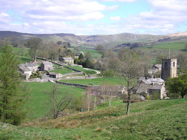
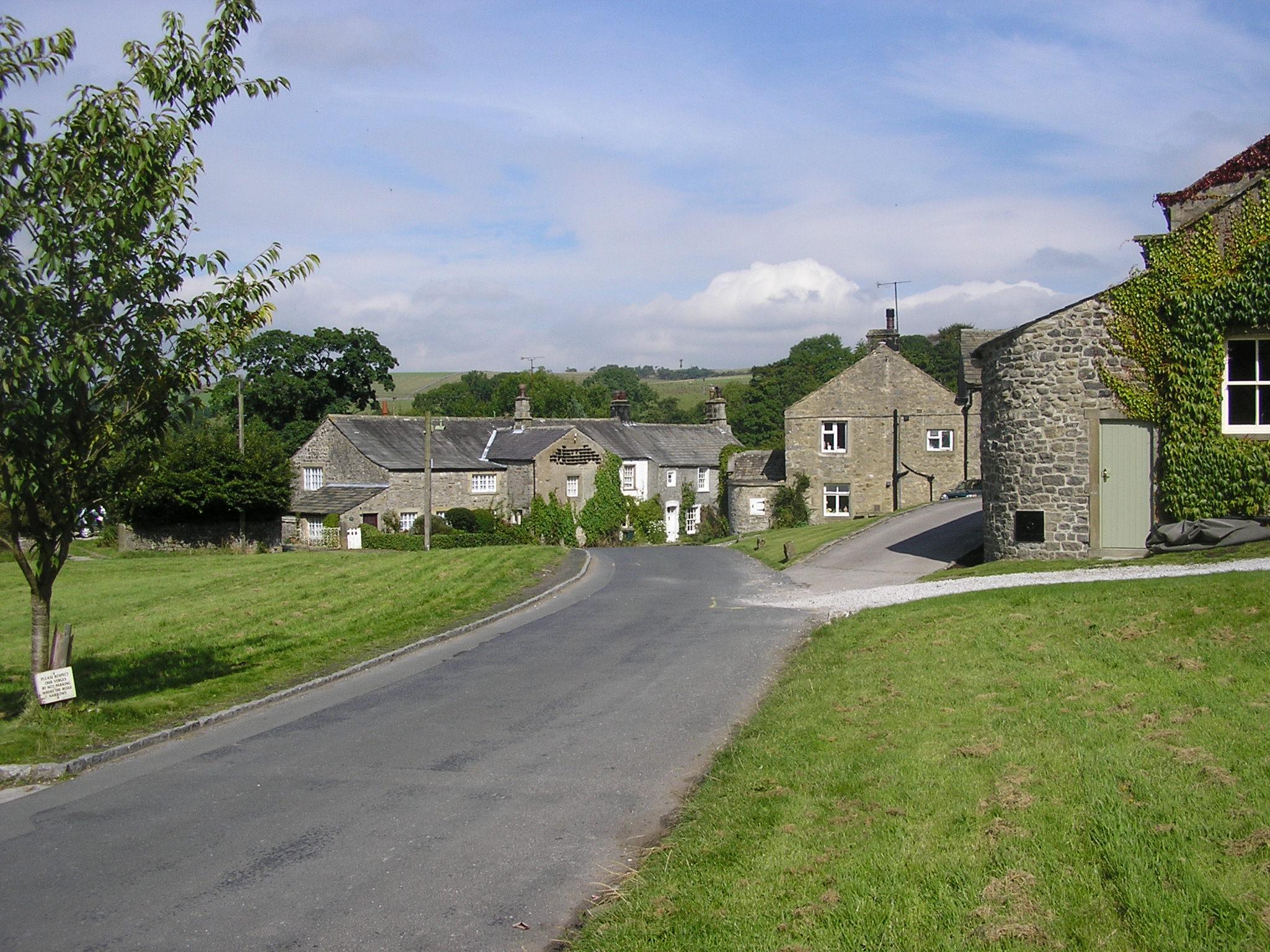
The village itself is characterized by its charming, traditional stone houses, many of which date back several centuries. The population of Calton is relatively small, with around 200 residents. The parish is known for its tight-knit community and strong sense of local pride.

The landscape surrounding Calton is predominantly agricultural, with rolling hills and fields dominating the scenery. The area is renowned for its farming heritage, with sheep and cattle farming being prominent activities. The village is also home to several well-preserved barns and outbuildings that showcase the area's agricultural history.

Despite its rural location, Calton benefits from good transportation links. The A64 road runs nearby, providing easy access to York, Scarborough, and other neighboring towns. The village is also served by a number of bus routes, connecting residents to the wider area.

In terms of amenities, Calton has a village hall that hosts various community events and activities. There are no shops or schools in the immediate area, with residents typically traveling to nearby towns for their daily needs.

Overall, Calton offers a tranquil and idyllic setting for those seeking a peaceful countryside lifestyle, surrounded by stunning natural beauty and a close-knit community.

If you have any feedback on the listing, please let us know in the comments section below.

Calton Images

Images are sourced within 2km of 54.033469/-2.130735 or Grid Reference SD9159. Thanks to Geograph Open Source API. All images are credited.

Bridleway to Scosthrop Lane
Houses, Scosthrop Lane, Scosthrop Settle Road is only short, then the name changes to Scosthrop Lane.  These two houses have a strip of grass in front – the remains of a village green?
Houses, Scosthrop Lane, Scosthrop
Settle Road is only short, then the name changes to Scosthrop Lane. These two houses have a strip of grass in front – the remains of a village green?
Scosthrop Lane, Scosthrop A country lane leading to Settle, but we are not quite out of the village, the last row of houses is in the centre of the view.
Scosthrop Lane, Scosthrop
A country lane leading to Settle, but we are not quite out of the village, the last row of houses is in the centre of the view.
Lonely Ash Tree near Airton Passed by on the footpath between Kirkby Malham and Airton.
Lonely Ash Tree near Airton
Passed by on the footpath between Kirkby Malham and Airton.
Ready for the winter Bales of hay, wrapped in plastic, stacked at a farm in Scosthrop.
Ready for the winter
Bales of hay, wrapped in plastic, stacked at a farm in Scosthrop.
Bridleway to Town End, Airton This links the two roads which leave Airton to the west.
Bridleway to Town End, Airton
This links the two roads which leave Airton to the west.
Cows by Moor End Farm
Sheep grazing in the Aire Valley
Sheep grazing by the River Aire The River Aire is a 71 mile long river in Yorkshire. It rises at Aire Head <a href="https://www.geograph.org.uk/photo/4623446">SD9062 : Aire Head Spring</a> near Malham. It joins the River Ouse at Airmyn.
Wikipedia: <span class="nowrap"><a title="http://en.wikipedia.org/wiki/River_Aire" rel="nofollow ugc noopener" href="http://en.wikipedia.org/wiki/River_Aire">Link</a><img style="margin-left:2px;" alt="External link" title="External link - shift click to open in new window" src="https://s1.geograph.org.uk/img/external.png" width="10" height="10"/></span>
Sheep grazing by the River Aire
The River Aire is a 71 mile long river in Yorkshire. It rises at Aire Head SD9062 : Aire Head Spring near Malham. It joins the River Ouse at Airmyn. Wikipedia: LinkExternal link
The Pennine Way near Skellands
The Pennine Way near Low Gill Laithe
River Aire and Pennine Way side by side The river looking upstream between the villages at Airton and Hanlith.
River Aire and Pennine Way side by side
The river looking upstream between the villages at Airton and Hanlith.
Cattle blocking a gate on The Pennine Way near Hanlith Wood The Pennine Way is a National Trail in England, with a small section in Scotland. The trail runs 267 miles from Edale, in the northern Derbyshire Peak District, north through the Yorkshire Dales and the Northumberland National Park and ends at Kirk Yetholm, just inside the Scottish border. The path runs along the Pennine hills, sometimes described as the "backbone of England". Although not the United Kingdom's longest National Trail, it is according to the Ramblers' Association "one of Britain's best known and toughest".
Cattle blocking a gate on The Pennine Way near Hanlith Wood
The Pennine Way is a National Trail in England, with a small section in Scotland. The trail runs 267 miles from Edale, in the northern Derbyshire Peak District, north through the Yorkshire Dales and the Northumberland National Park and ends at Kirk Yetholm, just inside the Scottish border. The path runs along the Pennine hills, sometimes described as the "backbone of England". Although not the United Kingdom's longest National Trail, it is according to the Ramblers' Association "one of Britain's best known and toughest".
Cattle blocking a gate on The Pennine Way near Hanlith Wood
The Pennine Way and The River Aire opposite Skellands The River Aire is a 71 mile long river in Yorkshire. It rises at Aire Head <a href="https://www.geograph.org.uk/photo/4623446">SD9062 : Aire Head Spring</a> near Malham. It joins the River Ouse at Airmyn.
Wikipedia: <span class="nowrap"><a title="http://en.wikipedia.org/wiki/River_Aire" rel="nofollow ugc noopener" href="http://en.wikipedia.org/wiki/River_Aire">Link</a><img style="margin-left:2px;" alt="External link" title="External link - shift click to open in new window" src="https://s1.geograph.org.uk/img/external.png" width="10" height="10"/></span>
The Pennine Way and The River Aire opposite Skellands
The River Aire is a 71 mile long river in Yorkshire. It rises at Aire Head SD9062 : Aire Head Spring near Malham. It joins the River Ouse at Airmyn. Wikipedia: LinkExternal link
A view across The River Aire towards Skellands
The River Aire seen from The Pennine Way opposite Skellands The River Aire is a 71 mile long river in Yorkshire. It rises at Aire Head <a href="https://www.geograph.org.uk/photo/4623446">SD9062 : Aire Head Spring</a> near Malham. It joins the River Ouse at Airmyn.
Wikipedia: <span class="nowrap"><a title="http://en.wikipedia.org/wiki/River_Aire" rel="nofollow ugc noopener" href="http://en.wikipedia.org/wiki/River_Aire">Link</a><img style="margin-left:2px;" alt="External link" title="External link - shift click to open in new window" src="https://s1.geograph.org.uk/img/external.png" width="10" height="10"/></span>
The River Aire seen from The Pennine Way opposite Skellands
The River Aire is a 71 mile long river in Yorkshire. It rises at Aire Head SD9062 : Aire Head Spring near Malham. It joins the River Ouse at Airmyn. Wikipedia: LinkExternal link
Kirkby Brow, Skellands, Airton A close-up of the post box can be seen in <a href="https://www.geograph.org.uk/photo/7278670">SD8960 : Post box, Kirkby Brow, Skellands, Airton</a>.
Kirkby Brow, Skellands, Airton
A close-up of the post box can be seen in SD8960 : Post box, Kirkby Brow, Skellands, Airton.
Show me another place!

Calton is located at Grid Ref: SD9159 (Lat: 54.033469, Lng: -2.130735)

Division: West Riding

Administrative County: North Yorkshire

District: Craven

Police Authority: North Yorkshire

What 3 Words

///giraffes.gulped.truck. Near Gargrave, North Yorkshire

Nearby Locations

Calton

Related Wikis

Calton, North Yorkshire

Calton is a village and civil parish in the Craven district of North Yorkshire, England, on the River Aire in Airedale. In both the 2001 and 2011 Censuses...

Kirkby Malham

Kirkby Malham is a small village and civil parish in the Craven district of North Yorkshire, England. Situated in the Yorkshire Dales it lies 5 miles...

Airton

Airton (also known as Airton-in-Craven) is a small village and civil parish in North Yorkshire, England, situated 10 miles (16 km) north-west of Skipton...

Scosthrop

Scosthrop is a civil parish in the Craven district of North Yorkshire, England. The population as taken at the 2011 Census was less than 100. Details are...

Nearby Amenities

Located within 500m of 54.033469,-2.130735
Note: Didn't notice a ford here - may be dry most of the time
Note2: Yes there is a ford (water running whenI went) and also foot bridge
Lat/Long: 54.0319342/-2.1375101
Bench
Source: GPS survey
Lat/Long: 54.0320189/-2.137105
Air Hill
Ele Ft: 894
Man Made: survey_point
Natural: peak
Source: NLS-OS-1st_Series;OS sheet 150,publ 1853
Source Name: OS sheet 150,publ 1853
Lat/Long: 54.0344452/-2.1279819
The data included in this document is from www.openstreetmap.org. The data is made available under ODbL.

Have you been to Calton?

Leave your review of Calton below (or comments, questions and feedback).