Broughton

Civil Parish in Oxfordshire Cherwell

England

Broughton

Broughton Park and St. Mary's church
Broughton Park and St. Mary's church Credit: Jonathan Thacker

Broughton is a civil parish located in Oxfordshire, England. Situated approximately 7 miles southwest of Banbury, it covers an area of around 1,840 acres. The parish is predominantly rural, characterized by picturesque landscapes, rolling hills, and lush green fields.

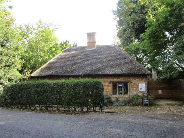
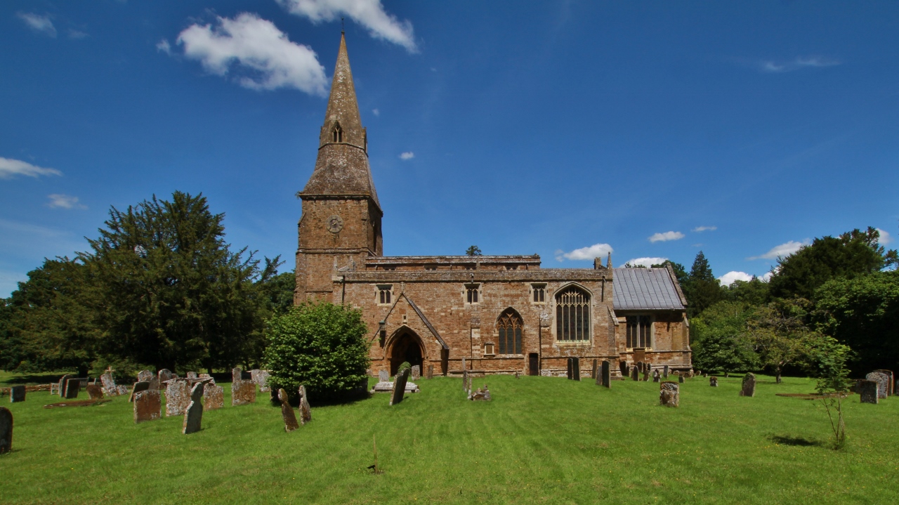
The village of Broughton itself is a small, close-knit community with a population of around 200 residents. It boasts a charming mix of traditional stone cottages, some of which date back to the 17th century, and modern houses. The village is centered around St. Mary's Church, a beautiful medieval building with a distinctive tower.

Broughton offers a peaceful and serene environment, making it an ideal place for those seeking a quiet countryside lifestyle. The village is surrounded by stunning countryside, providing ample opportunities for outdoor activities such as walking, cycling, and horse riding. The nearby River Cherwell also presents opportunities for fishing and boating enthusiasts.

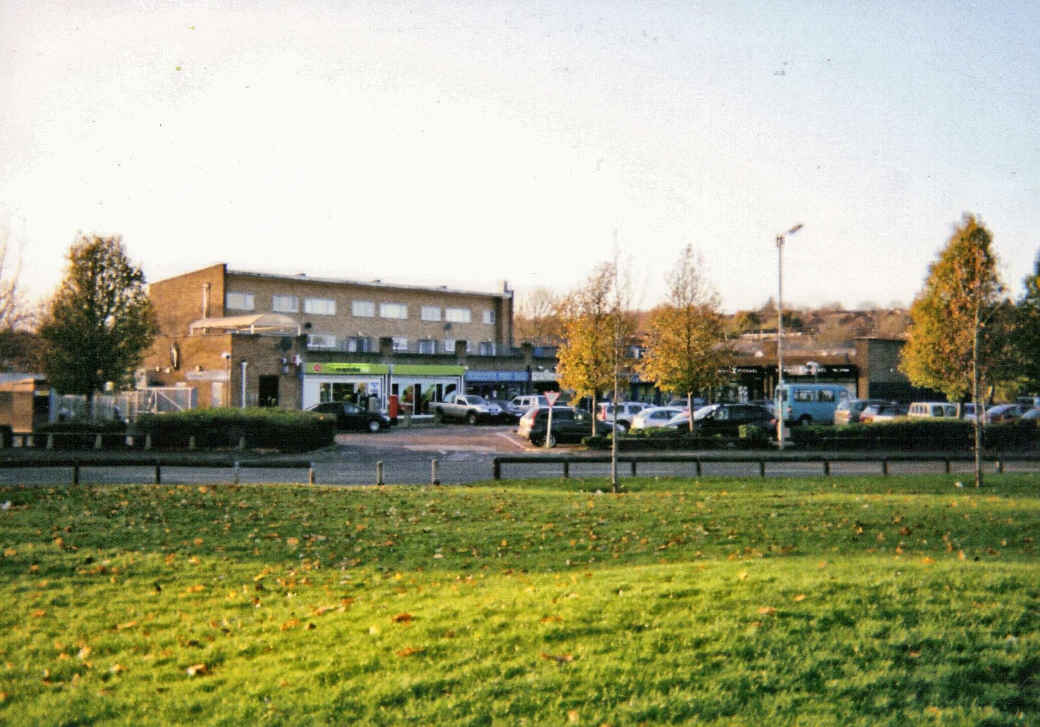
While primarily residential, Broughton is home to a few local businesses, including a village pub and a farm shop. For further amenities, residents typically travel to nearby towns such as Banbury or Oxford.

Broughton is well-connected by road, with the A423 running through the parish, offering easy access to neighboring towns and cities. The village also benefits from a regular bus service, ensuring convenient transportation options for residents.

Overall, Broughton is a charming and tranquil parish, offering a slice of rural paradise to its residents and visitors alike.

If you have any feedback on the listing, please let us know in the comments section below.

Broughton Images

Images are sourced within 2km of 52.045342/-1.390984 or Grid Reference SP4138. Thanks to Geograph Open Source API. All images are credited.

Broughton Park and St. Mary's church
The Hat Box, Broughton Nineteenth century cottage.
The Hat Box, Broughton
Nineteenth century cottage.
Harrowed field near North Newington Mill
Fields near Broughton
Lodge to Broughton Castle Dates from about 1840 <span class="nowrap"><a title="https://historicengland.org.uk/listing/the-list/list-entry/1277776" rel="nofollow ugc noopener" href="https://historicengland.org.uk/listing/the-list/list-entry/1277776">Link</a><img style="margin-left:2px;" alt="External link" title="External link - shift click to open in new window" src="https://s1.geograph.org.uk/img/external.png" width="10" height="10"/></span>
Lodge to Broughton Castle
Dates from about 1840 LinkExternal link
Roadway in Broughton Park
Broughton Park Even when the castle is closed to visitors the park is often open to the public.
Broughton Park
Even when the castle is closed to visitors the park is often open to the public.
The moat, Broughton Castle
The moat and gatehouse, Broughton Castle The gatehouse and most of the features around it date from the fourteenth century <span class="nowrap"><a title="https://historicengland.org.uk/listing/the-list/list-entry/1248762" rel="nofollow ugc noopener" href="https://historicengland.org.uk/listing/the-list/list-entry/1248762">Link</a><img style="margin-left:2px;" alt="External link" title="External link - shift click to open in new window" src="https://s1.geograph.org.uk/img/external.png" width="10" height="10"/></span>
The moat and gatehouse, Broughton Castle
The gatehouse and most of the features around it date from the fourteenth century LinkExternal link
Avenue leading to the gatehouse, Broughton Castle
Church of St. Mary the Virgin, Broughton Dates from about 1300 with later additions and alterations <span class="nowrap"><a title="https://historicengland.org.uk/listing/the-list/list-entry/1248778" rel="nofollow ugc noopener" href="https://historicengland.org.uk/listing/the-list/list-entry/1248778">Link</a><img style="margin-left:2px;" alt="External link" title="External link - shift click to open in new window" src="https://s1.geograph.org.uk/img/external.png" width="10" height="10"/></span>
The church is close to the castle but some distance from the village.
Church of St. Mary the Virgin, Broughton
Dates from about 1300 with later additions and alterations LinkExternal link The church is close to the castle but some distance from the village.
Footpath from the church to the village, Broughton
Warren Lodge, Broughton Designed by George Gilbert Scott junior in 1877.
Warren Lodge, Broughton
Designed by George Gilbert Scott junior in 1877.
Almshouses, Broughton Built in 1859 as a result of the benefaction of Elizabeth Bradford-Wyatt <span class="nowrap"><a title="https://historicengland.org.uk/listing/the-list/list-entry/1248764" rel="nofollow ugc noopener" href="https://historicengland.org.uk/listing/the-list/list-entry/1248764">Link</a><img style="margin-left:2px;" alt="External link" title="External link - shift click to open in new window" src="https://s1.geograph.org.uk/img/external.png" width="10" height="10"/></span>
Almshouses, Broughton
Built in 1859 as a result of the benefaction of Elizabeth Bradford-Wyatt LinkExternal link
Junction of power lines near North Newington Mill
Farmland on the side of Crouch Hill The south western side of the hill, on a dull misty day.
Farmland on the side of Crouch Hill
The south western side of the hill, on a dull misty day.
The next field lined up for housing expansion The Bloxham Vale housing development will spread from the left across this field.
The next field lined up for housing expansion
The Bloxham Vale housing development will spread from the left across this field.
The Salt Way An ancient right of way. It bends round to the right here towards Broughton Road, though a footpath used to continue straight on. There was once a farm on the right called Pike Farm.
The Salt Way
An ancient right of way. It bends round to the right here towards Broughton Road, though a footpath used to continue straight on. There was once a farm on the right called Pike Farm.
Show me another place!

Broughton is located at Grid Ref: SP4138 (Lat: 52.045342, Lng: -1.390984)

Administrative County: Oxfordshire

District: Cherwell

Police Authority: Thames Valley

What 3 Words

///condiment.chitchat.action. Near Bloxham, Oxfordshire

Nearby Locations

Broughton

Related Wikis

Broughton, Oxfordshire

Broughton is a village and civil parish in northern Oxfordshire, England, about 2+1⁄2 miles (4 km) southwest of Banbury. The 2011 Census recorded the...
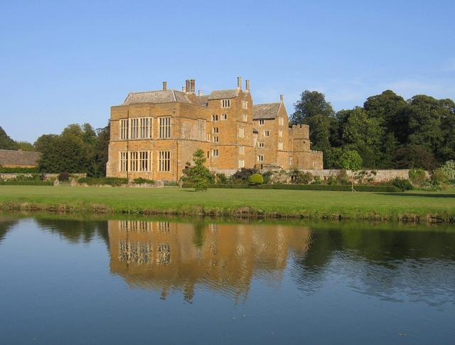
Broughton Castle

Broughton Castle is a medieval fortified manor house in the village of Broughton, which is about two miles south-west of Banbury in Oxfordshire, England...

North Newington

North Newington is a village and civil parish in northern Oxfordshire, England, about 2 miles (3 km) west of Banbury. The 2011 Census recorded the parish...

Crouch Hill, Banbury

Crouch Hill (The name of the hill comes from the Celtic "crug", meaning hill.) is a partly artificial hill one mile to the south-west of Banbury Church...

Tudor Hall School, Banbury

Tudor Hall School is a private day and boarding school for girls in Oxfordshire, situated between Bloxham and Banbury. It was founded by a Baptist Minister...

Oxfordshire Ironstone Railway

The Oxfordshire Ironstone Railway was a standard-gauge mineral railway that served an ironstone quarry near the village of Wroxton in Oxfordshire. ��2...

Neithrop

Neithrop is an inner housing estate and part of the greater 'Neithrop ward' of Banbury, Oxfordshire, England. It is one of the oldest areas in Banbury...

Ruscote

The Ruscote, Hardwick and Hanwell Fields estates are three interconnecting Banbury estates that were built between the 1930s and 2000s in Oxfordshire,...

Nearby Amenities

Located within 500m of 52.045342,-1.390984
Broughton
Place: village
Lat/Long: 52.0431823/-1.3861381
Danvers Road
Naptan AtcoCode: 340001474CNR
Naptan Bearing: SW
Naptan BusStopType: CUS
Naptan CommonName: Danvers Road
Naptan Indicator: Corner
Naptan Landmark: Danvers Road
Naptan NaptanCode: oxfagtwj
Naptan Street: Main Road
Naptan Verified: no
Source: naptan_import
Lat/Long: 52.0442867/-1.3850039
Danvers Road
Naptan AtcoCode: 340001474OPP
Naptan Bearing: NE
Naptan BusStopType: CUS
Naptan CommonName: Danvers Road
Naptan Indicator: Opposite
Naptan Landmark: Danvers Road
Naptan NaptanCode: oxfagtwg
Naptan Street: Main Road
Naptan Verified: no
Source: naptan_import
Lat/Long: 52.0443143/-1.3851202
Bus Stop
Wykham Lane
Bench: no
Bin: no
Bus: yes
Check Date Bin: 2022-08-17
Lit: no
Naptan AtcoCode: 340001475CNR
Naptan Bearing: NE
Naptan BusStopType: CUS
Naptan CommonName: Wykham Lane
Naptan Indicator: Corner
Naptan Landmark: Pub
Naptan NaptanCode: oxfagtwd
Naptan Street: Main Road
Naptan Verified: no
Public Transport: platform
Shelter: no
Source: naptan_import
Tactile Paving: no
Lat/Long: 52.0426359/-1.3874178
Bus Stop
Wykham Lane
Bench: no
Bin: no
Bus: yes
Check Date Bench: 2022-08-17
Lit: no
Naptan AtcoCode: 340001475OPP
Naptan Bearing: SW
Naptan BusStopType: CUS
Naptan CommonName: Wykham Lane
Naptan Indicator: Opposite
Naptan Landmark: Pub
Naptan NaptanCode: oxfagtdw
Naptan Street: Main Road
Naptan Verified: no
Public Transport: platform
Shelter: no
Source: naptan_import
Tactile Paving: no
Lat/Long: 52.0426008/-1.3875786
Barrier: stile
Material: stone
Source: local_knowledge
Step Count: 1
Stile: stepover
Lat/Long: 52.0439967/-1.3908299
Material: wood
Power: pole
Lat/Long: 52.047338/-1.3847446
Barrier: stile
Material: wood
Stile: stepover
Lat/Long: 52.0453948/-1.3838681
Barrier: cattle_grid
Lat/Long: 52.0436642/-1.3906561
Material: wood
Power: pole
Source: Bing
Lat/Long: 52.0448181/-1.3904381
Material: wood
Power: pole
Source: Bing
Lat/Long: 52.0460096/-1.388809
Material: wood
Power: pole
Source: Bing
Lat/Long: 52.0466136/-1.3879731
Material: wood
Power: pole
Source: Bing
Lat/Long: 52.0467125/-1.3854955
Material: wood
Power: pole
Source: Bing
Lat/Long: 52.0443739/-1.3909883
Material: wood
Power: pole
Source: Bing
Lat/Long: 52.045382/-1.3896687
Material: wood
Power: pole
Source: Bing
Lat/Long: 52.0467813/-1.3890892
Barrier: stile
Material: wood
Stile: stepover
Lat/Long: 52.0456879/-1.394048
Post Box
Brand: Royal Mail
Brand Wikidata: Q638098
Brand Wikipedia: en:Royal Mail
Collection Times: Mo-Fr 09:00; Sa 09:00
Operator: Royal Mail
Operator Wikidata: Q638098
Post Box Type: wall
Ref: OX15 1070D
Royal Cypher: GVIR
Royal Cypher Wikidata: Q33102169
Source: drive-by survey
Lat/Long: 52.0426829/-1.3876179
Barrier: cattle_grid
Lat/Long: 52.0422706/-1.3912668
Material: wood
Power: pole
Lat/Long: 52.0476608/-1.3853663
Material: wood
Power: pole
Lat/Long: 52.0464589/-1.3868016
Material: wood
Power: pole
Lat/Long: 52.0469127/-1.3900642
Material: wood
Power: pole
Lat/Long: 52.043954/-1.3909855
Natural: tree_stump
Lat/Long: 52.0427451/-1.3927236
Natural: tree_stump
Lat/Long: 52.0456457/-1.3950031
Natural: tree_stump
Lat/Long: 52.0413173/-1.3939666
Natural: tree_stump
Lat/Long: 52.0420584/-1.3913084
Natural: tree_stump
Lat/Long: 52.045099/-1.3970807
Turning Loop
Lat/Long: 52.041737/-1.3892882
Defibrillator
Emergency: defibrillator
Indoor: no
Lat/Long: 52.0425135/-1.3879135
Fire Hydrant
Emergency: fire_hydrant
Fire Hydrant Position: sidewalk
Fire Hydrant Type: underground
Water Source: main
Lat/Long: 52.0438031/-1.3857469
The data included in this document is from www.openstreetmap.org. The data is made available under ODbL.

Have you been to Broughton?

Leave your review of Broughton below (or comments, questions and feedback).