Borrowdale

Civil Parish in Cumberland Allerdale

England

Borrowdale

Rocks and bracken at summit area of High Doat The northward view from the high point of the modest hill, High Doat near to Seatoller in Borrowdale.
Castle Crag lies at the centre of the image with the Skiddaw group in the distance, the highest tops hidden in mist.
Rocks and bracken at summit area of High Doat Credit: Trevor Littlewood

Borrowdale is a civil parish located in the county of Cumberland in England. It lies within the picturesque Lake District National Park and is known for its stunning natural beauty. The parish covers an area of approximately 100 square kilometers and is home to a small population.

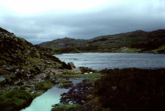
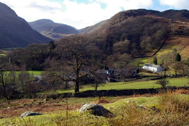
The landscape of Borrowdale is dominated by mountains, lakes, and valleys, making it a popular destination for outdoor enthusiasts and nature lovers. The famous Lake Derwentwater is situated within the parish, offering visitors opportunities for boating, fishing, and scenic walks along its shores. The surrounding mountains, including Scafell Pike, England's highest peak, provide excellent hiking and climbing routes, attracting adventurers from all over the world.

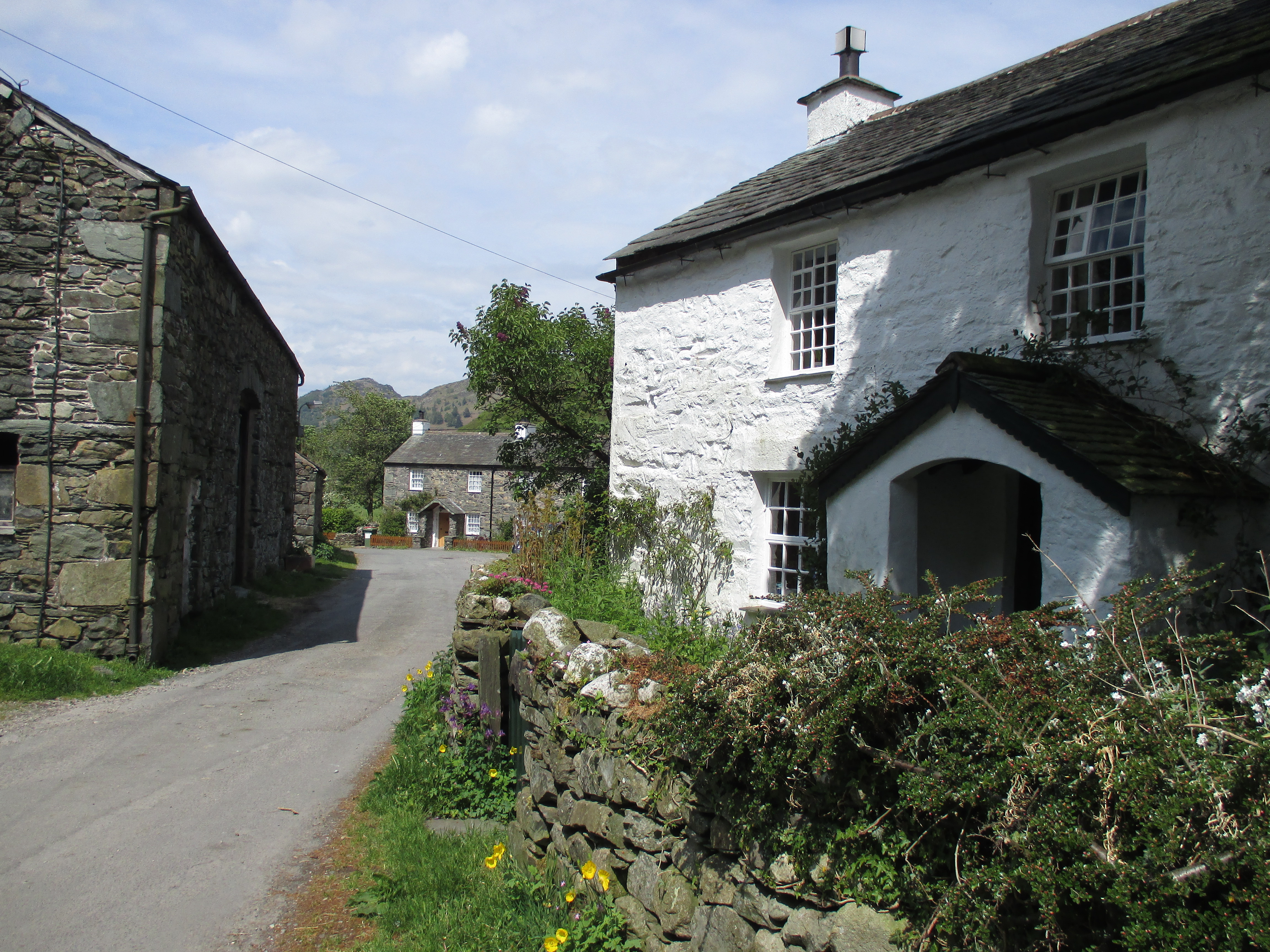
The village of Grange, located in the heart of Borrowdale, serves as a hub for visitors and locals alike. It offers a range of amenities, including accommodation options, pubs, and shops. The village is also known for its charming stone-built cottages and traditional architecture.

Borrowdale is rich in history and heritage, with evidence of human habitation dating back thousands of years. The area is dotted with ancient stone circles, burial mounds, and remnants of old mining activities. The parish also boasts several historic buildings, such as the medieval Bowder Stone and the 17th-century Grange Bridge.

Overall, Borrowdale is a stunning and idyllic location, offering a perfect blend of natural beauty, outdoor activities, and historical charm. It is a must-visit destination for those seeking an authentic Lake District experience.

If you have any feedback on the listing, please let us know in the comments section below.

Borrowdale Images

Images are sourced within 2km of 54.516195/-3.146485 or Grid Reference NY2514. Thanks to Geograph Open Source API. All images are credited.

Rocks and bracken at summit area of High Doat The northward view from the high point of the modest hill, High Doat near to Seatoller in Borrowdale.
Castle Crag lies at the centre of the image with the Skiddaw group in the distance, the highest tops hidden in mist.
Rocks and bracken at summit area of High Doat
The northward view from the high point of the modest hill, High Doat near to Seatoller in Borrowdale. Castle Crag lies at the centre of the image with the Skiddaw group in the distance, the highest tops hidden in mist.
Bracken covered slope descending towards Seatoller The slope is on the minor hill, High Doat, south-west of its summit.
The central, sunlit hill is known as Thornythwaite Fell which has little individual identity and is basically a rising ridge continuing to Glaramara, a summit on the skyline above.
Bracken covered slope descending towards Seatoller
The slope is on the minor hill, High Doat, south-west of its summit. The central, sunlit hill is known as Thornythwaite Fell which has little individual identity and is basically a rising ridge continuing to Glaramara, a summit on the skyline above.
Ford and stepping stones on River Derwent The river crossing just to the west of Rosthwaite.
Ford and stepping stones on River Derwent
The river crossing just to the west of Rosthwaite.
The B5289, Seatoller The main road which passes through Borrowdale and over the Honister Pass. An open-top stagecoach bus sits at its turning point on the edge of Seatoller after an early morning service along the narrow and twisty road from Keswick.
The B5289, Seatoller
The main road which passes through Borrowdale and over the Honister Pass. An open-top stagecoach bus sits at its turning point on the edge of Seatoller after an early morning service along the narrow and twisty road from Keswick.
South from Castle Crag Looking up Borrowdale from Castle Crag, with the relatively low wooded fell, High Doat, in the centre. Glaramara (centre), Great End and Scafell Pike (right) are beyond.
South from Castle Crag
Looking up Borrowdale from Castle Crag, with the relatively low wooded fell, High Doat, in the centre. Glaramara (centre), Great End and Scafell Pike (right) are beyond.
Stonethwaite Beck In spate, downstream of the confluence of Langstrath Beck and Greenup Gill. Eagle Crag is in the background.
Stonethwaite Beck
In spate, downstream of the confluence of Langstrath Beck and Greenup Gill. Eagle Crag is in the background.
Dock Tarn
Dock Tarn
The River Derwent near New Bridge The pebbly bed of the River Derwent under the clear, cold water.
The River Derwent near New Bridge
The pebbly bed of the River Derwent under the clear, cold water.
Chapel House Farm, Borrowdale
New Bridge at Rosthwaite Lovely stone bridge across the River Derwent.
New Bridge at Rosthwaite
Lovely stone bridge across the River Derwent.
Heading into the mist near Castle Crag - and off the planned route, meaning a detour to come!
Heading into the mist near Castle Crag
- and off the planned route, meaning a detour to come!
Quiet moment in Borrowdale The River Derwent beside The Cumbria Way near New Bridge, with Grange Fell in the background.
Quiet moment in Borrowdale
The River Derwent beside The Cumbria Way near New Bridge, with Grange Fell in the background.
Path above Old Mill Cottage On the path from Strands Bridge to Glaramara.
Path above Old Mill Cottage
On the path from Strands Bridge to Glaramara.
Approaching The Combe On the path from Strands Bridge to Glaramara. Ahead is the intake wall and gate into The Combe. On the skyline ahead is Raven Crag and to the left, through the branches of the hawthorn, the pinnacle of Combe Head can be seen.
Approaching The Combe
On the path from Strands Bridge to Glaramara. Ahead is the intake wall and gate into The Combe. On the skyline ahead is Raven Crag and to the left, through the branches of the hawthorn, the pinnacle of Combe Head can be seen.
In The Combe A bunch of Herdwicks are sizing up their visitors.
In The Combe
A bunch of Herdwicks are sizing up their visitors.
Brightly lit rocks of knoll The knoll is one of the features of the higher part of Great Crag above Rosthwaite, in Borrowdale.
Dale Head is the conical peak at the centre of the horizon.
Brightly lit rocks of knoll
The knoll is one of the features of the higher part of Great Crag above Rosthwaite, in Borrowdale. Dale Head is the conical peak at the centre of the horizon.
Sheep movement in Borrowdale Traffic and pedestrians were asked politely to pause for a while as a large flock of sheep was moved from one field to another.
Sheep movement in Borrowdale
Traffic and pedestrians were asked politely to pause for a while as a large flock of sheep was moved from one field to another.
Route of Cumbria Way near to Stonethwaite Stonethwaite is a small settlement on the west side of Stonethwaite Beck; it's bypassed by the Cumbria Way which is on the other side of the stream.
Route of Cumbria Way near to Stonethwaite
Stonethwaite is a small settlement on the west side of Stonethwaite Beck; it's bypassed by the Cumbria Way which is on the other side of the stream.
Show me another place!

Borrowdale is located at Grid Ref: NY2514 (Lat: 54.516195, Lng: -3.146485)

Administrative County: Cumbria

District: Allerdale

Police Authority: Cumbria

What 3 Words

///wiggles.else.finishers. Near Keswick, Cumbria

Related Wikis

Rosthwaite, Borrowdale

Rosthwaite is a settlement in the Borrowdale parish of Cumberland, Cumbria, England. It is also in Borrowdale in the English Lake District to the south...

Stonethwaite

Stonethwaite is a small village in the Lake District in the English county of Cumbria, historically part of Cumberland, it is situated in the valley of...

Great Crag

Great Crag is a fell in the English Lake District, located near the hamlets of Rosthwaite and Stonethwaite in Borrowdale. == Topography == The higher slopes...

Seatoller

Seatoller is a settlement in Borrowdale in the English Lake District. Historically part of Cumberland, it lies on the B5289 road at the east foot of the...

Dock Tarn

Dock Tarn is a small tarn located within the Lake District National Park in Cumbria, England, at grid reference NY273143. It is situated on moorland at...

Borrowdale

Borrowdale is a valley and civil parish in the English Lake District in Cumberland, England. It is in the ceremonial county of Cumbria, and is sometimes...

Stonethwaite Beck

Stonethwaite Beck is a minor river in Cumbria, England. It is a tributary of the River Derwent. Stonethwaite Beck is formed at the confluence of Langstrath...

Castle Crag

Castle Crag is a hill in the North Western Fells of the English Lake District. It is the smallest hill included in Alfred Wainwright's influential Pictorial...

Nearby Amenities

Located within 500m of 54.516195,-3.146485
Barrier: stile
Foot: designated
Lat/Long: 54.5163161/-3.1540219
Barrier: stile
Foot: designated
Lat/Long: 54.5190554/-3.150259
Barrier: stile
Foot: designated
Lat/Long: 54.5193687/-3.150259
Bus Stop
Stonethwaite Road End
Local Ref: AT
Naptan AtcoCode: 090002101377
Naptan Bearing: S
Naptan CommonName: Stonethwaite Road End
Naptan Indicator: at
Naptan Landmark: junction with road to Stonethwaite
Naptan NaptanCode: cumadajd
Naptan Street: B5289
Naptan Verified: yes
Source: naptan_import
Lat/Long: 54.5179222/-3.1483989
Bus Stop
Chapel Howe Road End
Local Ref: AT
Naptan AtcoCode: 090002111360
Naptan Bearing: W
Naptan BusStopType: CUS
Naptan CommonName: Chapel Howe Road End
Naptan Indicator: at
Naptan Landmark: junction of road to Stonethwaite
Naptan NaptanCode: cumadapd
Naptan Street: B5289
Naptan Verified: no
Source: naptan_import
Lat/Long: 54.5177508/-3.1483743
Bus Stop
Longthwaite Road End
Naptan AtcoCode: 090002111375
Naptan Bearing: N
Naptan CommonName: Longthwaite Road End
Naptan Indicator: opp
Naptan Landmark: junction with road to Longthwaite
Naptan NaptanCode: cumadapg
Naptan Street: B5289
Naptan Verified: yes
Source: naptan_import
Lat/Long: 54.5178297/-3.1486744
Bus Stop
Howe Lane End (N bound)
Local Ref: AT
Naptan AtcoCode: 090002111583
Naptan Bearing: N
Naptan CommonName: Howe Lane End (N bound)
Naptan Indicator: at
Naptan Landmark: End of Howe Lane
Naptan NaptanCode: cumadatm
Naptan Street: B5289
Naptan Verified: no
Source: naptan_import
Lat/Long: 54.5206298/-3.147208
Bus Stop
Stonethwaite Village
Bus: yes
Local Ref: IN
Naptan AtcoCode: 090002112947
Naptan Bearing: E
Naptan BusStopType: CUS
Naptan CommonName: Stonethwaite Village
Naptan Indicator: in
Naptan Landmark: Stonethwaite Village
Naptan NaptanCode: cumadgad
Naptan Street: No name
Naptan Verified: no
Public Transport: platform
Source: naptan_import
Lat/Long: 54.5140554/-3.1412802
Bus Stop
Howe Lane End (S bound)
Naptan AtcoCode: 090002113752
Naptan Bearing: S
Naptan CommonName: Howe Lane End (S bound)
Naptan Indicator: opp
Naptan Landmark: junction with lane to Rosthwaite
Naptan NaptanCode: cumadgdg
Naptan Street: Middle Howe
Naptan Verified: no
Source: naptan_import
Lat/Long: 54.5206768/-3.146993
Post Box
Post Box Design: hovis
Post Box Mounting: wall
Post Box Type: lamp
Ref: CA12 234
Royal Cypher: GR
Source: survey
Lat/Long: 54.5136905/-3.1406243
Telephone
Booth: K6
Covered: booth
Listed Status: Grade II
Source: survey
Lat/Long: 54.5137072/-3.1406216
Post Box
Ref: CA12 127
Source: survey
Lat/Long: 54.5177624/-3.1484021
Historic: memorial
Note: World War I memorial
Source: survey
Lat/Long: 54.5163836/-3.1499102
Barrier: stile
Lat/Long: 54.5165387/-3.1508395
Borrowdale
Place: village
Wikidata: Q894164
Wikipedia: en:Borrowdale
Lat/Long: 54.5163359/-3.1470106
Longthwaite
Place: hamlet
Lat/Long: 54.518871/-3.1517881
Access: no
Barrier: stile
Foot: yes
Lat/Long: 54.5162587/-3.1452742
Give Way
Direction: forward
Lat/Long: 54.5204997/-3.1471235
Leisure: picnic_table
Lat/Long: 54.5178726/-3.1518958
Bicycle Parking
Capacity: 10
Covered: yes
Note: Ask at reception for access
Lat/Long: 54.5180015/-3.1527168
Leisure: picnic_table
Lat/Long: 54.5178754/-3.1520384
Restaurant
Borrowdale YHA
Lat/Long: 54.5180836/-3.1523826
Leisure: picnic_table
Lat/Long: 54.517787/-3.1521055
Bench
Lat/Long: 54.5177933/-3.1519245
Cafe
Borrowdale YHA
Lat/Long: 54.5178848/-3.1524634
Drinking Water
Lat/Long: 54.5179234/-3.1523992
Tram Dub
Place: locality
Lat/Long: 54.5206479/-3.146497
Barrier: stile
Lat/Long: 54.515718/-3.151368
Ford: yes
Lat/Long: 54.5156475/-3.1536392
Power: pole
Lat/Long: 54.5185418/-3.1517803
Power: pole
Lat/Long: 54.5189576/-3.1507534
The data included in this document is from www.openstreetmap.org. The data is made available under ODbL.

Have you been to Borrowdale?

Leave your review of Borrowdale below (or comments, questions and feedback).