Blakemere

Civil Parish in Herefordshire

England

Blakemere

War Memorial, Moccas Situated in Moccas at the crossroads on the B4352.
War Memorial, Moccas Credit: Stuart Wilding

Blakemere is a civil parish located in Herefordshire, England. It is situated approximately 3 miles southeast of the market town of Hereford. The parish covers an area of around 3.5 square miles and is home to a small population of residents.

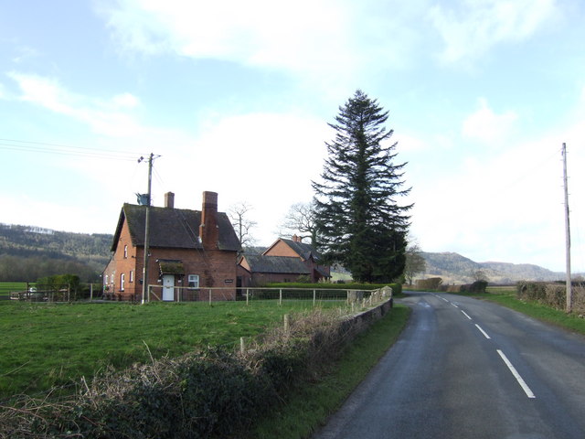
The landscape of Blakemere is predominantly rural, characterized by rolling hills, open fields, and scattered farms. The area is known for its picturesque countryside, offering beautiful views and ample opportunities for outdoor activities such as walking, hiking, and cycling.

The parish is dotted with several historic buildings, including Blakemere Court, a Grade II listed Georgian country house dating back to the early 19th century. The house boasts elegant architectural features and is surrounded by well-maintained gardens, adding to the charm of the area.

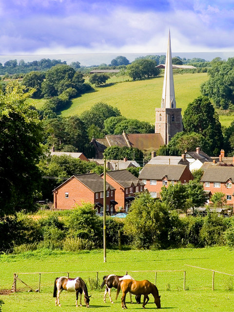
Blakemere is also home to a quaint village church, St. Leonard's Church, which dates back to the 13th century. The church is a notable landmark in the area, with its striking medieval architecture and a peaceful graveyard.

The parish is well-connected to the surrounding areas, with good transport links and easy access to nearby towns and cities. It offers a peaceful and idyllic setting for those seeking a rural lifestyle, while still providing convenience with its proximity to Hereford.

Overall, Blakemere is a charming civil parish in Herefordshire, offering a tranquil countryside setting, historic buildings, and a strong sense of community.

If you have any feedback on the listing, please let us know in the comments section below.

Blakemere Images

Images are sourced within 2km of 52.061974/-2.929987 or Grid Reference SO3640. Thanks to Geograph Open Source API. All images are credited.

War Memorial, Moccas Situated in Moccas at the crossroads on the B4352.
War Memorial, Moccas
Situated in Moccas at the crossroads on the B4352.
Orchard, Bycross Originally called Bycross Ferry, with the loss of the ferry it's now simply Bycross. (The River Wye is behind the trees, hence the ferry)
Orchard, Bycross
Originally called Bycross Ferry, with the loss of the ferry it's now simply Bycross. (The River Wye is behind the trees, hence the ferry)
Bridleway across a field near Greenway Farm The bridleway follows the high ground to the east of Greenway Farm and above Greenway Wood.
Bridleway across a field near Greenway Farm
The bridleway follows the high ground to the east of Greenway Farm and above Greenway Wood.
Farm Building, Greenway Farm This farm building is at the rear of Greenway Farm in the extreme bottom south-east of the grid square.
Farm Building, Greenway Farm
This farm building is at the rear of Greenway Farm in the extreme bottom south-east of the grid square.
Crop Spraying Crop spraying a field near Greenway Farm.
Crop Spraying
Crop spraying a field near Greenway Farm.
St Leonard's church, Blakemere.
North Lodge of Tyberton Court Pictured from the B4352 looking west.
North Lodge of Tyberton Court
Pictured from the B4352 looking west.
Cottage at Holywell This cottage on a bend in the lane heading towards Blakemore is in the hamlet of Holywell.
Cottage at Holywell
This cottage on a bend in the lane heading towards Blakemore is in the hamlet of Holywell.
B4352 south of Blakemere
Muddy track near Blakemere
Woodbury Hill Wood The ridge which terminates at Merbach Hill is mostly wooded on this northern side.
Woodbury Hill Wood
The ridge which terminates at Merbach Hill is mostly wooded on this northern side.
Mistletoe harvest An old cider orchard at Woodbury Farm yields a sustainable cash-crop at this time of year.
Mistletoe harvest
An old cider orchard at Woodbury Farm yields a sustainable cash-crop at this time of year.
Mistletoe harvest - closer shot The farmer and his dog at work bundling up the mistletoe for market in Birmingham.
Mistletoe harvest - closer shot
The farmer and his dog at work bundling up the mistletoe for market in Birmingham.
Young cider orchard A relatively new planting at Woodbury Farm, Moccas, Herefordshire.
Young cider orchard
A relatively new planting at Woodbury Farm, Moccas, Herefordshire.
Sheep in the cider orchard View south of Moccas crossroads, with Woodbury Hill Woods in the background.
Sheep in the cider orchard
View south of Moccas crossroads, with Woodbury Hill Woods in the background.
St Leonard's, Blakemere
St Leonards Church, Blakemere Blakemere Church
St Leonards Church, Blakemere
Blakemere Church
Moccas, war memorial On B4352, looking towards Moccas Court; recording the names of 4 fatalities in WW1.
Moccas, war memorial
On B4352, looking towards Moccas Court; recording the names of 4 fatalities in WW1.
Show me another place!

Blakemere is located at Grid Ref: SO3640 (Lat: 52.061974, Lng: -2.929987)

Unitary Authority: County of Herefordshire

Police Authority: West Mercia

What 3 Words

///hired.dwelled.manifests. Near Tyberton, Herefordshire

Nearby Locations

Blakemere

Related Wikis

Blakemere

Blakemere is a parish in Herefordshire, England. It is 11 miles west of Hereford, on the road to Hay-on-Wye. == External links == Media related to Blakemere...

Preston on Wye

Preston on Wye is a village and civil parish in Herefordshire, England. It is situated near the River Wye, about 9 miles west of Hereford. Nearby places...

Tyberton

Tyberton or Tiberton is a village and civil parish 8 miles (13 km) west of Hereford, in the county of Herefordshire, England. In 2011 the parish had a...

Moccas

Moccas is a village and civil parish in the English county of Herefordshire. It is located 14 miles (23 km) west of Hereford. The population of the civil...

Moccas Monastery

Moccas Monastery was an early mediaeval monastery near Moccas in Herefordshire, England at grid reference SO35654327. Neither the foundation nor dissolution...

Peterchurch

Peterchurch is a village and civil parish in the Golden Valley, Herefordshire, England. The countryside around is spectacular, with views of the Black...

Moccas Court

Moccas Court is an 18th-century country house which sits in sloping grounds overlooking the River Wye north of the village of Moccas, Herefordshire, England...

Monnington on Wye

Monnington on Wye is a village and former civil parish, now in the parish of Brobury with Monnington-on-Wye, in western Herefordshire, England, located...

Nearby Amenities

Located within 500m of 52.061974,-2.929987
Bus Stop
Church
Naptan AtcoCode: 2090A150400
Naptan Bearing: SE
Naptan BusStopType: CUS
Naptan CommonName: Church
Naptan Indicator: opp
Naptan Landmark: Church
Naptan NaptanCode: heragjmt
Naptan Street: B4352
Naptan Verified: no
Source: naptan_import
Lat/Long: 52.0648837/-2.9317205
Bus Stop
Church
Naptan AtcoCode: 2090A150401
Naptan Bearing: NW
Naptan BusStopType: CUS
Naptan CommonName: Church
Naptan Indicator: adj
Naptan Landmark: Church
Naptan NaptanCode: heragjmw
Naptan Street: B4352
Naptan Verified: no
Source: naptan_import
Lat/Long: 52.0648708/-2.9319747
Post Box
Collection Times: Mo-Fr 12:00, Sa 08:30
Operator: Royal Mail
Ref Signed: no
Royal Cypher: EIIR
Royal Cypher Wikidata: Q33102113
Lat/Long: 52.0636216/-2.930471
Blakemere
Place: village
Wikidata: Q3784245
Lat/Long: 52.0652334/-2.9321049
Bench
Backrest: yes
Colour: blue
Material: wood
Seats: 2
Lat/Long: 52.0652959/-2.9323036
Generator Method: photovoltaic
Generator Output Electricity: yes
Generator Source: solar
Generator Type: solar_photovoltaic_panel
Location: ground
Power: generator
Lat/Long: 52.0662641/-2.9311743
Generator Method: photovoltaic
Generator Output Electricity: yes
Generator Source: solar
Generator Type: solar_photovoltaic_panel
Location: ground
Power: generator
Lat/Long: 52.0639226/-2.9321802
Power: pole
Lat/Long: 52.0652781/-2.926333
Power: pole
Lat/Long: 52.0640381/-2.9300451
Power: pole
Lat/Long: 52.0645938/-2.9282776
Power: pole
Lat/Long: 52.0621945/-2.927269
Power: pole
Lat/Long: 52.0613518/-2.9269525
Power: pole
Lat/Long: 52.0604761/-2.9265958
Power: pole
Lat/Long: 52.0596714/-2.9262847
Power: pole
Lat/Long: 52.059137/-2.9260299
Power: pole
Lat/Long: 52.0628458/-2.9311314
Power: pole
Lat/Long: 52.0616288/-2.9302704
Power: pole
Lat/Long: 52.0611407/-2.9293987
Power: pole
Lat/Long: 52.064602/-2.9334784
Power: pole
Lat/Long: 52.0643266/-2.9346854
Power: pole
Lat/Long: 52.0654931/-2.9339792
Power: pole
Lat/Long: 52.0657084/-2.9334301
Power: pole
Lat/Long: 52.0652814/-2.9345191
Power: pole
Lat/Long: 52.0647174/-2.9345915
Power: pole
Lat/Long: 52.063639/-2.9347846
Power: pole
Lat/Long: 52.0622192/-2.9343581
Power: pole
Lat/Long: 52.0617954/-2.9323626
Power: pole
Lat/Long: 52.0629811/-2.9276097
Power: pole
Lat/Long: 52.0627469/-2.9285243
Power: pole
Lat/Long: 52.0622406/-2.9306835
Power: pole
Lat/Long: 52.0613864/-2.9340899
Power: pole
Lat/Long: 52.0610401/-2.9364556
Telephone
Defibrillator
Booth: K6
Covered: booth
Defibrillator Location: inside red phone box in Blakemere
Emergency: defibrillator
Man Made: telephone_box
Lat/Long: 52.0613941/-2.9291865
The data included in this document is from www.openstreetmap.org. The data is made available under ODbL.

Have you been to Blakemere?

Leave your review of Blakemere below (or comments, questions and feedback).