Bewick

Civil Parish in Northumberland

England

Bewick

Plantation on Eglingham Moor Most of this part of the moor is rough grassland but there is this one rectangular conifer plantation, with Bewick Hill beyond.
Plantation on Eglingham Moor Credit: Stephen Craven

Bewick is a civil parish located in the county of Northumberland, England. It is situated in the northern part of the county, near the border with Scotland. The parish covers an area of approximately 8 square miles and has a population of around 200 residents.

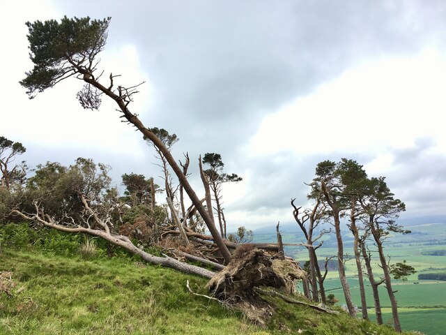
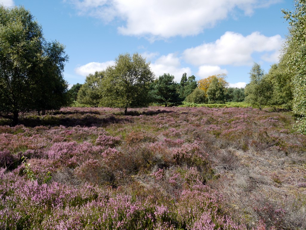
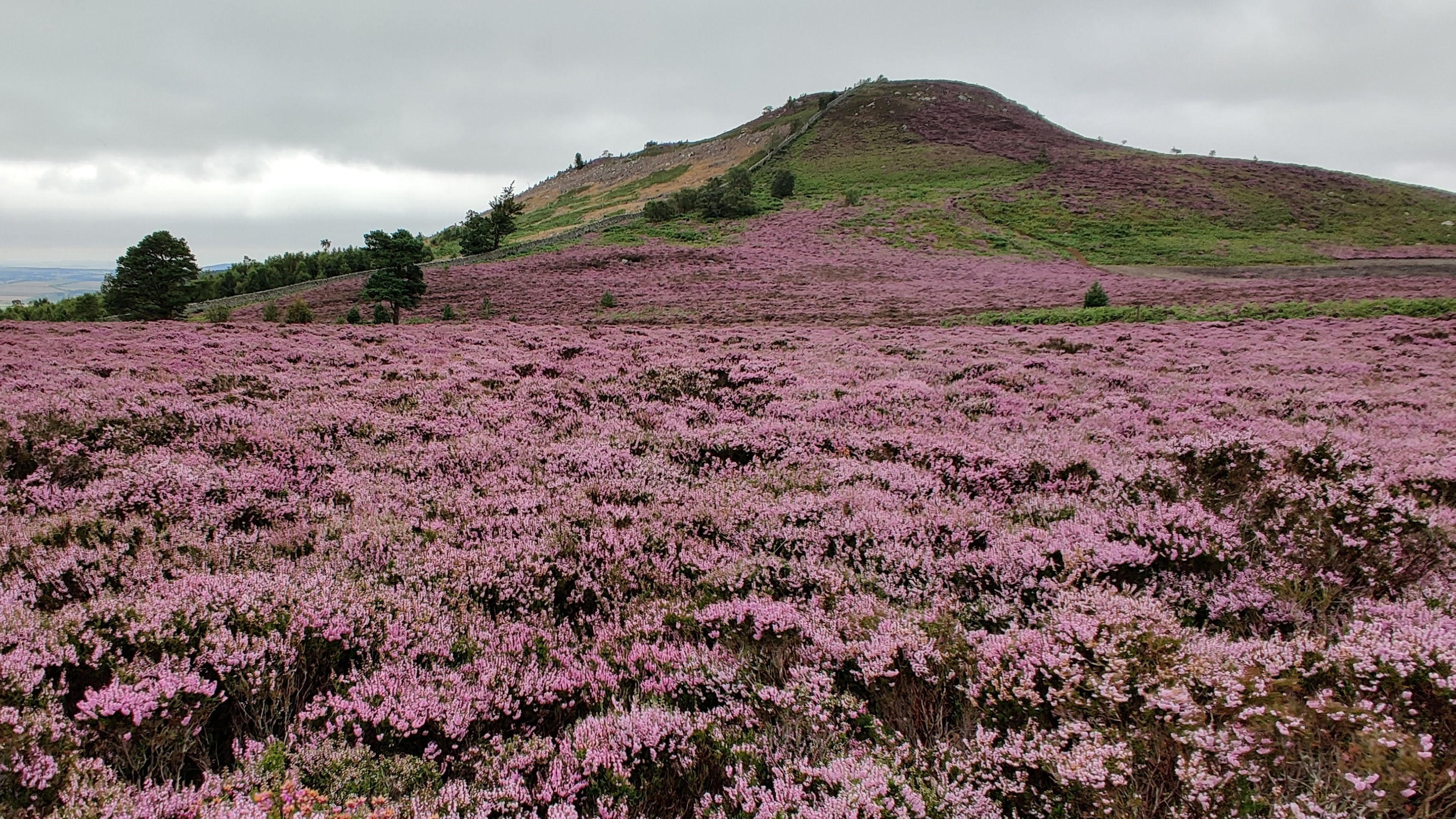
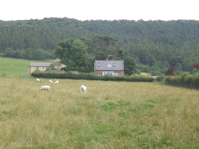
The landscape of Bewick is characterized by rolling hills and picturesque countryside, offering stunning views of the surrounding area. It is primarily an agricultural area, with farming being the main occupation of the local community. The fertile land is used for the cultivation of crops and the rearing of livestock.

The parish is home to several small hamlets and scattered settlements, with the main village being Bewick itself. The village features a mix of traditional stone-built houses and modern dwellings, creating a charming and welcoming atmosphere. It has a small community hall, a church, and a primary school, providing essential amenities for the local population.

Bewick is a popular destination for outdoor enthusiasts due to its proximity to the Cheviot Hills and Northumberland National Park. The area offers numerous opportunities for hiking, cycling, and wildlife watching. Visitors can explore the vast expanses of unspoiled countryside, encounter diverse flora and fauna, and enjoy the tranquility of the natural surroundings.

Overall, Bewick, Northumberland is a rural parish with a close-knit community, stunning natural beauty, and a rich agricultural heritage. It offers a peaceful and idyllic setting for both residents and visitors alike.

If you have any feedback on the listing, please let us know in the comments section below.

Bewick Images

Images are sourced within 2km of 55.494039/-1.858577 or Grid Reference NU0922. Thanks to Geograph Open Source API. All images are credited.

Plantation on Eglingham Moor Most of this part of the moor is rough grassland but there is this one rectangular conifer plantation, with Bewick Hill beyond.
Plantation on Eglingham Moor
Most of this part of the moor is rough grassland but there is this one rectangular conifer plantation, with Bewick Hill beyond.
Another wood ravaged by Storm Arwen Judging by the satellite images this rectangular wood was quite a dense plantation.  Its exposed position left it vulnerable to the storm although, curiously, rather than being blown over or snapped, many of its trees appear to have had their branches removed.
Another wood ravaged by Storm Arwen
Judging by the satellite images this rectangular wood was quite a dense plantation. Its exposed position left it vulnerable to the storm although, curiously, rather than being blown over or snapped, many of its trees appear to have had their branches removed.
Bridleway heading towards plantation The trees are on moorland south-east of Cateran Hill, they're in the shape of a parallelogram, a rhombus, even! The path's line doesn't quite match the route as indicated by OS mapping.
Bridleway heading towards plantation
The trees are on moorland south-east of Cateran Hill, they're in the shape of a parallelogram, a rhombus, even! The path's line doesn't quite match the route as indicated by OS mapping.
Site of Leper Hospital The Knights of St Lazarus are reputed to have established a leper hospital here in the Twelfth Century.  The only physical remains now may be the stone bath visible on the hillside just below the white bull.  See 

 <span class="nowrap"><a title="https://ora.ox.ac.uk/objects/uuid:f0b91cef-4737-4664-b3f3-a296cc3a0bba/download_file?file_format=pdf&safe_filename=Harehope%2Band%2BSt%2BLazarus%2Brevised%2Bversion.pdf&type_of_work=Journal+article" rel="nofollow ugc noopener" href="https://ora.ox.ac.uk/objects/uuid:f0b91cef-4737-4664-b3f3-a296cc3a0bba/download_file?file_format=pdf&safe_filename=Harehope%2Band%2BSt%2BLazarus%2Brevised%2Bversion.pdf&type_of_work=Journal+article">Link</a><img style="margin-left:2px;" alt="External link" title="External link - shift click to open in new window" src="https://s1.geograph.org.uk/img/external.png" width="10" height="10"/></span>  

<span class="nowrap"><a title="https://keystothepast.info/search-records/results-of-search/results-of-search-2/site-details/?PRN=N3618" rel="nofollow ugc noopener" href="https://keystothepast.info/search-records/results-of-search/results-of-search-2/site-details/?PRN=N3618">Link</a><img style="margin-left:2px;" alt="External link" title="External link - shift click to open in new window" src="https://s1.geograph.org.uk/img/external.png" width="10" height="10"/></span>

<a href="https://www.geograph.org.uk/photo/5265044">NU0920 : Neolithic hot tub . . .  or DIY sheep dip tank?</a>
Site of Leper Hospital
The Knights of St Lazarus are reputed to have established a leper hospital here in the Twelfth Century. The only physical remains now may be the stone bath visible on the hillside just below the white bull. See LinkExternal link LinkExternal link NU0920 : Neolithic hot tub . . . or DIY sheep dip tank?
Storm Arwen at Hanging Crag The storm took its toll of this small stand of pine trees.  The exposure that made it such a landmark was also its undoing.  It used to look like

<a href="https://www.geograph.org.uk/photo/477395">NU0721 : Hanging Crag</a>
Storm Arwen at Hanging Crag
The storm took its toll of this small stand of pine trees. The exposure that made it such a landmark was also its undoing. It used to look like NU0721 : Hanging Crag
Circular stone trough This trough, carved in the bedrock, is about 1.5m in diameter and 0.3m deep.  It's now filled with earth and weeds but 13 years ago it was almost empty.  It's almost at the centre-point of the semicircle that forms the eastern hill fort.  I have no definite idea of its purpose; a water tank perhaps?  Pillbox in the background.  See also

<a href="https://www.geograph.org.uk/photo/7349111">NU0721 : Circular stone trough</a>
Circular stone trough
This trough, carved in the bedrock, is about 1.5m in diameter and 0.3m deep. It's now filled with earth and weeds but 13 years ago it was almost empty. It's almost at the centre-point of the semicircle that forms the eastern hill fort. I have no definite idea of its purpose; a water tank perhaps? Pillbox in the background. See also NU0721 : Circular stone trough
Circular stone trough This trough, carved in the bedrock, is about 1.5m in diameter and 0.3m deep.  It's almost at the centre-point of the semicircle that forms the eastern hill fort.  I have no definite idea of its purpose; a water tank perhaps?  See also

<a href="https://www.geograph.org.uk/photo/7349102">NU0721 : Circular stone trough</a>
Circular stone trough
This trough, carved in the bedrock, is about 1.5m in diameter and 0.3m deep. It's almost at the centre-point of the semicircle that forms the eastern hill fort. I have no definite idea of its purpose; a water tank perhaps? See also NU0721 : Circular stone trough
Millstone on Harehope Hill Abandoned on its journey from quarry to mill?
Millstone on Harehope Hill
Abandoned on its journey from quarry to mill?
Millstone on Harehope Hill Abandoned on its journey from quarry to mill?
Millstone on Harehope Hill
Abandoned on its journey from quarry to mill?
Hill at 279 metres, east of Hepburn Wood The moorland hill is given no name on OS maps. Its eastern side is seen in the image from a location just north of a bridleway north-west of Castle Hill.
Hill at 279 metres, east of Hepburn Wood
The moorland hill is given no name on OS maps. Its eastern side is seen in the image from a location just north of a bridleway north-west of Castle Hill.
Path through valley of Harehope Burn The Harehope Burn is the main stream draining the southern part of the low-level moorland area north of Eglingham. South-east of the ruins at  Blawearie it enters a rocky passage where a path has been created involving stretches of boardwalk and bridges of the sort seen in the image. There's a small amount of easy scrambling needed as well. The route isn't a public footpath but it's entirely over access land.
Path through valley of Harehope Burn
The Harehope Burn is the main stream draining the southern part of the low-level moorland area north of Eglingham. South-east of the ruins at Blawearie it enters a rocky passage where a path has been created involving stretches of boardwalk and bridges of the sort seen in the image. There's a small amount of easy scrambling needed as well. The route isn't a public footpath but it's entirely over access land.
Wall and tracks rising to Nun Law Nun Law is a minor feature of the low-level moorland of Bewick Moor. The tracks have been created by the passage of vehicles and will be concerned with the shoot which operates on the estate.
Wall and tracks rising to Nun Law
Nun Law is a minor feature of the low-level moorland of Bewick Moor. The tracks have been created by the passage of vehicles and will be concerned with the shoot which operates on the estate.
Hanging Crag
Hanging Crag
Cateran Hole Cateran Hole on Quarryhouse Moor
Cateran Hole
Cateran Hole on Quarryhouse Moor
Cairn on heather moorland The cairn is on a knoll just north of the summit of Cateran Hill, where there's another. The cloud-shadowed hill in the distance is Ros Hill, the location of an Iron Age Fort.
Cairn on heather moorland
The cairn is on a knoll just north of the summit of Cateran Hill, where there's another. The cloud-shadowed hill in the distance is Ros Hill, the location of an Iron Age Fort.
In Cateran Hole A view towards the daylight seeping into Cateran Hole.  

Cateran Hole is a near 40 metre long cave formed in Fell Sandstone from fractures being widened.  The cave drops to a depth of nearly nine metres and is accessed via six stone steps from the bleak moorland above.


For a full description of Cateran Hole, see G J Mullan's paper from the proceedings of the University of Bristol Speleological Society at <span class="nowrap"><a title="http://www.ubss.org.uk/resources/proceedings/vol18/UBSS_Proc_18_3_430-437.pdf" rel="nofollow ugc noopener" href="http://www.ubss.org.uk/resources/proceedings/vol18/UBSS_Proc_18_3_430-437.pdf">Link</a><img style="margin-left:2px;" alt="External link" title="External link - shift click to open in new window" src="https://s1.geograph.org.uk/img/external.png" width="10" height="10"/></span>
In Cateran Hole
A view towards the daylight seeping into Cateran Hole. Cateran Hole is a near 40 metre long cave formed in Fell Sandstone from fractures being widened. The cave drops to a depth of nearly nine metres and is accessed via six stone steps from the bleak moorland above. For a full description of Cateran Hole, see G J Mullan's paper from the proceedings of the University of Bristol Speleological Society at LinkExternal link
35 metres inside Cateran Hole Just prior to where a crawl in mud deposits would be necessary to reach the furthest extent of the cave.
35 metres inside Cateran Hole
Just prior to where a crawl in mud deposits would be necessary to reach the furthest extent of the cave.
Show me another place!

Bewick is located at Grid Ref: NU0922 (Lat: 55.494039, Lng: -1.858577)

Unitary Authority: Northumberland

Police Authority: Northumbria

What 3 Words

///cabinet.thinking.awestruck. Near Ellingham, Northumberland

Related Wikis

Bewick and Beanley Moors

Bewick and Beanley Moors is the name given to a Site of Special Scientific Interest (SSSI) in north Northumberland, in the north-east of England. The moors...

Cateran Hole

Cateran Hole is a circa 35m length cave set in the Gritstone of Cateran Hill in Northumberland. It lies about 4 miles due north of Eglingham, and can be...

Old Bewick

Old Bewick is a rural village and former civil parish, now in the parish of Bewick, in the county of Northumberland, England, notable for its Bronze Age...

Bewick, Northumberland

Bewick () is a civil parish in the county of Northumberland, England. In 2001 it had a population of 69, increasing to 138 (after the inclusion of Chillingham...

Eglingham Hall

Eglingham Hall (grid reference NU10421954) is a former mansion house and a Grade II* listed building situated at Eglingham, near Alnwick, Northumberland...

Eglingham

Eglingham is a village in Northumberland, England, situated about 7 miles (11 km) north-west of Alnwick and 10 miles (16 km) from Wooler. It lies in the...

Ros Hill

Ros Hill, also known as Ros Castle due to the 3,000-year-old Iron Age hill fort on its summit, is a hill in the county of Northumberland in northern England...

Hepburn, Northumberland

Hepburn is a hamlet and former civil parish, now in the civil parish of Chillingham in the county of Northumberland, England. The civil parish was merged...

Nearby Amenities

Located within 500m of 55.494039,-1.858577
Castle Hill
Ele: 242
Natural: peak
Lat/Long: 55.4959883/-1.85224
Corbie Crags
Place: locality
Lat/Long: 55.4900055/-1.861272
Dove Crags
Place: locality
Lat/Long: 55.4962149/-1.8584456
The data included in this document is from www.openstreetmap.org. The data is made available under ODbL.

Have you been to Bewick?

Leave your review of Bewick below (or comments, questions and feedback).