Bere Ferrers

Civil Parish in Devon West Devon

England

Bere Ferrers

Signpost at Bere Alston The post is in a classic Devon County Council style and directions are given to the railway station (via Station Road) and two farmsteads - Braunder and Helstone via a very minor road. Helstone is marked as Helston Farm on Ordnance Survey maps.
Signpost at Bere Alston Credit: Stephen McKay

Bere Ferrers is a civil parish located in the county of Devon, England. Situated on the western bank of the River Tavy, it forms part of the West Devon district. The parish covers an area of approximately 17 square kilometers and is home to a population of around 1,200 residents.

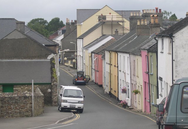
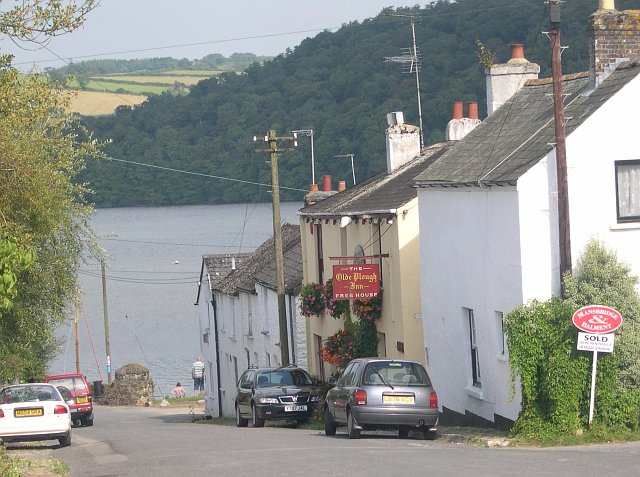
The village of Bere Ferrers is the main settlement within the parish. It is a picturesque and historic village, known for its rural charm and scenic beauty. The village features a number of traditional thatched cottages and historic buildings, including St. Andrew's Church, which dates back to the 13th century.

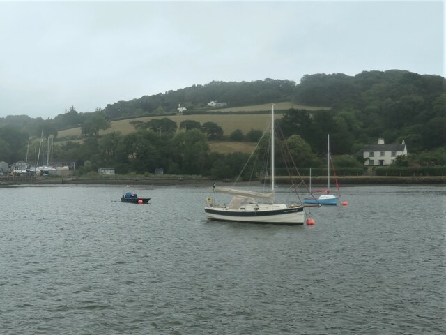
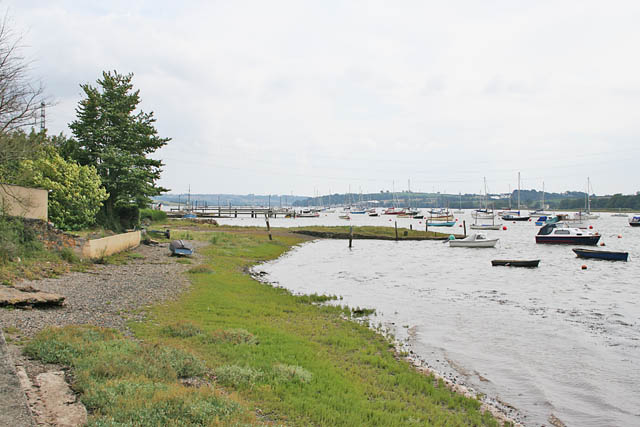
The surrounding countryside of Bere Ferrers offers a range of outdoor activities and natural attractions. The Tamar Valley Area of Outstanding Natural Beauty is nearby, providing stunning landscapes and opportunities for hiking, cycling, and wildlife watching. The River Tavy also offers opportunities for boating and fishing.

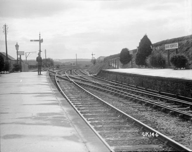
In terms of amenities, Bere Ferrers has a village hall, a primary school, and a local pub, which serves as a social hub for the community. The village is well-connected to other parts of Devon by road and rail, with Bere Ferrers railway station providing regular services to Plymouth and other nearby towns.

Overall, Bere Ferrers is a charming and idyllic rural parish in Devon, offering a peaceful and picturesque setting for its residents and visitors alike.

If you have any feedback on the listing, please let us know in the comments section below.

Bere Ferrers Images

Images are sourced within 2km of 50.469344/-4.187111 or Grid Reference SX4465. Thanks to Geograph Open Source API. All images are credited.

Signpost at Bere Alston The post is in a classic Devon County Council style and directions are given to the railway station (via Station Road) and two farmsteads - Braunder and Helstone via a very minor road. Helstone is marked as Helston Farm on Ordnance Survey maps.
Signpost at Bere Alston
The post is in a classic Devon County Council style and directions are given to the railway station (via Station Road) and two farmsteads - Braunder and Helstone via a very minor road. Helstone is marked as Helston Farm on Ordnance Survey maps.
H & A Sleep, Bere Alston H & A Sleep offers MOTs, vehicle servicing and general repairs from this garage on the edge of Bere Alston village. It was firmly closed on this bank holiday Monday, however. The sign also refers to 'coach hire' although this aspect of the business appears to be defunct. In fact, at one time the company ran a local bus service between Bere Alston and Tavistock - in 1975 this comprised four return trips each weekday with extras on Fridays (the telephone number was then listed as Bere Alston 244).
H & A Sleep, Bere Alston
H & A Sleep offers MOTs, vehicle servicing and general repairs from this garage on the edge of Bere Alston village. It was firmly closed on this bank holiday Monday, however. The sign also refers to 'coach hire' although this aspect of the business appears to be defunct. In fact, at one time the company ran a local bus service between Bere Alston and Tavistock - in 1975 this comprised four return trips each weekday with extras on Fridays (the telephone number was then listed as Bere Alston 244).
Bench and planter - Bere Alston The bench is located at the junction of Station Road and Broad Park Road. The trousers and wellies make for a fun touch.
Bench and planter - Bere Alston
The bench is located at the junction of Station Road and Broad Park Road. The trousers and wellies make for a fun touch.
J A N Brown, Bere Alston This traditional-looking grocery store is located on Station Road, a short distance from the village Co-op which presumably provides some stiff competition. The window includes various advertisements for local services.
J A N Brown, Bere Alston
This traditional-looking grocery store is located on Station Road, a short distance from the village Co-op which presumably provides some stiff competition. The window includes various advertisements for local services.
Bere Alston War Memorial and Parish Hall The grade II listed granite war memorial stands in front of the Parish Hall. It commemorates 42  local men who died in the First World War and on the tablet below a further 21 who lost their lives in the Second World War. To the rear (out of shot) the names of ten New Zealand servicemen who were killed in an accident at Bere Ferrers station in 1917 are inscribed. The memorial was unveiled in July 1921.
Bere Alston War Memorial and Parish Hall
The grade II listed granite war memorial stands in front of the Parish Hall. It commemorates 42 local men who died in the First World War and on the tablet below a further 21 who lost their lives in the Second World War. To the rear (out of shot) the names of ten New Zealand servicemen who were killed in an accident at Bere Ferrers station in 1917 are inscribed. The memorial was unveiled in July 1921.
Fore Street, Bere Alston Bere Alston is the principal settlement on the Bere Peninsula, a spit of land between the Rivers Tamar and Tavy. Its heart is Fore Street, seen here from outside the Edgcumbe Hotel.
Fore Street, Bere Alston
Bere Alston is the principal settlement on the Bere Peninsula, a spit of land between the Rivers Tamar and Tavy. Its heart is Fore Street, seen here from outside the Edgcumbe Hotel.
Fore Street, Bere Alston This is the northern end of Fore Street with Bedford Street leading off to the right and Station Road to the left. On the immediate left is Bere Peninsula Pharmacy which has lost part of its sign.
Fore Street, Bere Alston
This is the northern end of Fore Street with Bedford Street leading off to the right and Station Road to the left. On the immediate left is Bere Peninsula Pharmacy which has lost part of its sign.
Johnson Close, Bere Alston A cat glances back at the photographer at the pedestrianised end of Johnson Close where it meets Station Road. The street may have been named after a Percival Johnson, founder of the Tamar Smelting Works (which existed for some years in the 19th century) and a social reformer. The houses date from around 1970.
Johnson Close, Bere Alston
A cat glances back at the photographer at the pedestrianised end of Johnson Close where it meets Station Road. The street may have been named after a Percival Johnson, founder of the Tamar Smelting Works (which existed for some years in the 19th century) and a social reformer. The houses date from around 1970.
Yachts moored near Cleave Farm On the tidal River Tamar. The rising tide makes the boats point downstream.
Yachts moored near Cleave Farm
On the tidal River Tamar. The rising tide makes the boats point downstream.
Weir Quay boatyard On the east [Devon] bank of the River Tamar.
Weir Quay boatyard
On the east [Devon] bank of the River Tamar.
Riverside houses between Hole's Hole and Weir Quay On the east [Devon] bank of the River Tamar.
Riverside houses between Hole's Hole and Weir Quay
On the east [Devon] bank of the River Tamar.
Liphill Quay (low tide) Slipway into Liphill Creek, at low tide. Public footpath Bere Ferrers 83 passes above the slipway and along the foreshore. A similar view visible at high tide in high summer: <a href="https://www.geograph.org.uk/photo/326986">SX4463 : Pointing the right of way.</a>.
Liphill Quay (low tide)
Slipway into Liphill Creek, at low tide. Public footpath Bere Ferrers 83 passes above the slipway and along the foreshore. A similar view visible at high tide in high summer: SX4463 : Pointing the right of way..
Footpath to Tuckham Bridge Bere Ferrers public footpath 83 between Tuckham Bridge and Liphill Quay, below Little Clamoak Farm. Much work had been done here to lop overhanging vegetation along the field margin, presumably to let more light into the carr below the field. Compare with <a href="https://www.geograph.org.uk/photo/326975">SX4464 : Footpath along the Valley Bottom</a> taken in the vicinity.
Footpath to Tuckham Bridge
Bere Ferrers public footpath 83 between Tuckham Bridge and Liphill Quay, below Little Clamoak Farm. Much work had been done here to lop overhanging vegetation along the field margin, presumably to let more light into the carr below the field. Compare with SX4464 : Footpath along the Valley Bottom taken in the vicinity.
Lane from Cotts to Clamoak Quarry On the ascent from Clamoak Quarry. See <a href="https://www.geograph.org.uk/photo/2338166">SX4464 : Birch Wood valley</a> for the view from the gate.
Lane from Cotts to Clamoak Quarry
On the ascent from Clamoak Quarry. See SX4464 : Birch Wood valley for the view from the gate.
Birch Wood valley View up the Birch Wood valley from the minor unsurfaced road just above Clamoak Quarry. The viewpoint is the gate in the <a href="https://www.geograph.org.uk/photo/2338159">SX4464 : Lane from Cotts to Clamoak Quarry</a>.
Birch Wood valley
View up the Birch Wood valley from the minor unsurfaced road just above Clamoak Quarry. The viewpoint is the gate in the SX4464 : Lane from Cotts to Clamoak Quarry.
Ascent alongside Clamoak Poll Wood Continuing the ascent from Clamoak Quarry, alongside (on the map) Clamoak Poll Wood: the wood is shown on maps as occupying the east side of the road, but has retreated by around 25-50m.
Ascent alongside Clamoak Poll Wood
Continuing the ascent from Clamoak Quarry, alongside (on the map) Clamoak Poll Wood: the wood is shown on maps as occupying the east side of the road, but has retreated by around 25-50m.
At the top The summit of the ascent from Clamoak Quarry, at the 95m contour. Even quite recent maps (late 1970s) show a footpath from opposite the gate down to Tuckham Bridge, which would have provided a shorter route on foot compared to the shallow gradient of the lane.
At the top
The summit of the ascent from Clamoak Quarry, at the 95m contour. Even quite recent maps (late 1970s) show a footpath from opposite the gate down to Tuckham Bridge, which would have provided a shorter route on foot compared to the shallow gradient of the lane.
Towards Lower Birch Farm A modest descent from the summit towards Lower Birch Farm and the crossroads at Lower Birch, which is at 76m.
Towards Lower Birch Farm
A modest descent from the summit towards Lower Birch Farm and the crossroads at Lower Birch, which is at 76m.
Show me another place!

Bere Ferrers is located at Grid Ref: SX4465 (Lat: 50.469344, Lng: -4.187111)

Administrative County: Devon

District: West Devon

Police Authority: Devon & Cornwall

What 3 Words

///endlessly.reform.happening. Near Bere Alston, Devon

Related Wikis

Weir Quay

Weir Quay is a place on the banks of the River Tamar in Devon, England. It lies 1 mile (1.6 km) south west of the village of Bere Alston. Weir Quay is...

Bere Alston

Bere Alston is a village in West Devon in the county of Devon in England. It forms part of the civil parish of Bere Ferrers. == History and geography... ==

Bere Alston railway station

Bere Alston railway station serves the village of Bere Alston in Devon, England, 10+1⁄4 miles (16.5 km) north of Plymouth on the Tamar Valley Line to Gunnislake...

Bere Ferrers rail accident

The Bere Ferrers rail accident occurred at Bere Ferrers railway station in England on 24 September 1917 when ten soldiers from New Zealand alighted from...

Bere Ferrers

Bere Ferrers, sometimes called Beerferris, is a village and civil parish on the Bere peninsula in West Devon in the English county of Devon. It is located...

Bere Ferrers railway station

Bere Ferrers station on the Tamar Valley Line is situated near the village of Bere Ferrers in Devon, England. The station is on the former Southern main...

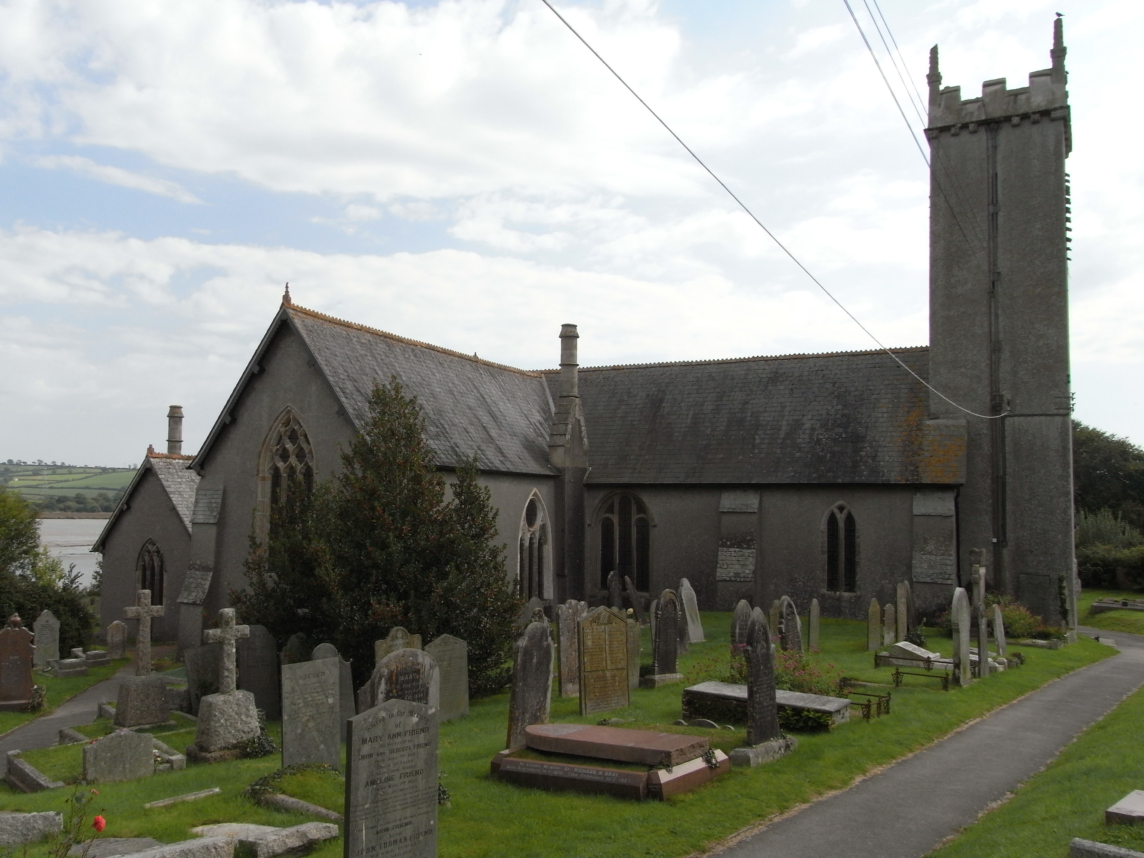
St Andrew's Church, Bere Ferrers

St Andrew's Church in Bere Ferrers, Devon, is a parish church in the Church of England The church contains the oldest stained-glass window in Devon (excluding...

River Tavy

The Tavy () is a river on Dartmoor, Devon, England. The name derives from the Brythonic root "Tam", once thought to mean 'dark' but now generally understood...

Nearby Amenities

Located within 500m of 50.469344,-4.187111
Generator Method: photovoltaic
Generator Output Electricity: yes
Generator Source: solar
Generator Type: solar_photovoltaic_panel
Location: roof
Power: generator
Lat/Long: 50.4724605/-4.1908376
The data included in this document is from www.openstreetmap.org. The data is made available under ODbL.

Have you been to Bere Ferrers?

Leave your review of Bere Ferrers below (or comments, questions and feedback).