Beercrocombe

Civil Parish in Somerset South Somerset

England

Beercrocombe

Hatch Beauchamp : Hatch Court Park A track leads to the church.
Hatch Beauchamp : Hatch Court Park Credit: Lewis Clarke

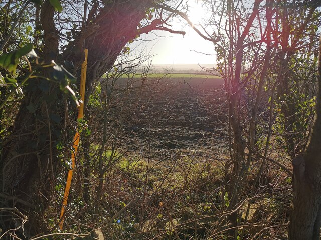
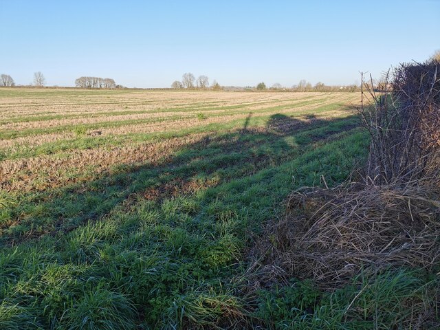
Beercrocombe is a civil parish located in the county of Somerset, England. It is situated approximately 8 miles south of Taunton, the county town. The parish covers an area of around 4 square miles and is surrounded by beautiful countryside, offering picturesque views and a tranquil atmosphere.

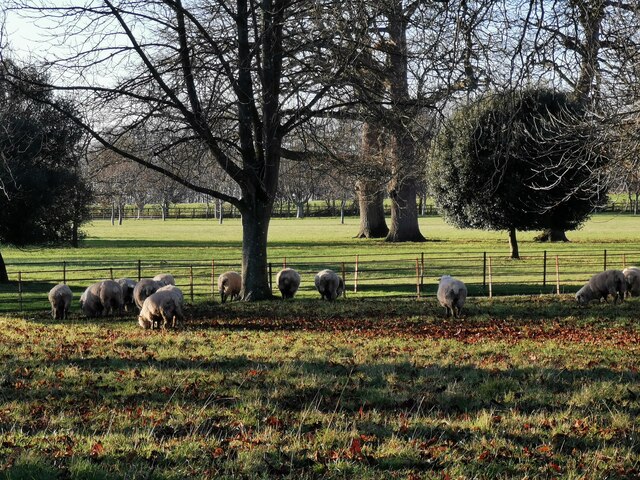
The village of Beercrocombe itself is small, with a population of around 200 residents. It is characterized by its charming thatched cottages and traditional architecture. The parish is primarily a residential area, with a mix of both old and new houses. The local community is close-knit and friendly, with various social events and activities taking place throughout the year.

The parish does not have its own school or shops, but residents can easily access amenities in nearby towns and villages. The village does, however, have a church, St. James's Church, which dates back to the 13th century and is a notable historical landmark in the area.

Beercrocombe is surrounded by rolling hills and farmland, making it an ideal location for nature lovers and those who enjoy outdoor activities. The parish is intersected by several footpaths and bridleways, providing opportunities for walking, cycling, and horse riding.

Overall, Beercrocombe offers a peaceful and idyllic countryside setting, perfect for those seeking a rural retreat while still being within a reasonable distance from urban amenities.

If you have any feedback on the listing, please let us know in the comments section below.

Beercrocombe Images

Images are sourced within 2km of 50.973337/-2.966359 or Grid Reference ST3219. Thanks to Geograph Open Source API. All images are credited.

Hatch Beauchamp : Hatch Court Park A track leads to the church.
Hatch Beauchamp : Hatch Court Park
A track leads to the church.
Hatch Beauchamp : Hatch Court Park Sheep in a field at Hatch Court Park.
Hatch Beauchamp : Hatch Court Park
Sheep in a field at Hatch Court Park.
Hatch Beauchamp : Hatch Court Built in about 1755 in the Palladian style with Bath Stone by the wool merchant John Collins to the design of Thomas Prowse. The site had been occupied since the mediaeval era by various forms of the manor house of the manor of Hatch, the caput of an important feudal barony first held by the Anglo-Norman de Beauchamp family in the 11th century
Hatch Beauchamp : Hatch Court
Built in about 1755 in the Palladian style with Bath Stone by the wool merchant John Collins to the design of Thomas Prowse. The site had been occupied since the mediaeval era by various forms of the manor house of the manor of Hatch, the caput of an important feudal barony first held by the Anglo-Norman de Beauchamp family in the 11th century
Hatch Beauchamp : Grassy Field Looking across a field.
Hatch Beauchamp : Grassy Field
Looking across a field.
Hatch Beauchamp : Frost Street Looking along Frost Street.
Hatch Beauchamp : Frost Street
Looking along Frost Street.
Hatch Beauchamp : Grassy Field A field beyond the open gates.
Hatch Beauchamp : Grassy Field
A field beyond the open gates.
Hatch Beauchamp : Grassy Field & Gate Looking beyond the gate and into the field.
Hatch Beauchamp : Grassy Field & Gate
Looking beyond the gate and into the field.
Curry Mallet : Grassy Field Looking across the field.
Curry Mallet : Grassy Field
Looking across the field.
Curry Mallet : Grassy Field Looking across the countryside.
Curry Mallet : Grassy Field
Looking across the countryside.
Curry Mallet : Countryside Scenery Looking towards Beercrocombe.
Curry Mallet : Countryside Scenery
Looking towards Beercrocombe.
Curry Mallet : Fieldgate Lane Looking along the country lane.
Curry Mallet : Fieldgate Lane
Looking along the country lane.
Curry Mallet : Silver Street Looking along Silver Street, passing Beer Cottage.
Curry Mallet : Silver Street
Looking along Silver Street, passing Beer Cottage.
Curry Mallet : Muddy Field A muddy field in the countryside.
Curry Mallet : Muddy Field
A muddy field in the countryside.
Curry Mallet : Beercrocombe Scenery Looking towards the village of Beer Crocombe. A helicopter hovers above, as it had done for more than an hour.
Curry Mallet : Beercrocombe Scenery
Looking towards the village of Beer Crocombe. A helicopter hovers above, as it had done for more than an hour.
Curry Mallet : Muddy Field Looking into a field.
Curry Mallet : Muddy Field
Looking into a field.
Curry Mallet : Muddy Field Looking out into a muddy field.
Curry Mallet : Muddy Field
Looking out into a muddy field.
Curry Mallet : Grassy Field A field in the countryside.
Curry Mallet : Grassy Field
A field in the countryside.
Curry Mallet : Silver Street Looking along Silver Street.
Curry Mallet : Silver Street
Looking along Silver Street.
Show me another place!

Beercrocombe is located at Grid Ref: ST3219 (Lat: 50.973337, Lng: -2.966359)

Administrative County: Somerset

District: South Somerset

Police Authority: Avon and Somerset

What 3 Words

///pretty.inflating.pepper. Near Ilminster, Somerset

Nearby Locations

Beercrocombe

Related Wikis

Beercrocombe

Beercrocombe (also known as Beer Crocombe) is a village and civil parish in Somerset, England, 1 mile (1.6 km) south of Curry Mallet and 7 miles (11.3...

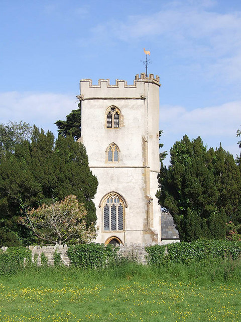
Church of St James, Beercrocombe

The Church of St James in Beercrocombe, Somerset, England, dates from the 13th century but the current building is predominantly from the 15th. It was...

Church of St James, Curry Mallet

The Church of St James is a Church of England parish church in Curry Mallet, Somerset. It has 13th-century origins and has been designated as a Grade I...

Curry Mallet

Curry Mallet (anciently "Cory Mallett") is a village and parish in Somerset, England. It is on the Fivehead River (also known as the River Ile), 7 miles...

Hatch Beauchamp

Hatch Beauchamp is a village and civil parish in Somerset, England, situated 5 miles (8.0 km) south east of Taunton. The village has a population of 620...
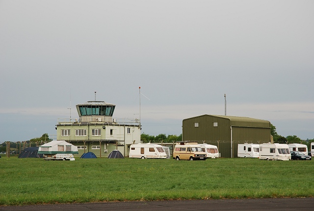
RNAS Merryfield

Royal Naval Air Station Merryfield, commonly known as RNAS Merryfield, is an air station of the Royal Navy's Fleet Air Arm located 2.7 miles (4 kilometres...
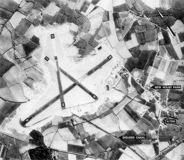
RAF Merryfield

Royal Air Force Merryfield or more simply RAF Merryfield (also known as Isle Abbotts) is a former Royal Air Force station in the village of Ilton near...

Church of the Blessed Virgin Mary, Ashill

The Anglican Church of the Blessed Virgin Mary in Ashill, Somerset, England was built in the 12th century. It is a Grade II* listed building. == History... ==

Nearby Amenities

Located within 500m of 50.973337,-2.966359
Power: pole
Source: bing
Transformer: distribution
Lat/Long: 50.9740062/-2.9726279
Power: pole
Source: bing
Lat/Long: 50.9724017/-2.9631999
Power: pole
Source: bing
Lat/Long: 50.9718021/-2.9624221
Power: pole
Source: bing
Lat/Long: 50.9743634/-2.9649031
Power: pole
Source: bing
Lat/Long: 50.973383/-2.9640716
Power: pole
Source: bing
Lat/Long: 50.9770833/-2.9673252
Power: pole
Source: bing
Lat/Long: 50.9745872/-2.9711178
Power: pole
Source: bing
Lat/Long: 50.9752002/-2.9694816
Power: pole
Source: bing
Lat/Long: 50.9754012/-2.9658633
Power: pole
Source: bing
Lat/Long: 50.9756562/-2.9682612
Power: pole
Source: bing
Lat/Long: 50.9762896/-2.9666331
Power: pole
Source: bing
Lat/Long: 50.977264/-2.9659063
The data included in this document is from www.openstreetmap.org. The data is made available under ODbL.

Have you been to Beercrocombe?

Leave your review of Beercrocombe below (or comments, questions and feedback).