Beachamwell

Civil Parish in Norfolk Breckland

England

Beachamwell

St. Mary's church Beachamwell An interesting and ancient church, built by the Saxons. Typical Saxon openings or windows can be seen on the north and west faces, while on the east and south faces are round headed and may have been replacements after the Conquest with the Norman influence, the octagonal upper stage is 14th c. Inside the nave a high east doorway is easily recognisable. A crow-stepped gable indicates the age of the porch to be about 15th c. A terrible Victorian excuse for a font is used while the far better octagonal one from All Saints stands neglected outside the porch. The unusual profile of the columns of the arcade are interesting, more so the graffiti written thereon in the 14th c. The Jacobean pulpit and reading desk are very good quality.  In the centre of the now extended south aisle is a nice cusped piscina.
St. Mary's church Beachamwell Credit: Adrian S Pye

Beachamwell is a small civil parish located in the county of Norfolk, England. Situated approximately 8 miles south of the market town of Swaffham, it occupies an area of around 10 square kilometers.

The village of Beachamwell is known for its picturesque and tranquil setting, surrounded by beautiful countryside and farmland. It is characterized by its traditional Norfolk architecture, with many historic buildings and thatched cottages lining its streets. The parish is home to a small but close-knit community, comprising of around 150 residents.

The parish is blessed with natural beauty, with the River Wissey flowing through its western boundary. It also boasts several nature reserves, providing habitats for a diverse range of wildlife, including various bird species and rare plants. The surrounding countryside offers excellent opportunities for outdoor activities such as walking, cycling, and horse riding.

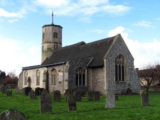
Beachamwell is proud of its rich history, with evidence of human habitation dating back to the Neolithic period. The village is home to the All Saints Church, a Grade II listed building, which dates back to the 14th century. It features stunning stained glass windows and a beautiful tower.

While Beachamwell is a peaceful and idyllic village, it is well-connected to nearby towns and cities. The A134 road runs through the parish, providing convenient access to Swaffham and other larger urban areas. Overall, Beachamwell offers a charming rural retreat, perfect for those seeking a quiet and scenic lifestyle.

If you have any feedback on the listing, please let us know in the comments section below.

Beachamwell Images

Images are sourced within 2km of 52.629237/0.600983 or Grid Reference TF7606. Thanks to Geograph Open Source API. All images are credited.

St. Mary's church Beachamwell An interesting and ancient church, built by the Saxons. Typical Saxon openings or windows can be seen on the north and west faces, while on the east and south faces are round headed and may have been replacements after the Conquest with the Norman influence, the octagonal upper stage is 14th c. Inside the nave a high east doorway is easily recognisable. A crow-stepped gable indicates the age of the porch to be about 15th c. A terrible Victorian excuse for a font is used while the far better octagonal one from All Saints stands neglected outside the porch. The unusual profile of the columns of the arcade are interesting, more so the graffiti written thereon in the 14th c. The Jacobean pulpit and reading desk are very good quality.  In the centre of the now extended south aisle is a nice cusped piscina.
St. Mary's church Beachamwell
An interesting and ancient church, built by the Saxons. Typical Saxon openings or windows can be seen on the north and west faces, while on the east and south faces are round headed and may have been replacements after the Conquest with the Norman influence, the octagonal upper stage is 14th c. Inside the nave a high east doorway is easily recognisable. A crow-stepped gable indicates the age of the porch to be about 15th c. A terrible Victorian excuse for a font is used while the far better octagonal one from All Saints stands neglected outside the porch. The unusual profile of the columns of the arcade are interesting, more so the graffiti written thereon in the 14th c. The Jacobean pulpit and reading desk are very good quality. In the centre of the now extended south aisle is a nice cusped piscina.
Road towards Drymere at Shingham Heath Ordnance Survey Triangulation Pillar Looking eastward.
Road towards Drymere at Shingham Heath Ordnance Survey Triangulation Pillar
Looking eastward.
Shingham St. Botolph's church
Forest Edge: arena with a view, Drymere
Horses grazing, near Warren Farm, Drymere
Bridleway through Swaffham Heath NW of Drymere Near Warren Farm.
Bridleway through Swaffham Heath NW of Drymere
Near Warren Farm.
Bridleway through Swaffham Heath NW of Drymere Near Warren Farm.
Bridleway through Swaffham Heath NW of Drymere
Near Warren Farm.
Approaching Lodge Farm on the bridleway from Drymere A rainstorm came through, one of many over the last few days.
Approaching Lodge Farm on the bridleway from Drymere
A rainstorm came through, one of many over the last few days.
Tethered pony by a bridleway near Lodge Farm, Drymere
Out for a trot down the bridleway, near Lodge Farm, NW of Drymere They came galloping out of the forest on the right.
Those left behind in the field were stirring up trouble...
Out for a trot down the bridleway, near Lodge Farm, NW of Drymere
They came galloping out of the forest on the right. Those left behind in the field were stirring up trouble...
Bridleway north of Lodge Farm through Swaffham Heath
Lodge Farm, Drymere, across the puddle A rainstorm had just gone through.
I wonder what is the history of the brick tower behind the house.
Lodge Farm, Drymere, across the puddle
A rainstorm had just gone through. I wonder what is the history of the brick tower behind the house.
Old railway waggons near Lodge Farm, Drymere
Old barns, and other old things, near Lodge Farm, Dymere
Cattle grazing opposite Lodge Farm, Swaffham Heath
Beachamwell War Memorial The Memorial bears 12 names form WW1 and four from WW2.
Beachamwell War Memorial
The Memorial bears 12 names form WW1 and four from WW2.
Outdoor pigs
Outdoor pigs
Outdoor pigs
Outdoor pigs
Show me another place!

Beachamwell is located at Grid Ref: TF7606 (Lat: 52.629237, Lng: 0.600983)

Administrative County: Norfolk

District: Breckland

Police Authority: Norfolk

What 3 Words

///seasons.scrapping.telephone. Near Swaffham, Norfolk

Related Wikis

Beachamwell

Beachamwell is a village and civil parish in the Breckland district of Norfolk, England about 5 miles (8.0 km) south west of Swaffham and 10 miles (16...
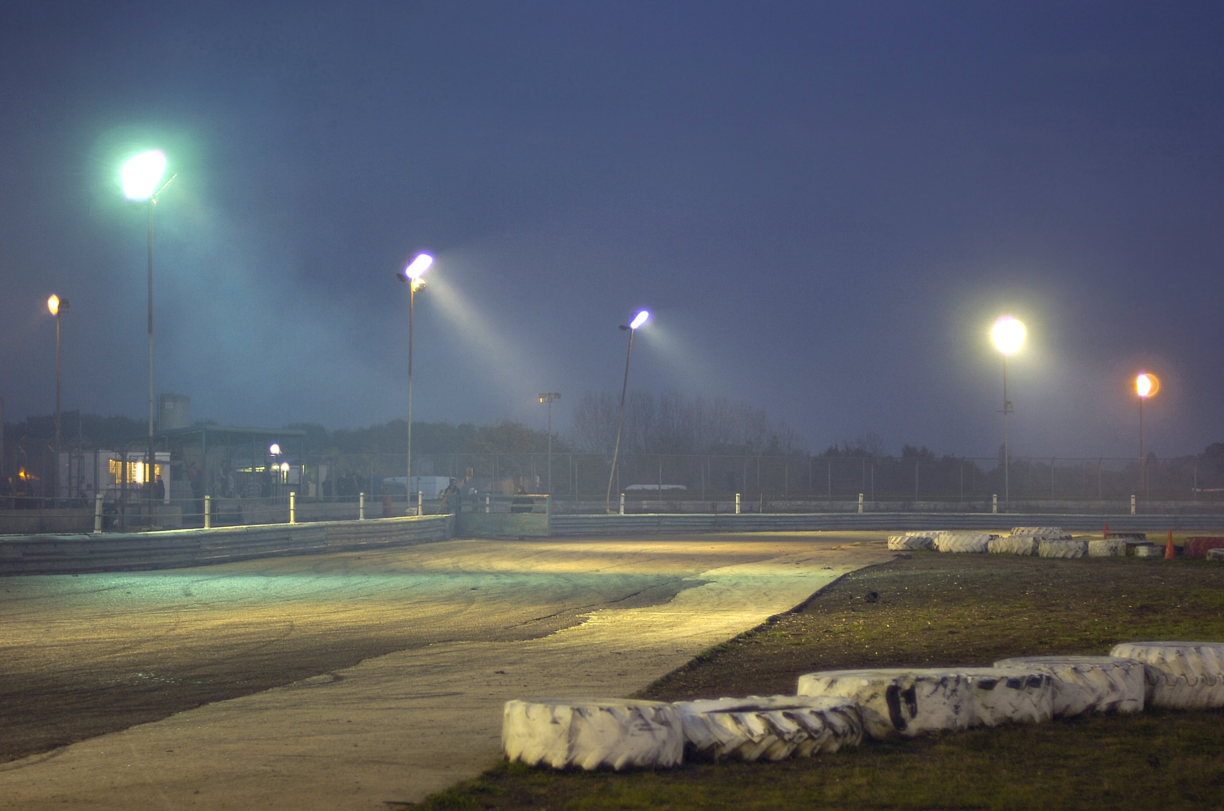
Swaffham Raceway

Swaffham Raceway, originally Swaffham Stadium, is a stock car and banger racing circuit in Swaffham, Norfolk, which also hosted greyhound racing from 1987...

Cockley Cley

Cockley Cley is a village and civil parish in the English county of Norfolk. The village covers an area of 17.94 km2 (6.93 sq mi) and falls within the...

RAF Marham

Royal Air Force Marham, commonly abbreviated RAF Marham (IATA: KNF, ICAO: EGYM) is a Royal Air Force station and military airbase near the village of Marham...

Nearby Amenities

Located within 500m of 52.629237,0.600983
Note: Public Footpath Fingerpost here
Lat/Long: 52.630783/0.6049413
The data included in this document is from www.openstreetmap.org. The data is made available under ODbL.

Have you been to Beachamwell?

Leave your review of Beachamwell below (or comments, questions and feedback).