Brindham

Settlement in Somerset Mendip

England

Brindham

Glastonbury - High Street Glastonbury Tribunal is a historic building dating back to the late 15th century.
<span class="nowrap"><a title="www.glastonbury.gov.uk" rel="nofollow ugc noopener" href="http://www.glastonbury.gov.uk">Link</a><img style="margin-left:2px;" alt="External link" title="External link - shift click to open in new window" src="https://s1.geograph.org.uk/img/external.png" width="10" height="10"/></span>
Glastonbury - High Street Credit: Colin Smith

Brindham is a picturesque village nestled in the heart of Somerset, England. Located just five miles southeast of the historic town of Taunton, it is surrounded by lush green countryside and rolling hills, offering residents and visitors a tranquil and idyllic setting.

The village itself is small, with a population of around 500 residents. It exudes a sense of charm and character with its traditional thatched cottages, quaint village hall, and a charming 12th-century church. Its well-maintained streets are lined with beautiful flower gardens, adding to the village's appeal.

Despite its size, Brindham offers a range of amenities to cater to the needs of its community. There is a local convenience store, a post office, and a small selection of shops and cafes. The village also boasts a primary school, providing education for the local children.

The surrounding countryside offers ample opportunities for outdoor activities, with numerous footpaths and bridleways for walkers, cyclists, and equestrians to explore. Brindham is also home to several nature reserves, attracting wildlife enthusiasts and birdwatchers.

Transport links to Brindham are convenient, with regular bus services connecting the village to nearby towns and cities. The M5 motorway is easily accessible, providing connections to Bristol, Exeter, and beyond.

Overall, Brindham is a charming and peaceful village, perfect for those seeking a slower pace of life and a close-knit community in the beautiful Somerset countryside.

If you have any feedback on the listing, please let us know in the comments section below.

Brindham Images

Images are sourced within 2km of 51.158303/-2.694369 or Grid Reference ST5140. Thanks to Geograph Open Source API. All images are credited.

Glastonbury - High Street Glastonbury Tribunal is a historic building dating back to the late 15th century.
<span class="nowrap"><a title="www.glastonbury.gov.uk" rel="nofollow ugc noopener" href="http://www.glastonbury.gov.uk">Link</a><img style="margin-left:2px;" alt="External link" title="External link - shift click to open in new window" src="https://s1.geograph.org.uk/img/external.png" width="10" height="10"/></span>
Glastonbury - High Street
Glastonbury Tribunal is a historic building dating back to the late 15th century. LinkExternal link
Glastonbury - The Goddess and The Green Man A colourful facade and alternative shopping on the High Street.
<span class="nowrap"><a title="www.glastonbury.gov.uk" rel="nofollow ugc noopener" href="http://www.glastonbury.gov.uk">Link</a><img style="margin-left:2px;" alt="External link" title="External link - shift click to open in new window" src="https://s1.geograph.org.uk/img/external.png" width="10" height="10"/></span>
Glastonbury - The Goddess and The Green Man
A colourful facade and alternative shopping on the High Street. LinkExternal link
Glastonbury - The Goddess Rainbow's End Cafe meets The Goddess - esoteric shops on Glastonbury's High Street.
<span class="nowrap"><a title="www.glastonbury.gov.uk" rel="nofollow ugc noopener" href="http://www.glastonbury.gov.uk">Link</a><img style="margin-left:2px;" alt="External link" title="External link - shift click to open in new window" src="https://s1.geograph.org.uk/img/external.png" width="10" height="10"/></span>
Glastonbury - The Goddess
Rainbow's End Cafe meets The Goddess - esoteric shops on Glastonbury's High Street. LinkExternal link
Awaiting the blooms In the grounds of St John the Baptist is a particular shrub. It is labelled as a Glastonbury Holy Thorn, but is not the original one that flowers at Christmas and reputed to be brought to Avalon by Joseph of Arimathea.
Awaiting the blooms
In the grounds of St John the Baptist is a particular shrub. It is labelled as a Glastonbury Holy Thorn, but is not the original one that flowers at Christmas and reputed to be brought to Avalon by Joseph of Arimathea.
Common Moor This field on the Somerset Levels just west of Glastonbury like many others is used as pasture for sheep. A feed bucket contained a dietary supplement.
Common Moor
This field on the Somerset Levels just west of Glastonbury like many others is used as pasture for sheep. A feed bucket contained a dietary supplement.
Glastonbury Tor from Stone Down Lane NCN3 Glastonbury Tor, photographed from the NCN3 on the junction of Stone Down Lane with Basketfield Lane.
Glastonbury Tor from Stone Down Lane NCN3
Glastonbury Tor, photographed from the NCN3 on the junction of Stone Down Lane with Basketfield Lane.
Glastonbury Tor from Entrance on Stone Down Lane NCN3 The entrance from NCN3 on Stone Down Lane onto the path up to Glastonbury Tor.
Note this a footpath only - there is no access for cycles and there is no cycle rack provided.
Glastonbury Tor from Entrance on Stone Down Lane NCN3
The entrance from NCN3 on Stone Down Lane onto the path up to Glastonbury Tor. Note this a footpath only - there is no access for cycles and there is no cycle rack provided.
Stone Down Lane NCN3 Photograph of Stone Down Lane NCN3, taken looking uphill a little way past the turning off from Wick Lane.
The surface of this section of Stone Down Lane is gravel, with potholes and uneven areas, and will be muddy and potholed in wet weather.
The gradient is steep with 10% sections.
The lane becomes a metalled lane shortly before the junction with Basketfield Lane.
Stone Down Lane NCN3
Photograph of Stone Down Lane NCN3, taken looking uphill a little way past the turning off from Wick Lane. The surface of this section of Stone Down Lane is gravel, with potholes and uneven areas, and will be muddy and potholed in wet weather. The gradient is steep with 10% sections. The lane becomes a metalled lane shortly before the junction with Basketfield Lane.
View over the fields from Gypsy Lane, Edgarley View from the corner of Gypsy Lane and Wick Lane near Edgarley, over the fields towards Glastonbury Tor.
View over the fields from Gypsy Lane, Edgarley
View from the corner of Gypsy Lane and Wick Lane near Edgarley, over the fields towards Glastonbury Tor.
Glastonbury Abbey <span class="nowrap"><a title="https://historicengland.org.uk/listing/the-list/list-entry/1021077?section=official-listing" rel="nofollow ugc noopener" href="https://historicengland.org.uk/listing/the-list/list-entry/1021077?section=official-listing">Link</a><img style="margin-left:2px;" alt="External link" title="External link - shift click to open in new window" src="https://s1.geograph.org.uk/img/external.png" width="10" height="10"/></span>
Glastonbury Abbey
Glastonbury - St John's Church The Norman parish church was rebuilt in Perpendicular Gothic style in the 15th century. The tower dates back to 1475.
Glastonbury - St John's Church
The Norman parish church was rebuilt in Perpendicular Gothic style in the 15th century. The tower dates back to 1475.
Glastonbury - St John's Church Interior Font, east window, altar and pulpit inside this 15th century building.
Glastonbury - St John's Church Interior
Font, east window, altar and pulpit inside this 15th century building.
Glastonbury - Abbey Retreat House Historic building on Chilkwell Street, former home to an Australian pioneer, Austin Family.
<span class="nowrap"><a title="www.glastonbury.gov.uk" rel="nofollow ugc noopener" href="http://www.glastonbury.gov.uk">Link</a><img style="margin-left:2px;" alt="External link" title="External link - shift click to open in new window" src="https://s1.geograph.org.uk/img/external.png" width="10" height="10"/></span>
Glastonbury - Abbey Retreat House
Historic building on Chilkwell Street, former home to an Australian pioneer, Austin Family. LinkExternal link
Glastonbury - Bushy Coombe A nature reserve in a valley on the north side of Chalice Hill.
<span class="nowrap"><a title="www.glastonbury.gov.uk" rel="nofollow ugc noopener" href="http://www.glastonbury.gov.uk">Link</a><img style="margin-left:2px;" alt="External link" title="External link - shift click to open in new window" src="https://s1.geograph.org.uk/img/external.png" width="10" height="10"/></span>
Glastonbury - Bushy Coombe
A nature reserve in a valley on the north side of Chalice Hill. LinkExternal link
Kill Putin An angry message painted on Well House Lane, Glastonbury while Russia has invaded Ukraine, 2022.
Kill Putin
An angry message painted on Well House Lane, Glastonbury while Russia has invaded Ukraine, 2022.
Glastonbury Tor Fabled and landmark hill (520 feet / 158 metres amsl) east of Glastonbury town centre. The tower is all that remains of St Michael's Church.
<span class="nowrap"><a title="www.glastonbury.gov.uk" rel="nofollow ugc noopener" href="http://www.glastonbury.gov.uk">Link</a><img style="margin-left:2px;" alt="External link" title="External link - shift click to open in new window" src="https://s1.geograph.org.uk/img/external.png" width="10" height="10"/></span>
Glastonbury Tor
Fabled and landmark hill (520 feet / 158 metres amsl) east of Glastonbury town centre. The tower is all that remains of St Michael's Church. LinkExternal link
Glastonbury Tor National Trust sign by a footpath leading to the hilltop from the north.
Glastonbury Tor
National Trust sign by a footpath leading to the hilltop from the north.
Glastonbury Tor - Standing Stone Ornate incised stone with carvings and a bell, sited by Well House Lane.
Glastonbury Tor - Standing Stone
Ornate incised stone with carvings and a bell, sited by Well House Lane.
Show me another place!

Brindham is located at Grid Ref: ST5140 (Lat: 51.158303, Lng: -2.694369)

Administrative County: Somerset

District: Mendip

Police Authority: Avon and Somerset

What 3 Words

///mooring.pampered.snow. Near Glastonbury, Somerset

Nearby Locations

Brindham

Related Wikis

Oaks of Avalon

The Oaks of Avalon is the collective name given to a pair of ancient oak trees, Gog and Magog, that stand in Glastonbury in Somerset, South West England...

St Dunstan's School, Glastonbury

St Dunstan's School is a secondary school in Glastonbury, Somerset, England. The school is for students between the ages of 11 and 16 years. It is named...
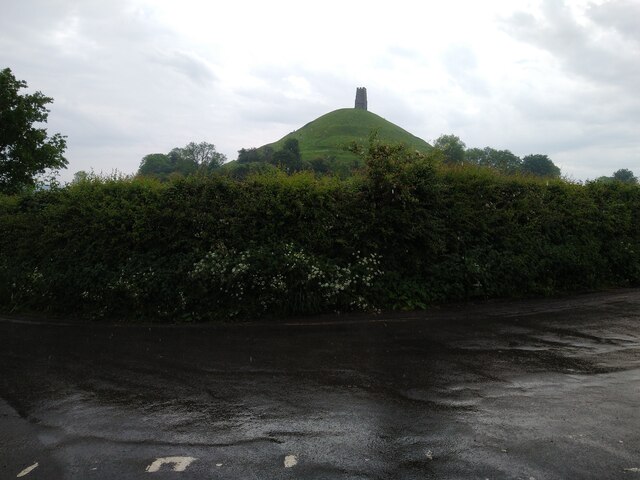
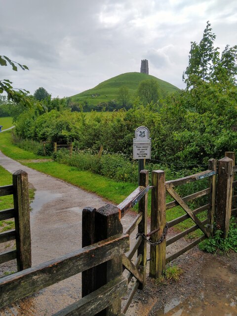
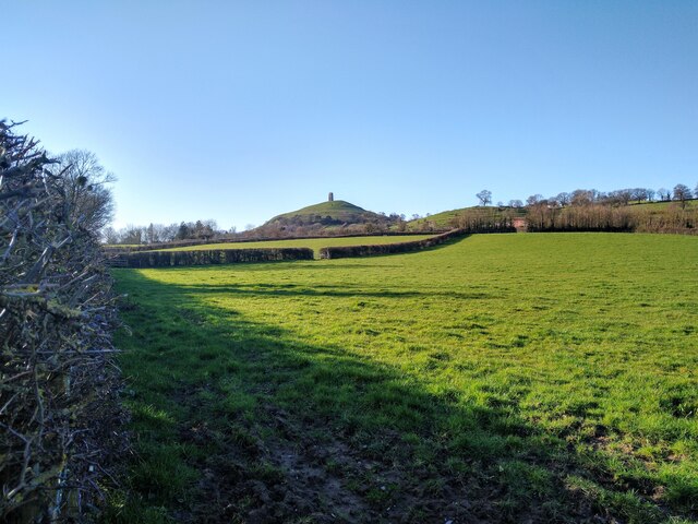
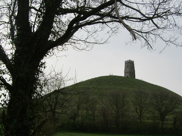
Glastonbury Tor

Glastonbury Tor is a tor near Glastonbury in the English county of Somerset, topped by the roofless St Michael's Tower, a Grade I listed building. The...

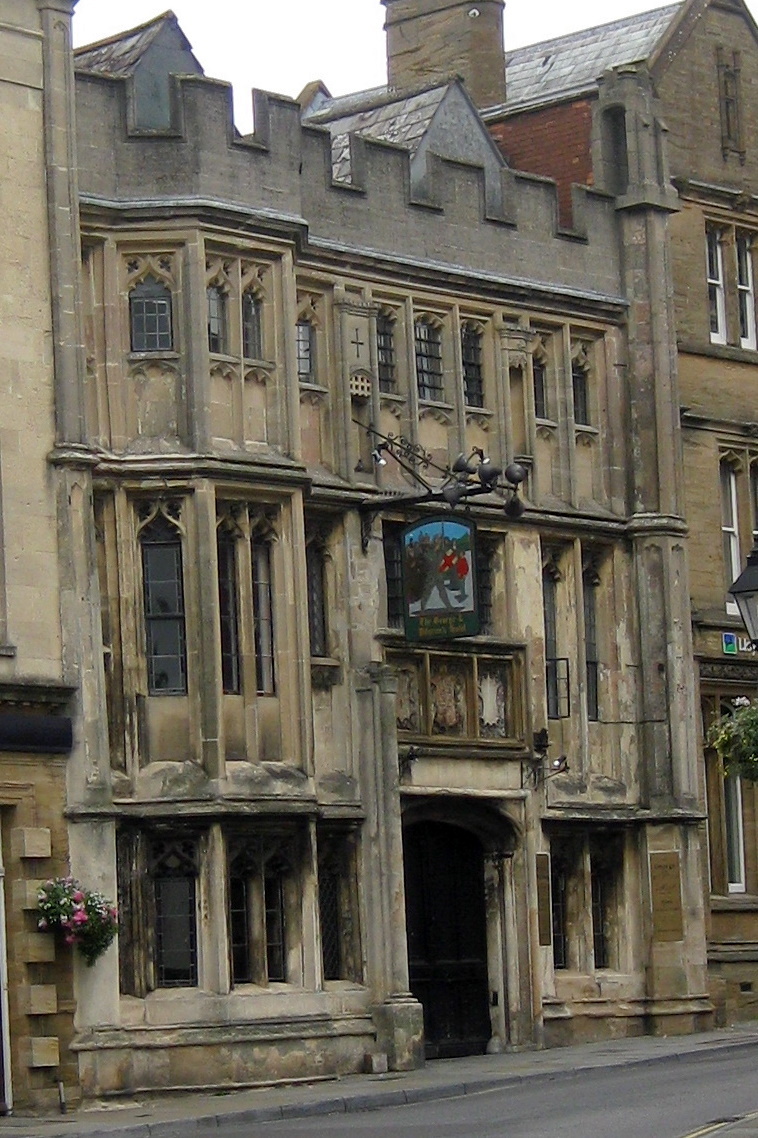
George Hotel and Pilgrims' Inn, Glastonbury

The George Hotel and Pilgrims' Inn in Glastonbury, Somerset, England, was built in the late 15th century to accommodate visitors to Glastonbury Abbey....
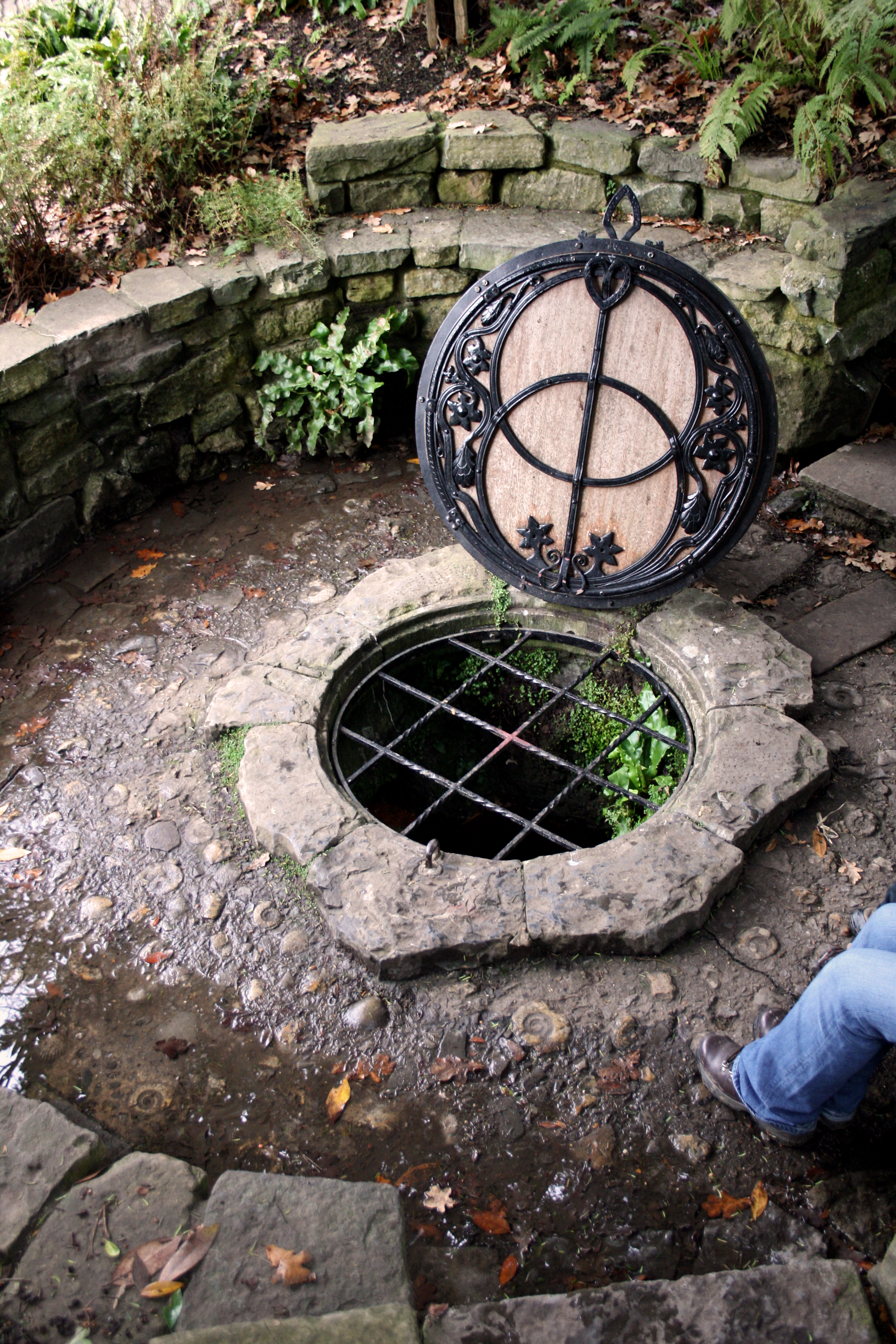
Chalice Well

The Chalice Well, also known as the Red Spring, is a well situated near the summit of Chalice Hill, a small hill next to Glastonbury Tor in Glastonbury...
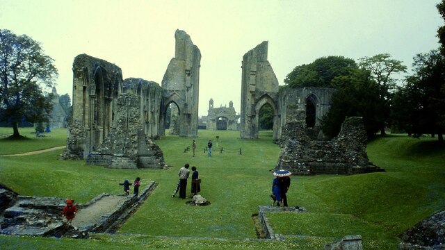
Glastonbury

Glastonbury ( GLAST-ən-bər-ee, UK also GLAHST-) is a town and civil parish in Somerset, England, situated at a dry point on the low-lying Somerset Levels...

Somerset Rural Life Museum

The Somerset Rural Life Museum is situated in Glastonbury, Somerset, UK. It is a museum of the social and agricultural history of Somerset, housed in buildings...

Beckery

Beckery (also Little Ireland) is an area within Glastonbury. It was once the main industrial area of the town. The area is said to have been visited by...

Nearby Amenities

Located within 500m of 51.158303,-2.694369
Mini Roundabout
Direction: clockwise
Lat/Long: 51.1600764/-2.7000219
Barrier: stile
Lat/Long: 51.1569644/-2.6981846
Barrier: stile
Lat/Long: 51.1542942/-2.6962005
The data included in this document is from www.openstreetmap.org. The data is made available under ODbL.

Have you been to Brindham?

Leave your review of Brindham below (or comments, questions and feedback).