Bridgend

Settlement in West Lothian

Scotland

Bridgend

Quarry near Threemiletown
Quarry near Threemiletown Credit: Richard Webb

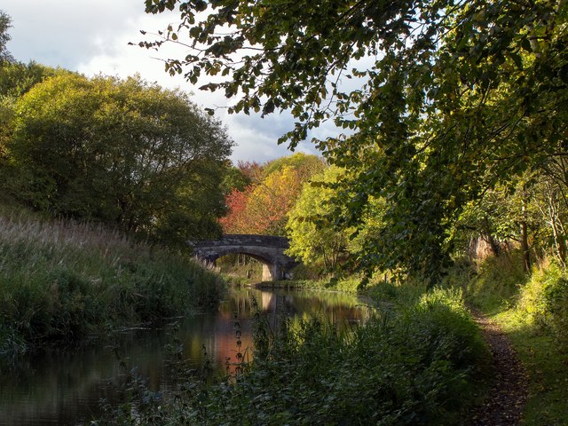
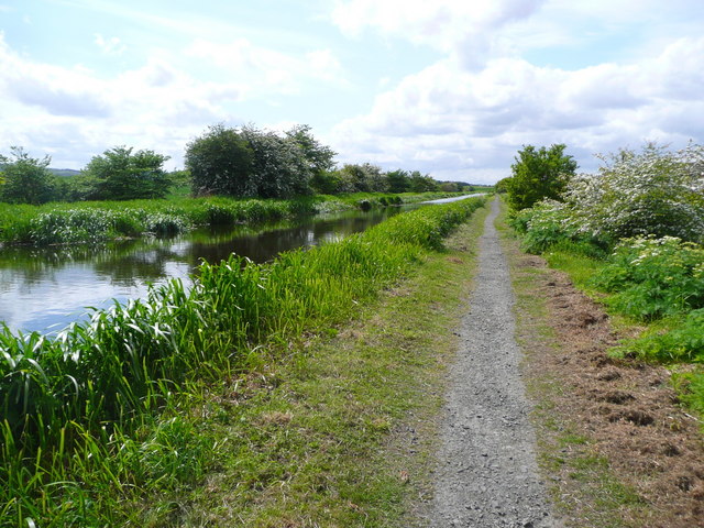
Bridgend is a small village located in West Lothian, Scotland. Situated on the southern bank of the River Almond, it is approximately 2 miles west of the town of Livingston and 15 miles west of Edinburgh.

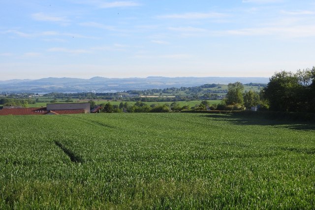
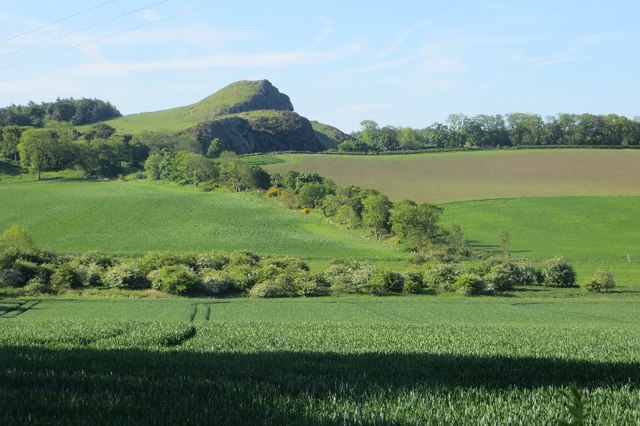
The village is known for its picturesque setting, surrounded by rolling hills and scenic landscapes. It offers a peaceful and tranquil atmosphere, making it an ideal place for those seeking a quieter lifestyle away from the bustling city.

Bridgend has a rich history, with evidence of human settlement dating back to the Neolithic period. The village itself has a charming and traditional character, with a mix of old stone buildings and more modern developments. It is home to a close-knit community that prides itself on its strong sense of community spirit.

Despite its small size, Bridgend offers a range of amenities for residents and visitors alike. There are several local shops, including a convenience store and a post office, providing essential services to the community. The village also has a primary school, ensuring that families with young children have access to education within the local area.

For those who enjoy outdoor activities, Bridgend is surrounded by beautiful countryside, offering ample opportunities for walking, cycling, and exploring nature. The nearby Almondell and Calderwood Country Park is a popular destination, with its expansive woodland and picturesque river walks.

Overall, Bridgend is a charming village that offers a peaceful and idyllic setting, combined with a strong sense of community and easy access to nature.

If you have any feedback on the listing, please let us know in the comments section below.

Bridgend Images

Images are sourced within 2km of 55.964359/-3.534128 or Grid Reference NT0475. Thanks to Geograph Open Source API. All images are credited.

Quarry near Threemiletown
Field, Philpstoun A small area of grass squeezed in between the southern bing and road.
Field, Philpstoun
A small area of grass squeezed in between the southern bing and road.
Field above Bridgend Arable farming, West Lothian.
Field above Bridgend
Arable farming, West Lothian.
View towards Binny Craig Arable land around Oatridge.
View towards Binny Craig
Arable land around Oatridge.
Autumn colours on the Union Canal The trees beyond Bridge 39 add a splash of colour in the afternoon sunshine.
Autumn colours on the Union Canal
The trees beyond Bridge 39 add a splash of colour in the afternoon sunshine.
Bridge over the Union Canal at The Park
The Park Bistro
The Park Bistro
Park Farm Bridge No 41 Crossing the Union Canal near Kingscavil.
Park Farm Bridge No 41
Crossing the Union Canal near Kingscavil.
Visitor moorings along the Union Canal Next to Park Farm Bridge No 41 near Kingscavil.
Visitor moorings along the Union Canal
Next to Park Farm Bridge No 41 near Kingscavil.
View north from the Union Canal towpath
Towpath along the Union Canal Following the completion and opening of the Forth and Clyde Canal in 1790, it was not long before the idea arose of a canal to link Edinburgh to the west, and in particular to the coal mining areas in the west of Scotland, to enable coal to be supplied more cheaply to the capital. Other commodities suited for canal transport included building stone and lime. 

It took another two decades, however, before a survey was undertaken of a route that would link the proposed canal to the Forth and Clyde Canal at Falkirk. The necessary Act of Parliament authorising construction was passed in 1817, and work started at the Edinburgh end, at Port Hopetoun, the following year.

The canal was designed by Hugh Baird <span class="nowrap"><a title="http://en.wikipedia.org/wiki/Hugh_Baird_%28engineer%29" rel="nofollow ugc noopener" href="http://en.wikipedia.org/wiki/Hugh_Baird_%28engineer%29">Link</a><img style="margin-left:2px;" alt="External link" title="External link - shift click to open in new window" src="https://s1.geograph.org.uk/img/external.png" width="10" height="10"/></span> and Thomas Telford <span class="nowrap"><a title="http://en.wikipedia.org/wiki/Thomas_Telford" rel="nofollow ugc noopener" href="http://en.wikipedia.org/wiki/Thomas_Telford">Link</a><img style="margin-left:2px;" alt="External link" title="External link - shift click to open in new window" src="https://s1.geograph.org.uk/img/external.png" width="10" height="10"/></span> and <a title="https://www.geograph.org.uk/discuss/?action=vthread&forum=6&topic=5666" href="https://www.geograph.org.uk/discuss/?action=vthread&forum=6&topic=5666">Link</a> on behalf of the Edinburgh and Glasgow Union Canal Company, whose 384 shareholders included the Lord Provost of Edinburgh and a number of titled persons. 

The canal was originally 32 miles in length and 5 feet deep, and it is a contour canal, that is, it follows the 241 foot (73 metre) contour, except for three river valleys where major aqueducts had to be built to carry the canal across at this height. These are the Slateford Aqueduct over the Water of Leith, the Almond Aqueduct 75 feet (23 metres) above the River Almond at Lin's Mill, and the longest of all at 810 feet (250 metres), the Avon Aqueduct, 86 feet (36 metres) above  the River Avon near Linlithgow. 

Most of the 60-odd bridges are fixed, so neither locks nor opening bridges delayed navigation most of the way, though the aqueducts were only wide enough for boats and barges to travel in one direction at a time; oncoming vessels had to wait until the way was clear. 

A tunnel 690 yards (636 metres) in length was required near Falkirk because the owner of Callendar House, William Forbes,  refused to allow the canal to pass through his land, and this undertaking contributed to the final cost being almost double the original estimate of £240,500. The final bill of over £460,000 equates to anything between £2000 million and £380,000 million at 2014 prices, depending on how it is calculated. 

The water level is maintained from a reservoir in the Pentland Hills, a three-mile channel from the River Almond, and other feeders. 

At Falkirk the Union Canal was 110 feet (33 metres) above the level of the Forth and Clyde Canal, and a flight of eleven locks was built to link the two canals. 

Construction took just four years, and the canal opened for traffic in 1822. Tolls were charged for the carriage of goods, and fares for passengers. There was also income from wharfage. Maximum charges were laid down in the enabling Act of Parliament. The Company was required to pay duties on goods carried to the Burgh of Linlithgow and the City of Edinburgh because the canal took trade away from the turnpike roads maintained by the respective councils.

Early trade was brisk, but unfortunately its heyday lasted only about 20 years, until the Edinburgh and Glasgow Railway superseded it in 1842, and in 1849 the canal was acquired by the railway company. Its use declined steadily over the years, and in the 1930s the flight of eleven locks at Falkirk was filled in and built on. Other stretches of the canal in Edinburgh were also built on, including the Edinburgh terminus. The City Bypass cut the route west of Edinburgh, and the M8 motorway blocked it near Broxburn. The canal was officially closed in 1965, though various stretches were used recreationally, for example for rowing and angling.

Towards the end of the 20th century there was a revival of interest in canals, mainly for recreational use, and the restoration of the Forth and Clyde Canal and the Union Canal was mooted. The project was adopted as one of the major undertakings to mark the millennium, and obtained funding from the European Union and the Millennium Commission among others. A new terminus with associated new retail, residential and commercial buildings was created in Edinburgh and a new stretch of canal dug to replace the section built on at Wester Hailes. The Scott Russell Aqueduct (named after John Scott Russell, who first observed a soliton wave on the canal in 1834) now carries the canal over the City Bypass, and a diversion was built to pass beneath the M8 motorway. The final piece of the restoration was the unique Falkirk Wheel, at the end of an extension to the original canal at Falkirk, which lifts and lowers boats between the Union Canal and the Forth and Clyde Canal. 

The Millennium Link restoration cost some £84 million and the restored canal was opened in 2001. The Falkirk Wheel was opened by Her Majesty Queen Elizabeth the following year.
Towpath along the Union Canal
Following the completion and opening of the Forth and Clyde Canal in 1790, it was not long before the idea arose of a canal to link Edinburgh to the west, and in particular to the coal mining areas in the west of Scotland, to enable coal to be supplied more cheaply to the capital. Other commodities suited for canal transport included building stone and lime. It took another two decades, however, before a survey was undertaken of a route that would link the proposed canal to the Forth and Clyde Canal at Falkirk. The necessary Act of Parliament authorising construction was passed in 1817, and work started at the Edinburgh end, at Port Hopetoun, the following year. The canal was designed by Hugh Baird LinkExternal link and Thomas Telford LinkExternal link and Link on behalf of the Edinburgh and Glasgow Union Canal Company, whose 384 shareholders included the Lord Provost of Edinburgh and a number of titled persons. The canal was originally 32 miles in length and 5 feet deep, and it is a contour canal, that is, it follows the 241 foot (73 metre) contour, except for three river valleys where major aqueducts had to be built to carry the canal across at this height. These are the Slateford Aqueduct over the Water of Leith, the Almond Aqueduct 75 feet (23 metres) above the River Almond at Lin's Mill, and the longest of all at 810 feet (250 metres), the Avon Aqueduct, 86 feet (36 metres) above the River Avon near Linlithgow. Most of the 60-odd bridges are fixed, so neither locks nor opening bridges delayed navigation most of the way, though the aqueducts were only wide enough for boats and barges to travel in one direction at a time; oncoming vessels had to wait until the way was clear. A tunnel 690 yards (636 metres) in length was required near Falkirk because the owner of Callendar House, William Forbes, refused to allow the canal to pass through his land, and this undertaking contributed to the final cost being almost double the original estimate of £240,500. The final bill of over £460,000 equates to anything between £2000 million and £380,000 million at 2014 prices, depending on how it is calculated. The water level is maintained from a reservoir in the Pentland Hills, a three-mile channel from the River Almond, and other feeders. At Falkirk the Union Canal was 110 feet (33 metres) above the level of the Forth and Clyde Canal, and a flight of eleven locks was built to link the two canals. Construction took just four years, and the canal opened for traffic in 1822. Tolls were charged for the carriage of goods, and fares for passengers. There was also income from wharfage. Maximum charges were laid down in the enabling Act of Parliament. The Company was required to pay duties on goods carried to the Burgh of Linlithgow and the City of Edinburgh because the canal took trade away from the turnpike roads maintained by the respective councils. Early trade was brisk, but unfortunately its heyday lasted only about 20 years, until the Edinburgh and Glasgow Railway superseded it in 1842, and in 1849 the canal was acquired by the railway company. Its use declined steadily over the years, and in the 1930s the flight of eleven locks at Falkirk was filled in and built on. Other stretches of the canal in Edinburgh were also built on, including the Edinburgh terminus. The City Bypass cut the route west of Edinburgh, and the M8 motorway blocked it near Broxburn. The canal was officially closed in 1965, though various stretches were used recreationally, for example for rowing and angling. Towards the end of the 20th century there was a revival of interest in canals, mainly for recreational use, and the restoration of the Forth and Clyde Canal and the Union Canal was mooted. The project was adopted as one of the major undertakings to mark the millennium, and obtained funding from the European Union and the Millennium Commission among others. A new terminus with associated new retail, residential and commercial buildings was created in Edinburgh and a new stretch of canal dug to replace the section built on at Wester Hailes. The Scott Russell Aqueduct (named after John Scott Russell, who first observed a soliton wave on the canal in 1834) now carries the canal over the City Bypass, and a diversion was built to pass beneath the M8 motorway. The final piece of the restoration was the unique Falkirk Wheel, at the end of an extension to the original canal at Falkirk, which lifts and lowers boats between the Union Canal and the Forth and Clyde Canal. The Millennium Link restoration cost some £84 million and the restored canal was opened in 2001. The Falkirk Wheel was opened by Her Majesty Queen Elizabeth the following year.
Bridge No 40 crossing the Union Canal
Towpath along the Union Canal Following the completion and opening of the Forth and Clyde Canal in 1790, it was not long before the idea arose of a canal to link Edinburgh to the west, and in particular to the coal mining areas in the west of Scotland, to enable coal to be supplied more cheaply to the capital. Other commodities suited for canal transport included building stone and lime. 

It took another two decades, however, before a survey was undertaken of a route that would link the proposed canal to the Forth and Clyde Canal at Falkirk. The necessary Act of Parliament authorising construction was passed in 1817, and work started at the Edinburgh end, at Port Hopetoun, the following year.

The canal was designed by Hugh Baird <span class="nowrap"><a title="http://en.wikipedia.org/wiki/Hugh_Baird_%28engineer%29" rel="nofollow ugc noopener" href="http://en.wikipedia.org/wiki/Hugh_Baird_%28engineer%29">Link</a><img style="margin-left:2px;" alt="External link" title="External link - shift click to open in new window" src="https://s1.geograph.org.uk/img/external.png" width="10" height="10"/></span> and Thomas Telford <span class="nowrap"><a title="http://en.wikipedia.org/wiki/Thomas_Telford" rel="nofollow ugc noopener" href="http://en.wikipedia.org/wiki/Thomas_Telford">Link</a><img style="margin-left:2px;" alt="External link" title="External link - shift click to open in new window" src="https://s1.geograph.org.uk/img/external.png" width="10" height="10"/></span> and <a title="https://www.geograph.org.uk/discuss/?action=vthread&forum=6&topic=5666" href="https://www.geograph.org.uk/discuss/?action=vthread&forum=6&topic=5666">Link</a> on behalf of the Edinburgh and Glasgow Union Canal Company, whose 384 shareholders included the Lord Provost of Edinburgh and a number of titled persons. 

The canal was originally 32 miles in length and 5 feet deep, and it is a contour canal, that is, it follows the 241 foot (73 metre) contour, except for three river valleys where major aqueducts had to be built to carry the canal across at this height. These are the Slateford Aqueduct over the Water of Leith, the Almond Aqueduct 75 feet (23 metres) above the River Almond at Lin's Mill, and the longest of all at 810 feet (250 metres), the Avon Aqueduct, 86 feet (36 metres) above  the River Avon near Linlithgow. 

Most of the 60-odd bridges are fixed, so neither locks nor opening bridges delayed navigation most of the way, though the aqueducts were only wide enough for boats and barges to travel in one direction at a time; oncoming vessels had to wait until the way was clear. 

A tunnel 690 yards (636 metres) in length was required near Falkirk because the owner of Callendar House, William Forbes,  refused to allow the canal to pass through his land, and this undertaking contributed to the final cost being almost double the original estimate of £240,500. The final bill of over £460,000 equates to anything between £2000 million and £380,000 million at 2014 prices, depending on how it is calculated. 

The water level is maintained from a reservoir in the Pentland Hills, a three-mile channel from the River Almond, and other feeders. 

At Falkirk the Union Canal was 110 feet (33 metres) above the level of the Forth and Clyde Canal, and a flight of eleven locks was built to link the two canals. 

Construction took just four years, and the canal opened for traffic in 1822. Tolls were charged for the carriage of goods, and fares for passengers. There was also income from wharfage. Maximum charges were laid down in the enabling Act of Parliament. The Company was required to pay duties on goods carried to the Burgh of Linlithgow and the City of Edinburgh because the canal took trade away from the turnpike roads maintained by the respective councils.

Early trade was brisk, but unfortunately its heyday lasted only about 20 years, until the Edinburgh and Glasgow Railway superseded it in 1842, and in 1849 the canal was acquired by the railway company. Its use declined steadily over the years, and in the 1930s the flight of eleven locks at Falkirk was filled in and built on. Other stretches of the canal in Edinburgh were also built on, including the Edinburgh terminus. The City Bypass cut the route west of Edinburgh, and the M8 motorway blocked it near Broxburn. The canal was officially closed in 1965, though various stretches were used recreationally, for example for rowing and angling.

Towards the end of the 20th century there was a revival of interest in canals, mainly for recreational use, and the restoration of the Forth and Clyde Canal and the Union Canal was mooted. The project was adopted as one of the major undertakings to mark the millennium, and obtained funding from the European Union and the Millennium Commission among others. A new terminus with associated new retail, residential and commercial buildings was created in Edinburgh and a new stretch of canal dug to replace the section built on at Wester Hailes. The Scott Russell Aqueduct (named after John Scott Russell, who first observed a soliton wave on the canal in 1834) now carries the canal over the City Bypass, and a diversion was built to pass beneath the M8 motorway. The final piece of the restoration was the unique Falkirk Wheel, at the end of an extension to the original canal at Falkirk, which lifts and lowers boats between the Union Canal and the Forth and Clyde Canal. 

The Millennium Link restoration cost some £84 million and the restored canal was opened in 2001. The Falkirk Wheel was opened by Her Majesty Queen Elizabeth the following year.
Towpath along the Union Canal
Following the completion and opening of the Forth and Clyde Canal in 1790, it was not long before the idea arose of a canal to link Edinburgh to the west, and in particular to the coal mining areas in the west of Scotland, to enable coal to be supplied more cheaply to the capital. Other commodities suited for canal transport included building stone and lime. It took another two decades, however, before a survey was undertaken of a route that would link the proposed canal to the Forth and Clyde Canal at Falkirk. The necessary Act of Parliament authorising construction was passed in 1817, and work started at the Edinburgh end, at Port Hopetoun, the following year. The canal was designed by Hugh Baird LinkExternal link and Thomas Telford LinkExternal link and Link on behalf of the Edinburgh and Glasgow Union Canal Company, whose 384 shareholders included the Lord Provost of Edinburgh and a number of titled persons. The canal was originally 32 miles in length and 5 feet deep, and it is a contour canal, that is, it follows the 241 foot (73 metre) contour, except for three river valleys where major aqueducts had to be built to carry the canal across at this height. These are the Slateford Aqueduct over the Water of Leith, the Almond Aqueduct 75 feet (23 metres) above the River Almond at Lin's Mill, and the longest of all at 810 feet (250 metres), the Avon Aqueduct, 86 feet (36 metres) above the River Avon near Linlithgow. Most of the 60-odd bridges are fixed, so neither locks nor opening bridges delayed navigation most of the way, though the aqueducts were only wide enough for boats and barges to travel in one direction at a time; oncoming vessels had to wait until the way was clear. A tunnel 690 yards (636 metres) in length was required near Falkirk because the owner of Callendar House, William Forbes, refused to allow the canal to pass through his land, and this undertaking contributed to the final cost being almost double the original estimate of £240,500. The final bill of over £460,000 equates to anything between £2000 million and £380,000 million at 2014 prices, depending on how it is calculated. The water level is maintained from a reservoir in the Pentland Hills, a three-mile channel from the River Almond, and other feeders. At Falkirk the Union Canal was 110 feet (33 metres) above the level of the Forth and Clyde Canal, and a flight of eleven locks was built to link the two canals. Construction took just four years, and the canal opened for traffic in 1822. Tolls were charged for the carriage of goods, and fares for passengers. There was also income from wharfage. Maximum charges were laid down in the enabling Act of Parliament. The Company was required to pay duties on goods carried to the Burgh of Linlithgow and the City of Edinburgh because the canal took trade away from the turnpike roads maintained by the respective councils. Early trade was brisk, but unfortunately its heyday lasted only about 20 years, until the Edinburgh and Glasgow Railway superseded it in 1842, and in 1849 the canal was acquired by the railway company. Its use declined steadily over the years, and in the 1930s the flight of eleven locks at Falkirk was filled in and built on. Other stretches of the canal in Edinburgh were also built on, including the Edinburgh terminus. The City Bypass cut the route west of Edinburgh, and the M8 motorway blocked it near Broxburn. The canal was officially closed in 1965, though various stretches were used recreationally, for example for rowing and angling. Towards the end of the 20th century there was a revival of interest in canals, mainly for recreational use, and the restoration of the Forth and Clyde Canal and the Union Canal was mooted. The project was adopted as one of the major undertakings to mark the millennium, and obtained funding from the European Union and the Millennium Commission among others. A new terminus with associated new retail, residential and commercial buildings was created in Edinburgh and a new stretch of canal dug to replace the section built on at Wester Hailes. The Scott Russell Aqueduct (named after John Scott Russell, who first observed a soliton wave on the canal in 1834) now carries the canal over the City Bypass, and a diversion was built to pass beneath the M8 motorway. The final piece of the restoration was the unique Falkirk Wheel, at the end of an extension to the original canal at Falkirk, which lifts and lowers boats between the Union Canal and the Forth and Clyde Canal. The Millennium Link restoration cost some £84 million and the restored canal was opened in 2001. The Falkirk Wheel was opened by Her Majesty Queen Elizabeth the following year.
Houses next to the Union Canal towpath The houses are on Cameron Knowe in Philpstoun, West Lothian.
Houses next to the Union Canal towpath
The houses are on Cameron Knowe in Philpstoun, West Lothian.
Philpstoun Aqueduct along the Union Canal Following the completion and opening of the Forth and Clyde Canal in 1790, it was not long before the idea arose of a canal to link Edinburgh to the west, and in particular to the coal mining areas in the west of Scotland, to enable coal to be supplied more cheaply to the capital. Other commodities suited for canal transport included building stone and lime. 

It took another two decades, however, before a survey was undertaken of a route that would link the proposed canal to the Forth and Clyde Canal at Falkirk. The necessary Act of Parliament authorising construction was passed in 1817, and work started at the Edinburgh end, at Port Hopetoun, the following year.

The canal was designed by Hugh Baird <span class="nowrap"><a title="http://en.wikipedia.org/wiki/Hugh_Baird_%28engineer%29" rel="nofollow ugc noopener" href="http://en.wikipedia.org/wiki/Hugh_Baird_%28engineer%29">Link</a><img style="margin-left:2px;" alt="External link" title="External link - shift click to open in new window" src="https://s1.geograph.org.uk/img/external.png" width="10" height="10"/></span> and Thomas Telford <span class="nowrap"><a title="http://en.wikipedia.org/wiki/Thomas_Telford" rel="nofollow ugc noopener" href="http://en.wikipedia.org/wiki/Thomas_Telford">Link</a><img style="margin-left:2px;" alt="External link" title="External link - shift click to open in new window" src="https://s1.geograph.org.uk/img/external.png" width="10" height="10"/></span> and <a title="https://www.geograph.org.uk/discuss/?action=vthread&forum=6&topic=5666" href="https://www.geograph.org.uk/discuss/?action=vthread&forum=6&topic=5666">Link</a> on behalf of the Edinburgh and Glasgow Union Canal Company, whose 384 shareholders included the Lord Provost of Edinburgh and a number of titled persons. 

The canal was originally 32 miles in length and 5 feet deep, and it is a contour canal, that is, it follows the 241 foot (73 metre) contour, except for three river valleys where major aqueducts had to be built to carry the canal across at this height. These are the Slateford Aqueduct over the Water of Leith, the Almond Aqueduct 75 feet (23 metres) above the River Almond at Lin's Mill, and the longest of all at 810 feet (250 metres), the Avon Aqueduct, 86 feet (36 metres) above  the River Avon near Linlithgow. 

Most of the 60-odd bridges are fixed, so neither locks nor opening bridges delayed navigation most of the way, though the aqueducts were only wide enough for boats and barges to travel in one direction at a time; oncoming vessels had to wait until the way was clear. 

A tunnel 690 yards (636 metres) in length was required near Falkirk because the owner of Callendar House, William Forbes,  refused to allow the canal to pass through his land, and this undertaking contributed to the final cost being almost double the original estimate of £240,500. The final bill of over £460,000 equates to anything between £2000 million and £380,000 million at 2014 prices, depending on how it is calculated. 

The water level is maintained from a reservoir in the Pentland Hills, a three-mile channel from the River Almond, and other feeders. 

At Falkirk the Union Canal was 110 feet (33 metres) above the level of the Forth and Clyde Canal, and a flight of eleven locks was built to link the two canals. 

Construction took just four years, and the canal opened for traffic in 1822. Tolls were charged for the carriage of goods, and fares for passengers. There was also income from wharfage. Maximum charges were laid down in the enabling Act of Parliament. The Company was required to pay duties on goods carried to the Burgh of Linlithgow and the City of Edinburgh because the canal took trade away from the turnpike roads maintained by the respective councils.

Early trade was brisk, but unfortunately its heyday lasted only about 20 years, until the Edinburgh and Glasgow Railway superseded it in 1842, and in 1849 the canal was acquired by the railway company. Its use declined steadily over the years, and in the 1930s the flight of eleven locks at Falkirk was filled in and built on. Other stretches of the canal in Edinburgh were also built on, including the Edinburgh terminus. The City Bypass cut the route west of Edinburgh, and the M8 motorway blocked it near Broxburn. The canal was officially closed in 1965, though various stretches were used recreationally, for example for rowing and angling.

Towards the end of the 20th century there was a revival of interest in canals, mainly for recreational use, and the restoration of the Forth and Clyde Canal and the Union Canal was mooted. The project was adopted as one of the major undertakings to mark the millennium, and obtained funding from the European Union and the Millennium Commission among others. A new terminus with associated new retail, residential and commercial buildings was created in Edinburgh and a new stretch of canal dug to replace the section built on at Wester Hailes. The Scott Russell Aqueduct (named after John Scott Russell, who first observed a soliton wave on the canal in 1834) now carries the canal over the City Bypass, and a diversion was built to pass beneath the M8 motorway. The final piece of the restoration was the unique Falkirk Wheel, at the end of an extension to the original canal at Falkirk, which lifts and lowers boats between the Union Canal and the Forth and Clyde Canal. 

The Millennium Link restoration cost some £84 million and the restored canal was opened in 2001. The Falkirk Wheel was opened by Her Majesty Queen Elizabeth the following year.
Philpstoun Aqueduct along the Union Canal
Following the completion and opening of the Forth and Clyde Canal in 1790, it was not long before the idea arose of a canal to link Edinburgh to the west, and in particular to the coal mining areas in the west of Scotland, to enable coal to be supplied more cheaply to the capital. Other commodities suited for canal transport included building stone and lime. It took another two decades, however, before a survey was undertaken of a route that would link the proposed canal to the Forth and Clyde Canal at Falkirk. The necessary Act of Parliament authorising construction was passed in 1817, and work started at the Edinburgh end, at Port Hopetoun, the following year. The canal was designed by Hugh Baird LinkExternal link and Thomas Telford LinkExternal link and Link on behalf of the Edinburgh and Glasgow Union Canal Company, whose 384 shareholders included the Lord Provost of Edinburgh and a number of titled persons. The canal was originally 32 miles in length and 5 feet deep, and it is a contour canal, that is, it follows the 241 foot (73 metre) contour, except for three river valleys where major aqueducts had to be built to carry the canal across at this height. These are the Slateford Aqueduct over the Water of Leith, the Almond Aqueduct 75 feet (23 metres) above the River Almond at Lin's Mill, and the longest of all at 810 feet (250 metres), the Avon Aqueduct, 86 feet (36 metres) above the River Avon near Linlithgow. Most of the 60-odd bridges are fixed, so neither locks nor opening bridges delayed navigation most of the way, though the aqueducts were only wide enough for boats and barges to travel in one direction at a time; oncoming vessels had to wait until the way was clear. A tunnel 690 yards (636 metres) in length was required near Falkirk because the owner of Callendar House, William Forbes, refused to allow the canal to pass through his land, and this undertaking contributed to the final cost being almost double the original estimate of £240,500. The final bill of over £460,000 equates to anything between £2000 million and £380,000 million at 2014 prices, depending on how it is calculated. The water level is maintained from a reservoir in the Pentland Hills, a three-mile channel from the River Almond, and other feeders. At Falkirk the Union Canal was 110 feet (33 metres) above the level of the Forth and Clyde Canal, and a flight of eleven locks was built to link the two canals. Construction took just four years, and the canal opened for traffic in 1822. Tolls were charged for the carriage of goods, and fares for passengers. There was also income from wharfage. Maximum charges were laid down in the enabling Act of Parliament. The Company was required to pay duties on goods carried to the Burgh of Linlithgow and the City of Edinburgh because the canal took trade away from the turnpike roads maintained by the respective councils. Early trade was brisk, but unfortunately its heyday lasted only about 20 years, until the Edinburgh and Glasgow Railway superseded it in 1842, and in 1849 the canal was acquired by the railway company. Its use declined steadily over the years, and in the 1930s the flight of eleven locks at Falkirk was filled in and built on. Other stretches of the canal in Edinburgh were also built on, including the Edinburgh terminus. The City Bypass cut the route west of Edinburgh, and the M8 motorway blocked it near Broxburn. The canal was officially closed in 1965, though various stretches were used recreationally, for example for rowing and angling. Towards the end of the 20th century there was a revival of interest in canals, mainly for recreational use, and the restoration of the Forth and Clyde Canal and the Union Canal was mooted. The project was adopted as one of the major undertakings to mark the millennium, and obtained funding from the European Union and the Millennium Commission among others. A new terminus with associated new retail, residential and commercial buildings was created in Edinburgh and a new stretch of canal dug to replace the section built on at Wester Hailes. The Scott Russell Aqueduct (named after John Scott Russell, who first observed a soliton wave on the canal in 1834) now carries the canal over the City Bypass, and a diversion was built to pass beneath the M8 motorway. The final piece of the restoration was the unique Falkirk Wheel, at the end of an extension to the original canal at Falkirk, which lifts and lowers boats between the Union Canal and the Forth and Clyde Canal. The Millennium Link restoration cost some £84 million and the restored canal was opened in 2001. The Falkirk Wheel was opened by Her Majesty Queen Elizabeth the following year.
Seat along the Union Canal towpath Following the completion and opening of the Forth and Clyde Canal in 1790, it was not long before the idea arose of a canal to link Edinburgh to the west, and in particular to the coal mining areas in the west of Scotland, to enable coal to be supplied more cheaply to the capital. Other commodities suited for canal transport included building stone and lime. 

It took another two decades, however, before a survey was undertaken of a route that would link the proposed canal to the Forth and Clyde Canal at Falkirk. The necessary Act of Parliament authorising construction was passed in 1817, and work started at the Edinburgh end, at Port Hopetoun, the following year.

The canal was designed by Hugh Baird <span class="nowrap"><a title="http://en.wikipedia.org/wiki/Hugh_Baird_%28engineer%29" rel="nofollow ugc noopener" href="http://en.wikipedia.org/wiki/Hugh_Baird_%28engineer%29">Link</a><img style="margin-left:2px;" alt="External link" title="External link - shift click to open in new window" src="https://s1.geograph.org.uk/img/external.png" width="10" height="10"/></span> and Thomas Telford <span class="nowrap"><a title="http://en.wikipedia.org/wiki/Thomas_Telford" rel="nofollow ugc noopener" href="http://en.wikipedia.org/wiki/Thomas_Telford">Link</a><img style="margin-left:2px;" alt="External link" title="External link - shift click to open in new window" src="https://s1.geograph.org.uk/img/external.png" width="10" height="10"/></span> and <a title="https://www.geograph.org.uk/discuss/?action=vthread&forum=6&topic=5666" href="https://www.geograph.org.uk/discuss/?action=vthread&forum=6&topic=5666">Link</a> on behalf of the Edinburgh and Glasgow Union Canal Company, whose 384 shareholders included the Lord Provost of Edinburgh and a number of titled persons. 

The canal was originally 32 miles in length and 5 feet deep, and it is a contour canal, that is, it follows the 241 foot (73 metre) contour, except for three river valleys where major aqueducts had to be built to carry the canal across at this height. These are the Slateford Aqueduct over the Water of Leith, the Almond Aqueduct 75 feet (23 metres) above the River Almond at Lin's Mill, and the longest of all at 810 feet (250 metres), the Avon Aqueduct, 86 feet (36 metres) above  the River Avon near Linlithgow. 

Most of the 60-odd bridges are fixed, so neither locks nor opening bridges delayed navigation most of the way, though the aqueducts were only wide enough for boats and barges to travel in one direction at a time; oncoming vessels had to wait until the way was clear. 

A tunnel 690 yards (636 metres) in length was required near Falkirk because the owner of Callendar House, William Forbes,  refused to allow the canal to pass through his land, and this undertaking contributed to the final cost being almost double the original estimate of £240,500. The final bill of over £460,000 equates to anything between £2000 million and £380,000 million at 2014 prices, depending on how it is calculated. 

The water level is maintained from a reservoir in the Pentland Hills, a three-mile channel from the River Almond, and other feeders. 

At Falkirk the Union Canal was 110 feet (33 metres) above the level of the Forth and Clyde Canal, and a flight of eleven locks was built to link the two canals. 

Construction took just four years, and the canal opened for traffic in 1822. Tolls were charged for the carriage of goods, and fares for passengers. There was also income from wharfage. Maximum charges were laid down in the enabling Act of Parliament. The Company was required to pay duties on goods carried to the Burgh of Linlithgow and the City of Edinburgh because the canal took trade away from the turnpike roads maintained by the respective councils.

Early trade was brisk, but unfortunately its heyday lasted only about 20 years, until the Edinburgh and Glasgow Railway superseded it in 1842, and in 1849 the canal was acquired by the railway company. Its use declined steadily over the years, and in the 1930s the flight of eleven locks at Falkirk was filled in and built on. Other stretches of the canal in Edinburgh were also built on, including the Edinburgh terminus. The City Bypass cut the route west of Edinburgh, and the M8 motorway blocked it near Broxburn. The canal was officially closed in 1965, though various stretches were used recreationally, for example for rowing and angling.

Towards the end of the 20th century there was a revival of interest in canals, mainly for recreational use, and the restoration of the Forth and Clyde Canal and the Union Canal was mooted. The project was adopted as one of the major undertakings to mark the millennium, and obtained funding from the European Union and the Millennium Commission among others. A new terminus with associated new retail, residential and commercial buildings was created in Edinburgh and a new stretch of canal dug to replace the section built on at Wester Hailes. The Scott Russell Aqueduct (named after John Scott Russell, who first observed a soliton wave on the canal in 1834) now carries the canal over the City Bypass, and a diversion was built to pass beneath the M8 motorway. The final piece of the restoration was the unique Falkirk Wheel, at the end of an extension to the original canal at Falkirk, which lifts and lowers boats between the Union Canal and the Forth and Clyde Canal. 

The Millennium Link restoration cost some £84 million and the restored canal was opened in 2001. The Falkirk Wheel was opened by Her Majesty Queen Elizabeth the following year.
Seat along the Union Canal towpath
Following the completion and opening of the Forth and Clyde Canal in 1790, it was not long before the idea arose of a canal to link Edinburgh to the west, and in particular to the coal mining areas in the west of Scotland, to enable coal to be supplied more cheaply to the capital. Other commodities suited for canal transport included building stone and lime. It took another two decades, however, before a survey was undertaken of a route that would link the proposed canal to the Forth and Clyde Canal at Falkirk. The necessary Act of Parliament authorising construction was passed in 1817, and work started at the Edinburgh end, at Port Hopetoun, the following year. The canal was designed by Hugh Baird LinkExternal link and Thomas Telford LinkExternal link and Link on behalf of the Edinburgh and Glasgow Union Canal Company, whose 384 shareholders included the Lord Provost of Edinburgh and a number of titled persons. The canal was originally 32 miles in length and 5 feet deep, and it is a contour canal, that is, it follows the 241 foot (73 metre) contour, except for three river valleys where major aqueducts had to be built to carry the canal across at this height. These are the Slateford Aqueduct over the Water of Leith, the Almond Aqueduct 75 feet (23 metres) above the River Almond at Lin's Mill, and the longest of all at 810 feet (250 metres), the Avon Aqueduct, 86 feet (36 metres) above the River Avon near Linlithgow. Most of the 60-odd bridges are fixed, so neither locks nor opening bridges delayed navigation most of the way, though the aqueducts were only wide enough for boats and barges to travel in one direction at a time; oncoming vessels had to wait until the way was clear. A tunnel 690 yards (636 metres) in length was required near Falkirk because the owner of Callendar House, William Forbes, refused to allow the canal to pass through his land, and this undertaking contributed to the final cost being almost double the original estimate of £240,500. The final bill of over £460,000 equates to anything between £2000 million and £380,000 million at 2014 prices, depending on how it is calculated. The water level is maintained from a reservoir in the Pentland Hills, a three-mile channel from the River Almond, and other feeders. At Falkirk the Union Canal was 110 feet (33 metres) above the level of the Forth and Clyde Canal, and a flight of eleven locks was built to link the two canals. Construction took just four years, and the canal opened for traffic in 1822. Tolls were charged for the carriage of goods, and fares for passengers. There was also income from wharfage. Maximum charges were laid down in the enabling Act of Parliament. The Company was required to pay duties on goods carried to the Burgh of Linlithgow and the City of Edinburgh because the canal took trade away from the turnpike roads maintained by the respective councils. Early trade was brisk, but unfortunately its heyday lasted only about 20 years, until the Edinburgh and Glasgow Railway superseded it in 1842, and in 1849 the canal was acquired by the railway company. Its use declined steadily over the years, and in the 1930s the flight of eleven locks at Falkirk was filled in and built on. Other stretches of the canal in Edinburgh were also built on, including the Edinburgh terminus. The City Bypass cut the route west of Edinburgh, and the M8 motorway blocked it near Broxburn. The canal was officially closed in 1965, though various stretches were used recreationally, for example for rowing and angling. Towards the end of the 20th century there was a revival of interest in canals, mainly for recreational use, and the restoration of the Forth and Clyde Canal and the Union Canal was mooted. The project was adopted as one of the major undertakings to mark the millennium, and obtained funding from the European Union and the Millennium Commission among others. A new terminus with associated new retail, residential and commercial buildings was created in Edinburgh and a new stretch of canal dug to replace the section built on at Wester Hailes. The Scott Russell Aqueduct (named after John Scott Russell, who first observed a soliton wave on the canal in 1834) now carries the canal over the City Bypass, and a diversion was built to pass beneath the M8 motorway. The final piece of the restoration was the unique Falkirk Wheel, at the end of an extension to the original canal at Falkirk, which lifts and lowers boats between the Union Canal and the Forth and Clyde Canal. The Millennium Link restoration cost some £84 million and the restored canal was opened in 2001. The Falkirk Wheel was opened by Her Majesty Queen Elizabeth the following year.
Union Canal overflow near Philpstoun Next to Bridge No 39, with the backdrop of the shale bings.
Union Canal overflow near Philpstoun
Next to Bridge No 39, with the backdrop of the shale bings.
Philpstoun Bridge No 38 Crossing the Union Canal near Old Philpstoun.
Philpstoun Bridge No 38
Crossing the Union Canal near Old Philpstoun.
Show me another place!

Bridgend is located at Grid Ref: NT0475 (Lat: 55.964359, Lng: -3.534128)

Unitary Authority: West Lothian

Police Authority: The Lothians and Scottish Borders

What 3 Words

///romance.insurance.breakaway. Near Winchburgh, West Lothian

Nearby Locations

Bridgend

Related Wikis

Bridgend, West Lothian

Bridgend is a village which neighbours Linlithgow, in West Lothian, Scotland. It also has a football team called Bridgend United. In 2018 it had an estimated...

Kingscavil

Kingscavil (NT029765) is a small settlement in West Lothian lying between Linlithgow and Bridgend on the old A9 (now the B9080). == History == Kingscavil...

Philpstoun

Philpstoun is a small village in West Lothian, Scotland, situated roughly 2 miles (3.2 km) east of the historic county town of Linlithgow. The village...

Ochiltree Castle, West Lothian

Ochiltree Castle (previously: Uchiltre; meaning: the high town or high dwelling place) is a 16th-century tower house a few miles south east of Linlithgow...

Philpstoun railway station

Philpstoun railway station was a railway station in the village of Philpstoun, to the east of Linlithgow in West Lothian, Scotland. It was located on the...

Diocese of Edinburgh

The Diocese of Edinburgh is one of the seven dioceses of the Scottish Episcopal Church. It covers the City of Edinburgh, the Lothians, the Borders and...

Ecclesmachan

Ecclesmachan (Gaelic: Eaglais Mhachain) (Welsh: Eglwys Machan) (NT058736) is an historic village in West Lothian. It lies just north of Uphall on the...

Winchburgh rail crash

The Winchburgh rail crash was a multi-train rail crash that occurred on Monday 13 October 1862, 1+1⁄2 miles (2.4 km) northwest of Winchburgh in Linlithgowshire...

Nearby Amenities

Located within 500m of 55.964359,-3.534128
Bridgend
Is In: West Lothian, Scotland
Place: village
Wikidata: Q4966528
Wikipedia: en:Bridgend, West Lothian
Lat/Long: 55.9640754/-3.5355139
Post Box
Collection Times: Mo-Fr 15:00; Sa 10:45
Operator: Royal Mail
Post Box Type: pillar
Ref: EH49 18
Royal Cypher: GVIR
Royal Cypher Wikidata: Q33102169
Lat/Long: 55.9636026/-3.5343775
Crossing
Button Operated: yes
Crossing: traffic_signals
Crossing Ref: pelican
Lat/Long: 55.9638585/-3.5342031
Booth: K6
Removed Amenity: telephone
Lat/Long: 55.9639389/-3.5341247
Addr Housenumber: 13
Addr Street: Willowdean
Lat/Long: 55.9640689/-3.5389995
Addr Housenumber: 15
Addr Street: Auldhill Place
Lat/Long: 55.9649166/-3.5360419
Addr Housenumber: 16
Addr Street: Auldhill Entry
Lat/Long: 55.9638069/-3.5350643
Addr Housenumber: 37
Addr Street: Woodside Place
Lat/Long: 55.9627855/-3.5333648
Addr Housenumber: 32
Addr Street: Auldhill Road
Lat/Long: 55.9644968/-3.5339322
Noexit: yes
Lat/Long: 55.9670211/-3.5281858
Bus Stop
Bridgend New Apartments
Bench: no
Bus: yes
Public Transport: platform
Shelter: no
Lat/Long: 55.9668162/-3.5288885
Bus Stop
Bridgend New Apartments
Bench: no
Bus: yes
Layby: yes
Public Transport: platform
Shelter: no
Lat/Long: 55.9668064/-3.5290535
Bus Stop
Bridgend Road End
Bench: yes
Bus: yes
Departures Board: timetable
Layby: yes
Public Transport: platform
Shelter: yes
Lat/Long: 55.9679237/-3.5325992
Bus Stop
Bridgend Road End
Bench: yes
Bus: yes
Departures Board: timetable
Layby: yes
Public Transport: platform
Shelter: yes
Lat/Long: 55.9684041/-3.5349387
Bus Stop
Bus: yes
Public Transport: platform
Lat/Long: 55.96325/-3.5344533
Shop: convenience
Lat/Long: 55.9644942/-3.5338902
Power: pole
Lat/Long: 55.9650259/-3.528208
Power: pole
Lat/Long: 55.9663469/-3.5280431
Power: pole
Lat/Long: 55.9658353/-3.5280994
Power: pole
Lat/Long: 55.9654148/-3.5281391
Power: pole
Lat/Long: 55.9646837/-3.5296479
Power: pole
Lat/Long: 55.9644092/-3.530781
Power: pole
Lat/Long: 55.964123/-3.5319434
Power: pole
Lat/Long: 55.9620152/-3.5407228
Power: pole
Lat/Long: 55.9620585/-3.5397107
Power: pole
Lat/Long: 55.9620958/-3.5386005
Power: pole
Lat/Long: 55.9621356/-3.5375049
Power: pole
Lat/Long: 55.961395/-3.5374151
Power: pole
Lat/Long: 55.9606497/-3.5373025
Historic: mine
Mineral: shale
Lat/Long: 55.9612444/-3.5296586
Power: pole
Lat/Long: 55.9685023/-3.535555
Power: pole
Lat/Long: 55.96845/-3.5369758
The data included in this document is from www.openstreetmap.org. The data is made available under ODbL.

Have you been to Bridgend?

Leave your review of Bridgend below (or comments, questions and feedback).