Bricklehampton

Settlement in Worcestershire Wychavon

England

Bricklehampton

St Peter's Church in Little Comberton
St Peter's Church in Little Comberton Credit: Sarah Charlesworth

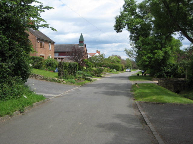
Bricklehampton is a charming village located in the county of Worcestershire, England. Situated approximately five miles west of Pershore, this picturesque village is nestled in the heart of the countryside and offers a tranquil setting for its residents and visitors.

The village is known for its idyllic rural landscape, characterized by rolling hills, lush green fields, and meandering streams. It is a haven for nature lovers, hikers, and those seeking a peaceful retreat from the hustle and bustle of city life.

Bricklehampton is a small community with a close-knit feel, comprising mainly of traditional stone cottages and farmhouses. The village has a rich history dating back centuries, evident in its well-preserved medieval church, St. Michael's, which stands proudly at its center.

Despite its small size, Bricklehampton boasts a strong sense of community spirit. The village hosts various events and activities, such as summer fĂȘtes and local gatherings, which bring residents together and foster a sense of belonging.

While Bricklehampton may lack certain amenities found in larger towns, it benefits from its close proximity to Pershore, where residents can access a range of shops, schools, and services. Additionally, the city of Worcester is just a short drive away, offering further amenities and cultural attractions.

In conclusion, Bricklehampton is a picturesque village in Worcestershire that offers a peaceful and scenic countryside setting. Its rich history, sense of community, and proximity to nearby towns make it an attractive place to live or visit for those seeking a serene rural experience.

If you have any feedback on the listing, please let us know in the comments section below.

Bricklehampton Images

Images are sourced within 2km of 52.076697/-2.033951 or Grid Reference SO9742. Thanks to Geograph Open Source API. All images are credited.

St Peter's Church in Little Comberton
Turning for Bricklehampton
Road through Elmley Castle
The 'Queen Elizabeth', Elmley Castle
Countryside information board, Elmley Castle A map of walking routes in the area at the car park in Kersoe Lane.
Countryside information board, Elmley Castle
A map of walking routes in the area at the car park in Kersoe Lane.
Children's playground, Elmley Castle Viewed from the car park in Kersoe Lane.
Children's playground, Elmley Castle
Viewed from the car park in Kersoe Lane.
Mill Cottage, Mill Lane, Elmley Castle Viewed from the public footpath which crosses the adjacent field.
Mill Cottage, Mill Lane, Elmley Castle
Viewed from the public footpath which crosses the adjacent field.
Millfield, Elmley Castle
Bank Cottage, The Lane, Bricklehampton
Entrance door and porch, Bricklehampton church
Sheep in field near Hall Farm, Bricklehampton There were many lambs to be seen in this field this day.
Sheep in field near Hall Farm, Bricklehampton
There were many lambs to be seen in this field this day.
Hall Farm, Bricklehampton
Boundary bridge Footpath between Elmley Castle and Bricklehampton.
Boundary bridge
Footpath between Elmley Castle and Bricklehampton.
Little Comberton church Over the North Door, unusual tympanum.
Little Comberton church
Over the North Door, unusual tympanum.
Path to Old House Farm Private drive also a public path.
Path to Old House Farm
Private drive also a public path.
Footbridge by Old House Farm Paths divide on other side, three directions.
Footbridge by Old House Farm
Paths divide on other side, three directions.
Small stream forms the boundary Between Elmey Castle and Netherton.
Small stream forms the boundary
Between Elmey Castle and Netherton.
Bridge over the boundary Footbridge between Elmley Castle and Netherton.
Bridge over the boundary
Footbridge between Elmley Castle and Netherton.
Show me another place!

Bricklehampton is located at Grid Ref: SO9742 (Lat: 52.076697, Lng: -2.033951)

Administrative County: Worcestershire

District: Wychavon

Police Authority: West Mercia

What 3 Words

///scrapping.boarded.expecting. Near Pershore, Worcestershire

Nearby Locations

Bricklehampton

Related Wikis

Bricklehampton

Bricklehampton is a village and civil parish in Worcestershire, England. In the 2021 census the population of the parish was recorded as 236. Its area...

Elmley Castle

Elmley Castle is a village and civil parish in Worcestershire, in England, United Kingdom. It is located on the north side of Bredon Hill 3 miles south...

Netherton, Worcestershire

Netherton is a hamlet with population of 50 living in 20 households. It is part of the civil parish of Elmley Castle, Bricklehampton & Netherton in...

Little Comberton

Little Comberton is a small village in Worcestershire, England. It is located 2.5 miles (4.0 km) to the southeast of Pershore. Little Comberton has a village...

Elmley Castle (castle)

Elmley Castle was a late 11th-century earthwork and timber castle which received stone additions in the 12th and possibly 13th centuries, located 0.5 miles...

Great Comberton

Great Comberton is a village in Worcestershire, England, United Kingdom. == Location == Great Comberton village is located 3 kilometres or two-and-a-half...

Bredon Hill Hoard

The Bredon Hill Hoard (also known as the Bredon Hill Roman Coin Hoard) is a hoard of 3,784 debased silver Roman coins discovered in June 2011 by two metal...

Kersoe

Kersoe is a hamlet in Worcestershire, England. It is at the foot of Bredon Hill an area of outstanding natural beauty.

Nearby Amenities

Located within 500m of 52.076697,-2.033951
Church
Naptan AtcoCode: 2000G073400
Naptan Bearing: N
Naptan BusStopType: CUS
Naptan CommonName: Church
Naptan Indicator: Adj
Naptan Landmark: Church
Naptan NaptanCode: wocgmwag
Naptan Street: New Road
Naptan Verified: no
Source: naptan_import
Lat/Long: 52.08008/-2.0293602
Bus Stop
opposite Bricklehampton Hall
Bus: yes
Naptan AtcoCode: 2000G073401
Naptan Bearing: SE
Naptan CommonName: opposite Bricklehampton Hall
Naptan Crossing: Bricklehampton Turn
Naptan Indicator: Eastbound
Naptan NaptanCode: wocgmwaj
Naptan Street: Elmley Castle Road
Naptan Verified: no
Public Transport: platform
Source: naptan_import
Lat/Long: 52.0768785/-2.0321889
opposite Bricklehampton Hall
Naptan AtcoCode: 2000G323230
Naptan Bearing: W
Naptan BusStopType: CUS
Naptan CommonName: opposite Bricklehampton Hall
Naptan Indicator: Westbound
Naptan NaptanCode: wocdmajd
Naptan Street: Elmley Castle Road
Naptan Verified: no
Source: naptan_import
Lat/Long: 52.0766177/-2.0325389
Barrier: stile
Lat/Long: 52.0726953/-2.0351232
Barrier: stile
Lat/Long: 52.0744901/-2.039486
Bench
Lat/Long: 52.0769006/-2.0324707
Lyndale
Power: pole
Transformer: distribution
Voltage Primary: 11000
Lat/Long: 52.0755299/-2.028609
Power: pole
Lat/Long: 52.075954/-2.0276367
Power: pole
Lat/Long: 52.0767622/-2.0284145
Power: pole
Lat/Long: 52.0774084/-2.0290207
The Bank Bricklehampton
Power: pole
Transformer: distribution
Voltage Primary: 11000
Lat/Long: 52.0788005/-2.0281979
Power: pole
Lat/Long: 52.0783768/-2.0283012
Bricklehampton
Power: pole
Transformer: distribution
Voltage Primary: 11000
Lat/Long: 52.0782157/-2.029765
Location Transition: yes
Power: pole
Lat/Long: 52.07839/-2.0299367
Power: pole
Lat/Long: 52.0785235/-2.0300587
Power: pole
Lat/Long: 52.0791059/-2.0307885
Power: pole
Lat/Long: 52.0804658/-2.0304792
Power: pole
Lat/Long: 52.0800108/-2.0308882
Bricklehampton Hall
Power: pole
Transformer: distribution
Voltage Primary: 11000
Lat/Long: 52.0786278/-2.0334296
Power: pole
Lat/Long: 52.07911/-2.0329964
Power: pole
Lat/Long: 52.0793931/-2.0323292
Power: pole
Lat/Long: 52.0795258/-2.0313147
Power: pole
Lat/Long: 52.0798901/-2.0323165
Power: pole
Lat/Long: 52.0802593/-2.0333532
Power: pole
Lat/Long: 52.080631/-2.0344086
Hall Farm Elmley Castle
Location Transition: yes
Power: pole
Transformer: distribution
Voltage Primary: 11000
Lat/Long: 52.0808264/-2.0349504
South Lodge Bricklehampton
Power: pole
Transformer: distribution
Voltage Primary: 11000
Lat/Long: 52.0797178/-2.0388725
The data included in this document is from www.openstreetmap.org. The data is made available under ODbL.

Have you been to Bricklehampton?

Leave your review of Bricklehampton below (or comments, questions and feedback).